
Texas state highways
Encyclopedia
Texas state highways are a network of highways owned and maintained by the U.S. state
of Texas
. The Texas Department of Transportation
(TxDOT) is the state agency responsible for the day-to-day operations and maintenance of the system. In addition to the nationally-numbered Interstate highways and U.S. highways, the highway system consists of a main network of state highway
s, loops
and spurs
that provide local access to the Interstate Highways, U.S. Highways, and state highways. The system also includes a large network of farm to market road
s that connect rural areas of the state with urban areas and the rest of the state highway system. The state also owns and maintains some park and recreational roads that are located near and within state and national parks as well as recreational areas. All state highways, regardless of classification, are paved roads.
, Dallas
, Fort Worth
, Houston
, San Angelo
, and San Antonio
. Later that year, the commission designated 26 state highways covering 8865 miles (14,266.8 km) which were to be readily accessible to 89 percent of the state's population.
In 1921, Congress
amended the Federal Aid to Roads Act of 1916 to require the States to take control of road design, construction and maintenance of state highways by 1925. As a result, on January 1, 1924, the Texas Highway Department took full control of maintaining the state highways from the counties within which they resided. In 1925, the state legislature granted the highway department the responsibility of surveying, planning and building highways, and the authorization to acquire new highway rights-of-way by purchasing, or condemning through Eminent Domain, land required for highway construction.
By 1927, the highway system covered 17960 miles (28,903.7 km), of which 96 miles (154.5 km) were concrete, 1060 miles (1,705.9 km) were asphalt, 5000 miles (8,046.7 km) were gravel, shell or stone, and 10000 miles (16,093.4 km) were clay or dirt.
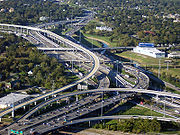
In 1951, a 50 miles (80.5 km) section of the Gulf Freeway (now Interstate 45) opened, becoming Texas' first urban freeway. In 1957, the state began receiving federal funding for the construction of the Interstate Highway System
. The first section of Interstate Highway from county line to county line to open in the state was a 43 miles (69.2 km) section of I-35
in Bexar County
. By 1967, the highway system controlled 66000 miles (106,216.4 km) of highway.
In 1984, US 66 was replaced by I-40
and the US 66 designation was removed from the state highway system the following year. Today, a portion of the original Route 67 between Garland and Greenville is signed as TX-66.
In 1992, the 3200 miles (5,149.9 km) of Interstate Highway System in Texas was completed with the opening of a 6 miles (9.7 km) section of I-27. In 1997, the Texas Turnpike Authority was merged with TxDOT and independently, the North Texas Turnpike Authority became responsible for toll projects in Collin
, Dallas
, Denton
and Tarrant
counties.
In March 2011, Texas ranked as a bottom-ten "Worst" state (tied with Montana
and North Dakota
) in the American State Litter Scorecard, presented at the American Society for Public Administration
national conference. Highways across the Lone Star State suffer from an overall poor quality of public space cleanliness, attributed to ineffective roadside and adjacent property litter/debris abatement standards, politicized procedural efforts, and other public performance indicators.
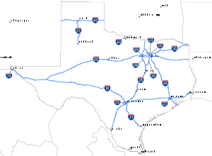 The Interstate Highway System
in Texas covers 3233.4 miles (5,203.6 km) and consists of nine primary routes, six auxiliary routes and the splitting of Interstate 35
(I-35) into two branches, I-35E
and I-35W
, that provide access to both Fort Worth
and Dallas
. The Interstate Highway with the longest segment in Texas is I-10
at 878.6 miles (1,414 km). The shortest Interstate Highway in the state is I-110
at 0.9 miles (1.4 km).
The construction of the Interstate Highway System in Texas actually began well before these routes were designated as Interstate Highways. A 50 miles (80 km) stretch of the Gulf Freeway (I-45) between Galveston and Houston was opened in 1951, eight years before it was designated I-45. It was also the first urban expressway in Texas. In 1962, 43 miles (69 km) of I-35 opened in Bexar County
, the first section of Interstate Highway to open from county line to county line in a large metropolitan area. Portions of I-10 west of San Antonio
took much longer to complete due to the vast open spaces and lack of nearby labor. The majority of the construction of this section of I-10 occurred in the 1970s and 1980s and was complete by the early 1990s. The section east of San Antonio was completed 20 years earlier in 1972. The opening of a 6 miles (10 km) section of I-27 in 1992 completed the Interstate Highway System in Texas.
Planning is ongoing for a proposed extension of I-69
southward from its current terminus in Indiana
through Texas to the United States-Mexico border. If built, I-69 will extend about 650 miles (1,046.1 km) across Texas, from the Louisiana
state line in the Texarkana-Shreveport area to South Texas.
are a nationwide grid of highways, but unlike the Interstate Highway System
, there is no minimum design standard for these highways. This is clearly evident as some stretches of the U.S. Highways in Texas are nothing more than a 2-lane rural road, while others are urban freeways. The U.S. Highways have been replaced for the most part by Interstate Highways for through traffic, the U.S. Highways still serve as important regional connectors. Several notable examples of U.S. Highways that are built to freeway standards include US 75 and US 80 in Dallas
, US 59 and US 290 in Houston
, and US 90 and US 281 in San Antonio
.
The Interstate Highways have replaced several portions of the U.S. Highway network in Texas and as a result, they have been removed from the State Highway System. Several examples include US 81 from Fort Worth to Laredo in favor of I-35
, US 75 from Dallas to Galveston in favor of I-45, and US 80 from Dallas to El Paso in favor of I-10
and I-20
.
(renumbered from Farm to Market Road 495), as well as canceled routes SH 550 (a temporary designation for what is now part of Interstate 30) and SH 824 (a temporary designation for what was later part of SH 24). NASA Road 1 and State Highway OSR are also in the State Highway network. The first 26 state highways were designated in 1917. Highways are not organized by directionality of the highway, instead being generally numbered as they were when first built in the 1920s and 1930s. Most suffixed routes were eliminated by 1939, though State Highway 75A existed from 1946 to 1994 to match Oklahoma
's State Highway 75A.
—is labeled Beltway 8. The first loops and spurs were defined in 1939; prior to that, the roadways had been suffixed segments of the main state highways off of which they branched.
areas. After the city or county acquires right-of-way
, TxDOT builds and maintains the road. A number of these roads, generally west of U.S. Highway 281, are designated ranch to market roads, and one—Ranch Road 1—is simply a ranch road, serving the LBJ Ranch. Farm to market roads were first designated in 1941 and ranch to market roads in 1942. A number of farm to market roads in urban
areas were re-designated in 1995 as urban roads but, amid much controversy, the shields were not changed.
s are assigned to many old alignments of Interstate highways, U.S. highways, state highways and farm to market roads that have been bypassed. In addition to the numerical designation, a unique lettered suffix is assigned to each business route along the highway — for instance, Business Interstate Highway 40-D and Business Farm to Market Road 1960-A. (Not all routes start from A, and letters are sometimes skipped.) These letters are included on the sign in small print below the number. The sign specifications for business Interstate highways do not include the letter, but it has been added to many signs. Prior to 1991, business routes were assigned loop or spur numbers, but signed as business routes (with a BUSINESS plate above the shield for the main route). In 1991, all the business routes were assigned official designations, and their former loop and spur numbers were eliminated.
or national park
s and "recognized recreational areas"; the first ones were defined in 1939 and 1970 respectively. All roads in state parks are maintained by TxDOT, but are generally not numbered.
s; most freeways have continuous frontage roads, one-way
in urban
areas and two-way in rural
areas. Several toll road
s have one-way frontage roads—not necessarily continuous—with State Highway numbers. Most toll roads are marked with special logos, but TxDOT has adopted a new shield as of 2006 for numbered toll roads.
Due to lack of funds the state is increasingly relying on toll roads to expand and maintain its aging highway system. This has sparked much controversy as these toll roads will be privately owned and operated and thus will continue to charge tolls long after the respective road has been paid for.
U.S. state
A U.S. state is any one of the 50 federated states of the United States of America that share sovereignty with the federal government. Because of this shared sovereignty, an American is a citizen both of the federal entity and of his or her state of domicile. Four states use the official title of...
of Texas
Texas
Texas is the second largest U.S. state by both area and population, and the largest state by area in the contiguous United States.The name, based on the Caddo word "Tejas" meaning "friends" or "allies", was applied by the Spanish to the Caddo themselves and to the region of their settlement in...
. The Texas Department of Transportation
Texas Department of Transportation
The Texas Department of Transportation is a governmental agency in the U.S. state of Texas. Its stated mission is to "work cooperatively to provide safe, effective and efficient movement of people and goods" throughout the state...
(TxDOT) is the state agency responsible for the day-to-day operations and maintenance of the system. In addition to the nationally-numbered Interstate highways and U.S. highways, the highway system consists of a main network of state highway
State highway
State highway, state road or state route can refer to one of three related concepts, two of them related to a state or provincial government in a country that is divided into states or provinces :#A...
s, loops
Loop route
A loop route is a highway or other major road that extends out from a typically longer, more important parents road to enter and circle a large city. A loop can function as a bypass for through traffic and also to service outlying suburbs....
and spurs
Spur route
A spur route is a short road forming a branch from a longer, more important route . A bypass or beltway is never considered a true spur route as it typically reconnects with the major road...
that provide local access to the Interstate Highways, U.S. Highways, and state highways. The system also includes a large network of farm to market road
Farm to Market Road
In the United States, a farm-to-market road or ranch-to-market road is a state road or county road which serves to connect rural or agricultural areas to market towns...
s that connect rural areas of the state with urban areas and the rest of the state highway system. The state also owns and maintains some park and recreational roads that are located near and within state and national parks as well as recreational areas. All state highways, regardless of classification, are paved roads.
History
The Texas State Highway System can trace its roots to the establishment of the Texas Highway Department on April 4, 1917. Administrative control of the department was given to a three-member commission appointed by the governor for two-year terms. On June 21, 1917, the commission conducted its first public hearing to solicit input on potential highway routes. The committee also divided the state up into six divisions to be headquartered in AmarilloAmarillo, Texas
Amarillo is the 14th-largest city, by population, in the state of Texas, the largest in the Texas Panhandle, and the seat of Potter County. A portion of the city extends into Randall County. The population was 190,695 at the 2010 census...
, Dallas
Dallas, Texas
Dallas is the third-largest city in Texas and the ninth-largest in the United States. The Dallas-Fort Worth Metroplex is the largest metropolitan area in the South and fourth-largest metropolitan area in the United States...
, Fort Worth
Fort Worth, Texas
Fort Worth is the 16th-largest city in the United States of America and the fifth-largest city in the state of Texas. Located in North Central Texas, just southeast of the Texas Panhandle, the city is a cultural gateway into the American West and covers nearly in Tarrant, Parker, Denton, and...
, Houston
Houston, Texas
Houston is the fourth-largest city in the United States, and the largest city in the state of Texas. According to the 2010 U.S. Census, the city had a population of 2.1 million people within an area of . Houston is the seat of Harris County and the economic center of , which is the ...
, San Angelo
San Angelo, Texas
San Angelo is a city in the state of Texas. Located in West Central Texas it is the county seat of Tom Green County. As of 2010 according to the United States Census Bureau, the city had a total population of 93,200...
, and San Antonio
San Antonio, Texas
San Antonio is the seventh-largest city in the United States of America and the second-largest city within the state of Texas, with a population of 1.33 million. Located in the American Southwest and the south–central part of Texas, the city serves as the seat of Bexar County. In 2011,...
. Later that year, the commission designated 26 state highways covering 8865 miles (14,266.8 km) which were to be readily accessible to 89 percent of the state's population.
In 1921, Congress
United States Congress
The United States Congress is the bicameral legislature of the federal government of the United States, consisting of the Senate and the House of Representatives. The Congress meets in the United States Capitol in Washington, D.C....
amended the Federal Aid to Roads Act of 1916 to require the States to take control of road design, construction and maintenance of state highways by 1925. As a result, on January 1, 1924, the Texas Highway Department took full control of maintaining the state highways from the counties within which they resided. In 1925, the state legislature granted the highway department the responsibility of surveying, planning and building highways, and the authorization to acquire new highway rights-of-way by purchasing, or condemning through Eminent Domain, land required for highway construction.
By 1927, the highway system covered 17960 miles (28,903.7 km), of which 96 miles (154.5 km) were concrete, 1060 miles (1,705.9 km) were asphalt, 5000 miles (8,046.7 km) were gravel, shell or stone, and 10000 miles (16,093.4 km) were clay or dirt.
In 1951, a 50 miles (80.5 km) section of the Gulf Freeway (now Interstate 45) opened, becoming Texas' first urban freeway. In 1957, the state began receiving federal funding for the construction of the Interstate Highway System
Interstate Highway System
The Dwight D. Eisenhower National System of Interstate and Defense Highways, , is a network of limited-access roads including freeways, highways, and expressways forming part of the National Highway System of the United States of America...
. The first section of Interstate Highway from county line to county line to open in the state was a 43 miles (69.2 km) section of I-35
Interstate 35 in Texas
Interstate 35 in Texas is a major north–south Interstate Highway running from Laredo near the United States-Mexico border to the Red River north of Gainesville where it crosses into Oklahoma. Along its route, it passes through the cities of San Antonio, Austin, and Waco before it splits into two...
in Bexar County
Bexar County, Texas
As of the census of 2000, there were 1,392,931 people, 488,942 households, and 345,681 families residing in the county. The population density was 1,117 people per square mile . There were 521,359 housing units at an average density of 418 per square mile...
. By 1967, the highway system controlled 66000 miles (106,216.4 km) of highway.
In 1984, US 66 was replaced by I-40
Interstate 40 in Texas
In the U.S. state of Texas, Interstate 40 runs east–west through the panhandle in the northwest part of the state. The only large city it passes through is Amarillo, where it meets the north end of Interstate 27.-History:...
and the US 66 designation was removed from the state highway system the following year. Today, a portion of the original Route 67 between Garland and Greenville is signed as TX-66.
In 1992, the 3200 miles (5,149.9 km) of Interstate Highway System in Texas was completed with the opening of a 6 miles (9.7 km) section of I-27. In 1997, the Texas Turnpike Authority was merged with TxDOT and independently, the North Texas Turnpike Authority became responsible for toll projects in Collin
Collin County, Texas
As of the census of 2000, there were 491,675 people, 181,970 households, and 132,292 families residing in the county. The population density was 580 people per square mile . There were 194,892 housing units at an average density of 230 per square mile...
, Dallas
Dallas County, Texas
As of the census of 2000, there were 2,218,899 people, 807,621 households, and 533,837 families residing in the county. The population density was 2,523 people per square mile . There were 854,119 housing units at an average density of 971/sq mi...
, Denton
Denton County, Texas
Denton County is a county located in the U.S. state of Texas. In 2000, its population was 432,976; in 2009 the estimated population had reached 628,300. Part of the Dallas – Fort Worth Metroplex, it is one of the fastest-growing counties in the United States. The county seat is Denton. The county...
and Tarrant
Tarrant County, Texas
Tarrant County is a county located in the U.S. state of Texas. As of the 2010 U.S. Census, it had a population of 1,809,034. Its county seat is Fort Worth. Tarrant County is the sixteenth most populous county in the United States and the third most populous in Texas. The county is named in honor...
counties.
In March 2011, Texas ranked as a bottom-ten "Worst" state (tied with Montana
Montana
Montana is a state in the Western United States. The western third of Montana contains numerous mountain ranges. Smaller, "island ranges" are found in the central third of the state, for a total of 77 named ranges of the Rocky Mountains. This geographical fact is reflected in the state's name,...
and North Dakota
North Dakota
North Dakota is a state located in the Midwestern region of the United States of America, along the Canadian border. The state is bordered by Canada to the north, Minnesota to the east, South Dakota to the south and Montana to the west. North Dakota is the 19th-largest state by area in the U.S....
) in the American State Litter Scorecard, presented at the American Society for Public Administration
American Society for Public Administration
The American Society for Public Administration is a membership association in the United States sponsoring conferences and providing professional services primarily to those who study the implementation of government policy, public administration, and, to a lesser degree, programs of civil society...
national conference. Highways across the Lone Star State suffer from an overall poor quality of public space cleanliness, attributed to ineffective roadside and adjacent property litter/debris abatement standards, politicized procedural efforts, and other public performance indicators.
Types of highways
Interstate Highways
Interstate Highway System
The Dwight D. Eisenhower National System of Interstate and Defense Highways, , is a network of limited-access roads including freeways, highways, and expressways forming part of the National Highway System of the United States of America...
in Texas covers 3233.4 miles (5,203.6 km) and consists of nine primary routes, six auxiliary routes and the splitting of Interstate 35
Interstate 35 in Texas
Interstate 35 in Texas is a major north–south Interstate Highway running from Laredo near the United States-Mexico border to the Red River north of Gainesville where it crosses into Oklahoma. Along its route, it passes through the cities of San Antonio, Austin, and Waco before it splits into two...
(I-35) into two branches, I-35E
Interstate 35E (Texas)
Interstate 35E , an Interstate Highway, is the eastern half of Interstate 35 where it splits to serve different cities in Texas. I-35 splits into two branch routes, I-35W and I-35E at Hillsboro. I-35E runs north for , maintaining I-35's sequence of exit numbers. It runs through Dallas before...
and I-35W
Interstate 35W (Texas)
Interstate 35W , an Interstate Highway, is the western half of Interstate 35 where it splits to serve different cities in Texas. I-35 splits into two branch routes, I-35W and I-35E at Hillsboro. I-35W runs north for , carrying its own separate sequence of exit numbers. It runs through Fort Worth...
, that provide access to both Fort Worth
Fort Worth, Texas
Fort Worth is the 16th-largest city in the United States of America and the fifth-largest city in the state of Texas. Located in North Central Texas, just southeast of the Texas Panhandle, the city is a cultural gateway into the American West and covers nearly in Tarrant, Parker, Denton, and...
and Dallas
Dallas, Texas
Dallas is the third-largest city in Texas and the ninth-largest in the United States. The Dallas-Fort Worth Metroplex is the largest metropolitan area in the South and fourth-largest metropolitan area in the United States...
. The Interstate Highway with the longest segment in Texas is I-10
Interstate 10 in Texas
Interstate 10 is the major east–west Interstate Highway in the Southern United States. In the U.S. state of Texas, it runs east from El Paso, near the border with New Mexico, through San Antonio and Houston to the border with Louisiana in Orange, Texas....
at 878.6 miles (1,414 km). The shortest Interstate Highway in the state is I-110
Interstate 110 (Texas)
Interstate 110 is a spur route in El Paso extending from Interstate 10, south along U.S. Highway 54, turns west then turns south into Mexico. Interstate 110 provides access from Interstate 10 to the Bridge of the Americas , which spans the Rio Grande to connect with Avenida Abraham Lincoln in...
at 0.9 miles (1.4 km).
The construction of the Interstate Highway System in Texas actually began well before these routes were designated as Interstate Highways. A 50 miles (80 km) stretch of the Gulf Freeway (I-45) between Galveston and Houston was opened in 1951, eight years before it was designated I-45. It was also the first urban expressway in Texas. In 1962, 43 miles (69 km) of I-35 opened in Bexar County
Bexar County, Texas
As of the census of 2000, there were 1,392,931 people, 488,942 households, and 345,681 families residing in the county. The population density was 1,117 people per square mile . There were 521,359 housing units at an average density of 418 per square mile...
, the first section of Interstate Highway to open from county line to county line in a large metropolitan area. Portions of I-10 west of San Antonio
San Antonio, Texas
San Antonio is the seventh-largest city in the United States of America and the second-largest city within the state of Texas, with a population of 1.33 million. Located in the American Southwest and the south–central part of Texas, the city serves as the seat of Bexar County. In 2011,...
took much longer to complete due to the vast open spaces and lack of nearby labor. The majority of the construction of this section of I-10 occurred in the 1970s and 1980s and was complete by the early 1990s. The section east of San Antonio was completed 20 years earlier in 1972. The opening of a 6 miles (10 km) section of I-27 in 1992 completed the Interstate Highway System in Texas.
Planning is ongoing for a proposed extension of I-69
Interstate 69 in Texas
Interstate 69 in the U.S. state of Texas is a proposed extension of that existing Interstate Highway that would pass through the eastern part of the state.-Route description:In Texas, I-69 will enter from Louisiana to the east and intersect with the U.S...
southward from its current terminus in Indiana
Indiana
Indiana is a US state, admitted to the United States as the 19th on December 11, 1816. It is located in the Midwestern United States and Great Lakes Region. With 6,483,802 residents, the state is ranked 15th in population and 16th in population density. Indiana is ranked 38th in land area and is...
through Texas to the United States-Mexico border. If built, I-69 will extend about 650 miles (1,046.1 km) across Texas, from the Louisiana
Louisiana
Louisiana is a state located in the southern region of the United States of America. Its capital is Baton Rouge and largest city is New Orleans. Louisiana is the only state in the U.S. with political subdivisions termed parishes, which are local governments equivalent to counties...
state line in the Texarkana-Shreveport area to South Texas.
U.S. Highways
The United States Numbered HighwaysUnited States Numbered Highways
The system of United States Numbered Highways is an integrated system of roads and highways in the United States numbered within a nationwide grid...
are a nationwide grid of highways, but unlike the Interstate Highway System
Interstate Highway System
The Dwight D. Eisenhower National System of Interstate and Defense Highways, , is a network of limited-access roads including freeways, highways, and expressways forming part of the National Highway System of the United States of America...
, there is no minimum design standard for these highways. This is clearly evident as some stretches of the U.S. Highways in Texas are nothing more than a 2-lane rural road, while others are urban freeways. The U.S. Highways have been replaced for the most part by Interstate Highways for through traffic, the U.S. Highways still serve as important regional connectors. Several notable examples of U.S. Highways that are built to freeway standards include US 75 and US 80 in Dallas
Dallas, Texas
Dallas is the third-largest city in Texas and the ninth-largest in the United States. The Dallas-Fort Worth Metroplex is the largest metropolitan area in the South and fourth-largest metropolitan area in the United States...
, US 59 and US 290 in Houston
Houston, Texas
Houston is the fourth-largest city in the United States, and the largest city in the state of Texas. According to the 2010 U.S. Census, the city had a population of 2.1 million people within an area of . Houston is the seat of Harris County and the economic center of , which is the ...
, and US 90 and US 281 in San Antonio
San Antonio, Texas
San Antonio is the seventh-largest city in the United States of America and the second-largest city within the state of Texas, with a population of 1.33 million. Located in the American Southwest and the south–central part of Texas, the city serves as the seat of Bexar County. In 2011,...
.
The Interstate Highways have replaced several portions of the U.S. Highway network in Texas and as a result, they have been removed from the State Highway System. Several examples include US 81 from Fort Worth to Laredo in favor of I-35
Interstate 35 in Texas
Interstate 35 in Texas is a major north–south Interstate Highway running from Laredo near the United States-Mexico border to the Red River north of Gainesville where it crosses into Oklahoma. Along its route, it passes through the cities of San Antonio, Austin, and Waco before it splits into two...
, US 75 from Dallas to Galveston in favor of I-45, and US 80 from Dallas to El Paso in favor of I-10
Interstate 10 in Texas
Interstate 10 is the major east–west Interstate Highway in the Southern United States. In the U.S. state of Texas, it runs east from El Paso, near the border with New Mexico, through San Antonio and Houston to the border with Louisiana in Orange, Texas....
and I-20
Interstate 20 in Texas
Interstate 20 in Texas is a major east–west Interstate Highway in the Southern United States, running east from a junction with Interstate 10 east of Kent, Texas, through the Dallas-Fort Worth Metroplex to the border with Louisiana near Waskom, Texas...
.
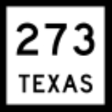
State highways
A state highway (SH) is funded and maintained by the state. State highways have been assigned numbers between 1 and 365 with a few exceptions. There is also a State Highway 495Texas State Highway 495
State Highway 495 or SH 495 is a state highway in the U.S. state of Texas that runs between Mission and Alamo in Deep South Texas. This route was designated in 2001, replacing Farm to Market Road 495. This route runs parallel to US 83 for its entire route...
(renumbered from Farm to Market Road 495), as well as canceled routes SH 550 (a temporary designation for what is now part of Interstate 30) and SH 824 (a temporary designation for what was later part of SH 24). NASA Road 1 and State Highway OSR are also in the State Highway network. The first 26 state highways were designated in 1917. Highways are not organized by directionality of the highway, instead being generally numbered as they were when first built in the 1920s and 1930s. Most suffixed routes were eliminated by 1939, though State Highway 75A existed from 1946 to 1994 to match Oklahoma
Oklahoma
Oklahoma is a state located in the South Central region of the United States of America. With an estimated 3,751,351 residents as of the 2010 census and a land area of 68,667 square miles , Oklahoma is the 28th most populous and 20th-largest state...
's State Highway 75A.
State highway loops and spurs
State highway loops and spurs are short links in the State Highway network. They are generally numbered chronologically, with the lower numbers being older routes. Thus spurs and loops are not related to similarly numbered main state highways. Typically, a loop connects two state or federal highways, and a spur connects a state highway to a farm to market or other lower rated road. Many loops are either bypasses around significant portions of populated areas or older bypassed state or federal roads. One loop—around HoustonHouston, Texas
Houston is the fourth-largest city in the United States, and the largest city in the state of Texas. According to the 2010 U.S. Census, the city had a population of 2.1 million people within an area of . Houston is the seat of Harris County and the economic center of , which is the ...
—is labeled Beltway 8. The first loops and spurs were defined in 1939; prior to that, the roadways had been suffixed segments of the main state highways off of which they branched.
Farm to market roads
Farm to market roads generally exist in ruralRural
Rural areas or the country or countryside are areas that are not urbanized, though when large areas are described, country towns and smaller cities will be included. They have a low population density, and typically much of the land is devoted to agriculture...
areas. After the city or county acquires right-of-way
Easement
An easement is a certain right to use the real property of another without possessing it.Easements are helpful for providing pathways across two or more pieces of property or allowing an individual to fish in a privately owned pond...
, TxDOT builds and maintains the road. A number of these roads, generally west of U.S. Highway 281, are designated ranch to market roads, and one—Ranch Road 1—is simply a ranch road, serving the LBJ Ranch. Farm to market roads were first designated in 1941 and ranch to market roads in 1942. A number of farm to market roads in urban
Urban area
An urban area is characterized by higher population density and vast human features in comparison to areas surrounding it. Urban areas may be cities, towns or conurbations, but the term is not commonly extended to rural settlements such as villages and hamlets.Urban areas are created and further...
areas were re-designated in 1995 as urban roads but, amid much controversy, the shields were not changed.
Business routes
Business routeBusiness route
A business route in the United States and Canada is a short special route connected to a parent numbered highway at its beginning, then routed through the central business district of a nearby city or town, and finally reconnecting with the same parent numbered highway again at its...
s are assigned to many old alignments of Interstate highways, U.S. highways, state highways and farm to market roads that have been bypassed. In addition to the numerical designation, a unique lettered suffix is assigned to each business route along the highway — for instance, Business Interstate Highway 40-D and Business Farm to Market Road 1960-A. (Not all routes start from A, and letters are sometimes skipped.) These letters are included on the sign in small print below the number. The sign specifications for business Interstate highways do not include the letter, but it has been added to many signs. Prior to 1991, business routes were assigned loop or spur numbers, but signed as business routes (with a BUSINESS plate above the shield for the main route). In 1991, all the business routes were assigned official designations, and their former loop and spur numbers were eliminated.
Park and recreational roads
Park Roads and Recreational Roads serve stateState park
State parks are parks or other protected areas managed at the federated state level within those nations which use "state" as a political subdivision. State parks are typically established by a state to preserve a location on account of its natural beauty, historic interest, or recreational...
or national park
National park
A national park is a reserve of natural, semi-natural, or developed land that a sovereign state declares or owns. Although individual nations designate their own national parks differently A national park is a reserve of natural, semi-natural, or developed land that a sovereign state declares or...
s and "recognized recreational areas"; the first ones were defined in 1939 and 1970 respectively. All roads in state parks are maintained by TxDOT, but are generally not numbered.
Toll roads
One characteristic of the highways in Texas are its frontage roadFrontage road
A frontage road is a non-limited access road running parallel to a higher-speed road, usually a freeway, and feeding it at appropriate points of access...
s; most freeways have continuous frontage roads, one-way
One-way traffic
One-way traffic is traffic that moves in a single direction. A one-way street is a street either facilitating only one-way traffic, or designed to direct vehicles to move in one direction.-General signs:...
in urban
Urban area
An urban area is characterized by higher population density and vast human features in comparison to areas surrounding it. Urban areas may be cities, towns or conurbations, but the term is not commonly extended to rural settlements such as villages and hamlets.Urban areas are created and further...
areas and two-way in rural
Rural
Rural areas or the country or countryside are areas that are not urbanized, though when large areas are described, country towns and smaller cities will be included. They have a low population density, and typically much of the land is devoted to agriculture...
areas. Several toll road
Toll road
A toll road is a privately or publicly built road for which a driver pays a toll for use. Structures for which tolls are charged include toll bridges and toll tunnels. Non-toll roads are financed using other sources of revenue, most typically fuel tax or general tax funds...
s have one-way frontage roads—not necessarily continuous—with State Highway numbers. Most toll roads are marked with special logos, but TxDOT has adopted a new shield as of 2006 for numbered toll roads.
Due to lack of funds the state is increasingly relying on toll roads to expand and maintain its aging highway system. This has sparked much controversy as these toll roads will be privately owned and operated and thus will continue to charge tolls long after the respective road has been paid for.
See also
- List of Dallas-Fort Worth area freeways
- List of Houston highways
- List of highways in San Antonio, Texas
External links
- Texas Department of TransportationTexas Department of TransportationThe Texas Department of Transportation is a governmental agency in the U.S. state of Texas. Its stated mission is to "work cooperatively to provide safe, effective and efficient movement of people and goods" throughout the state...
, Highway Designation Files - Texas County Highway Maps
- Texas State Archives Map Collection
- Texas's Former U.S. Highways
- AARoads Texas Highway Page