
Interstate 40 in Texas
Encyclopedia
In the U.S. state
of Texas
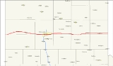
, Interstate 40 (abbreviated I-40) runs east–west through the panhandle in the northwest part of the state. The only large city it passes through is Amarillo
, where it meets the north end of Interstate 27
.
 In 1926, the United States Numbered Highway system was introduced, and the route across the Texas Panhandle was given the number of 66. It was designated along already created roads in the Texas highway network. Large portions of the highway remained earthen roads until the entire route was completely paved in 1938. A few realignments were made to the original route. A new routing on the east side of Amarillo was completed in 1959 to make way for the expansion of the Amarillo Air Force Base, while the rest of the route through Amarillo was rebuilt on the north side of downtown.
In 1956, the Interstate Highway Act was signed, which designated US 66 through Texas as a section of highway eligible for limited access upgrades. During the next 20 years, most of the highway was upgraded in place, to keep construction costs low. With the limited access of the Interstates, most towns on the highway had to be bypassed. Most towns requested to remain as close to the new highway as possible to minimize tourism losses. Bypassed towns included Glenrio, Adrian, Vega, Conway, Groom, Jericho, Alanreed, McLean, and Shamrock. A new routing along the south end of Amarillo was also built, connecting with the already-built expressway leading south from downtown toward Canyon. In 1985, the entire designation of U.S. Route 66 was removed as the entire route had been displaced by Interstate 40.
s. The westernmost part of I-40 in Texas, near the New Mexico
border, lacks the frontage road
s typical to Texas freeways, and several driveway
s for ranch
es directly intersect the main lanes of I-40, in violation of Interstate standards.
 I-40 has seven business route
s in Texas, all of which are old alignments of US 66. A number of other old alignments of US 66 are also present; most are marked on guide signs on I-40.
Business Interstate Highway 40-A (formerly Spur 504) is a Business Spur that runs from I-40 at Glenrio, just east of the New Mexico
state line, southwest to the border. In New Mexico, the road forks - the later paved alignment (ca. 1952) has been cut by Interstate 40, and the earlier alignment west to San Jon is now a dirt road
that had been paved when it was US 66 prior to 1952 but the paving was later removed by Quay County, NM commissioners due to high maintenance costs and low traffic volumes. The old US 66/I-40 Business Loop through Glenrio was bypassed in 1973 by I-40.
Business Interstate Highway 40-B (formerly Loop 550) is a Business Loop through Adrian. The road was bypassed ca. 1969 by I-40, and carried US 66 until its 1985 decommissioning.
Business Interstate Highway 40-C (formerly Loop 551) is a Business Loop through Vega. The road was bypassed ca. 1973 by I-40, and carried US 66 until its 1985 decommissioning.
Business Interstate Highway 40-D (formerly Loop 552) is a long Business Loop through Amarillo. An older alignment - Loop 279 - carried Business U.S. Highway 66. East of Amarillo, Farm to Market Road 2575 is old US 66, rerouted to today's Business I-40 in 1958 by the construction of Amarillo International Airport. Present Business I-40 was bypassed in 1968 by I-40, and carried US 66 until its 1985 decommissioning.
Farm to Market Road 2161 and State Highway 207 carry old US 66 through Conway. The road was bypassed ca. 1966 by I-40, and carried US 66 until its 1985 decommissioning.
Business Interstate Highway 40-F (formerly Loop 554) is a Business Loop through Groom
. The road was bypassed ca. 1980 by I-40, and carried US 66 until its 1985 decommissioning.
The short Loop 271, in addition to providing access to Farm to Market Road 291, is old US 66 through Alanreed
. The road was bypassed in 1953 by US 66, but the bypass was not upgraded to a freeway until ca. 1982.
Business Interstate Highway 40-H (formerly Loop 555) is a Business Loop through McLean. The road was bypassed ca. 1984 by I-40, and carried US 66 until its 1985 decommissioning.
Business Interstate Highway 40-J (formerly Loop 556) is a Business Loop through Shamrock. The road was bypassed ca. 1973 by I-40, and carried US 66 until its 1985 decommissioning.
Spur 30 is a short route from I-40 just west of the Oklahoma
state line southeast to the border. In Oklahoma, the road is unnumbered though Texola, though it picks up Interstate 40 Business at exit 5 to run through Erick. The road was bypassed ca. 1972 by I-40, and carried US 66 until 1976, when it was moved onto I-40 in the area.
U.S. state
A U.S. state is any one of the 50 federated states of the United States of America that share sovereignty with the federal government. Because of this shared sovereignty, an American is a citizen both of the federal entity and of his or her state of domicile. Four states use the official title of...
of Texas
Texas
Texas is the second largest U.S. state by both area and population, and the largest state by area in the contiguous United States.The name, based on the Caddo word "Tejas" meaning "friends" or "allies", was applied by the Spanish to the Caddo themselves and to the region of their settlement in...
, Interstate 40 (abbreviated I-40) runs east–west through the panhandle in the northwest part of the state. The only large city it passes through is Amarillo
Amarillo, Texas
Amarillo is the 14th-largest city, by population, in the state of Texas, the largest in the Texas Panhandle, and the seat of Potter County. A portion of the city extends into Randall County. The population was 190,695 at the 2010 census...
, where it meets the north end of Interstate 27
Interstate 27
Interstate 27 is an intrastate Interstate Highway, located entirely in the U.S. state of Texas, running north from Lubbock to Interstate 40 in Amarillo. These two cities are the only control cities on I-27; other cities and towns served by I-27 include New Deal, Abernathy, Hale Center, Plainview,...
.
History
Before the U.S. Route system, this route was a system of interconnected highway from New Mexico to Oklahoma, and was considered a part of the Texas highway system from New Mexico to Amarillo, and was a portion of the Ozark Trails. In Amarillo, the Ozark route split off to a more southerly route, while general low-grade roads continued east. This entire route closely paralleled the Chicago, Rock Island and Pacific Railway. Most construction through the Panhandle was slow, and remained low-grade roads through most of the 1920s.In 1956, the Interstate Highway Act was signed, which designated US 66 through Texas as a section of highway eligible for limited access upgrades. During the next 20 years, most of the highway was upgraded in place, to keep construction costs low. With the limited access of the Interstates, most towns on the highway had to be bypassed. Most towns requested to remain as close to the new highway as possible to minimize tourism losses. Bypassed towns included Glenrio, Adrian, Vega, Conway, Groom, Jericho, Alanreed, McLean, and Shamrock. A new routing along the south end of Amarillo was also built, connecting with the already-built expressway leading south from downtown toward Canyon. In 1985, the entire designation of U.S. Route 66 was removed as the entire route had been displaced by Interstate 40.
Route description
I-40 in Texas is one of a few Interstate Highways with at-grade intersectionAt-grade intersection
An at-grade intersection is a junction at which two or more transport axes cross at the same level .-Traffic management:With areas of high or fast traffic, an at-grade intersection normally requires a traffic control device such as a stop sign, traffic light or railway signal to manage conflicting...
s. The westernmost part of I-40 in Texas, near the New Mexico
New Mexico
New Mexico is a state located in the southwest and western regions of the United States. New Mexico is also usually considered one of the Mountain States. With a population density of 16 per square mile, New Mexico is the sixth-most sparsely inhabited U.S...
border, lacks the frontage road
Frontage road
A frontage road is a non-limited access road running parallel to a higher-speed road, usually a freeway, and feeding it at appropriate points of access...
s typical to Texas freeways, and several driveway
Driveway
A driveway is a type of private road for local access to one or a small group of structures, and is owned and maintained by an individual or group....
s for ranch
Ranch
A ranch is an area of landscape, including various structures, given primarily to the practice of ranching, the practice of raising grazing livestock such as cattle or sheep for meat or wool. The word most often applies to livestock-raising operations in the western United States and Canada, though...
es directly intersect the main lanes of I-40, in violation of Interstate standards.
Exit list
| County | Location | # Exit number An exit number is a number assigned to a road junction, usually an exit from a freeway. It is usually marked on the same sign as the destinations of the exit, as well as a sign in the gore.... |
Destinations | Notes |
|---|---|---|---|---|
| Deaf Smith | 0 |  Bus. I-40-A – Glenrio Bus. I-40-A – Glenrio |
||
| Oldham | 15 | Ivy Road | ||
| 18 | ||||
| Adrian Adrian, Texas Adrian is a city in Oldham County, Texas, United States. The population was 159 at the 2000 census. A July 1, 2008 U.S. Census Bureau estimate placed the population at 149.-Geography:... |
22 | |||
| 23 | ||||
| 28 | ||||
| 35 | ||||
| Vega Vega, Texas Vega is a city in Oldham County, Texas, United States. It is the county seat of Oldham County . The population was 936 at the 2000 census. A July 1, 2009, U.S. Census Bureau estimate placed the population at 896.... |
36 | |||
| 37 | ||||
| 42 | Everett Road | |||
| 49 | ||||
| Potter | 54 | Adkisson Road | ||
| 57 | ||||
| 60 | Arnot Road | |||
| 62A | Hope Road, Helium Road | |||
| 62B | Eastbound exit and westbound entrance | |||
| Amarillo Amarillo, Texas Amarillo is the 14th-largest city, by population, in the state of Texas, the largest in the Texas Panhandle, and the seat of Potter County. A portion of the city extends into Randall County. The population was 190,695 at the 2010 census... |
64 | |||
| 65 | Coulter Street | |||
| 66 | Bell Street, Avondale Street, Wolflin Avenue | |||
| 67 | Western Street, Avondale Street | |||
| 68A | Julian Boulevard, Paramount Boulevard | |||
| 68B | Georgia Street, Crockett Street | |||
| 69A | Crockett Street | Westbound exit and eastbound entrance | ||
| 69B | Washington Street – Amarillo College Amarillo College Amarillo College is a two-year fully accredited community college in Amarillo, Texas with over 10,000 students that was established in 1929 as Amarillo Junior College... |
|||
| 70 | West end of US 287 overlap | |||
| 71 | Ross-Osage Street, Arthur Street | |||
| 72A | Nelson Street, Quarter Horse Drive | |||
| 72B | Grand Street, Bolton Street | |||
| 73 | Eastern Street, Bolton Street | |||
| 74 | Whitaker Road | |||
| 75 | ||||
| 76 | – Amarillo International Airport | |||
| 77 | ||||
| 78 | East end of US 287 overlap; eastbound exit and westbound entrance | |||
| 80 | – Amarillo College East Campus | |||
| 81 | ||||
| Carson Carson County, Texas Carson County is a county located in the U.S. state of Texas. It is part of the Amarillo metropolitan area. In 2000, its population was 6,516. Carson is named for Samuel Price Carson, the first secretary of state of the Republic of Texas. The seat of the county is Panhandle. It was founded in... |
85 | Durrett Road | Eastbound exit only | |
| 85 | / | No eastbound exit | ||
| 87 | ||||
| 89 | ||||
| 96 | ||||
| 98 | Westbound exit and eastbound entrance | |||
| 105 | ||||
| 109 | ||||
| 110 | ||||
| 112 | ||||
| Groom Groom, Texas Groom is a town in Carson County, Texas, United States. The population was 587 at the 2000 census. It is part of the Amarillo, Texas Metropolitan Statistical Area... |
113 | |||
| Gray | 114 | |||
| Donley Donley County, Texas Donley County is a county located in the U.S. state of Texas. In 2000, its population was 3,828. It is named for Stockton P. Donley, a frontier lawyer. Its county seat is Clarendon.... |
121 | North end of SH 70 overlap | ||
| 124 | South end of SH 70 overlap | |||
| 128 | ||||
| Gray | 132 | Johnson Ranch Road | ||
| Alanreed Alanreed, Texas Alanreed is an unincorporated community in Gray County, Texas, United States. It is part of the Pampa, Texas Micropolitan Statistical Area.The McLean Independent School District serves area students.-External links:... |
135 | |||
| 141 | Eastbound exit and westbound entrance | |||
| McLean McLean, Texas McLean is a town in Gray County, Texas, United States. It is part of the Pampa, Texas Micropolitan Statistical Area. The population was 830 at the 2000 census.-Geography:McLean is located at .... |
142 | |||
| 143 | Westbound exit and eastbound entrance | |||
| 146 | County Line Road | |||
| Wheeler | ||||
| 148 | ||||
| 152 | ||||
| 157 | ||||
| 161 | Eastbound exit and westbound entrance | |||
| Shamrock Shamrock, Texas -Demographics:As of the census of 2000, there were 2,029 people, 852 households, and 550 families residing in the city. The population density was 979.7 people per square mile . There were 1,072 housing units at an average density of 517.6 per square mile... |
163 | |||
| 164 | ||||
| 167 | ||||
| 169 | ||||
| 176 | – Texola Texola, Oklahoma Texola is a town in Beckham County, Oklahoma, United States. The population was 36 at the 2010 census.-Geography:Texola is located at , elevation 2,140 feet .... |
Eastbound exit and westbound entrance |
Business routes and old alignments
Business route
A business route in the United States and Canada is a short special route connected to a parent numbered highway at its beginning, then routed through the central business district of a nearby city or town, and finally reconnecting with the same parent numbered highway again at its...
s in Texas, all of which are old alignments of US 66. A number of other old alignments of US 66 are also present; most are marked on guide signs on I-40.
Business Interstate Highway 40-A (formerly Spur 504) is a Business Spur that runs from I-40 at Glenrio, just east of the New Mexico
New Mexico
New Mexico is a state located in the southwest and western regions of the United States. New Mexico is also usually considered one of the Mountain States. With a population density of 16 per square mile, New Mexico is the sixth-most sparsely inhabited U.S...
state line, southwest to the border. In New Mexico, the road forks - the later paved alignment (ca. 1952) has been cut by Interstate 40, and the earlier alignment west to San Jon is now a dirt road
Dirt road
Dirt road is a common term for an unpaved road made from the native material of the land surface through which it passes, known to highway engineers as subgrade material. Dirt roads are suitable for vehicles; a narrower path for pedestrians, animals, and possibly small vehicles would be called a...
that had been paved when it was US 66 prior to 1952 but the paving was later removed by Quay County, NM commissioners due to high maintenance costs and low traffic volumes. The old US 66/I-40 Business Loop through Glenrio was bypassed in 1973 by I-40.
Business Interstate Highway 40-B (formerly Loop 550) is a Business Loop through Adrian. The road was bypassed ca. 1969 by I-40, and carried US 66 until its 1985 decommissioning.
Business Interstate Highway 40-C (formerly Loop 551) is a Business Loop through Vega. The road was bypassed ca. 1973 by I-40, and carried US 66 until its 1985 decommissioning.
Business Interstate Highway 40-D (formerly Loop 552) is a long Business Loop through Amarillo. An older alignment - Loop 279 - carried Business U.S. Highway 66. East of Amarillo, Farm to Market Road 2575 is old US 66, rerouted to today's Business I-40 in 1958 by the construction of Amarillo International Airport. Present Business I-40 was bypassed in 1968 by I-40, and carried US 66 until its 1985 decommissioning.
Farm to Market Road 2161 and State Highway 207 carry old US 66 through Conway. The road was bypassed ca. 1966 by I-40, and carried US 66 until its 1985 decommissioning.
Business Interstate Highway 40-F (formerly Loop 554) is a Business Loop through Groom
Groom, Texas
Groom is a town in Carson County, Texas, United States. The population was 587 at the 2000 census. It is part of the Amarillo, Texas Metropolitan Statistical Area...
. The road was bypassed ca. 1980 by I-40, and carried US 66 until its 1985 decommissioning.
The short Loop 271, in addition to providing access to Farm to Market Road 291, is old US 66 through Alanreed
Alanreed, Texas
Alanreed is an unincorporated community in Gray County, Texas, United States. It is part of the Pampa, Texas Micropolitan Statistical Area.The McLean Independent School District serves area students.-External links:...
. The road was bypassed in 1953 by US 66, but the bypass was not upgraded to a freeway until ca. 1982.
Business Interstate Highway 40-H (formerly Loop 555) is a Business Loop through McLean. The road was bypassed ca. 1984 by I-40, and carried US 66 until its 1985 decommissioning.
Business Interstate Highway 40-J (formerly Loop 556) is a Business Loop through Shamrock. The road was bypassed ca. 1973 by I-40, and carried US 66 until its 1985 decommissioning.
Spur 30 is a short route from I-40 just west of the Oklahoma
Oklahoma
Oklahoma is a state located in the South Central region of the United States of America. With an estimated 3,751,351 residents as of the 2010 census and a land area of 68,667 square miles , Oklahoma is the 28th most populous and 20th-largest state...
state line southeast to the border. In Oklahoma, the road is unnumbered though Texola, though it picks up Interstate 40 Business at exit 5 to run through Erick. The road was bypassed ca. 1972 by I-40, and carried US 66 until 1976, when it was moved onto I-40 in the area.