

List of Houston highways
Encyclopedia
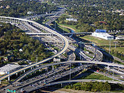
Greater Houston
Houston–Sugar Land–Baytown is a 10-county metropolitan area defined by the Office of Management and Budget. It is located along the Gulf Coast region in the U.S. state of Texas...
metropolitan area.
Present
| Designation | Common Name | Year of First Freeway Section |
Maximum width: mainlanes (HOV) |
Maximum Traffic Count, 2001 (AADT) |
Maximum Traffic Count, 2007 (AADT) |
Maximum Traffic Count, 2008 (AADT) |
Maximum Traffic Count, 2009 (AADT)http://www.dot.state.tx.us/travel/traffic_map2009.htm |
|---|---|---|---|---|---|---|---|
| Baytown-East Freeway | 1953 | 8 | 225,640 | 197,000 | 193,000 | 195,000 | |
| Katy Freeway | 1956 | 16(2) | 238,520 | 246,000 | 276,000 | 268,000 | |
| Gulf Freeway | 1948 | 8(1) | 269,570 | 291,000 | 263,000 | 266,000 | |
| North Freeway | 1959 | 10(1) | 291,470 | 326,000 | 335,000 | 317,000 | |
| 610 Loop | 1952 | 10 | 293,460 | 263,000 | 279,000 | 288,000 | |
| Sam Houston Tollway | 1982 | 9 | 202,900 | 197,000 | 197,000 | 189,000 | |
| Fort Bend Parkway Fort Bend Parkway Toll Road The Fort Bend Parkway Toll Road is the Fort Bend County portion of a continuous toll road connecting State Highway 6 in Missouri City in eastern Fort Bend County to US 90A in southwestern Harris County. It is administered by the Fort Bend County Toll Road Authority... |
2004 | 4 | |||||
| Hardy Toll Road Hardy Toll Road The Hardy Toll Road runs from Interstate 610, near central Houston, to Interstate 45, north of Houston just below the Harris County line. The road generally parallels Interstate 45. The portion from I-610 to Crosstimbers Road is known as Spur 548, although this is unsigned.Construction on the... |
1987 | 6 | 59,220 | 67,000 | 64,000 | 61,000 | |
| Westpark Tollway Westpark Tollway The Westpark Tollway, also Fort Bend Westpark Tollway, is a limited-access toll road serving western Houston and Harris County, and northeastern Fort Bend County. Construction on the facility began in 2001 and portions of the road were opened to traffic in May 2004. Construction of the roadway... |
2004 | 4 | |||||
| Eastex Freeway | 1953 | 10(1) | 211,860 | 228,000 | 208,000 | 195,000 | |
| Southwest Freeway | 1961 | 12(1) | 379,550 | 337,000 | 330,000 | 329,000 | |
| Crosby Freeway | 1991 | 6 | 31,090 | 32,000 | 32,000 | 46,000 | |
| Northwest Freeway | 1975 | 8(1) | 262,970 | 258,000 | 238,000 | 230,000 | |
| Spur 5 | 1988 | 6 | 54,240 | 36,000 | 37,000 | 37,000 | |
| Decker Drive | 2001 | 6 | 32,890 | 44,000 | 45,000 | 37,000 | |
| The Downtown Split | 1961 | 6* | 93,410 | 62,000 | 61,000 | 64,000 | |
| Grand Parkway | 1994 | 4 | 36,200 | 61,000 | 65,000 | 68,000 | |
| Baytown Freeway | 1996 | 8 | 74,670 | 67,000 | 70,000 | 73,000 | |
| Pasadena Freeway | 1966 | 8 | 152,780 | 129,000 | 131,000 | 133,000 | |
| Tomball Parkway | 1990 | 8 | 119,780 | 145,000 | 142,000 | 142,000 | |
| South Freeway | 1980 | 8 | 178,490 | 174,000 | 175,000 | 172,000 | |
| Emmett F. Lowry Expressway | 4 | 48,050 | 40,000 | 39,000 | 40,000 | ||
Future
- Red Bluff Freeway - planned from State Highway 146 southeast of Houston to Beltway 8. Only frontage roads have been built. - Sections A, B, C, E, F1, F2, G, H, and I-1 of Grand Parkway are in various stages of the planning process.- Spur 5 - south-southeast of downtown. The mainlanes planned to be built from its present terminus near University Drive (adjacent to the University of HoustonUniversity of HoustonThe University of Houston is a state research university, and is the flagship institution of the University of Houston System. Founded in 1927, it is Texas's third-largest university with nearly 40,000 students. Its campus spans 667 acres in southeast Houston, and was known as University of...
) to south of Beltway 8.- The Fort Bend Parkway Toll RoadFort Bend Parkway Toll RoadThe Fort Bend Parkway Toll Road is the Fort Bend County portion of a continuous toll road connecting State Highway 6 in Missouri City in eastern Fort Bend County to US 90A in southwestern Harris County. It is administered by the Fort Bend County Toll Road Authority...
is planned to eventually be extended from its northern terminus at US 90A to the southwest corner of the 610 Loop. - The Hardy Toll RoadHardy Toll RoadThe Hardy Toll Road runs from Interstate 610, near central Houston, to Interstate 45, north of Houston just below the Harris County line. The road generally parallels Interstate 45. The portion from I-610 to Crosstimbers Road is known as Spur 548, although this is unsigned.Construction on the...
is planned to be extended from its southern terminus at the North Loop to Downtown Houston. Construction should be completed sometime during 2011. - Fort Bend Westpark Tollway - The Fort Bend section of the Westpark TollwayWestpark TollwayThe Westpark Tollway, also Fort Bend Westpark Tollway, is a limited-access toll road serving western Houston and Harris County, and northeastern Fort Bend County. Construction on the facility began in 2001 and portions of the road were opened to traffic in May 2004. Construction of the roadway...
will eventually be extended west to the growing suburb of FulshearFulshear, TexasFulshear is a city in northwest Fort Bend County, Texas within the Houston–Sugar Land–Baytown metropolitan area. The population was 716 at the 2000 census.-History:The city incorporated in 1977....
. It will then turn north and end at IH-10 around Pederson Road.
Present
- Allen ParkwayAllen ParkwayAllen Parkway is an arterial road west of Downtown Houston, Texas. It has a distance of approximately 2.3 miles , running from Interstate 45 west to Shepherd Drive, where it becomes Kirby Drive...
- Between I-45 and Shepherd Drive, a distance of 2.3 miles (3.7 km), Allen Parkway is a limited access parkway. - Grand Parkway - Parts of section D (south of the Westpark Tollway) are not up to full freeway standards but will be in the future.
- Memorial DriveMemorial Drive (Houston, Texas)Memorial Drive is an arterial road in the western half of Houston, Texas, United States. It runs from Interstate 45 west to State Highway 6, a distance of approximately 20 miles , although a section goes through several predominantly higher-income residential neighborhoods in the cities of...
- From Houston Street to just west of Shepherd Drive, a distance of 2.3 miles (3.7 km), Memorial Drive is a limited-access parkway with exits at Heights Blvd./Waugh Drive and Shepherd Drive. - U.S. Highway 90 Alternate — South Main Street — south-southwest of downtown from I-610 to near the Southwest Freeway.