

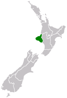
Taranaki
Encyclopedia
| Taranaki | |
| Country: | New Zealand New Zealand New Zealand is an island country in the south-western Pacific Ocean comprising two main landmasses and numerous smaller islands. The country is situated some east of Australia across the Tasman Sea, and roughly south of the Pacific island nations of New Caledonia, Fiji, and Tonga... |
 |
|
| Regional Council | |
|---|---|
| Name: | Taranaki Regional Council |
| Population: | |
| Land Area: | 7,257 km² |
| Chair: | David MacLeod |
| Deputy Chair: | David Lean David Lean Sir David Lean CBE was an English film director, producer, screenwriter, and editor best remembered for big-screen epics such as The Bridge on the River Kwai , Lawrence of Arabia ,... |
| Website: | http://www.trc.govt.nz/ |
| Tangata whenua Tangata Whenua Tāngata whenua is a Māori term of the indigenous peoples of New Zealand and literally means "people of the land", from tāngata, 'people' and whenua land.-Meanings:... |
|
| Local iwi Iwi In New Zealand society, iwi form the largest everyday social units in Māori culture. The word iwi means "'peoples' or 'nations'. In "the work of European writers which treat iwi and hapū as parts of a hierarchical structure", it has been used to mean "tribe" , or confederation of tribes,... |
Te Āti Awa Te Ati Awa Te Āti Awa is a Māori iwi with traditional bases in the Taranaki and Wellington regions of New Zealand. Approximately 17,000 people registered their affiliation to Te Āti Awa in 2001, with around 10,000 in Taranaki, 2,000 in Wellington and around 5,000 of unspecified regional location.-Geographical... , Ngā Rauru Nga Rauru Ngā Rauru is a Māori iwi in the Wanganui region of New Zealand. In the 2006 census, 4,047 Māori claimed affiliation to Ngā Rauru, representing 14 hapu.-Early history:... , Ngā Ruahine, Ngati Ruanui Ngati Ruanui Ngāti Ruanui is a Māori iwi traditionally based in the Taranaki region of New Zealand. In the 2006 census, 7,035 people claimed affiliation to the iwi. However, most members now live outside the traditional areas of the iwi.-Early history:... , Ngāti Maru Ngati Maru Ngāti Maru is a Māori iwi of New Zealand. There are two iwi known as Ngati Maru, one based in Taranaki, the other based in Thames . These two iwi have a common ancestor in Hotunui who had three sons Marukopiri, Maruwharanui and Marutūāhu... , Ngāti Mutunga Ngati Mutunga Ngāti Mutunga is a Māori iwi of New Zealand. Their tribal lands are in north Taranaki, with the principal marae being at Urenui.Prominent leader and anthropologist Te Rangi Hīroa was of Ngāti Mutunga descent.-External links:*... , Ngati Tama Pakakohi, Tangahoe, Taranaki |
| Cities and Towns | |
| Cities: | New Plymouth New Plymouth New Plymouth is the major city of the Taranaki Region on the west coast of the North Island of New Zealand. It is named after Plymouth, Devon, England, from where the first English settlers migrated.... |
| Towns, villages, and districts: | Ahititi Ahititi Ahititi is a locality in Taranaki, New Zealand. State Highway 3 runs through it. Mokau is 23 km to the north, Mimi is 26 km to the south-west, and Kotare is 16 km to the east. The Tongaporutu River flows through the area and into the North Taranaki Bight at Tongaporutu to the... , Alton Alton, New Zealand Alton is a small rural community in south Taranaki, in the western North Island of New Zealand. It is located between the towns of Hawera and Patea.-Business history:... , Auroa Auroa Auroa is a locality in southern Taranaki. Opunake is to the west, Kaponga to the northeast, and Manaia to the southeast. Mount Taranaki is directly north of Auroa.-Education:... , Awakino Awakino Awakino is a settlement in the south of Waitomo District, in the North Island of New Zealand. It is located on State Highway 3 at the mouth of the Awakino River, five kilometres north of Mokau. It is 79 km southwest of Te Kuiti, and 98 km northeast of New Plymouth.North of Awakino, State... , Bell Block Bell Block Bell Block is a town in Taranaki, New Zealand. State Highway 3 runs through it. It is 6 km north-east of the centre of New Plymouth and 1 km from the outer edge of New Plymouth at Waiwhakaiho. Waitara is about 9 km to the north-east... , Cardiff Cardiff, New Zealand Cardiff is a settlement in inland Taranaki, in the western North Island of New Zealand. It is located five kilometres southwest of Stratford close to Egmont National Park.-Business history:... , Douglas Douglas, Taranaki Douglas is a lowly populated locality and a rural centre in east Taranaki, surrounded by dairy, sheep and beef pastoral farming. It is situated 18 km east of Stratford at the intersection of East Road, Ohura Road, Douglas Road South and Bredow Road. East Road and Ohura Road meet to form State... , Eltham Eltham, New Zealand thumb|left|The town center of ElthamEltham is a small inland town in South Taranaki, New Zealand, located 50 km south of the city of New Plymouth and southeast of the volcanic cone of Mount Taranaki/Egmont. Stratford is 11 km north, Kaponga 13 km west, and Hawera 19 km south.... , Hawera Hawera Hawera is the second-largest town in the Taranaki region of New Zealand's North Island, with a population of . It is near the coast of the South Taranaki Bight, 75 kilometres south of New Plymouth on State Highway 3 and 20 minutes' drive from Mount Taranaki/Egmont.It is also on State Highway 45,... , Huiakama Huiakama Huiakama is a settlement in inland Taranaki, in the western North Island of New Zealand. It is located just to the north of Strathmore on State Highway 43.-Education:... , Huiroa Huiroa Huiroa is a settlement in inland Taranaki, in the western North Island of New Zealand. It is located 20 kilometres east of Stratford and eight kilometres north of Douglas.-Schools: Category:Stratford District... , Hurleyville Hurleyville Hurleyville is a community in south Taranaki, in the western North Island of New Zealand. It is located 18 kilometres north of Patea and 30 km southeast of Hawera.-Education:... , Inglewood Inglewood, New Zealand Inglewood is a town in the Taranaki Region of New Zealand's North Island. The population was 3,090 in the 2006 Census, an increase of 144 from 2001. Inglewood lies 200m above sea level.... , Kakaramea Kakaramea Kakaramea is a town in South Taranaki, New Zealand. State Highway 3 passes through it. Patea is about 6 km to the south-east, and Hawera is about 20 km to the north-west.-Education:... , Kaponga Kaponga Kaponga is a small town in the southern part of the Taranaki region of New Zealand. It is known as "The Gateway to Dawson's Falls" on Mount Taranaki/Egmont. Kaponga is located inland from Manaia and Eltham, and is on the main road connecting Eltham to Opunake. Opunaki is 26 km to the west and... , Kapuni Kapuni Kapuni is a small hydrocarbons field and drilling site in the North Island of New Zealand. It is located within a dairy farming area in Taranaki, south of New Plymouth.... , Lepperton Lepperton Lepperton is a small village in north Taranaki, New Zealand. It is approximately 6 km inland from Waitara township, 5 km west of the Waitara River, and 1 km east of State Highway 3A, which connects Inglewood to Waitara.... , Manaia, Mangatoki Mangatoki Mangatoki is a locality in southern Taranaki, in New Zealand's North Island. Eltham is to the east, Kaponga to the west and Matapu to the south. The Mangatoki Stream runs from Mount Taranaki/Egmont through the area and into the Waingongoro River.-Education:... , Mangorei Mangorei Mangorei is a locality on the outskirts of New Plymouth in Taranaki, New Zealand. The city centre is about 5 km to the north-west. State Highway 3 passes to the south-west.-Education:... , Midhirst Midhirst Midhirst is a small village in Taranaki, New Zealand, approximately 4 km north of Stratford, on State Highway 3. Inglewood is 17 km north of Midhirst, and New Plymouth is 35 km to the northwest.... , Mokau Mokau Mokau is a small town on the west coast of New Zealand's North Island, located at the mouth of the Mokau River on the North Taranaki Bight. Mokau lies just north of the boundary between the Taranaki Region and the Waikato Region... , Motunui Motunui Motunui is a settlement in northern Taranaki, in the North Island of New Zealand. It is located on State Highway 3 close to the shore of the North Taranaki Bight, six kilometres east of Waitara.... , Ngaere Ngaere Ngaere is a village situated on State Highway 3, 4 kilometres south of Stratford, New Zealand. The name Ngaere literally means "swamp" in English, and before settlement, the area was covered by a vast and ancient wetland.... , Ngamatapouri Ngamatapouri Ngamatapouri is a small rural locality in the Waitotara River valley, 47 km north of Waitotara village, in south Taranaki, New Zealand. Wanganui is about 80 km to the southeast. The road is sealed as far as the school.... , Normanby Normanby, Taranaki Normanby is a small village in South Taranaki, New Zealand. It is approximately 6 km inland from Hawera along State Highway 3. Eltham is 13 km further north... , Oakura Oakura Oakura is a small township in Taranaki, in the western North Island of New Zealand. It is located on State Highway 45, 15 kilometres south-west of New Plymouth. Okato is 12 km further south-west. The Oakura River flows past the town and into the North Taranaki Bight... , Oaonui Oaonui Oaonui is a community in the west of Taranaki, in the North Island of New Zealand. It is located on State Highway 45, eight kilometres north of Opunake.... , Ohangai Ohangai Ohangai is a locality in South Taranaki, New Zealand. It is approximately 10 km east of Hawera and 6 km north of Mokoia-Education:Ohangai School is a coeducational contributing primary school with a decile rating of 7 and a roll of 14. The school celebrated its centennial in 2006.... , Okato Okato Okato is a small township in rural Taranaki, New Zealand. The population was 531 in the 2006 Census, an increase of 12 from 2001. It is situated about 25 minutes drive around the coast from New Plymouth on State Highway 45. Oakura is 12 km to the north-east, and Warea is 9 km to the... , Omata Omata Omata is a locality in Taranaki, in the western North Island of New Zealand. It is located on State Highway 45 just southwest of New Plymouth.The population was 474 in the 2006 Census, an increase of 27 from 2001.... , Onaero Onaero Onaero is a settlement in northern Taranaki, in the North Island of New Zealand. It is located on State Highway 3 close to the shore of the North Taranaki Bight, 15 kilometres east of Waitara.-General historical works:... , Opunake Opunake Opunake is a small town on the southwest coast of Taranaki in New Zealand's North Island. It is located 45 kilometres southwest of New Plymouth. Rahotu is 16 km to the northwest. Manaia is 29 km to the southeast. State Highway 45 passes through the town.The population was 1368 in the... , Patea Patea Patea is the third-largest town in South Taranaki, New Zealand. It is on the western bank of the Patea River, 61 kilometres north-west of Wanganui on State Highway 3. Hawera is 27 km to the north-west, and Waverley 17 km to the east. The Patea River flows through the town from the... , Pungarehu Pungarehu Pungarehu is a small town located on Surf Highway 45 in Taranaki, New Zealand. Pungarehu is the home of the Cape Lighthouse, situated at Taranaki's westernmost point. The town centre is located almost 5 km from the coast line.... , Puniho Puniho Puniho is a community in the west of Taranaki, in the North Island of New Zealand. it is located on State Highway 45, 30 kilometres southwest of New Plymouth. Category:South Taranaki District... , Rahotu Rahotu Rahotu is a community in the west of Taranaki, in the North Island of New Zealand. It is located on State Highway 45, 16 kilometres north of Opunake and 11 km south of Warea.The population was 249 in the 2006 Census, a decrease of 48 from 2001.... , Ratapiko Ratapiko Ratapiko is a locality in Taranaki, New Zealand. Kaimata is about six kilometres to the north-west. Lake Ratapiko is just to the south-east of the locality.-Education:... , Rawhitiroa Rawhitiroa Rawhitiroa is a locality in South Taranaki, New Zealand. It is approximately 6.5 km east of Eltham.-Education:Rawhitiroa School is a coeducational full primary school with a decile rating of 6 and a roll of 49. The school opened on 11 December 1897, and was initially called Andersen Road School... , Stratford Stratford, New Zealand Stratford is the only town in the central Taranaki district of Stratford District, New Zealand. It lies beneath the eastern slopes of Mount Taranaki/Egmont, approximately half-way between New Plymouth and Hawera, near the geographic centre of the Taranaki region. The town has a population of... , Strathmore Strathmore, New Zealand Strathmore is a settlement in inland Taranaki, in the western North Island of New Zealand. It is located on State Highway 43, 25 kilometres east of Stratford.-General historical works: Category:Stratford District... , Te Popo Te Popo Te Popo is a settlement in inland Taranaki, in the western North Island of New Zealand. It is located ten kilometres northeast of Stratford.-Business history:... , Toko Toko Toko is a small rural settlement 10 kilometres east of Stratford, New Zealand, at the intersection of East Road and Toko Road. It is located on a railway, the Stratford - Okahukura Line, the western portion of which was operated as a branch line known as the Toko Branch prior to the line's... , Tongaporutu Tongaporutu Tongaporutu is a settlement in northern Taranaki, in the North Island of New Zealand. It is located on State Highway 3 at the mouth of the Tongaporutu River, 15 kilometres south of Mokau.Tongaporutu is well known in New Zealand for its 'Three Sisters' rock formations and its Maori petroglyphs... , Tututawa Tututawa Tututawa is a locality and rural centre in east Taranaki, New Zealand, 26 km east of Stratford, with a population of approximately 40. The settlement is centred 5 km south of Ohura Road , at the intersection of Mangaotuku Road and Tututawa Road. Positioned approximately 150m above sea level,... , Urenui Urenui Urenui is a settlement in northern Taranaki, in the North Island of New Zealand. It is located on State Highway 3 close to the shore of the North Taranaki Bight, 13 kilometres east of Waitara and 6 km south-west of Mimi... , Uruti Uruti Uruti is a locality in northern Taranaki, in the North Island of New Zealand. It is located on State Highway 3, north-east of Mimi and south-west of Ahititi. The Uruti Stream meets the Mimi River at this point. The river flows past the settlement into the North Taranaki Bight.A district nurse was... , Vogeltown Vogeltown, Taranaki Vogeltown is a suburb of New Plymouth, in the western North Island of New Zealand. It is located to the southeast of the city centre and east of Frankleigh Park. The suburb was named after Sir Julius Vogel, Prime Minister of New Zealand in the 1870s.... , Waipuku Waipuku Waipuku is a settlement in inland Taranaki, in the western North Island of New Zealand. It is located between Stratford and Inglewood on State Highway 3.-General historical works:... , Waitara Waitara, New Zealand Waitara is the name of a town and a river in the northern part of the Taranaki Region of the North Island of New Zealand. Waitara is located just off State Highway 3, 15 km northeast of New Plymouth.... , Waitoriki Waitoriki Waitoriki is a locality in Taranaki, New Zealand. Inglewood is about 4.5 km to the southwest.-Education:Waitoriki School is a coeducational full primary school with a decile rating of 4 and a roll of 21. The school began as the Wortley Road School in 1880.... , Warea Warea Warea is a community in the west of Taranaki, in the North Island of New Zealand. It is located on State Highway 45, 26 kilometres north of Opunake.-References:... , Waverley, Welbourn Welbourn Welbourn is a village in North Kesteven, central Lincolnshire on the A607 between Leadenham and Wellingore.-Village:The village church is St Chad's, part of the Loveden Deanery of the Diocese of Lincoln: the incumbent is the Revd Dr Alan Megahey.... , Westown Westown Westown is a suburb of New Plymouth, in the western North Island of New Zealand. It is located to the southwest of the city centre and west of Frankleigh Park.The population was 3,399 in the 2006 Census, an increase of 108 from 2001.... , Whenuakura Whenuakura Whenuakura is a farming community on State Highway 3 east of Patea, at the southern end of Taranaki on the North Island of New Zealand. The boundary between the Taranaki and Wellington provinces runs through Whenuakura. There is the Whenuakura Primary School, Whenuakura dairy factory and Whenuakura... |
| Territorial Authorities | |
| Names: | New Plymouth District Council Stratford District Council (part) South Taranaki District Council South Taranaki District South Taranaki is a territorial authority on the west coast of New Zealand's North Island that contains the towns of Hawera, Manaia, Opunake, Patea, Eltham, and Waverley... |
| Websites: | http://www.stratford.govt.nz http://www.newplymouthnz.com http://www.stdc.govt.nz |
Taranaki is a region in the west of New Zealand
New Zealand
New Zealand is an island country in the south-western Pacific Ocean comprising two main landmasses and numerous smaller islands. The country is situated some east of Australia across the Tasman Sea, and roughly south of the Pacific island nations of New Caledonia, Fiji, and Tonga...
's North Island
North Island
The North Island is one of the two main islands of New Zealand, separated from the much less populous South Island by Cook Strait. The island is in area, making it the world's 14th-largest island...
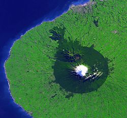
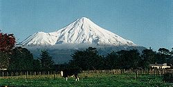
and is the 10th largest region of New Zealand by population. It is named for the region's main geographical feature, Mount Taranaki
Mount Taranaki
Mount Taranaki, or Mount Egmont, is an active but quiescent stratovolcano in the Taranaki region on the west coast of New Zealand's North Island. Although the mountain is more commonly referred to as Taranaki, it has two official names under the alternative names policy of the New Zealand...
.
The main centre of the Taranaki region is the city of New Plymouth
New Plymouth
New Plymouth is the major city of the Taranaki Region on the west coast of the North Island of New Zealand. It is named after Plymouth, Devon, England, from where the first English settlers migrated....
which has been voted the "Top City" in New Zealand. The New Plymouth District has over 60% of the entire population of Taranaki. New Plymouth is located in North Taranaki along with Inglewood
Inglewood, New Zealand
Inglewood is a town in the Taranaki Region of New Zealand's North Island. The population was 3,090 in the 2006 Census, an increase of 144 from 2001. Inglewood lies 200m above sea level....
and Waitara
Waitara, New Zealand
Waitara is the name of a town and a river in the northern part of the Taranaki Region of the North Island of New Zealand. Waitara is located just off State Highway 3, 15 km northeast of New Plymouth....
. South Taranaki towns include Hawera
Hawera
Hawera is the second-largest town in the Taranaki region of New Zealand's North Island, with a population of . It is near the coast of the South Taranaki Bight, 75 kilometres south of New Plymouth on State Highway 3 and 20 minutes' drive from Mount Taranaki/Egmont.It is also on State Highway 45,...
, Stratford
Stratford, New Zealand
Stratford is the only town in the central Taranaki district of Stratford District, New Zealand. It lies beneath the eastern slopes of Mount Taranaki/Egmont, approximately half-way between New Plymouth and Hawera, near the geographic centre of the Taranaki region. The town has a population of...
and Eltham
Eltham, New Zealand
thumb|left|The town center of ElthamEltham is a small inland town in South Taranaki, New Zealand, located 50 km south of the city of New Plymouth and southeast of the volcanic cone of Mount Taranaki/Egmont. Stratford is 11 km north, Kaponga 13 km west, and Hawera 19 km south....
.
Since 2005, Taranaki has used the promotional brand "Like no other".
Geography and people
Cape Egmont
Cape Egmont is the westernmost point of Taranaki, on the west coast of New Zealand's North Island. It is located close to the volcanic cone of Mount Taranaki or Mount Egmont....
are prosaically named the North Taranaki Bight
North Taranaki Bight
The North Taranaki Bight is the name given to the large bay which extends north and east from the north coast of Taranaki in New Zealand's North Island. The name is echoed by the South Taranaki Bight to the south of Cape Egmont....
and the South Taranaki Bight
South Taranaki Bight
The South Taranaki Bight is the name given to the large bay which extends south and east from the south coast of Taranaki in New Zealand's North Island. With more symmetry than poetry or originality, it is matched by the North Taranaki Bight to the north of Cape Egmont.The size of the bight...
.
Maori language
Māori or te reo Māori , commonly te reo , is the language of the indigenous population of New Zealand, the Māori. It has the status of an official language in New Zealand...
—is the dominant feature of the region, second-tallest mountain in the North Island
North Island
The North Island is one of the two main islands of New Zealand, separated from the much less populous South Island by Cook Strait. The island is in area, making it the world's 14th-largest island...
. Māori legend
Mount Taranaki legend
In Māori legend, Taranaki is a mountain being that lived peacefully for many centuries in the centre of New Zealand's North Island with three other mountains, Tongariro, Ngauruhoe and Ruapehu.Nearby stood Mount Pihanga...
says that Taranaki previously lived with the Tongariro
Mount Tongariro
Mount Tongariro is a volcanic complex in the North Island of New Zealand. It is located 20 kilometres to the southwest of Lake Taupo, and is the northernmost of the three active volcanoes that dominate the landscape of the central North Island....
, Ngauruhoe
Mount Ngauruhoe
Mount Ngauruhoe is an active stratovolcano or composite cone in New Zealand, made from layers of lava and tephra. It is the youngest vent in the Tongariro volcanic complex on the Central Plateau of the North Island, and first erupted about 2,500 years ago...
and Ruapehu
Mount Ruapehu
Mount Ruapehu, or just Ruapehu, is an active stratovolcano at the southern end of the Taupo Volcanic Zone in New Zealand. It is 23 kilometres northeast of Ohakune and 40 kilometres southwest of the southern shore of Lake Taupo, within Tongariro National Park...
mountains of the central North Island but fled to its current location after a battle with Tongariro.
Taranaki, a near-perfect cone, last erupted in the mid-18th century. The mountain and its immediate surrounds form Egmont National Park
Egmont National Park
Egmont National Park is located south of New Plymouth, close to the west coast of the North Island of New Zealand. It is named after the mountain which dominates its environs, which itself was named by Captain Cook after John Perceval, 2nd Earl of Egmont, the First Lord of the Admiralty who...
.
Although Māori had called the mountain Taranaki for many centuries, Captain James Cook
James Cook
Captain James Cook, FRS, RN was a British explorer, navigator and cartographer who ultimately rose to the rank of captain in the Royal Navy...
re-named it Egmont after the Earl of Egmont
John Perceval, 2nd Earl of Egmont
John Perceval, 2nd Earl of Egmont PC, FRS was a British politician, political pamphleteer, and genealogist...
the recently retired First Lord of the Admiralty who had encouraged his expedition. The mountain has two alternative official names, "Mount Taranaki" and "Mount Egmont".
The region has an area of 7258 km² and a population of Just under half live in the city of New Plymouth
New Plymouth
New Plymouth is the major city of the Taranaki Region on the west coast of the North Island of New Zealand. It is named after Plymouth, Devon, England, from where the first English settlers migrated....
. Other centres include Waitara
Waitara, New Zealand
Waitara is the name of a town and a river in the northern part of the Taranaki Region of the North Island of New Zealand. Waitara is located just off State Highway 3, 15 km northeast of New Plymouth....
, Inglewood
Inglewood, New Zealand
Inglewood is a town in the Taranaki Region of New Zealand's North Island. The population was 3,090 in the 2006 Census, an increase of 144 from 2001. Inglewood lies 200m above sea level....
, Stratford
Stratford, New Zealand
Stratford is the only town in the central Taranaki district of Stratford District, New Zealand. It lies beneath the eastern slopes of Mount Taranaki/Egmont, approximately half-way between New Plymouth and Hawera, near the geographic centre of the Taranaki region. The town has a population of...
, Opunake, Okato
Okato
Okato is a small township in rural Taranaki, New Zealand. The population was 531 in the 2006 Census, an increase of 12 from 2001. It is situated about 25 minutes drive around the coast from New Plymouth on State Highway 45. Oakura is 12 km to the north-east, and Warea is 9 km to the...
, Kaponga
Kaponga
Kaponga is a small town in the southern part of the Taranaki region of New Zealand. It is known as "The Gateway to Dawson's Falls" on Mount Taranaki/Egmont. Kaponga is located inland from Manaia and Eltham, and is on the main road connecting Eltham to Opunake. Opunaki is 26 km to the west and...
, Eltham
Eltham, New Zealand
thumb|left|The town center of ElthamEltham is a small inland town in South Taranaki, New Zealand, located 50 km south of the city of New Plymouth and southeast of the volcanic cone of Mount Taranaki/Egmont. Stratford is 11 km north, Kaponga 13 km west, and Hawera 19 km south....
, Hawera
Hawera
Hawera is the second-largest town in the Taranaki region of New Zealand's North Island, with a population of . It is near the coast of the South Taranaki Bight, 75 kilometres south of New Plymouth on State Highway 3 and 20 minutes' drive from Mount Taranaki/Egmont.It is also on State Highway 45,...
, Patea
Patea
Patea is the third-largest town in South Taranaki, New Zealand. It is on the western bank of the Patea River, 61 kilometres north-west of Wanganui on State Highway 3. Hawera is 27 km to the north-west, and Waverley 17 km to the east. The Patea River flows through the town from the...
and Waverley—the southern-most town.
The region has had a strong Māori presence for centuries. The local iwi
Iwi
In New Zealand society, iwi form the largest everyday social units in Māori culture. The word iwi means "'peoples' or 'nations'. In "the work of European writers which treat iwi and hapū as parts of a hierarchical structure", it has been used to mean "tribe" , or confederation of tribes,...
(tribes) include Ngāti Mutunga
Ngati Mutunga
Ngāti Mutunga is a Māori iwi of New Zealand. Their tribal lands are in north Taranaki, with the principal marae being at Urenui.Prominent leader and anthropologist Te Rangi Hīroa was of Ngāti Mutunga descent.-External links:*...
, Ngāti Maru
Ngati Maru
Ngāti Maru is a Māori iwi of New Zealand. There are two iwi known as Ngati Maru, one based in Taranaki, the other based in Thames . These two iwi have a common ancestor in Hotunui who had three sons Marukopiri, Maruwharanui and Marutūāhu...
, Ngāti Ruanui
Ngati Ruanui
Ngāti Ruanui is a Māori iwi traditionally based in the Taranaki region of New Zealand. In the 2006 census, 7,035 people claimed affiliation to the iwi. However, most members now live outside the traditional areas of the iwi.-Early history:...
, Taranaki, Te Āti Awa
Te Ati Awa
Te Āti Awa is a Māori iwi with traditional bases in the Taranaki and Wellington regions of New Zealand. Approximately 17,000 people registered their affiliation to Te Āti Awa in 2001, with around 10,000 in Taranaki, 2,000 in Wellington and around 5,000 of unspecified regional location.-Geographical...
, Nga Rauru
Nga Rauru
Ngā Rauru is a Māori iwi in the Wanganui region of New Zealand. In the 2006 census, 4,047 Māori claimed affiliation to Ngā Rauru, representing 14 hapu.-Early history:...
, Ngāruahinerangi and Ngāti Tama.
Dairy farming
Dairy farming is a class of agricultural, or an animal husbandry, enterprise, for long-term production of milk, usually from dairy cows but also from goats and sheep, which may be either processed on-site or transported to a dairy factory for processing and eventual retail sale.Most dairy farms...
predominates, with the milk factory just outside Hawera being the second largest in the Southern Hemisphere
Southern Hemisphere
The Southern Hemisphere is the part of Earth that lies south of the equator. The word hemisphere literally means 'half ball' or "half sphere"...
. There are also oil and gas deposits in the region, both on- and off-shore. The Maui gas field
Maui gas field
The Maui natural gas field is the largest gas, natural gas condensate and oil field in New Zealand, producing nearly three-quarters of the country's hydrocarbons, as well as providing energy for electricity generation. It is located in the Tasman Sea, 35 km off the coast of Taranaki and to the...
off the south-west coast has provided most of New Zealand's gas supply as well as, at one time supporting two methanol
Methanol
Methanol, also known as methyl alcohol, wood alcohol, wood naphtha or wood spirits, is a chemical with the formula CH3OH . It is the simplest alcohol, and is a light, volatile, colorless, flammable liquid with a distinctive odor very similar to, but slightly sweeter than, ethanol...
plants (one formerly a synthetic-petrol plant called the Gas-To-Gasolene plant) at Motunui
Motunui
Motunui is a settlement in northern Taranaki, in the North Island of New Zealand. It is located on State Highway 3 close to the shore of the North Taranaki Bight, six kilometres east of Waitara....
. More fuel and fertilizer is produced from a well-complex at Kapuni
Kapuni
Kapuni is a small hydrocarbons field and drilling site in the North Island of New Zealand. It is located within a dairy farming area in Taranaki, south of New Plymouth....
and a number of smaller land-based oilfields. With the Maui field nearing depletion, new offshore resources have been developed: The Tui field, 50 km south of Hawera, with reserves of 50000000 barrels (7,949,364,750 l) of oil and the Pohokura gas field
Pohokura field
The Pohokura field is an oil and gas field located 4 km offshore of north Taranaki in New Zealand, in approximately 30 m of water. The field was discovered in 2000 by Fletcher Challenge and has total estimated reserves of 996 Bcf of gas and 59.4 mmbbls of condensate.The field has 6 offshore and 3...
, 4.5 km north of Waitara.
The way the land mass projects into the Tasman Sea
Tasman Sea
The Tasman Sea is the large body of water between Australia and New Zealand, approximately across. It extends 2,800 km from north to south. It is a south-western segment of the South Pacific Ocean. The sea was named after the Dutch explorer Abel Janszoon Tasman, the first recorded European...
with northerly, westerly and southerly exposures results in many excellent surfing and windsurfing locations, some of them considered world-class.
Economy
The sub-national GDP of the Taranaki region was estimated at US$4.4 billion in 2003, 3% of New Zealand's national GDP.History
The area became home to a number of Māori tribes from the 13th century. From about 1823 the Māori began having contact with European whalerWhaler
A whaler is a specialized ship, designed for whaling, the catching and/or processing of whales. The former included the whale catcher, a steam or diesel-driven vessel with a harpoon gun mounted at its bows. The latter included such vessels as the sail or steam-driven whaleship of the 16th to early...
s as well as traders who arrived by schooner
Schooner
A schooner is a type of sailing vessel characterized by the use of fore-and-aft sails on two or more masts with the forward mast being no taller than the rear masts....
to buy flax
New Zealand flax
New Zealand flax describes common New Zealand perennial plants Phormium tenax and Phormium cookianum, known by the Māori names harakeke and wharariki respectively...
. In March 1828 Richard "Dicky" Barrett
Dicky Barrett (trader)
Richard "Dicky" Barrett was one of the first white traders to be based in New Zealand. He lent his translation skills to help negotiate the first land purchases from Maori in New Plymouth and Wellington and became a key figure in the establishment of the settlement of New Plymouth...
(1807–47) set up a trading post at Ngamotu (present-day New Plymouth
New Plymouth
New Plymouth is the major city of the Taranaki Region on the west coast of the North Island of New Zealand. It is named after Plymouth, Devon, England, from where the first English settlers migrated....
). Barrett and his companions, who were armed with muskets and cannon, were welcomed by the Āti Awa tribe because of their worth assisting in their continuing wars with Waikato
Waikato
The Waikato Region is a local government region of the upper North Island of New Zealand. It covers the Waikato, Hauraki, Coromandel Peninsula, the northern King Country, much of the Taupo District, and parts of Rotorua District...
Māori ,. Following a bloody encounter at Ngamotu in 1832, most of the 2000 Āti Awa living near Ngamotu, as well as Barrett, migrated south to the Kapiti
Kapiti Coast
The Kapiti Coast is the name of the section of the coast of the south-western North Island of New Zealand that is north of Wellington and opposite Kapiti Island. It falls under the jurisdiction of the Wellington Regional Council...
region and Marlborough.
In late 1839 Barrett returned to Taranaki to act as a purchasing agent for the New Zealand Company
New Zealand Company
The New Zealand Company originated in London in 1837 as the New Zealand Association with the aim of promoting the "systematic" colonisation of New Zealand. The association, and later the company, intended to follow the colonising principles of Edward Gibbon Wakefield, who envisaged the creation of...
, which had already begun on-selling the land to prospective settlers in England with the expectation of securing its title. Barrett claimed to have negotiated the purchase of an area extending from Mokau
Mokau
Mokau is a small town on the west coast of New Zealand's North Island, located at the mouth of the Mokau River on the North Taranaki Bight. Mokau lies just north of the boundary between the Taranaki Region and the Waikato Region...
to Cape Egmont
Cape Egmont
Cape Egmont is the westernmost point of Taranaki, on the west coast of New Zealand's North Island. It is located close to the volcanic cone of Mount Taranaki or Mount Egmont....
, and inland to the upper reaches of the Whanganui River
Whanganui River
The Whanganui River is a major river in the North Island of New Zealand.Known for many years as the Wanganui River, the river's name reverted to Whanganui in 1991, according with the wishes of local iwi. Part of the reason was also to avoid confusion with the Wanganui River in the South Island...
including Mt Taranaki. A later deed of sale included New Plymouth and all the coastal lands of North Taranaki, including Waitara
Waitara, New Zealand
Waitara is the name of a town and a river in the northern part of the Taranaki Region of the North Island of New Zealand. Waitara is located just off State Highway 3, 15 km northeast of New Plymouth....
.
European settlement at New Plymouth began with the arrival of the William Bryan in March 1841.In mid 1842 the whole of North Taranaki,northward of Cape Egmont , was sold to the government by Te Wherowhero the great Waikato chief,(who later became the first Maori King) who had conquered the land to establish his mana. The land was sold for 250 pounds,2 horses ,2 saddles,2 bridles and 100 blankets.The deed of sale was written in both English and Maori and included Waitara. European expansion beyond New Plymouth, however, was prevented by some Māori opposition to selling their land, a sentiment that deepened as links strengthened with the King Movement. Tension over land ownership continued to mount, leading to the outbreak of war
First Taranaki War
The First Taranaki War was an armed conflict over land ownership and sovereignty that took place between Māori and the New Zealand Government in the Taranaki district of New Zealand's North Island from March 1860 to March 1861....
at Waitara in March 1860. Although the sale of the Waitara block resulted from the offer of a minor chief to sell his land , the greater issue fuelling the conflict was the Government's desire to impose British sovereignty in the form of administration, law and civilisation on the Māori.
The war in Taranaki was fought by more than 3500 imperial troops brought in from Australia
Australia
Australia , officially the Commonwealth of Australia, is a country in the Southern Hemisphere comprising the mainland of the Australian continent, the island of Tasmania, and numerous smaller islands in the Indian and Pacific Oceans. It is the world's sixth-largest country by total area...
, as well as volunteer soldiers and militia, against Māori forces that fluctuated between a few hundred and about 1500. Total losses among the imperial, volunteer and militia troops are estimated to have been 238, while Māori casualties totalled about 200.
An uneasy truce was negotiated a year later, only to be broken in April 1863 as tensions over land occupation boiled over again. A total of 5000 troops fought in the Second Taranaki War
Second Taranaki War
-Background and causes of the war:The conflict in Taranaki had its roots in the First Taranaki War, which had ended in March 1861 with an uneasy truce. Neither side fulfilled the terms of the truce, leaving many of the issues unresolved...
against about 1500 men, women and children. The style of warfare differed markedly from that of the 1860–61 conflict as the army systematically took possession of Māori land by driving off the inhabitants, adopting a "scorched earth
Scorched earth
A scorched earth policy is a military strategy or operational method which involves destroying anything that might be useful to the enemy while advancing through or withdrawing from an area...
" strategy of laying waste to the villages and cultivations of Māori, whether warlike or otherwise. As the troops advanced, the Government built an expanding line of redoubts, behind which settlers built homes and developed farms. The effect was a creeping confiscation of almost a million acres (4,000 km²) of land.
The present main highway on the inland side of Mount Taranaki
Mount Taranaki
Mount Taranaki, or Mount Egmont, is an active but quiescent stratovolcano in the Taranaki region on the west coast of New Zealand's North Island. Although the mountain is more commonly referred to as Taranaki, it has two official names under the alternative names policy of the New Zealand...
follows the path taken by the colonial forces under Major General Trevor Chute
Trevor Chute
Major-General Sir Trevor Chute KCB, 31 July 1816 – 12 March 1886 , was an Irish soldier in the British army, whose six week campaign during the Second Taranaki War was the last to be carried out in New Zealand by imperial troops.-Family Background:...
as they marched, with great difficulty, from Patea
Patea
Patea is the third-largest town in South Taranaki, New Zealand. It is on the western bank of the Patea River, 61 kilometres north-west of Wanganui on State Highway 3. Hawera is 27 km to the north-west, and Waverley 17 km to the east. The Patea River flows through the town from the...
to New Plymouth in 1866.
Armed Māori resistance continued in South Taranaki until early 1869, led by the warrior Titokowaru
Titokowaru
Riwha Titokowaru became a Māori leader in the Taranaki region and one of the most successful opponents of British colonisation anywhere....
, who reclaimed land almost as far south as Wanganui
Wanganui
Whanganui , also spelled Wanganui, is an urban area and district on the west coast of the North Island of New Zealand. It is part of the Manawatu-Wanganui region....
. A decade later spiritual leader Te Whiti o Rongomai
Te Whiti o Rongomai
Te Whiti o Rongomai III was a Māori spiritual leader and founder of the village of Parihaka, in New Zealand's Taranaki region.-Biography:...
, based at Parihaka
Parihaka
Parihaka is a small community in Taranaki Region, New Zealand, located between Mount Taranaki and the Tasman Sea. In the 1870s and 1880s the settlement, then reputed to be the largest Māori village in New Zealand, became the centre of a major campaign of non-violent resistance to European...
, launched a campaign of passive resistance against government land confiscation, which culminated in a brutal raid by colonial troops on November 5, 1881.
The confiscations, subsequently acknowledged by the New Zealand Government as unjust and illegal, began in 1865 and soon included the entire Taranaki district. Towns including Normanby
Normanby, Taranaki
Normanby is a small village in South Taranaki, New Zealand. It is approximately 6 km inland from Hawera along State Highway 3. Eltham is 13 km further north...
, Hawera
Hawera
Hawera is the second-largest town in the Taranaki region of New Zealand's North Island, with a population of . It is near the coast of the South Taranaki Bight, 75 kilometres south of New Plymouth on State Highway 3 and 20 minutes' drive from Mount Taranaki/Egmont.It is also on State Highway 45,...
and Carlyle (Patea
Patea
Patea is the third-largest town in South Taranaki, New Zealand. It is on the western bank of the Patea River, 61 kilometres north-west of Wanganui on State Highway 3. Hawera is 27 km to the north-west, and Waverley 17 km to the east. The Patea River flows through the town from the...
) were established on land confiscated as military settlements. The release of a Waitangi Tribunal
Waitangi Tribunal
The Waitangi Tribunal is a New Zealand permanent commission of inquiry established under the Treaty of Waitangi Act 1975...
report on the situation in 1996 led to some debate on the matter. In a speech to a group of psychologists, Associate Minister of Māori Affairs Tariana Turia compared the suppression of Taranaki Māori to the Holocaust, provoking a vigorous reaction around New Zealand, with Prime Minister Helen Clark
Helen Clark
Helen Elizabeth Clark, ONZ is a New Zealand political figure who was the 37th Prime Minister of New Zealand for three consecutive terms from 1999 to 2008...
among those voicing criticism.
Provincial Government
From 1853 the Taranaki region was governed as the Taranaki ProvinceTaranaki Province
The Taranaki Province was a province of New Zealand from 1853 until the abolition of provincial government in 1876...
, (initially known as the New Plymouth Province) until the abolition of New Zealand provinces
Provinces of New Zealand
The Provinces of New Zealand existed from 1841 until 1876 as a form of sub-national government. They were replaced by counties, which were themselves replaced by districts.Following abolition, the provinces became known as provincial districts...
in 1876. The leading office was that of the superintendent.
The following is a list of superintendents of the Province of Taranaki during this time:
| Superintendent | Term |
|---|---|
| Charles Brown Charles Brown (Taranaki) Charles Brown was a New Zealand politician from the Taranaki area.-Personal life:Brown was born in London, England, the illegitimate son of Charles Armitage Brown and Abigail O'Donohue, an Irish house servant at Wentworth Place where Brown and Keats resided... |
1853–1857 |
| George Cutfield | 1857–1861 |
| Charles Brown Charles Brown (Taranaki) Charles Brown was a New Zealand politician from the Taranaki area.-Personal life:Brown was born in London, England, the illegitimate son of Charles Armitage Brown and Abigail O'Donohue, an Irish house servant at Wentworth Place where Brown and Keats resided... |
1861–1865 |
| Henry Robert Richmond Henry Robert Richmond Henry Robert Richmond was a 19th century New Zealand politician and farmer, and brother of James Crowe Richmond and William Richmond. They were part of the Richmond-Atkinson family of Taranaki who were all related by marriage.... |
1865–1869 |
| Frederic Alonzo Carrington Frederic Alonzo Carrington Frederick Alonzo Carrington was a 19th century New Zealand politician and surveyor. He was born in Chelmsford, Essex, England in 1807 or 1808, the son of Captain William Carrington. He was 15 years in the Ordnance Survey Department... |
1869–1876 |
Taranaki Regional Council
The Taranaki Regional Council was formed as part of major nationwide local governmentLocal government
Local government refers collectively to administrative authorities over areas that are smaller than a state.The term is used to contrast with offices at nation-state level, which are referred to as the central government, national government, or federal government...
reforms in November 1989, for the purpose of Integrated catchment management
Integrated catchment management
Integrated catchment management is a subset of environmental planning which approaches sustainable resource management from a catchment perspective, in contrast to a piecemeal approach that artificially separates land management from water management....
. The regional council was the successor to the Taranaki Catchment Board, the Taranaki United Council, the Taranaki Harbours Board, and 16 small special-purpose local bodies that were abolished under the Local Government Amendment Act (No 3) 1988. The Council's headquarters were established in the central location of Stratford
Stratford, New Zealand
Stratford is the only town in the central Taranaki district of Stratford District, New Zealand. It lies beneath the eastern slopes of Mount Taranaki/Egmont, approximately half-way between New Plymouth and Hawera, near the geographic centre of the Taranaki region. The town has a population of...
to "provide a good compromise in respect of overcoming traditional south vs north Taranaki community of interest conflicts" (Taranaki Regional Council, 2001 p. 6).
Functions
The Council operates under the Resource Management ActResource Management Act
The Resource Management Act passed in 1991 in New Zealand is a significant, and at times, controversial Act of Parliament. The RMA promotes the sustainable management of natural and physical resources such as land, air and water...
mandate of sustainable management
Sustainable management
Sustainable management takes the concepts from sustainability and synthesizes them with the concepts of management. Sustainability has three branches: the environment, the needs of present and future generations, and the economy...
, and carries out the following functions:
- PolicyPolicyA policy is typically described as a principle or rule to guide decisions and achieve rational outcome. The term is not normally used to denote what is actually done, this is normally referred to as either procedure or protocol...
and planningPlanningPlanning in organizations and public policy is both the organizational process of creating and maintaining a plan; and the psychological process of thinking about the activities required to create a desired goal on some scale. As such, it is a fundamental property of intelligent behavior... - Civil defence emergency managementEmergency managementEmergency management is the generic name of an interdisciplinary field dealing with the strategic organizational management processes used to protect critical assets of an organization from hazard risks that can cause events like disasters or catastrophes and to ensure the continuance of the...
- Resource consentResource consentA resource consent is the authorisation given to certain activities or uses of natural and physical resources required under the New Zealand Resource Management Act . Some activities may either be specifically authorised by the RMA or be permitted activities authorised by rules in plans...
s - Land managementLand managementLand management is the process of managing the use and development of land resources. Land resources are used for a variety of purposes which may include organic agriculture, reforestation, water resource management and eco-tourism projects.-See also:*Sustainable land management*Acreage...
- River control and flood protection
- Land transportLand transportLand transport created by Barry Land is a family company shipping general freight between Perth,Adelaide, Melbourne, Wagga Wagga,Dubbo,Tamworth, Moree, Toowoomba and Brisbane.Many other services available upon request....
and harbour management - Resource investigations, monitoring and enhancement
- Pest management
- RecreationRecreationRecreation is an activity of leisure, leisure being discretionary time. The "need to do something for recreation" is an essential element of human biology and psychology. Recreational activities are often done for enjoyment, amusement, or pleasure and are considered to be "fun"...
, cultureCultureCulture is a term that has many different inter-related meanings. For example, in 1952, Alfred Kroeber and Clyde Kluckhohn compiled a list of 164 definitions of "culture" in Culture: A Critical Review of Concepts and Definitions...
and heritageCultural heritageCultural heritage is the legacy of physical artifacts and intangible attributes of a group or society that are inherited from past generations, maintained in the present and bestowed for the benefit of future generations... - Regional representation, information and investments
Chairmen
- Ross Leslie AllenRoss Leslie AllenRoss Leslie Allen, commonly called Ross Allen, is a retired New Zealand politician who served as the first chairman of Taranaki Regional Council from 1989 to 2001. He was involved in local government for 27 years, beginning in 1974 when he was elected as a member of Taranaki County Council...
(1989–2001) - David WalterDavid WalterDavid Ernest Walter is the immediate past Chairman of Taranaki Regional Council, past Chairman of Stratford County Council, and the first Mayor of Stratford District Council.-Family background:Walter was born in Douglas, Taranaki...
(2001–2007) - David MacLeod (2007–)
Placenames in Taranaki
The Māori languageMaori language
Māori or te reo Māori , commonly te reo , is the language of the indigenous population of New Zealand, the Māori. It has the status of an official language in New Zealand...
spoken in Taranaki replaces the sound of h (both on its own and in wh) with a break. (The sound used in adjacent Wanganui
Wanganui
Whanganui , also spelled Wanganui, is an urban area and district on the west coast of the North Island of New Zealand. It is part of the Manawatu-Wanganui region....
is similar but not identical.) Thus the famous elder Hina Okeroa was universally known as Ina. The name of the river flowing through New Plymouth
New Plymouth
New Plymouth is the major city of the Taranaki Region on the west coast of the North Island of New Zealand. It is named after Plymouth, Devon, England, from where the first English settlers migrated....
, Waiwakaiho, would be written wai whakaiho (meaning "water flowing downward") in Central North Island Māori.
Notable people
- Sir Peter Buck (Te Rangi Hīroa) of Ngāti MutungaNgati MutungaNgāti Mutunga is a Māori iwi of New Zealand. Their tribal lands are in north Taranaki, with the principal marae being at Urenui.Prominent leader and anthropologist Te Rangi Hīroa was of Ngāti Mutunga descent.-External links:*...
– Māori scholar, born in Urenui - Michael CampbellMichael CampbellMichael Shane Campbell, CNZM is a New Zealand golfer who is best known for having won the 2005 U.S. Open and the richest prize in golf, the £1,000,000 HSBC World Match Play Championship, in the same year. He is a member of the European Tour.Ethnically, he is predominantly Māori, from the Ngati...
– golfer - William Douglas CookWilliam Douglas CookWilliam Douglas Cook was the founder of Eastwoodhill Arboretum, now the national arboretum of New Zealand, and one of the founders of Pukeiti, a rhododendron garden, close to New Plymouth...
(New Plymouth, 1884 – GisborneGisborne, New Zealand-Economy:The harbour was host to many ships in the past and had developed as a river port to provide a more secure location for shipping compared with the open roadstead of Poverty Bay which can be exposed to southerly swells. A meat works was sited beside the harbour and meat and wool was shipped...
, 1967) – founder of Eastwoodhill ArboretumEastwoodhill ArboretumEastwoodhill is the national arboretum of New Zealand. It covers and is located 35 km northwest of Gisborne, in the hill country of Ngatapa. It was founded in 1910 by William Douglas Cook...
, Ngatapa, GisborneGisborne, New Zealand-Economy:The harbour was host to many ships in the past and had developed as a river port to provide a more secure location for shipping compared with the open roadstead of Poverty Bay which can be exposed to southerly swells. A meat works was sited beside the harbour and meat and wool was shipped...
and of Pukeiti, world famous rhododendronRhododendronRhododendron is a genus of over 1 000 species of woody plants in the heath family, most with showy flowers...
garden, New Plymouth. - Grant FoxGrant FoxGrant James Fox is a former rugby union player from New Zealand. He was born in New Plymouth. He attended Auckland Grammar school....
– Former All Black fly-half, born in New Plymouth - Paige HarebPaige HarebPaige Frances Hareb is a professional surfer from Oakura Beach, New Zealand. In December 2008 she became the first New Zealand woman to qualify for the ASP Women's World Tour....
– professional surfer - Graham Kirk – artist
- Len LyeLen LyeLen Lye, born Leonard Charles Huia Lye , was a Christchurch, New Zealand-born artist known primarily for his experimental films and kinetic sculpture. His films are held in archives such as the New Zealand Film Archive, British Film Institute, Museum of Modern Art in New York City, and the Pacific...
– artist, filmmaker Born in Christchurch, collection only housed in New Plymouth. - Melanie LynskeyMelanie LynskeyMelanie Jayne Lynskey is a New Zealand actress best known for playing Charlie Harper's neighbor/stalker Rose on Two and a Half Men, and a range of characters in films such as Win Win, Up in the Air, The Informant!, Away We Go, Flags of Our Fathers, Shattered Glass, Sweet Home Alabama, Ever After...
– actress - Luke McAlisterLuke McAlisterCharles Luke McAlister is a New Zealand rugby union footballer. He plays first five-eighths and second five-eighths ....
– New Zealand All Blacks - Graham MourieGraham MourieGraham Neil Kenneth Mourie is a former New Zealand All Black flanker and coach of the Hurricanes. He was one of the great All Black Captains in the late 70s and early 80s...
– former All Black captain - William Malone – First World War officer
- Darcy Nicholas – artist
- Conrad SmithConrad SmithConrad Gerard Smith is a New Zealand rugby union footballer. He is a midfield back and plays outside centre . He had been in many Taranaki age group teams. He moved to Wellington where he completed an LLB at Victoria University of Wellington...
– Current All Black centre, born in Hawera and went to Francis Douglas Memorial College - Michael SmitherMichael SmitherMichael Duncan Smither, CNZM is a New Zealand painter and composer.He was born in New Plymouth and was educated at New Plymouth Boys' High School and Elam School of Fine Arts, Auckland...
– artist - Peter SnellPeter SnellSir Peter George Snell, KNZM, MBE is a former New Zealand athlete, now resident in Texas, United States. He had one of the shortest careers of world famous international sportsmen, yet achieved so much that he was voted New Zealand’s "Sports Champion of the Century"...
– Gold medal winning athlete, born in Opunake - Ronald SymeRonald SymeSir Ronald Syme, OM, FBA was a New Zealand-born historian and classicist. Long associated with Oxford University, he is widely regarded as the 20th century's greatest historian of ancient Rome...
– scholar of ancient history - Isaac Luke – South Sydney RabbitohsSouth Sydney RabbitohsThe South Sydney Rabbitohs are an Australian professional rugby league football team based in Redfern, a suburb of South-central Sydney, New South Wales. They participate in the National Rugby League premiership and are one of nine existing teams from the state capital...
and New Zealand rugby leagueNew Zealand Rugby LeagueThe New Zealand Rugby League is the governing body for the sport of rugby league football in New Zealand. The NZRL was founded on the 25 April 1910 in preparation for a tour of Great Britain that same year....
international
Further reading
- J. S. Tullett (1981). The Industrious Heart: A History of New Plymouth. New Plymouth District Council
- Belich, JamesJames Belich (historian)James Christopher Belich, ONZM is a New Zealand revisionist historian, known for his work on the New Zealand Wars.Of Croatian descent, he was born in Wellington in 1956, the son of Sir James Belich, who later became Mayor of Wellington. He attended Onslow College.He gained an M.A...
(1988). The New Zealand Wars. Penguin. - Dick Scott (1998). Ask That Mountain ISBN 0-7900-0190-X. Reed.
Other information
Taranaki's landscape and the mountain's supposed resemblance to Mount FujiMount Fuji
is the highest mountain in Japan at . An active stratovolcano that last erupted in 1707–08, Mount Fuji lies about south-west of Tokyo, and can be seen from there on a clear day. Mount Fuji's exceptionally symmetrical cone is a well-known symbol of Japan and it is frequently depicted in art and...
led it to be selected as the location for The Last Samurai
The Last Samurai
The Last Samurai is a 2003 American epic drama film directed and co-produced by Edward Zwick, who also co-wrote the screenplay based on a story by John Logan. The film was inspired by a project developed by writer and director Vincent Ward, who had previously filmed the movie in 1990, starring...
, a motion picture set in 19th-century Japan. The movie starred Tom Cruise.
See also
- First Taranaki WarFirst Taranaki WarThe First Taranaki War was an armed conflict over land ownership and sovereignty that took place between Māori and the New Zealand Government in the Taranaki district of New Zealand's North Island from March 1860 to March 1861....
- Second Taranaki WarSecond Taranaki War-Background and causes of the war:The conflict in Taranaki had its roots in the First Taranaki War, which had ended in March 1861 with an uneasy truce. Neither side fulfilled the terms of the truce, leaving many of the issues unresolved...
- Titokowaru's WarTitokowaru's War-Cause and background of the war:The immediate cause of the war was the confiscation of vast areas of Māori land in Taranaki by the Government under the powers of the punitive New Zealand Settlements Act 1863...
- New Zealand land confiscationsNew Zealand land confiscationsThe New Zealand land confiscations took place during the 1860s to punish the Kingitanga movement for attempting to set up an alternative, Māori, form of government that forbade the selling of land. The confiscation law targeted Kingitanga Māori against whom the government had waged war to restore...
- Waitara, New ZealandWaitara, New ZealandWaitara is the name of a town and a river in the northern part of the Taranaki Region of the North Island of New Zealand. Waitara is located just off State Highway 3, 15 km northeast of New Plymouth....
- Taranaki Rugby UnionTaranaki Rugby UnionTaranaki Rugby Football Union is the governing body of Rugby in the New Zealand province of Taranaki. The main stadium is Yarrow Stadium which is in the main centre of New Plymouth. Taranaki plays in the annual ITM Cup in which it also competes for the Ranfurly shield...
- Taranaki Savings Bank
External links
- Taranaki – Like No Other: The Official Tourism website
- Puke Ariki: Taranaki's combined museum, library and visitor information centre
- Taranaki Wiki: A Wiki Project encouraging contributions from anyone for all things Taranaki
- Taranaki Tourism website with in-depth information about the region and an image library
- Taranaki Regional Council website