
Sutton Bonington
Encyclopedia
Sutton Bonington is a village
and civil parish lying along the valley of the River Soar
in the Borough of Rushcliffe
, south west Nottinghamshire
, England
. The University of Nottingham
has a 420 hectares (4.2 km²) site just to the north of the village: Sutton Bonington Campus.
The parish covers some 2183 acres (8.8 km²) and includes the hamlet of Zouch
. The population is about 1,600, not including the students at the university campus who bring the total to over 2,200 in term time. The River Soar is the county
boundary with Leicestershire
and approximately 2 miles (3.2 km) to the northwest, in Leicestershire, is the large village of Kegworth
. The nearest town is Loughborough
, some 5 miles (8 km) by road to the south.
of 1086 the villages were recorded as "Sudtone" and "Bonitone". The two villages gradually grew together along the edge of the flood plain of the River Soar to make one long, narrow village, which by 1340 had come by the name of "Sutton Bonynton".
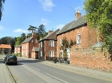
Today it continues to be a linear village
, with much of the 20th century housing built along and just off Park Lane, making the Sutton part now larger than the Bonington part. Sutton Bonington Hall's gardens and parkland are set between the two original settlements and create a gap in the built-up area, and each part continues to have its own pub
and parish church. The most recent significant development are houses built on the former rectory gardens near St Anne's Church, again enlarging the Sutton part. The total length of the village is now 1.25 miles (2 km), not including the university campus.
The Midland Railway
was constructed through the parish in 1840. Sir Cecil Paget
, a notable locomotive engineer and railway administrator, was born in Sutton Bonington and in 1923 succeeded his father (Sir Ernest Paget, who was Chairman of the Midland Railway, 1890—1911) to become the 2nd Baronet Paget of Sutton Bonington
. He died in 1936, without children (the title thereby becoming extinct), and was buried in the family plot at Marlepit Hill cemetery. The Paget family were the main landowners in the parish for much of the 19th century, owning the two ancient manors of St Anne and St Michael. It was under the Pagets that the current St Anne's Manor house and parkland was built, in 1848.
camp during the First World War. In 1948 the college became part of the University of Nottingham.
The campus has steadily grown over the decades (the main part is now approximately 20 hectares) and in 2006 the School of Veterinary Medicine and Science opened. The residential aspect of the campus ("Bonington Halls" — it consists of a number of spread out halls and houses) has also grown substantially in recent years and is now managed by Opal. A masterplan was created in 2008 for the campus and envisages its development over the coming years — growth at present is towards Landcroft Lane, whilst in the future a considerable expansion is planned northwards towards Melton Lane. In 2011 two new buildings will have been completed on the campus: the Veterinary Medicine & Science Building (adjacent to the recently built veterinary sciences building) and the BioEnergy Centre.
, a village hall
& library
, a primary school, a doctor's surgery and two pubs: the Anchor (in the Bonington part) and the King's Head (in the Sutton part). A small industrial estate exists just outside the village on Rempstone Road.
The village also has two medieval
churches, a result of the merging of the two original villages (Sutton and Bonington); they are St Michael's Church
(Bonington's parish church
, located on Main Street) and St Anne's Church
(Sutton's church, located down St Anne's Lane). The village has a large conservation area
at its heart, with 25 Listed buildings contained within it. Sutton Bonington Hall and St Anne's Church are Grade II* (the remainder being Grade II). Sutton Bonington Hall is a country house largely erected in the Queen Anne period and is locally known as "The Hall". In 1825 it came into the ownership of the Paget family and remained a residence until 2000; it has since gone into commercial use as a location for weddings, conferences and parties. There is a Methodist church and a Baptist church in the Sutton part of the village.
Aside from the main village, the parish contains a number of outlying areas of settlement, including the university campus and the hamlet of Zouch. There are also two adjacent clusters of housing towards West Leake, at the junctions of Landcroft Lane/Melton Lane and Melton Lane/Pithouse Lane/Trowell Lane. Within the latter cluster is a 200 year-old public house called the Star known locally as Leake Pit House, since it once incorporated a pit for cock-fighting. Between 1982 and 2004 specialist car manufacturer GTM Cars
used buildings in Trowel Lane as their factory and offices. Since their departure to Coventry these have been used by Talon Sportscars.
In Zouch is the Rose and Crown pub, pub, while the Station Hotel is located adjacent to the former Kegworth railway station
, and lies just outwith the parish near the university campus. Opposite the Hotel on Station Road are two further Listed buildings within the parish (in addition to the 25 in the village) at Sutton Fields — the House and its Lodge. The Kegworth Old Lock, replaced by the Kegworth Deep Lock in the mid-1980s, on the Soar navigation, also lies within Sutton Bonington parish, and became Grade II Listed on 12 October 1987.
The Kingston Brook
runs to the northeast of the parish, forming part of the boundary with West Leake parish. The boundary with Leicestershire is the River Soar and runs along the centre of the river. In places the river has more than one channel, and the boundary then runs at the centre of the widest channel of water, resulting in a number of islands falling within the parish, especially near Kegworth and at Zouch.
Adjacent to the main university campus is the University Farm
, a 400 hectare (4 km²) commercial research farm, and an associated high-technology dairy
centre; the farm partly lies in the neighbouring parish of Kingston on Soar, as does the dairy. Between the university campus and the railway line are offices (formerly a residence called "The Elms") and a laboratory belonging to the Veterinary Laboratories Agency
, and a new sports hall and associated pitches.
.
(closed in 1960) to the southeast. In 2008 East Midlands Parkway
opened at Ratcliffe on Soar, approximately 3.5 miles (5.6 km) to the north, providing good links on the Midland Main Line
, which passes through the parish and on the eastern edge of the village in a cutting
. Junction 24 of the M1 motorway
is only 2.5 miles (4 km) away, near Kegworth, and the East Midlands Airport is also nearby to the west. The A6006 "Rempstone Road" runs along the southeast boundary of the parish — and through Zouch — and leads to the A6. The "Indigo" bus route serves the village and the university campus, with regular buses running between Nottingham
city centre and Loughborough, including stops at Kegworth, the Airport, Long Eaton
and Beeston
. Another, less regular, bus service operates between Nottingham city centre and Normanton on Soar, via Clifton.
The long-distance footpath, the Midshires Way
, passes through the parish, running from West Leake to Kegworth along Melton Lane and Station Road. Two of the country lane
s in the parish (Landcroft Lane and Hungary Lane) were designated as "quiet lanes" in 2004, giving equal priority between vehicular traffic and pedestrians, cyclists and horse riders. The River Soar, which runs through Zouch and then along the western boundary of the parish, is canal
ised and is well used by small watercraft.
electoral district for purposes of electing a councillor to Nottinghamshire County Council. The most recent election was in 2009 when Linda Sykes, of the Conservative party, won the seat. For the election of a councillor to Rushcliffe Borough Council, the parish forms part of the Soar Valley ward
, which covers a smaller area than the electoral district of the same name, and consists of the three parishes of Sutton Bonington, Kingston on Soar and Ratcliffe on Soar. The most recent election was in 2007 when Terry Holt, of the Liberal Democrats, won the seat. The next Borough election will be held in 2011
.
The parish council has 11 councillors; there was an uncontested election for these seats in 2007.
The Member of Parliament
for the Parliamentary
constituency of Rushcliffe
is Kenneth Clarke
, of the Conservative party, who has held the seat since 1970.
wapentake of Nottinghamshire. The two ancient ecclesiastical parishes of Sutton and Bonington were also separate townships
; they were united for civil purposes
in 1829 and combined in 1923 into one ecclesiastical parish. Related to the situation of the two original parishes, Sutton and Bonington are separate manors
, named after their churches — St Anne and St Michael respectively. From 1894 the parish was part of the Leake Rural District
, until its abolition in 1935, when the parish was transferred to the Basford Rural District
. In 1974 Basford Rural District
was abolished and the non-metropolitan district
of Rushcliffe
was created, granted with borough status
immediately, with Sutton Bonington becoming a part of it.
listed) automatic
weather monitoring station situated on the university campus. The station is at 48m ASL just off Landcroft Lane at 52.8282°N 1.2485°W.
Village
A village is a clustered human settlement or community, larger than a hamlet with the population ranging from a few hundred to a few thousand , Though often located in rural areas, the term urban village is also applied to certain urban neighbourhoods, such as the West Village in Manhattan, New...
and civil parish lying along the valley of the River Soar
River Soar
The River Soar is a tributary of the River Trent in the English East Midlands.-Description:It rises near Hinckley in Leicestershire and is joined by the River Sence near Enderby before flowing through Leicester , Barrow-on-Soar, beside Loughborough and Kegworth, before joining the Trent near...
in the Borough of Rushcliffe
Rushcliffe
Rushcliffe is a local government district with borough status in Nottinghamshire, England. Its council is based in West Bridgford. It was formed on 1 April 1974 by merging the West Bridgford Urban District, the Bingham Rural District and part of Basford Rural District.-Political representation:The...
, south west Nottinghamshire
Nottinghamshire
Nottinghamshire is a county in the East Midlands of England, bordering South Yorkshire to the north-west, Lincolnshire to the east, Leicestershire to the south, and Derbyshire to the west...
, England
England
England is a country that is part of the United Kingdom. It shares land borders with Scotland to the north and Wales to the west; the Irish Sea is to the north west, the Celtic Sea to the south west, with the North Sea to the east and the English Channel to the south separating it from continental...
. The University of Nottingham
University of Nottingham
The University of Nottingham is a public research university based in Nottingham, United Kingdom, with further campuses in Ningbo, China and Kuala Lumpur, Malaysia...
has a 420 hectares (4.2 km²) site just to the north of the village: Sutton Bonington Campus.
The parish covers some 2183 acres (8.8 km²) and includes the hamlet of Zouch
Zouch
Zouch is a hamlet in south west Nottinghamshire, England. It is located between Hathern and Normanton on Soar and is situated by the River Soar, which marks the county boundary with Leicestershire....
. The population is about 1,600, not including the students at the university campus who bring the total to over 2,200 in term time. The River Soar is the county
Counties of England
Counties of England are areas used for the purposes of administrative, geographical and political demarcation. For administrative purposes, England outside Greater London and the Isles of Scilly is divided into 83 counties. The counties may consist of a single district or be divided into several...
boundary with Leicestershire
Leicestershire
Leicestershire is a landlocked county in the English Midlands. It takes its name from the heavily populated City of Leicester, traditionally its administrative centre, although the City of Leicester unitary authority is today administered separately from the rest of Leicestershire...
and approximately 2 miles (3.2 km) to the northwest, in Leicestershire, is the large village of Kegworth
Kegworth
Kegworth is a large village and civil parish in Leicestershire, England....
. The nearest town is Loughborough
Loughborough
Loughborough is a town within the Charnwood borough of Leicestershire, England. It is the seat of Charnwood Borough Council and is home to Loughborough University...
, some 5 miles (8 km) by road to the south.
History
Originally, Sutton and Bonington were two settlements, probably originating in Anglo-Saxon times (the names likely derive from South farm and Buna's farm); Sutton was to the south of Bonington. In the Domesday BookDomesday Book
Domesday Book , now held at The National Archives, Kew, Richmond upon Thames in South West London, is the record of the great survey of much of England and parts of Wales completed in 1086...
of 1086 the villages were recorded as "Sudtone" and "Bonitone". The two villages gradually grew together along the edge of the flood plain of the River Soar to make one long, narrow village, which by 1340 had come by the name of "Sutton Bonynton".
Today it continues to be a linear village
Linear village
In geography, a linear village, or linear settlement, is a small to medium-sized settlement that is formed around a transport route, such as a road, river, or canal. Wraysbury, a village in Berkshire, is one of the longest villages in England....
, with much of the 20th century housing built along and just off Park Lane, making the Sutton part now larger than the Bonington part. Sutton Bonington Hall's gardens and parkland are set between the two original settlements and create a gap in the built-up area, and each part continues to have its own pub
Public house
A public house, informally known as a pub, is a drinking establishment fundamental to the culture of Britain, Ireland, Australia and New Zealand. There are approximately 53,500 public houses in the United Kingdom. This number has been declining every year, so that nearly half of the smaller...
and parish church. The most recent significant development are houses built on the former rectory gardens near St Anne's Church, again enlarging the Sutton part. The total length of the village is now 1.25 miles (2 km), not including the university campus.
The Midland Railway
Midland Railway
The Midland Railway was a railway company in the United Kingdom from 1844 to 1922, when it became part of the London, Midland and Scottish Railway....
was constructed through the parish in 1840. Sir Cecil Paget
Cecil Paget
Sir Cecil Walter Paget CMG, DSO , was a British locomotive engineer and railway administrator.Cecil Paget was the son of Sir George Ernest Paget, Chairman of the Midland Railway Company 1890-1911. He was born at Sutton Bonington, educated at Harrow and Pembroke College, Cambridge, and then joined...
, a notable locomotive engineer and railway administrator, was born in Sutton Bonington and in 1923 succeeded his father (Sir Ernest Paget, who was Chairman of the Midland Railway, 1890—1911) to become the 2nd Baronet Paget of Sutton Bonington
Paget Baronets
There have been three Baronetcies created for persons with the surname Paget, all in the Baronetage of the United Kingdom. Two of the creations are extant as of 2010....
. He died in 1936, without children (the title thereby becoming extinct), and was buried in the family plot at Marlepit Hill cemetery. The Paget family were the main landowners in the parish for much of the 19th century, owning the two ancient manors of St Anne and St Michael. It was under the Pagets that the current St Anne's Manor house and parkland was built, in 1848.
University
The university campus was originally the Midland Agricultural and Dairy College, which formed in the first decades of the 20th century. The site was used as a prisoner of warPrisoner of war
A prisoner of war or enemy prisoner of war is a person, whether civilian or combatant, who is held in custody by an enemy power during or immediately after an armed conflict...
camp during the First World War. In 1948 the college became part of the University of Nottingham.
The campus has steadily grown over the decades (the main part is now approximately 20 hectares) and in 2006 the School of Veterinary Medicine and Science opened. The residential aspect of the campus ("Bonington Halls" — it consists of a number of spread out halls and houses) has also grown substantially in recent years and is now managed by Opal. A masterplan was created in 2008 for the campus and envisages its development over the coming years — growth at present is towards Landcroft Lane, whilst in the future a considerable expansion is planned northwards towards Melton Lane. In 2011 two new buildings will have been completed on the campus: the Veterinary Medicine & Science Building (adjacent to the recently built veterinary sciences building) and the BioEnergy Centre.
Features and amenities
The village boasts a number of small shops, a post officePost office
A post office is a facility forming part of a postal system for the posting, receipt, sorting, handling, transmission or delivery of mail.Post offices offer mail-related services such as post office boxes, postage and packaging supplies...
, a village hall
Village hall
In the United States, a village hall is the seat of government for villages. It functions much as a city hall does within cities.In the United Kingdom, a village hall is usually a building within a village which contains at least one large room, usually owned by and run for the benefit of the local...
& library
Public library
A public library is a library that is accessible by the public and is generally funded from public sources and operated by civil servants. There are five fundamental characteristics shared by public libraries...
, a primary school, a doctor's surgery and two pubs: the Anchor (in the Bonington part) and the King's Head (in the Sutton part). A small industrial estate exists just outside the village on Rempstone Road.
The village also has two medieval
Middle Ages
The Middle Ages is a periodization of European history from the 5th century to the 15th century. The Middle Ages follows the fall of the Western Roman Empire in 476 and precedes the Early Modern Era. It is the middle period of a three-period division of Western history: Classic, Medieval and Modern...
churches, a result of the merging of the two original villages (Sutton and Bonington); they are St Michael's Church
St. Michael's Church, Sutton Bonington
St. Michael's Church is a parish church in the Church of England in Sutton Bonington, Nottinghamshire.The church is a 13th century Grade II Listed building.-History:...
(Bonington's parish church
Parish church
A parish church , in Christianity, is the church which acts as the religious centre of a parish, the basic administrative unit of episcopal churches....
, located on Main Street) and St Anne's Church
St. Anne's Church, Sutton Bonington
St. Anne's Church is a parish church in the Church of England in Sutton Bonington, Nottinghamshire.The church is a 12th century Grade II* Listed building....
(Sutton's church, located down St Anne's Lane). The village has a large conservation area
Conservation Area (United Kingdom)
In the United Kingdom, the term Conservation Area nearly always applies to an area considered worthy of preservation or enhancement because of its special architectural or historic interest, "the character or appearance of which it is desirable to preserve or enhance," as required by the Planning ...
at its heart, with 25 Listed buildings contained within it. Sutton Bonington Hall and St Anne's Church are Grade II* (the remainder being Grade II). Sutton Bonington Hall is a country house largely erected in the Queen Anne period and is locally known as "The Hall". In 1825 it came into the ownership of the Paget family and remained a residence until 2000; it has since gone into commercial use as a location for weddings, conferences and parties. There is a Methodist church and a Baptist church in the Sutton part of the village.
Aside from the main village, the parish contains a number of outlying areas of settlement, including the university campus and the hamlet of Zouch. There are also two adjacent clusters of housing towards West Leake, at the junctions of Landcroft Lane/Melton Lane and Melton Lane/Pithouse Lane/Trowell Lane. Within the latter cluster is a 200 year-old public house called the Star known locally as Leake Pit House, since it once incorporated a pit for cock-fighting. Between 1982 and 2004 specialist car manufacturer GTM Cars
GTM Cars
GTM Cars is a component kit car manufacturer located in Kingswinford, UK.The company was founded in 1967 when Bernard Cox and his friend Jack Hosker created the Cox GTM a mid engined Ferrari Dino inspired sports car based on Mini parts. It was an instant hit and they built kits as fast as they...
used buildings in Trowel Lane as their factory and offices. Since their departure to Coventry these have been used by Talon Sportscars.
In Zouch is the Rose and Crown pub, pub, while the Station Hotel is located adjacent to the former Kegworth railway station
Kegworth railway station
Kegworth Railway Station was a station serving the village of Kegworth in Leicestershire, England. It was located nearer to the smaller village of Sutton Bonington however, and situated in Nottinghamshire....
, and lies just outwith the parish near the university campus. Opposite the Hotel on Station Road are two further Listed buildings within the parish (in addition to the 25 in the village) at Sutton Fields — the House and its Lodge. The Kegworth Old Lock, replaced by the Kegworth Deep Lock in the mid-1980s, on the Soar navigation, also lies within Sutton Bonington parish, and became Grade II Listed on 12 October 1987.
The Kingston Brook
Kingston Brook
Kingston Brook is a small river in central England. It arises near Old Dalby, Leicestershire on the northern edge of the ridge running from Normanton-on-Soar, Nottinghamshire to Belvoir, Leicestershire...
runs to the northeast of the parish, forming part of the boundary with West Leake parish. The boundary with Leicestershire is the River Soar and runs along the centre of the river. In places the river has more than one channel, and the boundary then runs at the centre of the widest channel of water, resulting in a number of islands falling within the parish, especially near Kegworth and at Zouch.
Adjacent to the main university campus is the University Farm
University Farm (Nottinghamshire)
University Farm is a 400 hectare commercial research farm attached to the Sutton Bonington Campus of the University of Nottingham, England. It lies across the parishes of Sutton Bonington and Kingston on Soar.-Facilities:...
, a 400 hectare (4 km²) commercial research farm, and an associated high-technology dairy
Dairy
A dairy is a business enterprise established for the harvesting of animal milk—mostly from cows or goats, but also from buffalo, sheep, horses or camels —for human consumption. A dairy is typically located on a dedicated dairy farm or section of a multi-purpose farm that is concerned...
centre; the farm partly lies in the neighbouring parish of Kingston on Soar, as does the dairy. Between the university campus and the railway line are offices (formerly a residence called "The Elms") and a laboratory belonging to the Veterinary Laboratories Agency
Veterinary Laboratories Agency
The Veterinary Laboratories Agency is an executive agency of the UK government's Department for Environment, Food and Rural Affairs . It carries out animal disease surveillance, diagnostic services and veterinary scientific research for government and commercial organisations...
, and a new sports hall and associated pitches.
Sport
Sutton Bonington Cricket Club was founded in 1824. There is a lawn bowls club and a tennis club, both situated at the junction of Marle Pit Hill and Landcroft Lane. Two football teams (Sutton Bonington FC and Sutton Bonington Academicals FC) are based at the sports centre on College Road, and both play in Division One of the North Leicestershire Football LeagueNorth Leicestershire Football League
The North Leicestershire League is a football competition based in Leicestershire, England. This league was established in 1931 and was formerly known as the Loughborough and District Amateur Football Alliance. It has a total of five divisions, the highest of which, the Premier Division, is a...
.
Transport
There were two railway stations close to the village: Kegworth station (closed in 1968) to the north and Hathern stationHathern railway station
Hathern Railway Station was a station serving the village of Hathern in Leicestershire, England.It was built by the Midland Railway on the line originally opened in 1839 by the Midland Counties Railway...
(closed in 1960) to the southeast. In 2008 East Midlands Parkway
East Midlands Parkway railway station
East Midlands Parkway is a railway station located north of Ratcliffe-on-Soar on the Midland Main Line in the East Midlands of England. It provides park and ride facilities for rail passengers on the routes from Leicester to Derby and Nottingham...
opened at Ratcliffe on Soar, approximately 3.5 miles (5.6 km) to the north, providing good links on the Midland Main Line
Midland Main Line
The Midland Main Line is a major railway route in the United Kingdom, part of the British railway system.The present-day line links London St...
, which passes through the parish and on the eastern edge of the village in a cutting
Cut (earthmoving)
In civil engineering, a cut or cutting is where soil or rock material from a hill or mountain is cut out to make way for a canal, road or railway line....
. Junction 24 of the M1 motorway
M1 motorway
The M1 is a north–south motorway in England primarily connecting London to Leeds, where it joins the A1 near Aberford. While the M1 is considered to be the first inter-urban motorway to be completed in the United Kingdom, the first road to be built to motorway standard in the country was the...
is only 2.5 miles (4 km) away, near Kegworth, and the East Midlands Airport is also nearby to the west. The A6006 "Rempstone Road" runs along the southeast boundary of the parish — and through Zouch — and leads to the A6. The "Indigo" bus route serves the village and the university campus, with regular buses running between Nottingham
Nottingham
Nottingham is a city and unitary authority in the East Midlands of England. It is located in the ceremonial county of Nottinghamshire and represents one of eight members of the English Core Cities Group...
city centre and Loughborough, including stops at Kegworth, the Airport, Long Eaton
Long Eaton
Long Eaton is a town in Derbyshire, England. It lies just north of the River Trent about southwest of Nottingham and is part of the Nottingham Urban Area...
and Beeston
Beeston, Nottinghamshire
Beeston is a town in Nottinghamshire, England. It is southwest of Nottingham city centre. Although typically regarded as a suburb of the City of Nottingham, and officially designated as part of the Nottingham Urban Area, for local government purposes it is in the borough of Broxtowe, lying outside...
. Another, less regular, bus service operates between Nottingham city centre and Normanton on Soar, via Clifton.
The long-distance footpath, the Midshires Way
Midshires Way
The Midshires Way is a long distance footpath and bridleway that runs for through Middle England from Bledlow in Buckinghamshire to Stockport, Greater Manchester....
, passes through the parish, running from West Leake to Kegworth along Melton Lane and Station Road. Two of the country lane
Country lane
A country lane is a narrow road in the countryside.In North America and Australia, the term also may refer to rear access roads which act as a secondary vehicular network in cities and towns. Large cities in the US states of Nevada and Texas tend to apply the term to many arterial roads...
s in the parish (Landcroft Lane and Hungary Lane) were designated as "quiet lanes" in 2004, giving equal priority between vehicular traffic and pedestrians, cyclists and horse riders. The River Soar, which runs through Zouch and then along the western boundary of the parish, is canal
Canal
Canals are man-made channels for water. There are two types of canal:#Waterways: navigable transportation canals used for carrying ships and boats shipping goods and conveying people, further subdivided into two kinds:...
ised and is well used by small watercraft.
Local government and elections
The parish comes within the Soar ValleySoar Valley
The Soar Valley in Leicestershire, England is the basin of the River Soar, which rises south of Leicester and flows north through Charnwood before meeting the River Trent at Trent Lock on the Nottinghamshire border....
electoral district for purposes of electing a councillor to Nottinghamshire County Council. The most recent election was in 2009 when Linda Sykes, of the Conservative party, won the seat. For the election of a councillor to Rushcliffe Borough Council, the parish forms part of the Soar Valley ward
Wards of the United Kingdom
A ward in the United Kingdom is an electoral district at sub-national level represented by one or more councillors. It is the primary unit of British administrative and electoral geography .-England:...
, which covers a smaller area than the electoral district of the same name, and consists of the three parishes of Sutton Bonington, Kingston on Soar and Ratcliffe on Soar. The most recent election was in 2007 when Terry Holt, of the Liberal Democrats, won the seat. The next Borough election will be held in 2011
United Kingdom local elections, 2011
The 2011 United Kingdom local elections were held on Thursday 5 May 2011. In England, direct elections were held in all 36 Metropolitan boroughs, 194 Second-tier district authorities, 49 unitary authorities and various mayoral posts, meaning local elections took place in all parts of England with...
.
The parish council has 11 councillors; there was an uncontested election for these seats in 2007.
The Member of Parliament
Member of Parliament
A Member of Parliament is a representative of the voters to a :parliament. In many countries with bicameral parliaments, the term applies specifically to members of the lower house, as upper houses often have a different title, such as senate, and thus also have different titles for its members,...
for the Parliamentary
Parliament of the United Kingdom
The Parliament of the United Kingdom of Great Britain and Northern Ireland is the supreme legislative body in the United Kingdom, British Crown dependencies and British overseas territories, located in London...
constituency of Rushcliffe
Rushcliffe (UK Parliament constituency)
-Elections in the 2000s:-Elections in the 1990s:-Elections in the 80's:-Notes and references:...
is Kenneth Clarke
Kenneth Clarke
Kenneth Harry "Ken" Clarke, QC, MP is a British Conservative politician, currently Member of Parliament for Rushcliffe, Lord Chancellor and Secretary of State for Justice. He was first elected to Parliament in 1970; and appointed a minister in Edward Heath's government, in 1972, and is one of...
, of the Conservative party, who has held the seat since 1970.
Historic
The parish fell within the ancient RushcliffeRushcliffe (wapentake)
Rushcliffe was a wapentake of the historic county of Nottinghamshire, England. It was in the south of the county, on the south side of the River Trent, covering the parishes of Barton in Fabis, Bradmore, Bunny, Clifton with Glapton, Costock, East Leake, Edwalton, Gotham, Keyworth, Kingston on...
wapentake of Nottinghamshire. The two ancient ecclesiastical parishes of Sutton and Bonington were also separate townships
Township (England)
In England, a township is a local division or district of a large parish containing a village or small town usually having its own church...
; they were united for civil purposes
Civil parish
In England, a civil parish is a territorial designation and, where they are found, the lowest tier of local government below districts and counties...
in 1829 and combined in 1923 into one ecclesiastical parish. Related to the situation of the two original parishes, Sutton and Bonington are separate manors
Lord of the Manor
The Lordship of a Manor is recognised today in England and Wales as a form of property and one of three elements of a manor that may exist separately or be combined and may be held in moieties...
, named after their churches — St Anne and St Michael respectively. From 1894 the parish was part of the Leake Rural District
Leake Rural District
Leake was a rural district in Nottinghamshire, England from 1894 to 1935.It was formed from the Nottinghamshire part of the Loughborough rural sanitary district by the Local Government Act 1894 It picked up the parishes of Kingston on Soar and Ratcliffe on Soar in 1927, which had previously been...
, until its abolition in 1935, when the parish was transferred to the Basford Rural District
Basford Rural District
Basford was an rural district close to Nottingham, England, from 1894 to 1974. The district consisted of two detached parts, to the north and south of Nottingham...
. In 1974 Basford Rural District
Rural district
Rural districts were a type of local government area – now superseded – established at the end of the 19th century in England, Wales, and Ireland for the administration of predominantly rural areas at a level lower than that of the administrative counties.-England and Wales:In England...
was abolished and the non-metropolitan district
Non-metropolitan district
Non-metropolitan districts, or colloquially shire districts, are a type of local government district in England. As created, they are sub-divisions of non-metropolitan counties in a so-called "two-tier" arrangement...
of Rushcliffe
Rushcliffe
Rushcliffe is a local government district with borough status in Nottinghamshire, England. Its council is based in West Bridgford. It was formed on 1 April 1974 by merging the West Bridgford Urban District, the Bingham Rural District and part of Basford Rural District.-Political representation:The...
was created, granted with borough status
Borough status in the United Kingdom
Borough status in the United Kingdom is granted by royal charter to local government districts in England, Wales and Northern Ireland. The status is purely honorary, and does not give any additional powers to the council or inhabitants of the district...
immediately, with Sutton Bonington becoming a part of it.
Weather station
Since 1908 Sutton Bonington has had an official (Met OfficeMet Office
The Met Office , is the United Kingdom's national weather service, and a trading fund of the Department for Business, Innovation and Skills...
listed) automatic
Automatic weather station
An automatic weather station is an automated version of the traditional weather station, either to save human labour or to enable measurements from remote areas...
weather monitoring station situated on the university campus. The station is at 48m ASL just off Landcroft Lane at 52.8282°N 1.2485°W.
Climate
As with most of England, Sutton Bonington is in hardiness zone 8 and AHS Heat zone 2.Geographic locale
External links
- Parish of Sutton Bonington
- Sutton Bonington Local History Society Remembering Sutton Bonington
- Sutton Bonington Conservation Area Appraisal (Rushcliffe Borough Council) - many details about the village, including local history, historic maps, and many photographs
- Panorama taken from St Michael's Church tower, showing almost all the old Bonington village
- Photographs of Sutton Bonington in the snow
- Map of Sutton Bonington Campus
Weather station links
- MeteoGroup: Sutton Bonington (hourly weather reports)
- Met Office: Sutton Bonington (month-by-month weather data since 1959)