

Timeline of the 1982 Atlantic hurricane season
Encyclopedia
1982 Atlantic hurricane season
The 1982 Atlantic hurricane season officially began on June 1, 1982 and lasted until November 30, 1982, and was a below average season. These dates conventionally delimit the period of each year when most tropical cyclones form in the Atlantic basin...
was an inactive Atlantic hurricane season
Atlantic hurricane season
The Atlantic hurricane season is the period in a year when hurricanes usually form in the Atlantic Ocean. Tropical cyclones in the North Atlantic are called hurricanes, tropical storms, or tropical depressions. In addition, there have been several storms over the years that have not been fully...
, during which five tropical cyclone
Tropical cyclone
A tropical cyclone is a storm system characterized by a large low-pressure center and numerous thunderstorms that produce strong winds and heavy rain. Tropical cyclones strengthen when water evaporated from the ocean is released as the saturated air rises, resulting in condensation of water vapor...
s formed. The season officially began on June 1, 1982 and ended on November 30, dates which conventionally limit the period of each year when tropical cyclones tend to form in the Atlantic. However, most of the activity was constrained to the month of September. This timeline documents tropical cyclone
Tropical cyclone
A tropical cyclone is a storm system characterized by a large low-pressure center and numerous thunderstorms that produce strong winds and heavy rain. Tropical cyclones strengthen when water evaporated from the ocean is released as the saturated air rises, resulting in condensation of water vapor...
formations, strengthening, weakening, landfalls
Landfall (meteorology)
Landfall is the event of a tropical cyclone or a waterspout coming onto land after being over water. When a waterspout makes landfall it is reclassified as a tornado, which can then cause damage inland...
, extratropical transitions, as well as dissipations during the season. The timeline also includes information which was not operationally released, meaning that information from post-storm reviews by the National Hurricane Center
National Hurricane Center
The National Hurricane Center , located at Florida International University in Miami, Florida, is the division of the National Weather Service responsible for tracking and predicting weather systems within the tropics between the Prime Meridian and the 140th meridian west poleward to the 30th...
, such as information on a storm that was not operationally warned upon.
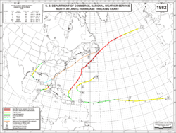
This season produced eight tropical depressions, of which five became named storms; two attained hurricane status, of which one became a major hurricane
Tropical cyclone scales
Tropical systems are officially ranked on one of several tropical cyclone scales according to their maximum sustained winds and in what oceanic basin they are located...
, a storm that ranks as a Category 3 or higher on the Saffir-Simpson Hurricane Scale
Saffir-Simpson Hurricane Scale
The Saffir–Simpson Hurricane Scale , or the Saffir–Simpson Hurricane Wind Scale , classifies hurricanes — Western Hemisphere tropical cyclones that exceed the intensities of tropical depressions and tropical storms — into five categories distinguished by the intensities of their sustained winds...
. Hurricane Alberto was one of four storms to attain hurricane status in the Gulf of Mexico
Gulf of Mexico
The Gulf of Mexico is a partially landlocked ocean basin largely surrounded by the North American continent and the island of Cuba. It is bounded on the northeast, north and northwest by the Gulf Coast of the United States, on the southwest and south by Mexico, and on the southeast by Cuba. In...
and not make landfall. The other three were Laurie of 1969, Henri of 1979, and Jeanne of 1980
Hurricane Jeanne (1980)
Hurricane Jeanne was a moderate hurricane that formed and dissipated in the Gulf of Mexico without making landfall. The tenth tropical cyclone and eighth hurricane of the 1980 Atlantic hurricane season, Jeanne developed over the southern Caribbean on November 7. It moved swiftly northward, and it...
. However, rains from Alberto caused severe flooding, which killed 23 people in Cuba
Cuba
The Republic of Cuba is an island nation in the Caribbean. The nation of Cuba consists of the main island of Cuba, the Isla de la Juventud, and several archipelagos. Havana is the largest city in Cuba and the country's capital. Santiago de Cuba is the second largest city...
. Hurricane Debby was the only major hurricane of the season, peaking as a weak Category 4 over the open waters of the Atlantic basin. Tropical Storm Ernesto was the last storm of the season. It peaked in intensity on October 2 just below hurricane status. The storm dissipated the next day, 58 days before the official end of the season.
Timeline of storms
Image:1982 ATL Timeline.png|
rect 148 19 189 31 Hurricane Alberto
Hurricane Alberto (1982)
Hurricane Alberto caused the worst flooding in western Cuba in 32 years. The first tropical storm and hurricane of the 1982 Atlantic hurricane season, Alberto developed from a tropical disturbance on June 2 in the southern Gulf of Mexico...
rect 197 36 224 48 Subtropical Storm One
Subtropical Storm One (1982)
The 1982 Florida subtropical storm, officially known as Subtropical Storm One, was the only subtropical cyclone of the inactive 1982 Atlantic hurricane season. The storm originated from two different systems around the Gulf of Mexico and Caribbean Sea on June 16. The systems merged into trough...
rect 474 19 504 30 Tropical Storm Beryl
rect 486 36 522 49 Tropical Depression Three
rect 495 54 526 66 Tropical Storm Chris
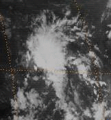
Tropical Storm Chris (1982)
Tropical Storm Chris was the weakest storm of the 1982 Atlantic hurricane season. Affecting the Gulf Coast, Chris resulted in $2 million ) to the United States locations of Texas and Louisiana. The storm formed on September 9 from an upper-low pressure system that formed a few days previously...
rect 524 73 563 86 Hurricane Debby
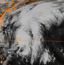
Hurricane Debby (1982)
Hurricane Debby was the strongest tropical cyclone of the 1982 Atlantic hurricane season, peaking with winds of 135 mph . The fourth named storm of the season, it lasted roughly one week over the Atlantic Ocean, affecting Puerto Rico, Bermuda, Nova Scotia, and Newfoundland. Light damage was...
rect 525 92 544 103 Tropical Depression Six
rect 547 18 585 30 Tropical Depression Seven
rect 565 36 612 48 Tropical Storm Ernesto
rect 0 0 799 200 Image:1982 ATL Timeline.png
desc none
June
June 1.jpg)
- The Atlantic hurricane season officially begins.
June 2
- 2 p.m. EDT (1800 UTCCoordinated Universal TimeCoordinated Universal Time is the primary time standard by which the world regulates clocks and time. It is one of several closely related successors to Greenwich Mean Time. Computer servers, online services and other entities that rely on having a universally accepted time use UTC for that purpose...
) – Tropical Depression One forms 75 miles (120 km)The figures for maximum sustained windMaximum sustained windThe maximum sustained winds associated with a tropical cyclone are a common indicator of the intensity of the storm. Within a mature tropical cyclone, they are found within the eyewall at a distance defined as the radius of maximum wind, or RMW. Unlike gusts, the value of these winds are...
s and position estimates are rounded to the nearest 5 units (knots, miles, or kilometers), following the convention used in the National Hurricane CenterNational Hurricane CenterThe National Hurricane Center , located at Florida International University in Miami, Florida, is the division of the National Weather Service responsible for tracking and predicting weather systems within the tropics between the Prime Meridian and the 140th meridian west poleward to the 30th...
's operational products for each storm. All other units are rounded to the nearest digit. north-northeast of CancúnCancúnCancún is a city of international tourism development certified by the UNWTO . Located on the northeast coast of Quintana Roo in southern Mexico, more than 1,700 km from Mexico City, the Project began operations in 1974 as Integrally Planned Center, a pioneer of FONATUR Cancún is a city of...
, MexicoMexicoThe United Mexican States , commonly known as Mexico , is a federal constitutional republic in North America. It is bordered on the north by the United States; on the south and west by the Pacific Ocean; on the southeast by Guatemala, Belize, and the Caribbean Sea; and on the east by the Gulf of...
.
June 3
- 2 a.m. EDT (0600 UTC) – Tropical Depression One strengthens into Tropical Storm AlbertoHurricane Alberto (1982)Hurricane Alberto caused the worst flooding in western Cuba in 32 years. The first tropical storm and hurricane of the 1982 Atlantic hurricane season, Alberto developed from a tropical disturbance on June 2 in the southern Gulf of Mexico...
. - 2 p.m. EDT (1800 UTC) - Tropical Storm Alberto strengthens into a hurricane.
June 4
- 2 a.m. EDT (0600 UTC) - Hurricane Alberto weakens into a tropical storm.
- 8 p.m. EDT (0000 UTC June 5) - Tropical Storm Alberto weakens into a tropical depression.
June 6
- 8 a.m. EDT (1200 UTC) - Tropical Depression Alberto degenerates into a tropical disturbance shortly before dissipating.
June 17
- 8 p.m. EDT (0000 UTC June 18) - Subtropical Depression OneSubtropical Storm One (1982)The 1982 Florida subtropical storm, officially known as Subtropical Storm One, was the only subtropical cyclone of the inactive 1982 Atlantic hurricane season. The storm originated from two different systems around the Gulf of Mexico and Caribbean Sea on June 16. The systems merged into trough...
forms 280 miles (450 km) west-southwest of Cape Coral, FloridaCape Coral, FloridaCape Coral is a municipality located in Lee County, Florida, United States, on the Gulf of Mexico. Founded in 1957 and developed as a master-planned, pre-platted community, the city grew to a population of 154,305 by the year 2010. With an area of , Cape Coral is the largest city between Tampa and...
.
June 18
- 8 a.m. EDT (1200 UTC) - Subtropical Depression One strengthens into a Subtropical Storm and makes landfall near Spring Hill, FloridaSpring Hill, FloridaSpring Hill is a census-designated place in Hernando County, Florida, United States. The estimated population was 92,144 in 2007 by the United States Census. Spring Hill belongs to Florida's Nature Coast and is in the Tampa-St...
with winds of 45 mph (75 km/h).
June 19
- 8 a.m. EDT (1200 UTC) - Subtropical Storm One makes landfall on the Outer BanksOuter BanksThe Outer Banks is a 200-mile long string of narrow barrier islands off the coast of North Carolina, beginning in the southeastern corner of Virginia Beach on the east coast of the United States....
of North CarolinaNorth CarolinaNorth Carolina is a state located in the southeastern United States. The state borders South Carolina and Georgia to the south, Tennessee to the west and Virginia to the north. North Carolina contains 100 counties. Its capital is Raleigh, and its largest city is Charlotte...
with winds of 70 mph (110 km/h).
June 20
- 2 p.m. EDT (1800 UTC) - Subtropical Storm One transitions into an extratropical cycloneExtratropical cycloneExtratropical cyclones, sometimes called mid-latitude cyclones or wave cyclones, are a group of cyclones defined as synoptic scale low pressure weather systems that occur in the middle latitudes of the Earth having neither tropical nor polar characteristics, and are connected with fronts and...
just south of Newfoundland.
August
August 28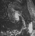
- 8 a.m. ASTUTC-4UTC−04-00 is an identifier for a time offset from UTC of −04.This offset is used in the Atlantic Standard Time Zone in Canada and the North American Eastern Time Zone during daylight saving time , in the Caribbean region this is considered as the Eastern Caribbean timezone...
(1200 UTC) - Tropical Depression Two forms 120 miles (195 km) southeast of Praia, Cape Verde. - 2 p.m. AST (1800 UTC) - Tropical Depression Two strengthens into Tropical Storm Beryl.
August 29
- 2 a.m. AST (0600 UTC) - Tropical Storm Beryl makes its closest approach to the Cape VerdeCape VerdeThe Republic of Cape Verde is an island country, spanning an archipelago of 10 islands located in the central Atlantic Ocean, 570 kilometres off the coast of Western Africa...
Islands, passing 40 miles (65 km) south of the island of BravaBrava, Cape VerdeBrava is an island in Cape Verde. It is the smallest inhabited island, but at the same time the greenest, of Cape Verde, in the Sotavento group. First settled in the 1540s, its population grew after Mount Fogo on neighbouring Fogo erupted in 1675...
with winds of 45 mph (75 km/h).
September
September 2- 2 p.m. AST (1800 UTC) - Tropical Storm Beryl weakens to a tropical depression.
September 5
- 8 p.m. AST (0000 UTC September 6) - Tropical Depression Three forms 560 miles (900 km) east of GuadeloupeGuadeloupeGuadeloupe is an archipelago located in the Leeward Islands, in the Lesser Antilles, with a land area of 1,628 square kilometres and a population of 400,000. It is the first overseas region of France, consisting of a single overseas department. As with the other overseas departments, Guadeloupe...
.
September 6
- 2 p.m. AST (1800 UTC) - Tropical Depression Beryl dissipates over open waters.
September 8
.jpg)
- 7 p.m. CDT (0000 UTC September 9) - Subtropical Depression Two forms 265 miles (425 km) south-southeast of New Orleans, LouisianaLouisianaLouisiana is a state located in the southern region of the United States of America. Its capital is Baton Rouge and largest city is New Orleans. Louisiana is the only state in the U.S. with political subdivisions termed parishes, which are local governments equivalent to counties...
.
September 9
- 8 a.m. AST (1200 UTC) - Tropical Depression Three dissipates over open waters.
- 7 p.m. CDT (0000 UTC September 10) - Subtropical Depression Two transitions into a tropical cyclone, but is not given a number.
September 10
- 7 a.m. CDT (1200 UTC) - The Unnumbered Tropical Depression strengthens into Tropical Storm ChrisTropical Storm Chris (1982)Tropical Storm Chris was the weakest storm of the 1982 Atlantic hurricane season. Affecting the Gulf Coast, Chris resulted in $2 million ) to the United States locations of Texas and Louisiana. The storm formed on September 9 from an upper-low pressure system that formed a few days previously...
.
September 11
- 7 a.m. CDT (1200 UTC) - Tropical Storm Chris makes landfall near Sabine PassSabine PassSabine Pass is the natural outlet of Sabine Lake into the Gulf of Mexico. It borders Jefferson County, Texas, and Cameron Parish, Louisiana.Two major battles occurred here during the American Civil War, known as the First and Second Battles of Sabine Pass....
, TexasTexasTexas is the second largest U.S. state by both area and population, and the largest state by area in the contiguous United States.The name, based on the Caddo word "Tejas" meaning "friends" or "allies", was applied by the Spanish to the Caddo themselves and to the region of their settlement in...
with winds of 65 mph (100 km/h). - 7 p.m. CDT (0000 UTC September 12) - Tropical Storm Chris weakens to a tropical depression.
September 12
- 7 p.m. CDT (0000 UTC September 13) - Tropical Depression Chris dissipates over ArkansasArkansasArkansas is a state located in the southern region of the United States. Its name is an Algonquian name of the Quapaw Indians. Arkansas shares borders with six states , and its eastern border is largely defined by the Mississippi River...
.
September 13
- 8 a.m. AST (1200 UTC) - Tropical Depression Five forms 95 miles (150 km) north-northeast of Santo DomingoSanto DomingoSanto Domingo, known officially as Santo Domingo de Guzmán, is the capital and largest city in the Dominican Republic. Its metropolitan population was 2,084,852 in 2003, and estimated at 3,294,385 in 2010. The city is located on the Caribbean Sea, at the mouth of the Ozama River...
, Dominican RepublicDominican RepublicThe Dominican Republic is a nation on the island of La Hispaniola, part of the Greater Antilles archipelago in the Caribbean region. The western third of the island is occupied by the nation of Haiti, making Hispaniola one of two Caribbean islands that are shared by two countries...
.
September 14
- 8 a.m. AST (1200 UTC) - Tropical Depression Five strengthens into Tropical Storm DebbyHurricane Debby (1982)Hurricane Debby was the strongest tropical cyclone of the 1982 Atlantic hurricane season, peaking with winds of 135 mph . The fourth named storm of the season, it lasted roughly one week over the Atlantic Ocean, affecting Puerto Rico, Bermuda, Nova Scotia, and Newfoundland. Light damage was...
. - 8 p.m. AST (0000 UTC September 15) - Tropical Storm Debby strengthens into a hurricane.
September 15
- 2 p.m. AST (1800 UTC) - Hurricane Debby strengthens into a Category 2 hurricane.
September 16
- exact time unknown - Tropical Depression Six forms 900 miles (1,400 km) west of the Cape Verde Islands.
September 17
- 2 p.m. AST (1800 UTC) - Hurricane Debby strengthens into a major hurricane—a storm with winds of 111 mph (178 km/h) or higher.
- 8 p.m. AST (0000 UTC September 18) - Hurricane Debby strengthens into a Category 4 hurricane.
September 18
- 2 a.m. AST (0600 UTC) - Hurricane Debby weakens to a Category 3 hurricane.
- 8 p.m. AST (0000 UTC September 19) - Hurricane Debby weakens to a Category 2 hurricane and makes its closest approach to Newfoundland, passing within 95 miles (150 km) of the southeastern shore with winds of 105 mph (165 km/h).
September 19
- 2 a.m. AST (0600 UTC) - Hurricane Debby weakens to a Category 1 hurricane.
September 20
- 2 a.m. AST (0600 UTC) - Hurricane Debby weakens to a tropical storm.
- 2 p.m. AST (1800 UTC) - Tropical Storm Debby transitions into an extratropical cyclone over open waters.
- exact time unknown - Tropical Depression Six dissipates 750 miles (1,210 km) east of the Leeward IslandsLeeward IslandsThe Leeward Islands are a group of islands in the West Indies. They are the northern islands of the Lesser Antilles chain. As a group they start east of Puerto Rico and reach southward to Dominica. They are situated where the northeastern Caribbean Sea meets the western Atlantic Ocean...
.
September 23
- 8 p.m. AST (0000 UTC September 24) - Tropical Depression Seven forms 365 miles (590 km) west of Nassau, BahamasNassau, BahamasNassau is the capital, largest city, and commercial centre of the Commonwealth of the Bahamas. The city has a population of 248,948 , 70 percent of the entire population of The Bahamas...
.
September 27
- 8 a.m. AST (1200 UTC) - Tropical Depression Seven dissipates over open waters.
September 30
- 8 a.m. AST (1200 UTC) - Tropical Depression Eight forms 445 miles (720 km) northeast of the Turks and Caicos IslandsTurks and Caicos IslandsThe Turks and Caicos Islands are a British Overseas Territory and overseas territory of the European Union consisting of two groups of tropical islands in the Caribbean, the larger Caicos Islands and the smaller Turks Islands, known for tourism and as an offshore financial centre.The Turks and...
.
October
October 1- 2 a.m. AST (0600 UTC) - Tropical Depression Eight strengthens into Tropical Storm Ernesto.
October 2
- 8 p.m. AST (0000 UTC October 3) - Tropical Storm Ernesto transitions into an extratropical cyclone.