
South Jasper Range
Encyclopedia
The South Jasper Ranges are mountain range
s of the Rocky Mountains
in Alberta
and British Columbia
, Canada
.
It is a part of the Central Main Ranges of the Canadian Rockies
, located on the continental divide
, in Jasper National Park
and Mount Robson Provincial Park
. It contains the Meadow-Clairvaux, Fraser-Rampart, Trident Range and, most prominently, the Cavell Group of mountain
s and the headwaters of the Athabasca
and Fraser River
.
The South Jasper Ranges covers a surface of 1,196 km² (462 mi²), has a length of 39 km (from north to south) and a width of 49 km.
Mountain range
A mountain range is a single, large mass consisting of a succession of mountains or narrowly spaced mountain ridges, with or without peaks, closely related in position, direction, formation, and age; a component part of a mountain system or of a mountain chain...
s of the Rocky Mountains
Rocky Mountains
The Rocky Mountains are a major mountain range in western North America. The Rocky Mountains stretch more than from the northernmost part of British Columbia, in western Canada, to New Mexico, in the southwestern United States...
in Alberta
Alberta
Alberta is a province of Canada. It had an estimated population of 3.7 million in 2010 making it the most populous of Canada's three prairie provinces...
and British Columbia
British Columbia
British Columbia is the westernmost of Canada's provinces and is known for its natural beauty, as reflected in its Latin motto, Splendor sine occasu . Its name was chosen by Queen Victoria in 1858...
, Canada
Canada
Canada is a North American country consisting of ten provinces and three territories. Located in the northern part of the continent, it extends from the Atlantic Ocean in the east to the Pacific Ocean in the west, and northward into the Arctic Ocean...
.
It is a part of the Central Main Ranges of the Canadian Rockies
Canadian Rockies
The Canadian Rockies comprise the Canadian segment of the North American Rocky Mountains range. They are the eastern part of the Canadian Cordillera, extending from the Interior Plains of Alberta to the Rocky Mountain Trench of British Columbia. The southern end borders Idaho and Montana of the USA...
, located on the continental divide
Continental divide
A continental divide is a drainage divide on a continent such that the drainage basin on one side of the divide feeds into one ocean or sea, and the basin on the other side either feeds into a different ocean or sea, or else is endorheic, not connected to the open sea...
, in Jasper National Park
Jasper National Park
Jasper National Park is the largest national park in the Canadian Rockies, spanning 10,878 km² . It is located in the province of Alberta, north of Banff National Park and west of the City of Edmonton. The park includes the glaciers of the Columbia Icefield, hot springs, lakes, waterfalls and...
and Mount Robson Provincial Park
Mount Robson Provincial Park
Mount Robson Provincial Park is a large provincial park in the Canadian Rockies with an area of 2,249 km². The park is located entirely within British Columbia, bordering Jasper National Park in Alberta. The B.C. legislature created the park in 1913, the same year as the first ascent of Mount...
. It contains the Meadow-Clairvaux, Fraser-Rampart, Trident Range and, most prominently, the Cavell Group of mountain
Mountain
Image:Himalaya_annotated.jpg|thumb|right|The Himalayan mountain range with Mount Everestrect 58 14 160 49 Chomo Lonzorect 200 28 335 52 Makalurect 378 24 566 45 Mount Everestrect 188 581 920 656 Tibetan Plateaurect 250 406 340 427 Rong River...
s and the headwaters of the Athabasca
Athabasca River
The Athabasca River originates from the Columbia Glacier of the Columbia Icefield in Jasper National Park in Alberta, Canada...
and Fraser River
Fraser River
The Fraser River is the longest river within British Columbia, Canada, rising at Fraser Pass near Mount Robson in the Rocky Mountains and flowing for , into the Strait of Georgia at the city of Vancouver. It is the tenth longest river in Canada...
.
The South Jasper Ranges covers a surface of 1,196 km² (462 mi²), has a length of 39 km (from north to south) and a width of 49 km.
Peaks and mountains
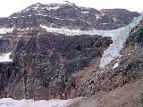
- Mount Edith CavellMount Edith CavellMount Edith Cavell is a mountain located in the Athabasca River and Astoria River valleys of Jasper National Park, Canada. The mountain was named in 1916 for Edith Cavell, an English nurse and spy executed by the Germans during World War I for having helped allied soldiers escape from occupied...
- 3363 m (11,033 ft) - Simon PeakSimon PeakSimon Peak is a mountain rising to about 1,000 m on the west side of Havre Mountains, northwest Alexander Island, northeast of Umber Island. Possibly sighted by FAE, 1908-10, in January 1909; surveyed by British Antarctic Survey , 1975-76. Named after Alec Edward Simon, BAS aircraft mechanic,...
- 3313 m (10,869 ft) - Throne Mountain - 3120 m (10,236 ft)
- Blackhorn Peak - 3000 m (9,843 ft)
- Chevron Mountain - 2879 m (9,446 ft)
- Tonquin HillTonquin HillTonquin Hill is located on the border of Alberta and British Columbia. It was named in 1916 by E. Deville.-See also:* List of peaks on the British Columbia-Alberta border* Mountains of Alberta* Mountains of British Columbia...
- 2398 m (7,867 ft)