Mount Robson Provincial Park
Encyclopedia
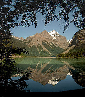
Mount Robson Provincial Park is a large provincial park in the Canadian Rockies
with an area of 2,249 km². The park is located entirely within British Columbia
, bordering Jasper National Park
in Alberta
. The B.C. legislature created the park in 1913, the same year as the first ascent of Mount Robson
by a party led by Conrad Kain
. The park is named for Mount Robson
, which has the highest point in the Canadian Rockies and is located entirely within the park.
 The first recreational trail was built in 1913 by Jasper outfitter Donald "Curly" Phillips along the Robson River
to Berg Lake
.
From May to September, a visitor centre is open just south of the Mt. Robson Viewpoint on the Yellowhead Highway
. The only services within the park are at a combination coffee-shop gas station complex at the Viewpoint.
To reach the park, follow the Yellowhead Highway
390 kilometres west of Edmonton or 290 kilometres east of Prince George
.
World Heritage Site
in 1984, together with the other national and provincial park
s that form the Canadian Rocky Mountain Parks
, for the mountain landscapes containing mountain peaks, glacier
s, lakes, waterfalls, canyon
s and limestone caves as well as fossil
s found here.
Canadian Rockies
The Canadian Rockies comprise the Canadian segment of the North American Rocky Mountains range. They are the eastern part of the Canadian Cordillera, extending from the Interior Plains of Alberta to the Rocky Mountain Trench of British Columbia. The southern end borders Idaho and Montana of the USA...
with an area of 2,249 km². The park is located entirely within British Columbia
British Columbia
British Columbia is the westernmost of Canada's provinces and is known for its natural beauty, as reflected in its Latin motto, Splendor sine occasu . Its name was chosen by Queen Victoria in 1858...
, bordering Jasper National Park
Jasper National Park
Jasper National Park is the largest national park in the Canadian Rockies, spanning 10,878 km² . It is located in the province of Alberta, north of Banff National Park and west of the City of Edmonton. The park includes the glaciers of the Columbia Icefield, hot springs, lakes, waterfalls and...
in Alberta
Alberta
Alberta is a province of Canada. It had an estimated population of 3.7 million in 2010 making it the most populous of Canada's three prairie provinces...
. The B.C. legislature created the park in 1913, the same year as the first ascent of Mount Robson
Mount Robson
Mount Robson is the most prominent mountain in North America's Rocky Mountain range; it is also the highest point in the Canadian Rockies. The mountain is located entirely within Mount Robson Provincial Park of British Columbia, and is part of the Rainbow Range. It is commonly thought to be the...
by a party led by Conrad Kain
Conrad Kain
Conrad Kain was an Austrian mountain guide who guided extensively in Europe, Canada, and New Zealand, and was responsible for the first ascents of more than 60 routes in British Columbia...
. The park is named for Mount Robson
Mount Robson
Mount Robson is the most prominent mountain in North America's Rocky Mountain range; it is also the highest point in the Canadian Rockies. The mountain is located entirely within Mount Robson Provincial Park of British Columbia, and is part of the Rainbow Range. It is commonly thought to be the...
, which has the highest point in the Canadian Rockies and is located entirely within the park.

Robson River
The Robson River is a short but swift, rapid and waterfall-infested river in Mount Robson Provincial Park of British Columbia. It is a tributary of the Upper Fraser River and it originates near Robson Pass, which divides the Robson River & the headwaters of the Smoky River drainage...
to Berg Lake
Berg Lake
Berg Lake is a lake on the Robson River just below the river's source located within Mount Robson Provincial Park, at the doorstep of the north face of Mount Robson, the highest peak in the Canadian Rockies. It is partly fed by the Berg Glacier....
.
From May to September, a visitor centre is open just south of the Mt. Robson Viewpoint on the Yellowhead Highway
Yellowhead Highway
The Yellowhead Highway is a major east-west highway connecting the four western Canadian provinces of British Columbia, Alberta, Saskatchewan, and Manitoba. Although part of the Trans-Canada Highway system, the highway should not be confused with the more southerly, originally-designated...
. The only services within the park are at a combination coffee-shop gas station complex at the Viewpoint.
To reach the park, follow the Yellowhead Highway
Yellowhead Highway
The Yellowhead Highway is a major east-west highway connecting the four western Canadian provinces of British Columbia, Alberta, Saskatchewan, and Manitoba. Although part of the Trans-Canada Highway system, the highway should not be confused with the more southerly, originally-designated...
390 kilometres west of Edmonton or 290 kilometres east of Prince George
Prince George, British Columbia
Prince George, with a population of 71,030 , is the largest city in northern British Columbia, Canada, and is known as "BC's Northern Capital"...
.
World Heritage Site
Mount Robson Park was declared a UNESCOUNESCO
The United Nations Educational, Scientific and Cultural Organization is a specialized agency of the United Nations...
World Heritage Site
World Heritage Site
A UNESCO World Heritage Site is a place that is listed by the UNESCO as of special cultural or physical significance...
in 1984, together with the other national and provincial park
Provincial park
A provincial park is a park under the management of a provincial or territorial government in Canada.While provincial parks are not the same as national parks, their workings are very similar...
s that form the Canadian Rocky Mountain Parks
Canadian Rocky Mountain Parks
The Canadian Rocky Mountain Parks World Heritage Site is located in the Canadian Rockies. It consists of four national parks:*Banff*Jasper*Kootenay*Yohoand three British Columbia provincial parks:*Hamber Provincial Park...
, for the mountain landscapes containing mountain peaks, glacier
Glacier
A glacier is a large persistent body of ice that forms where the accumulation of snow exceeds its ablation over many years, often centuries. At least 0.1 km² in area and 50 m thick, but often much larger, a glacier slowly deforms and flows due to stresses induced by its weight...
s, lakes, waterfalls, canyon
Canyon
A canyon or gorge is a deep ravine between cliffs often carved from the landscape by a river. Rivers have a natural tendency to reach a baseline elevation, which is the same elevation as the body of water it will eventually drain into. This forms a canyon. Most canyons were formed by a process of...
s and limestone caves as well as fossil
Fossil
Fossils are the preserved remains or traces of animals , plants, and other organisms from the remote past...
s found here.
See also
- List of British Columbia Provincial Parks
- List of Canadian provincial parks
- List of National Parks of Canada
- List of World Heritage Sites in the Americas
External links
- BC Parks - Mount Robson Provincial Park website
- UN database entry

