

Sidoarjo mud flow
Encyclopedia
Indonesian language
Indonesian is the official language of Indonesia. Indonesian is a normative form of the Riau Islands dialect of Malay, an Austronesian language which has been used as a lingua franca in the Indonesian archipelago for centuries....
word for mud), is a mud volcano
Mud volcano
The term mud volcano or mud dome are used to refer to formations created by geo-excreted liquids and gases, although there are several different processes which may cause such activity. Hot water mixes with mud and surface deposits. Mud volcanoes are associated with subduction zones and about 700...
in the subdistrict of Porong, Sidoarjo
Sidoarjo
Sidoarjo is a regency of East Java, Indonesia.Sidoarjo is bordered by Surabaya city and Gresik regency to the north, by Pasuruan regency to the south, by Mojokerto regency to the west and by the Madura Strait to the east. It has an area of 634.89 km², making it the smallest regency in East Java. ...
in East Java
East Java
East Java is a province of Indonesia. It is located on the eastern part of the island of Java and includes neighboring Madura and islands to its east and to its north East Java is a province of Indonesia. It is located on the eastern part of the island of Java and includes neighboring Madura and...
, Indonesia
Indonesia
Indonesia , officially the Republic of Indonesia , is a country in Southeast Asia and Oceania. Indonesia is an archipelago comprising approximately 13,000 islands. It has 33 provinces with over 238 million people, and is the world's fourth most populous country. Indonesia is a republic, with an...
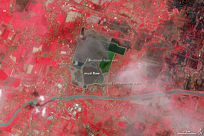
that has been in eruption since May 2006. This biggest mud volcano in the world was created by the blowout
Blowout (well drilling)
A blowout is the uncontrolled release of crude oil and/or natural gas from an oil well or gas well after pressure control systems have failed....
of a natural gas well drilled by PT Lapindo Brantas
PT Lapindo Brantas
PT Lapindo Brantas is an Indonesian oil and gas exploration company.It is a subsidiary owned by PT Energi Mega Persada Tbk and 60% owned and controlled by the Bakrie Group. The Bakrie Group is owned by the former Coordinating Minister for the People's Welfare Aburizal Bakrie and his brothers...
, although company officials contend that it was caused by a distant earthquake.
At its peak Lusi was spewing up to 180,000 m³ of mud per day. In mid August 2011, mud was being discharged at a rate of 10,000 cubic metres per day, with 15 bubbles around the gush point. This was a significant decline from a year previous, when mud was being discharged at a rate of 100,000 cubic metres per day with 320 bubbles around the gush point. It is expected that the flow will continue for the next 25 to 30 years. Although the Sidoarjo mud flow has been contained by levee
Levee
A levee, levée, dike , embankment, floodbank or stopbank is an elongated naturally occurring ridge or artificially constructed fill or wall, which regulates water levels...
s since November 2008, resultant flooding regularly disrupts local highways and villages, and further breakouts of mud are still possible.
Geological setting
Mud volcano systemsMud volcano
The term mud volcano or mud dome are used to refer to formations created by geo-excreted liquids and gases, although there are several different processes which may cause such activity. Hot water mixes with mud and surface deposits. Mud volcanoes are associated with subduction zones and about 700...
are fairly common on Earth, and particularly in East Java
East Java
East Java is a province of Indonesia. It is located on the eastern part of the island of Java and includes neighboring Madura and islands to its east and to its north East Java is a province of Indonesia. It is located on the eastern part of the island of Java and includes neighboring Madura and...
province. Beneath the island of Java is a half-graben lying in the east-west direction, filled with overpressured marine carbonate
Carbonate
In chemistry, a carbonate is a salt of carbonic acid, characterized by the presence of the carbonate ion, . The name may also mean an ester of carbonic acid, an organic compound containing the carbonate group C2....
s and marine muds. It forms an inverted
Inversion (geology)
In structural geology inversion or basin inversion relates to the relative uplift of a sedimentary basin or similar structure as a result of crustal shortening. This normally excludes uplift developed in the footwalls of later extensional faults, or uplift caused by mantle plumes...
extensional basin which has been geologically active since the Paleogene
Paleogene
The Paleogene is a geologic period and system that began 65.5 ± 0.3 and ended 23.03 ± 0.05 million years ago and comprises the first part of the Cenozoic Era...
epoch. The basin started to become overpressured during the Oligo
Oligocene
The Oligocene is a geologic epoch of the Paleogene Period and extends from about 34 million to 23 million years before the present . As with other older geologic periods, the rock beds that define the period are well identified but the exact dates of the start and end of the period are slightly...
-Miocene
Miocene
The Miocene is a geological epoch of the Neogene Period and extends from about . The Miocene was named by Sir Charles Lyell. Its name comes from the Greek words and and means "less recent" because it has 18% fewer modern sea invertebrates than the Pliocene. The Miocene follows the Oligocene...
period. Some of the overpressured mud escapes to the surface to form mud volcanoes, which have been observed at Sangiran Dome and near Purwodadi city, 200 km (124.3 mi) west of Lusi.
The East Java Basin contains a significant amount of oil
Petroleum
Petroleum or crude oil is a naturally occurring, flammable liquid consisting of a complex mixture of hydrocarbons of various molecular weights and other liquid organic compounds, that are found in geologic formations beneath the Earth's surface. Petroleum is recovered mostly through oil drilling...
and gas
Natural gas
Natural gas is a naturally occurring gas mixture consisting primarily of methane, typically with 0–20% higher hydrocarbons . It is found associated with other hydrocarbon fuel, in coal beds, as methane clathrates, and is an important fuel source and a major feedstock for fertilizers.Most natural...
reserves and therefore the region is known as a major concession area for mineral exploration. The Porong subdistrict, 14 km south of Sidoarjo
Sidoarjo
Sidoarjo is a regency of East Java, Indonesia.Sidoarjo is bordered by Surabaya city and Gresik regency to the north, by Pasuruan regency to the south, by Mojokerto regency to the west and by the Madura Strait to the east. It has an area of 634.89 km², making it the smallest regency in East Java. ...
city, is known in the mineral industry
Industrial minerals
Industrial minerals are geological materials which are mined for their commercial value, which are not fuel and are not sources of metals ....
as the Brantas Production Sharing Contract (PSC), an area of approximately 7,250 km² which consists of three oil and gas fields: Wunut, Carat and Tanggulangin. As of 2006, three companies — Santos
Santos Ltd.
Santos Ltd. is a large Australian oil and gas exploration company. Its name is an acronym for South Australia Northern Territory Oil Search.-Operations:...
(18%), MedcoEnergi
MedcoEnergi
MedcoEnergi, short for PT Medco Energi Internasional Tbk, is an Indonesian energy company that was founded on June 9, 1980. Started as drilling contractors, MedcoEnergi has transformed into an integrated energy company with business involvement in oil and gas exploration and production, downstream...
(32%) and PT Lapindo Brantas
PT Lapindo Brantas
PT Lapindo Brantas is an Indonesian oil and gas exploration company.It is a subsidiary owned by PT Energi Mega Persada Tbk and 60% owned and controlled by the Bakrie Group. The Bakrie Group is owned by the former Coordinating Minister for the People's Welfare Aburizal Bakrie and his brothers...
(50%) — had concession rights for this area; PT Lapindo Brantas acted as an operator.
Mud eruption chronology
On May 28, 2006, PT Lapindo Brantas targeted gas in the Kujung Formation carbonates in the Brantas PSC area by drilling a boreholeBorehole
A borehole is the generalized term for any narrow shaft bored in the ground, either vertically or horizontally. A borehole may be constructed for many different purposes, including the extraction of water or other liquid or gases , as part of a geotechnical investigation, environmental site...
named the 'Banjar-Panji 1 exploration well'. In the first stage of drilling the drill string
Drill string
A drill string on a drilling rig is a column, or string, of drill pipe that transmits drilling fluid and torque to the drill bit. The term is loosely applied as the assembled collection of the drill pipe, drill collars, tools and drill bit...
first went through a thick clay seam
Clay
Clay is a general term including many combinations of one or more clay minerals with traces of metal oxides and organic matter. Geologic clay deposits are mostly composed of phyllosilicate minerals containing variable amounts of water trapped in the mineral structure.- Formation :Clay minerals...
(500–1,300 m deep), then sands, shales, volcanic debris
Volcanic ash
Volcanic ash consists of small tephra, which are bits of pulverized rock and glass created by volcanic eruptions, less than in diameter. There are three mechanisms of volcanic ash formation: gas release under decompression causing magmatic eruptions; thermal contraction from chilling on contact...
and finally into permeable carbonate rock
Carbonate rock
Carbonate rocks are a class of sedimentary rocks composed primarily of carbonate minerals. The two major types are limestone, which is composed of calcite or aragonite and dolostone, which is composed of the mineral dolomite .Calcite can be either dissolved by groundwater or precipitated by...
s. At this stage the borehole was surrounded by a steel casing to help stabilise it. At 5:00 a.m. local time (UTC+7
UTC+7
UTC+07:00 is an identifier for a time offset from UTC of +07:00. In ISO 8601 the associated time would be written as .Also known as Indochina Time , it is used in:-As standard time :*Australia...
) a second stage of drilling began and the drill string went deeper, to about 2,834 m (9,298 ft), this time without a protective casing, after which water, steam and a small amount of gas erupted at a location about 200 m southwest of the well. Two further eruptions occurred on the second and the third of June about 800–1000 m northwest of the well, but these stopped on June 5, 2006. During these eruptions, hydrogen sulphide gas was released and local villagers observed hot mud, thought to be at a temperature of around 60 °C (140 °F).
A magnitude of 6.3 earthquake occurred in Yogyakarta at ~06:00 local time 27 May 2006, approximately 250 kilometres South West from Sidoarjo. Seven minutes after the earthquake a mud loss problem in the well was noted. After two major aftershocks, the well suffered a complete loss of circulation. A loss of circulation is when drilling mud that is pumped down a shaft does not return to the surface but is lost into some opening or a fault system. This mud loss problem was finally stopped when a loss circulation material was pumped into the well, a standard practice in drilling an oil and gas well. A day later the well suffered a ‘kick’, an influx of formation fluid into the well bore. The kick appears to have been killed within three hours. The next day, 29 May 2006, steam, water and mud began erupting 200 metres away from the well, a phenomenon that is now known as the Lusi mud volcano.
Hypotheses on the possible causes
The birth of Lusi was a major disaster for the general population that lives nearby, the loss of their houses, belongings as well as their livelihood. For the scientific community, however, it was a chance to study the evolving geological process of a mud volcano. In the past, mud vulcanologists could only study existing or ancient mud volcanoes during dormant periods. This is a rare occasion and a unique opportunity to conduct scientific experiments to further our understanding. Lusi also offered opportunities to study the down hole condition of a mud volcano from the neighboring Banjar-Panji exploration well lithologies.To explain what triggered the mud volcano, three hypotheses have been suggested, though none has won universal support:
Hydro-fracturing of the formation, hence a drilling related problem
From a model developed by geologists working in the UK, the drilling pipe penetrated the overpressured limestoneLimestone
Limestone is a sedimentary rock composed largely of the minerals calcite and aragonite, which are different crystal forms of calcium carbonate . Many limestones are composed from skeletal fragments of marine organisms such as coral or foraminifera....
, causing entrainment
Entrainment (engineering)
Entrainment as commonly used in various branches of engineering may be defined as the entrapment of one substance by another substance. For example:* The entrapment of liquid droplets or solid particulates in a flowing gas, as with smoke....
of mud by water. The influx of water to the well bore caused a hydrofracture, but the steam and water did not enter the borehole; they penetrated the surrounding overburden
Overburden
Overburden is the material that lies above an area of economic or scientific interest in mining and archaeology; most commonly the rock, soil, and ecosystem that lies above a coal seam or ore body. It is also known as 'waste' or 'spoil'...
and pressured strata
Stratum
In geology and related fields, a stratum is a layer of sedimentary rock or soil with internally consistent characteristics that distinguish it from other layers...
. The extra pressure formed fractures around the borehole that propagated 1–2 km to the surface and emerged 200 m away from the well. The most likely cause of these hydraulic fractures was the unprotected drill string in the second stage of drilling. Though steel casing is used to protect the well bore in oil or gas exploration, this can only be applied in stages after each new section of the hole is drilled; see drilling for oil.
The relatively small distance, around 600 feet (182.9 m), between the Lusi mud volcano and the well being drilled by Lapindo (the Banjarpanji well) may not be a coincidence, as less than a day before the start of the mud flow the well suffered a kick. Their analysis suggests that the well has a low resistance to a kick. Similarly, a NE-SW crack in the surface in the drill site may be evidence of an underground blowout. The well may have suffered an underground blowout that resulted in a surface breach. Also, a likely contributor is the dissociation of methane hydrates. These hydrates are formed when fresh water used in fracking seeps into methane beds and at depth and pressure form crystal like rock which contain up to 205 °C (401 °F) in each molecule. These hydrates cannot be formed in salt water. They are endemic wherever drilling for oil and gas have used fresh water as part of the slurry that pressurizes wells on land, permafrost, and under the earths crust along the continental shelves.
Fault reactivation, hence a seismic related natural event
The relatively close timing of the Yogyakarta earthquake, the problems of mud loss and kick in the well and the birth of the mud volcano continue to interest geoscientists. Was the mud volcano due to the same seismic event that triggered the earthquake? Geoscientists from Norway, Russia, France and Indonesia have suggested that a major fault nearby (the Watukosek fault) may have been reactivated, creating a mud flow path that caused Lusi.They have identified more than 10 naturally triggered mud volcanoes in the East Java province, with at least five near the Watukosek fault system, confirming that the region is prone to mud volcanism. They also showed that surface cracks surrounding Lusi predominantly run NE-SW, the direction of the Watukosek fault. Increased seep activity in the mud volcanoes along the Watukosek fault coincided with the May 27, 2006 seismic event. A major fault system may have been reactivated, resulting in the formation of a mud volcano.
Geothermal process
Lusi is near the arc of volcanoes in Indonesia where geothermal activities are abundant. The nearest volcano, the Arjuno – Welirang complex¸ is less than 15 km away. The hot mud suggests that some form of geothermal heating from the nearby magmatic volcano may have been involved.The hot water and steam flowing from the vent, the location of Lusi near a magmatic volcano complex and its recharge system indicates that Lusi may be a geothermal phenomenon.
Cause
May 2006 Java earthquake
The May 2006 Java earthquake occurred at 05:54 local time on 27 May 2006 , in the Indian Ocean around south-southwest of the Indonesian city of Yogyakarta, near Galur, on the southern side of the island of Java , 10 km below the seabed, with a magnitude of 6.2, according to the U.S....
that triggered the mud flow eruption, and not their drilling activities.
Two days before the mud eruption, an earthquake of moment magnitude
Moment magnitude scale
The moment magnitude scale is used by seismologists to measure the size of earthquakes in terms of the energy released. The magnitude is based on the seismic moment of the earthquake, which is equal to the rigidity of the Earth multiplied by the average amount of slip on the fault and the size of...
6.3 hit the south coast of Central Java
Central Java
Central Java is a province of Indonesia. The administrative capital is Semarang. It is one of six provinces on the island of Java.This province is the province of high Human Development in Indonesia and its Points Development Index countries is equivalent to Lebanon. The province of Central Java...
and Yogyakarta provinces killing 6,234 people and leaving 1.5 million homeless. At a hearing before the parliamentary
People's Representative Council
The People's Representative Council , sometimes referred to as the House of Representatives, is one of two elected national legislative assemblies in Indonesia....
members, senior executives of PT Lapindo Brantas argued that the earthquake was so powerful that it had reactivated previously inactive faults and also creating deep underground fractures, allowing the mud to breach the surface, and that their company presence was coincidental, which should exempt them from paying compensation damage to the victims. If the cause of the incident is determined to be natural, then the government of Indonesia has the responsibility to cover the damage instead. This argument was also recurrently echoed by Aburizal Bakrie
Aburizal Bakrie
In this Indonesian name, the name "Bakrie" is a family name, and the person should be referred to by the family name "Bakrie".Aburizal Bakrie is an Indonesian entrepreneur and politician.- Family business :...
, the Indonesian Minister of Welfare at that time, whose family firm controls the operator company PT Lapindo Brantas.
However the UK team of geologists downplayed Lapindo's argument and concluded that the earthquake was not merely coincidental. While it could have generated a new fracture system and weakened strata surrounding the Banjar-Panji 1 well, it could not have been the cause of the formation of the hydraulic fracture that created the main vent 200 m (656.2 ft) away from the borehole. Additionally there was no other mud volcano reported on Java after the earthquake and the main drilling site is 300 km (186.4 mi) away from the earthquake's epicenter
Epicenter
The epicenter or epicentre is the point on the Earth's surface that is directly above the hypocenter or focus, the point where an earthquake or underground explosion originates...
. The intensity of the earthquake at the drilling site was estimated to have been only magnitude 2 on Richter scale, the same effect as a heavy truck passing over the area.
In June 2008, a report released by British, American, Indonesian, and Australian scientists concluded that the volcano was not a natural disaster, but the result of oil and gas drilling.
Legal case
On June 5, 2006, MedcoEnergi (one partner company in the Brantas PSC area) sent a letter to PT Lapindo Brantas which accused them of breaching safety procedures during the drilling process. The letter further attributes "gross negligence" to the operator company for not equipping the well bore with safety steel casing. Soon afterwards then-vice president Jusuf KallaJusuf Kalla
is an Indonesian politician who was the 10th Vice President of Indonesia from 2004 to 2009 and Chairman of the Golkar Party during the same period. He was an unsuccessful candidate for the 2009 presidential election.-Early life:...
announced that PT Lapindo Brantas and the owner, the Bakrie Group, must compensate thousands of victims affected by the mud flows. A criminal investigation was then started against several senior executives of the company because the drilling operation has put the lives of local people at risk.
Aburizal Bakrie frequently said that he is not involved in the company's operation and further detached himself from the incident. Even in his capacity as Minister of Welfare, Aburizal Bakrie was reluctant to visit the disaster site. Aburizal Bakrie's family business group, Bakrie Group, one of the owners of PT Lapindo Brantas, had been trying to distance themselves from the Lusi incident. Afraid of being liable for the disaster, Bakrie Group announced that they would sell PT Lapindo Brantas to an offshore company for only $2, but Indonesia's Capital Markets Supervisory Agency blocked the sale. A further attempt was made to try to sell to a company registered in the Virgin Islands
Virgin Islands
The Virgin Islands are the western island group of the Leeward Islands, which are the northern part of the Lesser Antilles, which form the border between the Caribbean Sea and the Atlantic Ocean...
, the Freehold Group, for US$1 million, which was also halted by the government supervisory agency for being an invalid sale. Lapindo Brantas was asked to pay about 2.5 trillion rupiah (about US$ 276.8 million) to the victims and about 1.3 trillion rupiah as additional costs to stop the flow. Some analysts predict that the Bakrie Group will pursue bankruptcy
Bankruptcy
Bankruptcy is a legal status of an insolvent person or an organisation, that is, one that cannot repay the debts owed to creditors. In most jurisdictions bankruptcy is imposed by a court order, often initiated by the debtor....
to avoid the cost of clean up, which could amount to US$ 1 billion.
On August 15, 2006, the East Java police seized the Banjar-Panji 1 well to secure it for the court case. The Indonesian environmental watchdog, WALHI, have meanwhile filed a suit against PT Lapindo Brantas, President Susilo Bambang Yudhoyono, the Indonesian Minister of Energy, the Indonesian Minister of Environmental Affairs and local officials.
After investigations by independent experts, police have concluded the mud flow was an "underground blow out
Blowout (well drilling)
A blowout is the uncontrolled release of crude oil and/or natural gas from an oil well or gas well after pressure control systems have failed....
", triggered by the drilling activity. It is further noted that the steel casing lining had not been used which could have prevented the disaster. Thirteen Lapindo Brantas' executives and engineers face twelve charges of violating Indonesian laws.
Current status
As of October 30, 2008, the mud flow is still ongoing at a rate of 100,000 m3 per day. A study has found that the mud volcano is collapsing under its own weight, possibly beginning calderaCaldera
A caldera is a cauldron-like volcanic feature usually formed by the collapse of land following a volcanic eruption, such as the one at Yellowstone National Park in the US. They are sometimes confused with volcanic craters...
formation. The researchers say the subsidence data could help determine how much of the local area will be affected by Lusi. Their research used GPS and satellite data recorded between June 2006 and September 2007 that showed the area affected by Lusi had subsided by between 0.5 and 14.5 m (1.6 and 47.6 ) per year. The scientists found that if Lusi continued to erupt for three to 10 years at the constant rates measured during 2007 then the central part of the volcano could subside by between 44 metre. They propose the subsidence is due to the weight of mud and collapse of rock strata due to the excavation of mud from beneath the surface. Their study has also found that while some parts of Sidoarjo are subsiding others are rising suggesting that the Watukosek fault system has been reactivated due to the eruption.
A study by a group of Indonesian geo-scientists led by Bambang Istadi predicted the area affected by the mudflow over a ten year period. The model simulated the mud flow and its likely outcome in order to find safe locations to relocate people and affected infrastructures.
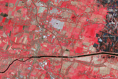
After new hot gas flows began to appear, workers started relocating families and were injured in the process. The workers were taken to a local hospital to undergo treatment for severe burns. In Siring Barat, 319 more families have been displaced and in Kelurahan Jatirejo, 262 new families are also going to be affected by the new flows of gas. Protesting families took to the streets demanding compensations, which in turn added more delays to the already stressed detour road for Jalan Raya Porong and the The Porong-Gempol toll road.
The government has stated that their heart is with the people, although the cabinet meeting on how to disburse the compensation has been delayed until further notice. Local official, Saiful Ilah, signed a statement announcing that "The government is going to defend the people of Siring." After this announcement all protests came to an end and traffic flow returned to normal an hour later.
New mudflows spots have begun in April 2010, this time on Porong Highway, which is the main road linking Surabaya
Surabaya
Surabaya is Indonesia's second-largest city with a population of over 2.7 million , and the capital of the province of East Java...
with Probolinggo
Probolinggo
Probolinggo is a city on the north coast of East Java, Indonesia.Like most of northern East Java, the city has a large Madurese population in addition to many ethnically Javanese people...
and islands to the east including Bali
Bali
Bali is an Indonesian island located in the westernmost end of the Lesser Sunda Islands, lying between Java to the west and Lombok to the east...
, despite roadway thickening and strengthening. A new highway is planned to replace this one however are held up by land acquisition issues. The main railway also runs by the area, which is in danger of explosions due to seepage of methane and ignition could come from something as simple as a tossed cigarette.
As of June 2009, the residents had received less than 20% of the suggested compensation. By mid-2010, reimbursement payments for victims have not been fully settled, and legal actions against the company have stalled. It is worth mentioning that the owner of the energy company, Aburizal Bakrie
Aburizal Bakrie
In this Indonesian name, the name "Bakrie" is a family name, and the person should be referred to by the family name "Bakrie".Aburizal Bakrie is an Indonesian entrepreneur and politician.- Family business :...
was the Coordinating Minister for People's Welfare at the time of the disaster. He is now the chairman of one of the most influential political parties in Indonesia.
Revived controversy
Out of the three hypotheses on the cause of the Lusi mud volcano, the hydro fracturing hypothesis appeared to be the one most debated. On 23 October 2008 a public relations agency in London, acting for one of the oil well's owners, started to widely publicise what it described as "new facts" on the origin of the mud volcano, which were subsequently presented at an American Association of Petroleum GeologistsAmerican Association of Petroleum Geologists
The American Association of Petroleum Geologists is one of the world's largest professional geological societies with over 31,000 members as of 2007. The AAPG works to advance the science of geology , to promote technology, and to inspire high professional conduct...
conference in Cape Town
Cape Town
Cape Town is the second-most populous city in South Africa, and the provincial capital and primate city of the Western Cape. As the seat of the National Parliament, it is also the legislative capital of the country. It forms part of the City of Cape Town metropolitan municipality...
, South Africa
South Africa
The Republic of South Africa is a country in southern Africa. Located at the southern tip of Africa, it is divided into nine provinces, with of coastline on the Atlantic and Indian oceans...
on 28 October 2008 (see next section).
The assertion of the geologists and drillers from Energi Mega Persada was that "At a recent Geological Society of London Conference, we provided authoritative new facts that make it absolutely clear that drilling could not have been the trigger of LUSI." Other verbal reports of the conference in question indicated that the assertion was by no means accepted uncritically, and that when the novel data is published, it is certain to be scrutinised closely.
In 2009, this well data was finally released and published in the Journal of Marine and Petroleum Geology for the scientific community uses by the geologists and drillers from Energi Mega Persada. It is a common practice in the oil and gas industry to closely guard their drilling and geologic information, and the company involved is of no exception. After such release, however, future scientific research on Lusi should have an access to a set of credible data and not as constraint as early authors were in their limited and questionable quality data to back their claims.
After hearing the (revised) arguments from both sides for the cause of the mud volcano at the American Association of Petroleum Geologists International Convention in Cape Town in October 2008, the vast majority of the conference session audience present (consisting of AAPG oil and gas professionals) voted in favor of the view that the Lusi (Sidoarjo) mudflow had been induced by drilling. On the basis of the arguments presented, 42 out of the 74 scientists came to the conclusion that drilling was entirely responsible, while 13 felt that a combination of drilling and earthquake activity was to blame. Only 3 thought that the earthquake was solely responsible, and 16 geoscientists believed that the evidence was inconclusive.
The report of the debate and its outcomes was published in AAPG Explorer Magazine. The article stated that the voting process was a decision by the moderator and only reflected opinions of a group of individuals in the session room at that time and in no way endorsed by the association. It further cautioned readers not to consider the voting result in any way as a scientific validation.
On the possible trigger of Lusi mud volcano, a group of geologists and drilling engineers from the oil company countered the hydro fracturing hypothesis. They suggested that analysis based on the well data showed that the well was safe and pressure in the well bore was below the critical pressure. It is therefore unlikely that the well was fractured as charged. Their paper also published data and well information for the first time to the scientific communities as opinions and technical papers up to that time lacked accurate well data and were forced to rely on a number of assumptions.
In February 2010, a group led by experts from Britain's
United Kingdom
The United Kingdom of Great Britain and Northern IrelandIn the United Kingdom and Dependencies, other languages have been officially recognised as legitimate autochthonous languages under the European Charter for Regional or Minority Languages...
Durham University
Durham University
The University of Durham, commonly known as Durham University, is a university in Durham, England. It was founded by Act of Parliament in 1832 and granted a Royal Charter in 1837...
said the new clues
bolstered suspicions the catastrophe was caused by human error. In journal Marine and Petroleum Geology,
Professor Richard Davies, of the Centre for Research into Earth Energy Systems (CeREES)
Centre for Research into Earth Energy Systems (CeREES)
The Centre for Research into Earth Energy Systems is a Geo-Energy research centre at Durham University. The centre was formed in January 2006, and since then has won a research income of £1.3M per annum. The current Director of CeREES is Professor Jon Gluyas, co-author of textbook Petroleum...
, said that drillers, looking for gas
Natural gas
Natural gas is a naturally occurring gas mixture consisting primarily of methane, typically with 0–20% higher hydrocarbons . It is found associated with other hydrocarbon fuel, in coal beds, as methane clathrates, and is an important fuel source and a major feedstock for fertilizers.Most natural...
nearby, had made a series of mistakes. They had overestimated the pressure the well could tolerate, and had not placed protective casing around a section of open well. Then, after failing to find any gas, they hauled the drill
Drill
A drill or drill motor is a tool fitted with a cutting tool attachment or driving tool attachment, usually a drill bit or driver bit, used for drilling holes in various materials or fastening various materials together with the use of fasteners. The attachment is gripped by a chuck at one end of...
out while the hole was extremely unstable. By withdrawing the drill, they exposed the wellhole to a "kick" from pressurised water and gas from surrounding rock formation
Rock formation
This is a list of rock formations that include isolated, scenic, or spectacular surface rock outcrops. These formations are usually the result of weathering and erosion sculpting the existing rock...
s. The result was a volcano
Volcano
2. Bedrock3. Conduit 4. Base5. Sill6. Dike7. Layers of ash emitted by the volcano8. Flank| 9. Layers of lava emitted by the volcano10. Throat11. Parasitic cone12. Lava flow13. Vent14. Crater15...
-like inflow that the drillers tried in vain to stop.
In the same Marine and Petroleum Geology journal, the group of geologists and drilling engineers refuted the allegation showing that the “kick” maximum pressure were too low to fracture the rock formation. The well pressure analysis based on credible data showed that the well is stronger than the maximum pressure exerted on the well. This implied that the hydro fracturing hypothesis is likely to be incorrect. They further stated that the model developed by Prof. Davies is much too simplistic by not considering all the available dataset and information in its analysis.
The 2010 technical paper in this series of debate presents the first balanced overview on the anatomy of the Lusi mud volcanic system with particular emphasis on the critical uncertainties and their influence on the disaster. It showed the differences in the two hypotheses, the source of water and the current understanding on the subsurface geology below the mud volcano. It is obvious that more geological field studies and analysis based on factual data need to be done before any conclusion can be deduced on what actually caused Lusi mud volcano.
External links
- http://singingdove.com/2010/07/17/the-earth-bleeds-mud/
- Portal of Lapindo's Victims
- Bakrie & Brothers homepage
- Drilling 'caused Java mud volcano'
- High format pictures of the mud volcano presented by The Boston Globe
- Notes from Indonesian Geoscientist dedicated for the Sidoarjo mud flow
- http://www.crisp.nus.edu.sg/coverages/mudflowSatellite imagery and Google Earth kml satellite image overlays by CRISPCRISPCRISP may refer to:*C-language Reduced Instruction Set Processor*Chesapeake Regional Information System for our Patients*Complementary Randomized Integrated Sensing and Processing...
/ National University of SingaporeNational University of SingaporeThe National University of Singapore is Singapore's oldest university. It is the largest university in the country in terms of student enrollment and curriculum offered....
] - The EGU Newsletters, Issue 19 March 2007: Mud volcano in Java, known locally as 'Lusi' may continue to erupt for months and possibly years. p.5.
- updated information from Java
- Photo gallery of Sidoarjo mudflow