
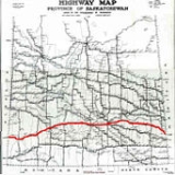
Saskatchewan Highway 1
Encyclopedia
Highway 1 is the Saskatchewan
section of the Trans-Canada Highway
mainland route. The total distance of the Trans-Canada Highway
in Saskatchewan
is 651.2 kilometres (404.6 mi). The highway traverses Saskatchewan from the western border with Alberta
, from Highway 1, to Manitoba
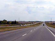
where it continues as Highway 1, PTH 1. The Trans–Canada Highway Act was passed on December 10, 1949. The Saskatchewan segment was completed August 21, 1957. The speed limit along the majority of the route is 110 kilometres per hour (70–mph) with urban area thoroughfares slowing to a speed of 90–100 kilometres per hour (55–65 mph). Freeway sections run through Swift Current, an 8-kilometer section east of Moose Jaw, and the Regina Ring Road
. Highway 1 serves as a major east-west transport route for commercial traffic. It is the main link between southern Saskatchewan's largest cities, and also serves as the province's main link to the neighbouring provinces of Alberta
(to the west) and Manitoba
(to the east).
The four-lane divided highway passes through three major urban centres of Saskatchewan, Regina
, Moose Jaw and Swift Current. A site in the Western Hemisphere Shorebird Reserve Network
, an internationally acclaimed shorebird conservation strategy, is at the village of Chaplin
approximately equal distance between Swift Current and Moose Jaw. Located southwest of the Trans–Canada is the Cypress Hills Interprovincial Park
, which features Fort Walsh
and the highest elevation of Saskatchewan. Highway 1 traverses ranch lands, the Missouri Coteau topographical area, and rolling prairie agricultural plains.
The highway generally runs west to east along the route, following parallel with the transcontinental Canadian Pacific Railway
route. The Trans–Canada Highway traverses historical settlement areas. The transcontinental railroad of 1885 brought settlers to southern Saskatchewan. Commemorative historical sites along the Trans–Canada Highway
mark the historical changes of the 72 years since the CPR
came through.
 The Minister of Mines and Resources held the first Federal-Provincial Conference regarding the Trans-Canada Highway in December, 1948. With consent from all provinces, the Trans–Canada Highway Act was passed on December 10, 1949. Following this a second Federal-Provincial Conference was held to bring together the final details for the agreement. The Highway Act aims for the completion of the Trans–Canada Highway route by December, 1956. The third Federal-Provincial Conference hold April 25, 1950 saw Ontario, Manitoba, British Columbia, Prince Edward Island, Saskatchewan and Alberta sign the agreement which provided federal funding for the proposed transcontinental highway. The shortest and most practical routes could be chosen by each province respectively, given that provinces adjacent to one another agree on the meeting locations. The transcontinental hard-surfaced two lane highway was to have pavement widths of 22 ft (7 m) and 24 ft (7 m); shoulder widths, low gradients and curvature; bridge clearances and sight distances; few railway grade crossings; and be able to bear load capacities of 9 tons an axle. As of 1950, 4119 mi (6,629 km) have been agreed to. By 1955, the The Trans–Canada Highway program had only seen 4580 mi (7,371 km) of highway completed in areas outside of Quebec. 1523 mi (2,451 km) of the paved 2853 miles (4,591.4 km) of the Canadian highway Trans–Canada highway system had been completed by November 1, 1955 to Trans–Canada Highway standards. Premier T.C. Douglas presided over the opening ceremonies on August 21, 1957, opening the 650 km (403.9 mi) Saskatchewan segment of the Trans–Canada Highway
The Special Projects Branch of the Department of Resources and Development administers the Trans–Canada highway Act checking specifications, and prior construction. The contributions from the Dominion Government to the provinces may be up to 50 per cent of the cost of construction approved by the Governor in council. The actual construction is controlled by each Provincial Highway Department respectively. The estimated length of mileage for Saskatchewan is 461 mi (741.9 km) of the total 4933 mi (7,938.9 km).
1957 saw the Saskatchewan portion of the Trans–Canada Highway come to completion, the first province to finish their section in Canada. The year 1962 saw the entire Canadian 7821 km (4,860 mi) highway completed which came to a total expenditure of $1.4 billion (about $18.26 billion today). The last of the highway between Moosomin
and Wapella
was twinned and opened on November 6, 2008 providing a completely twinned corridor. The total cost of twinning was $217 million with the Canadian government contributing $59 million.
 An Indian trail used by fur traders, and Red River carts pulling settlers effects was the first path between Moosomin
and Fort Ellice, Manitoba. The transcontinental CPR
paralleled this trail when coming through in the late 19th and early 20th centuries.
Provincial Highway 4, the precursor of the Trans–Canada Saskatchewan Highway 1 followed the surveyed grade of the transcontinental CPR
between the Alberta
and Manitoba
border. Travel along Provincial Highway 4 before the 1940s would have been travelling on the square following the township road allowances, barbed wire fencing and rail lines. As the surveyed township roads were the easiest to travel, the first highway
was designed on 90 degree right angle corners as the distance traversed the prairie along range roads and township roads. Two horse then eight horse scrapers maintained these early dirt roads.
One of the problems that came about was when the Manitoba survey met the Saskatchewan survey. The Manitoba survey allowed for 100 feet (30.5 m) road allowances placed east and west every 1 miles (1.6 km). This system was followed west of Manitoba until just north of Indian Head
. Whereas, the Saskatchewan survey conducted in 1887, allowed for 66 feet (20.1 m) road allowances and placed roads east and west every 2 miles (3.2 km). The two surveys needed a 2 miles (3.2 km) correction which took years to smooth out.
Agriculture is Saskatchewan's main industry and taking grain to elevators was first accomplished by horse and cart, to be replaced around World War I by truck travel. Long haul trucking flourished between 1950 and 1970, and the trans–Canada was completed across Canada by 1970. Since the 1970s, 17 times the number of grain trucks and 95 per cent of goods transported now are hauled by truck across the Saskatchewan.
 From the Alberta border (eastbound from Medicine Hat and Calgary
, Highway 1 is a four–lane divided highway with a speed limit of 110 kilometre per hour (70 mph). (Short stretches through the infrequent urban areas are at 90–100 kilometre per hour (55–65 mph) though) At Regina
, the highway meets the city in the south and has two official courses: through the city along Albert Street north to Victoria Avenue, then east, or on the Trans–Canada Bypass around the southeastern portion of the city. The bypass section is a controlled-access highway and is often called the Ring Road. Traffic continuing east along the Trans–Canada Highway exits at Victoria Avenue. After Regina, Highway 1 continues onward to Brandon
and Winnipeg
.
, Alberta
. Travelling east, the highway begins near Walsh, Alberta and crosses into Saskatchewan entering into the Rural Municipality (R.M.)
of Maple Creek
which was established December 10, 1917. (A rural municipality (R.M.)
was an elected governing system providing essential services such as police, fire, health, education and infrastructure services for rural residents. Historically, community residents could pay taxes or supply a couple days per quarter section labour constructing roads, bridges, and fireguards instead of paying taxes.) Maple Creek
, a town of 2,198 residents (2006 census), was established in 1883 and is located 8 kilometres south of the Trans-Canada Highway 1 via Highway 21
.
The next R.M.
is Piapot No 110
and a ghost town of Sidewood an early ranching area of Saskatchewan. Sidewood served residents between 1911 and 1952. Piapot No 110
first provided infrastructure improvements for this rural area in 1913 and is now an administrative division for a rural population of 392 residents. The small village of Piapot
has a southerly access to Highway 1 also via Highway 614
.
The village of Tompkins
, and the town of Gull Lake
are among the communities of R.M.
of Gull Lake No 139
. Both Tompkins
with its 173 residents and Gull Lake
serving 965 residents have their own municipal government. Gull Lake is an older community establishing its post office April 1, 1889. The south Saskatchewan region, an early ranching area was home to the 76 Ranch. The ranch house, constructed in 1888, is now the Gull Lake School Division office. Within Gull Lake No 139
, which was created in 1913, are several wind turbine generators which can be seen when traversing the Trans–Canada Highway.
A neighbouring village of Webb
with its population of 44 is situated within the next R.M.
of Webb No 138
just 2 kilometres (1.2 mi) south of Highway 1. Webb No 138
incorporated on December 13, 1909 providing road construction and maintenance. The post office was set up in Webb on March 1, 1908.
becomes the next R.M.
to travel through and here the unincorporated area
s of Beverley and Java are the next communities along the route. Both of these communities are enumerated as a part of RM
bringing its population to 1,587 residents. December 12, 1910 saw the incorporation of the RM of Swift Current No 137
. The highway runs through three cities on the way from Alberta to Manitoba, of which Swift Current is the first. Swift Current was first established in the North West Territories
in 1883 and has risen to a population of 14,946.
The original route of this highway was via Chaplin Street through Swift Current. The Trans-Canada became a four lane expressway in 1968, and the new route went past Swift Current to the north. Motels, shopping malls and fast food enterprises located along the highway route. Subdivisions and neighbourhoods now extend past the highway, so again highway 1 traverses Swift Current.
Excelsior No 166
R.M.
is the next rural governing body out of Swift Current which encompasses the community of Waldeck
directly on Highway 1 at the junction of Saskatchewan Highway 628
. Rush Lake
is 4 kilometres north of the highway. 1903 first saw Rush Lake become established, soon followed in 1906 by Waldeck, and 1909 for the RM
in this area.
The town of Herbert
with its post office established in 1904 has 742 residents now. Herbert once renowned as having ‘The
World’s Choicest Wheat Lands’ is at the junction of the Trans–Canada and Saskatchewan Highway 612
. Morse, as well as Ernfold are unincorporated areas which adds their populations to the 435 residents of R.M.
Morse No 165
. Morse is immediately north of Highway 1 at the intersection with Highway 644
. The Morse Museum and Cultural Center celebrates pioneer history in a 1912 brick school house. Saskatchewan's third biggest grain marketing point in Saskatchewan as of 1912, continued on this route by setting a record for shipping 2-1/4 million bushels of wheat in 1915. Morse has erected large cattails for their roadside attraction. Ernfold
is at the western edge of the separation of the east and west bound lanes of the Trans–Canada. The western route is about 15.3 km (9.5 mi) in length, and the eastern route is about 14.7 km (9.1 mi) long, before the highway comes together again.
Uren is the first community arrived at within Chaplin No 164
. Uren bustled between 1911 and 1961. Chaplin
, at the intersection of Route 1 and Highways 19
and 58
, was established in 1907. It is an unincorporated area which adds its population to the 138 residents (2006 census) of Chaplin No 164
. An American Avocet as well as Piping Plover are large statues built by the roadside commemorating the world famous bird sanctuary at Chaplin, Saskatchewan
. Valjean, and Secretan are also too small to have their own municipal governments and they are located along the highway proper. Valjean supported a post office between 1912 and 1968, whereas Secretan's post office survived from 1911 to 1970.
Wheatlands No 163
established in 1909 features the communities of Parkbeg as well as Mortlach. Parkbeg, an unincorporated area, had a post office established in the North West Territories
in 1896. Parkbeg is now located on Trans–Canada 1 east, a segment which is 16.5 kilometres in length. The Trans–Canada west is 13.3 mi (21.4 km) long and is about 2 km (1 mi) north of Parkbeg. Mortlach, a village of 254 people, is about 0.8 mi (1.3 km) south of the highway and established its post office just months before Saskatchewan became a province in 1905. Four major pipelines, TransCanada, Conoco, South Saskatchewan Pipeline, and Trans Gas find their home in Wheatlands RM
.
There is only one community along the highway within R.M.
Caron No 162
, which is Caronport
. The village of Caronport, 919 residents in 2006, did not receive a post office until 1947, but the RM
was serving the area since 1912. Local Improvement District (L.I.D.) #9 started making area improvements as early as 1904.
 Moose Jaw, also called "Little Chicago", is a city of 32,132 along the Trans–Canada. Capone's Car, Moose Family and Mac the Moose
are all large roadside attractions of Moose Jaw
. Moose Jaw Trolley Company (1912) is still an operating electric cable trolleys offering tours of Moose Jaw. Temple Gardens Mineral Spa Resort
, Tunnels of Moose Jaw, and History of Transportation Western Development Museum. are major sites of interest of this city. The juncture of the Moose Jaw River and Thunder Creek produced the best source of water for steam engines, and Moose Jaw became the CPR
divisional point
. AgPro Inland Grain Terminal operated by Saskatchewan Wheat Pool. These large capacity concrete grain terminals are replacing the smaller grain elevators which were numerous along the highway, sentinels of most communities along the route. Improved technology for harvest, transport and road construction have made the large inland terminals more viable economically. The rural governing body around Moose Jaw is Moose Jaw No. 161
which serves 1,228 residents (2006 census) which includes the Moose Jaw, Canadian Forces Base. Meat-processing plants, salt, potash, urea fertilizer, anhydrous ammonia and ethanol producers abound in this area with easy transport access to the Trans–Canada Highway.
Belle Plaine
, an unincorporated area, is within Pense No 160
. The RM
serves only 490 residents as of 2006.
 Sherwood No 159
is the R.M.
of the western perimeter around the capital city of Regina
. Regina, Saskatchewan's capital city is the second largest city of the province of Saskatchewan
with the 2006 census counting its population at 179,246 people. Sherwood R.M. provides essential services to 1,075 residents. As Regina expands, it annexes land from Sherwood No 159
.
Edenwold No 158
is the R.M.
east of Regina comprising White City
, as well as Balgonie
along the highway proper. Edenwold No 158
serves 3,611 residents. As Regina grows eastward, it annexes land from this RM. White City
a town of 1,113 residents could also be considered a census subdivision of Regina. Balgonie
an unincorporated area first established its post office in 1883. It is now situated at the intersections of Saskatchewan Highway 46
, 364
, 10
, and the Trans–Canada.
St. Joseph's
is a hamlet on Highway 1 and is a part of South Qu'appelle No 157
, the next R.M.
along the way. The town of Qu'Appelle
(624 residents in 2006) had historic beginnings with fur trading posts in this area, and is located within this R.M.
. Qu'Appelle was first named Troy, and was an administrative centre of the North West Territories
.
Indian Head
, a town with a population of 1,634, is within Indian Head No 156
along with the ghost town of Dingley and the town Sintaluta
. Sintaluta has a population of 98. Indian Head
has erected a large sculpture of an Indian Head at the side of the road.
Indian Head
features the historical Bell Farm
which was a large farming enterprise of 53000 acres (214.5 km²). Pioneer homesteaders in the early 1900s farmed quarter section homesteads which were 160 acre (0.6474976 km²) in size. This was a 1/2 mile by 1/2 mile (0.8 km by 0.8 km) farm.
Wolseley
, a town of 782, is within the area of Wolseley No 155
. The town of Wolseley is home to heritage properties such as the Provincial Court House building was constructed in 1893 and is the oldest surviving Court House building in the province. The Town Hall/Opera House, built in 1906 is a classic building and is used for all sorts of community events. A 1904 Queen Anne revival-style home is now the Grenfell 'Adare' Museum. This home built by Mr. Edward Fitzgerald was built on a large property which has been annexed by Grenfell
.
Elcapo No 154
contains the urban communities of Grenfell
, Oakshela
and Broadview
. Grenfell has a population of 947, and Broadview 611. Grenfell is home to a 14,700 tonne inland concrete terminal as well as a large grain elevator located at the CPR
line. Oakshela
, an unincorporated area, is the only municipality served by the RM
. The town of Broadview
was an 1882 Canadian Pacific Railway
divisional point. The Broadview Museum houses heritage of Broadview and area.
The town of Whitewood
, 869 residents in 2006, was first established as Whitewood Station, North West Territories
in 1883. Dr. Rudolph Meyer led a group of French Counts to the area of Whitewood
in the 1880s to develop a community similar to the communities for nobility in Europe. Merchant's Bank Heritage Center is a heritage building of Whitewood
which celebrates its link to the French Counts of St. Hubert. The next RM along the way is Willowdale No. 153
which nestles Percival, and Burrows within its population. Burrows is located at the junction of Highway 637
.
 Wapella
, an incorporated town, located within the Martin
, 339 rural residents.
Next along the way are Moosomin, Saskatchewan
, Rotave, and Fleming, Saskatchewan
all within the Moosomin No 121
R.M. The town of Moosomin, Saskatchewan
hosts 2,257 residents at the junction of Saskatchewan Highway 8
, 1, and 709
.
The Trans–Canada highway across Saskatchewan finally finishes up before the Manitoba
-Saskatchewan
border at Maryfield No. 91
.
features Fort Walsh
and the highest elevation of Saskatchewan. Cypress Hills is accessed just 62 kilometres south west of Highway 1. This area is known for its rolling with some steep hills and ravines.
Piapot Creek, Bear Creek and Skull Creek are near the Bench also known as the Cypress Hills plateau. After leaving the Maple Creek Plain, there is the Gull Lake Plain. Oil producing wells dot the landscape along with clumps of trees, sand hills, prairie grasses and wind turbines producing wind energy.
Swift Current was originally founded at Riviere Au Courant which translates in English to Swift Current. The Swift Current Plateau is a prairie grasslands area. The Chaplin Plain is the next grassland ecoregion, and Highway 1 is just to the north of Chaplin Lake which is situated on a huge bed of salt, producing a saline lake. The Western Hemispheric Shorebird Reserve a large shorebird conservation area is located on Chaplin Lake, and is renowned internationally. This area between Swift Current to Moose Jaw is considered to be part of the Missouri Coteau topographical area (extending south to the United States
).
The area to the south of Parkbeg is termed the Coteau Hills. Besant Regional Park and Campground is located west of Caronport
. The Dirt Hills, a grasslands ecoregion are west of Moose Jaw. The city of Moose Jaw arose at the junction of Moose Jaw River and Thunder Creek. The Wakamow Valley (administered by the Wakamow Valley Authority
) has been developed with trails, playgrounds, and picnic areas. Nicole Flats Nature Area (Buffalo Pound Provincial Park) is a preserved feature of the area. Both Moose Jaw and Regina
are situated upon moist mixed grassland ecoregions, specifically called the Regina Plain. Regina
is located south of the junction of the Wascana and Qu'Appelle Rivers, and the area is now called Wascana Lake. Aspen parkland prairie is east of Regina
. The Moose Mountain upland ecoregion is east of Regina and south of the Qu'Appelle River.
Fairly Lake is located within the town of Wolseley
. The lake was created because the CPR dammed up Wolf Creek to provide water for steam locomotives. Grenfell Regional Park is located west of Grenfell
.
Echo Valley, and Katepwa Point are two neighbouring provincial parks near Broadview
. Kipling Plain gives rise to the topographical feature called the Squirrel Hills and further to the east the Wood Hills. Moosomin Regional Park, is located to the south of the Trans–Canada highway in the Pipestone Valley on the shores of Moosomin Lake. The Melville Plain is the remaining ecoregion along the Trans–Canada highway before the Manitoba
border.
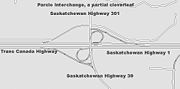
is a proposed 4 lane twinned
highway connector road linking two National Highway System routes as a part of the Asia-Pacific Gateway and Corridor Initiative (APGCI). Highway 1 and Saskatchewan Highway 11
will be linked by this new route west of Regina.
Saskatchewan
Saskatchewan is a prairie province in Canada, which has an area of . Saskatchewan is bordered on the west by Alberta, on the north by the Northwest Territories, on the east by Manitoba, and on the south by the U.S. states of Montana and North Dakota....
section of the Trans-Canada Highway
Trans-Canada Highway
The Trans-Canada Highway is a federal-provincial highway system that joins the ten provinces of Canada. It is, along with the Trans-Siberian Highway and Australia's Highway 1, one of the world's longest national highways, with the main route spanning 8,030 km...
mainland route. The total distance of the Trans-Canada Highway
Trans-Canada Highway
The Trans-Canada Highway is a federal-provincial highway system that joins the ten provinces of Canada. It is, along with the Trans-Siberian Highway and Australia's Highway 1, one of the world's longest national highways, with the main route spanning 8,030 km...
in Saskatchewan
Saskatchewan
Saskatchewan is a prairie province in Canada, which has an area of . Saskatchewan is bordered on the west by Alberta, on the north by the Northwest Territories, on the east by Manitoba, and on the south by the U.S. states of Montana and North Dakota....
is 651.2 kilometres (404.6 mi). The highway traverses Saskatchewan from the western border with Alberta
Alberta
Alberta is a province of Canada. It had an estimated population of 3.7 million in 2010 making it the most populous of Canada's three prairie provinces...
, from Highway 1, to Manitoba
Manitoba
Manitoba is a Canadian prairie province with an area of . The province has over 110,000 lakes and has a largely continental climate because of its flat topography. Agriculture, mostly concentrated in the fertile southern and western parts of the province, is vital to the province's economy; other...
where it continues as Highway 1, PTH 1. The Trans–Canada Highway Act was passed on December 10, 1949. The Saskatchewan segment was completed August 21, 1957. The speed limit along the majority of the route is 110 kilometres per hour (70–mph) with urban area thoroughfares slowing to a speed of 90–100 kilometres per hour (55–65 mph). Freeway sections run through Swift Current, an 8-kilometer section east of Moose Jaw, and the Regina Ring Road
Ring road
A ring road, orbital motorway, beltway, circumferential highway, or loop highway is a road that encircles a town or city...
. Highway 1 serves as a major east-west transport route for commercial traffic. It is the main link between southern Saskatchewan's largest cities, and also serves as the province's main link to the neighbouring provinces of Alberta
Alberta
Alberta is a province of Canada. It had an estimated population of 3.7 million in 2010 making it the most populous of Canada's three prairie provinces...
(to the west) and Manitoba
Manitoba
Manitoba is a Canadian prairie province with an area of . The province has over 110,000 lakes and has a largely continental climate because of its flat topography. Agriculture, mostly concentrated in the fertile southern and western parts of the province, is vital to the province's economy; other...
(to the east).
The four-lane divided highway passes through three major urban centres of Saskatchewan, Regina
Regina, Saskatchewan
Regina is the capital city of the Canadian province of Saskatchewan. The city is the second-largest in the province and a cultural and commercial centre for southern Saskatchewan. It is governed by Regina City Council. Regina is the cathedral city of the Roman Catholic and Romanian Orthodox...
, Moose Jaw and Swift Current. A site in the Western Hemisphere Shorebird Reserve Network
Western Hemisphere Shorebird Reserve Network
The Western Hemisphere Shorebird Reserve Network is a conservation strategy targeting shorebirds in the Americas launched in 1985. Its aim is to protect the nesting, breeding and staging habitats of migratory shorebirds...
, an internationally acclaimed shorebird conservation strategy, is at the village of Chaplin
Chaplin, Saskatchewan
Chaplin is a rural village in Saskatchewan, Canada situated on the Trans-Canada Highway approximately 85 km from Moose Jaw and 90 km from Swift Current. The main industries of Chaplin are Saskatchewan Minerals and farming/ ranching. Chaplin consists of eight streets, two crescents, and...
approximately equal distance between Swift Current and Moose Jaw. Located southwest of the Trans–Canada is the Cypress Hills Interprovincial Park
Cypress Hills Interprovincial Park
Cypress Hills Interprovincial Park is an interprovincial park straddling the southern Alberta-Saskatchewan border, located southeast of Medicine Hat...
, which features Fort Walsh
Fort Walsh
Fort Walsh is a National Historic Site of Canada that was a North-West Mounted Police fort and the site of the Cypress Hills Massacre. Administered by Parks Canada, it forms a constituent part of Cypress Hills Interprovincial Park....
and the highest elevation of Saskatchewan. Highway 1 traverses ranch lands, the Missouri Coteau topographical area, and rolling prairie agricultural plains.
The highway generally runs west to east along the route, following parallel with the transcontinental Canadian Pacific Railway
Canadian Pacific Railway
The Canadian Pacific Railway , formerly also known as CP Rail between 1968 and 1996, is a historic Canadian Class I railway founded in 1881 and now operated by Canadian Pacific Railway Limited, which began operations as legal owner in a corporate restructuring in 2001...
route. The Trans–Canada Highway traverses historical settlement areas. The transcontinental railroad of 1885 brought settlers to southern Saskatchewan. Commemorative historical sites along the Trans–Canada Highway
Trans-Canada Highway
The Trans-Canada Highway is a federal-provincial highway system that joins the ten provinces of Canada. It is, along with the Trans-Siberian Highway and Australia's Highway 1, one of the world's longest national highways, with the main route spanning 8,030 km...
mark the historical changes of the 72 years since the CPR
Canadian Pacific Railway
The Canadian Pacific Railway , formerly also known as CP Rail between 1968 and 1996, is a historic Canadian Class I railway founded in 1881 and now operated by Canadian Pacific Railway Limited, which began operations as legal owner in a corporate restructuring in 2001...
came through.
Origins
The Special Projects Branch of the Department of Resources and Development administers the Trans–Canada highway Act checking specifications, and prior construction. The contributions from the Dominion Government to the provinces may be up to 50 per cent of the cost of construction approved by the Governor in council. The actual construction is controlled by each Provincial Highway Department respectively. The estimated length of mileage for Saskatchewan is 461 mi (741.9 km) of the total 4933 mi (7,938.9 km).
1957 saw the Saskatchewan portion of the Trans–Canada Highway come to completion, the first province to finish their section in Canada. The year 1962 saw the entire Canadian 7821 km (4,860 mi) highway completed which came to a total expenditure of $1.4 billion (about $18.26 billion today). The last of the highway between Moosomin
Moosomin, Saskatchewan
-Climate:-Moosomin in popular culture:* The Guess Who has a song called "Runnin' Back to Saskatoon"; it also mentions Moose Jaw and Moosomin.-Notable people from Moosomin:...
and Wapella
Wapella, Saskatchewan
Wapella is a village of 354 located Northwest of Moosomin on the Trans-Canada Highway.-Demographics:-Notable natives:Cyril Edel Leonoff is the grandson of Edel Brotman, a homesteader and rabbi of the Wapella, Saskatchewan, farm colony, 1889-1906....
was twinned and opened on November 6, 2008 providing a completely twinned corridor. The total cost of twinning was $217 million with the Canadian government contributing $59 million.
History
Moosomin, Saskatchewan
-Climate:-Moosomin in popular culture:* The Guess Who has a song called "Runnin' Back to Saskatoon"; it also mentions Moose Jaw and Moosomin.-Notable people from Moosomin:...
and Fort Ellice, Manitoba. The transcontinental CPR
Canadian Pacific Railway
The Canadian Pacific Railway , formerly also known as CP Rail between 1968 and 1996, is a historic Canadian Class I railway founded in 1881 and now operated by Canadian Pacific Railway Limited, which began operations as legal owner in a corporate restructuring in 2001...
paralleled this trail when coming through in the late 19th and early 20th centuries.
Provincial Highway 4, the precursor of the Trans–Canada Saskatchewan Highway 1 followed the surveyed grade of the transcontinental CPR
Canadian Pacific Railway
The Canadian Pacific Railway , formerly also known as CP Rail between 1968 and 1996, is a historic Canadian Class I railway founded in 1881 and now operated by Canadian Pacific Railway Limited, which began operations as legal owner in a corporate restructuring in 2001...
between the Alberta
Alberta
Alberta is a province of Canada. It had an estimated population of 3.7 million in 2010 making it the most populous of Canada's three prairie provinces...
and Manitoba
Manitoba
Manitoba is a Canadian prairie province with an area of . The province has over 110,000 lakes and has a largely continental climate because of its flat topography. Agriculture, mostly concentrated in the fertile southern and western parts of the province, is vital to the province's economy; other...
border. Travel along Provincial Highway 4 before the 1940s would have been travelling on the square following the township road allowances, barbed wire fencing and rail lines. As the surveyed township roads were the easiest to travel, the first highway
Roads in Saskatchewan
Saskatchewan, the middle of Canada's three prairie provinces, has an area of and population of 990,212 , mostly living in the southern half of the province....
was designed on 90 degree right angle corners as the distance traversed the prairie along range roads and township roads. Two horse then eight horse scrapers maintained these early dirt roads.
One of the problems that came about was when the Manitoba survey met the Saskatchewan survey. The Manitoba survey allowed for 100 feet (30.5 m) road allowances placed east and west every 1 miles (1.6 km). This system was followed west of Manitoba until just north of Indian Head
Indian Head, Saskatchewan
Indian Head is a town in southeast Saskatchewan, Canada, east of Regina. The town is directly north of the Trans-Canada Highway. The town is known for its federally-operated Prairie Farm Rehabilitation Administration experimental farm and tree nursery that produces seedlings for shelter...
. Whereas, the Saskatchewan survey conducted in 1887, allowed for 66 feet (20.1 m) road allowances and placed roads east and west every 2 miles (3.2 km). The two surveys needed a 2 miles (3.2 km) correction which took years to smooth out.
Agriculture is Saskatchewan's main industry and taking grain to elevators was first accomplished by horse and cart, to be replaced around World War I by truck travel. Long haul trucking flourished between 1950 and 1970, and the trans–Canada was completed across Canada by 1970. Since the 1970s, 17 times the number of grain trucks and 95 per cent of goods transported now are hauled by truck across the Saskatchewan.
Speed Limits
Calgary
Calgary is a city in the Province of Alberta, Canada. It is located in the south of the province, in an area of foothills and prairie, approximately east of the front ranges of the Canadian Rockies...
, Highway 1 is a four–lane divided highway with a speed limit of 110 kilometre per hour (70 mph). (Short stretches through the infrequent urban areas are at 90–100 kilometre per hour (55–65 mph) though) At Regina
Regina, Saskatchewan
Regina is the capital city of the Canadian province of Saskatchewan. The city is the second-largest in the province and a cultural and commercial centre for southern Saskatchewan. It is governed by Regina City Council. Regina is the cathedral city of the Roman Catholic and Romanian Orthodox...
, the highway meets the city in the south and has two official courses: through the city along Albert Street north to Victoria Avenue, then east, or on the Trans–Canada Bypass around the southeastern portion of the city. The bypass section is a controlled-access highway and is often called the Ring Road. Traffic continuing east along the Trans–Canada Highway exits at Victoria Avenue. After Regina, Highway 1 continues onward to Brandon
Brandon, Manitoba
Brandon is the second largest city in Manitoba, Canada, and is located in the southwestern area of the province. Brandon is the largest city in the Westman region of Manitoba. The city is located along the Assiniboine River. Spruce Woods Provincial Park and CFB Shilo are a relatively short distance...
and Winnipeg
Winnipeg
Winnipeg is the capital and largest city of Manitoba, Canada, and is the primary municipality of the Winnipeg Capital Region, with more than half of Manitoba's population. It is located near the longitudinal centre of North America, at the confluence of the Red and Assiniboine Rivers .The name...
.
Alberta to Swift Current
Travelling west along the highway on the Alberta side, Highway 1 reaches CalgaryCalgary
Calgary is a city in the Province of Alberta, Canada. It is located in the south of the province, in an area of foothills and prairie, approximately east of the front ranges of the Canadian Rockies...
, Alberta
Alberta
Alberta is a province of Canada. It had an estimated population of 3.7 million in 2010 making it the most populous of Canada's three prairie provinces...
. Travelling east, the highway begins near Walsh, Alberta and crosses into Saskatchewan entering into the Rural Municipality (R.M.)
Rural municipality
A rural municipality, often abbreviated RM, is a form of municipality in the Canadian provinces of Manitoba and Saskatchewan, perhaps best comparable to counties or townships in the western United States...
of Maple Creek
Maple Creek No. 111, Saskatchewan
This article is about the rural municipality in Canada. For other places with the same name, see Maple Creek Maple Creek No. 111 is a rural municipality of 1,167 rural residents in the southwestern part of Saskatchewan, Canada. The main economic industry is ranching. The RM was incorporated...
which was established December 10, 1917. (A rural municipality (R.M.)
Rural municipality
A rural municipality, often abbreviated RM, is a form of municipality in the Canadian provinces of Manitoba and Saskatchewan, perhaps best comparable to counties or townships in the western United States...
was an elected governing system providing essential services such as police, fire, health, education and infrastructure services for rural residents. Historically, community residents could pay taxes or supply a couple days per quarter section labour constructing roads, bridges, and fireguards instead of paying taxes.) Maple Creek
Maple Creek, Saskatchewan
-History:After the North-West Mounted Police had been established at Fort Walsh, settlers began to explore the Cypress Hills area, living along the creeks and doing small-scale ranching. The Department of the Interior was operating a First Nations farm on the Maple Creek, a few miles south from...
, a town of 2,198 residents (2006 census), was established in 1883 and is located 8 kilometres south of the Trans-Canada Highway 1 via Highway 21
Saskatchewan Highway 21
Highway 21 is a highway in the Canadian province of Saskatchewan. It runs from Montana Secondary Highway 233 at the United States border near Willow Creek to Highway 950/Highway 919 within the Meadow Lake Provincial Park. Highway 21 is about 722 km long.Highway 21 passes through the major...
.
The next R.M.
Rural municipality
A rural municipality, often abbreviated RM, is a form of municipality in the Canadian provinces of Manitoba and Saskatchewan, perhaps best comparable to counties or townships in the western United States...
is Piapot No 110
Piapot No. 110, Saskatchewan
Piapot No. 110 is a rural municipality in the Canadian province of Saskatchewan, located in the southwestern region of the province.-Demographics:In 2006, the Rural municipality had a population of 392 in 190 dwellings, a -7.5% decrease from 2001...
and a ghost town of Sidewood an early ranching area of Saskatchewan. Sidewood served residents between 1911 and 1952. Piapot No 110
Piapot No. 110, Saskatchewan
Piapot No. 110 is a rural municipality in the Canadian province of Saskatchewan, located in the southwestern region of the province.-Demographics:In 2006, the Rural municipality had a population of 392 in 190 dwellings, a -7.5% decrease from 2001...
first provided infrastructure improvements for this rural area in 1913 and is now an administrative division for a rural population of 392 residents. The small village of Piapot
Piapot, Saskatchewan
Piapot is a small village located in the southwest part of the province of Saskatchewan, Canada. Once a thriving community, it has seen a steady decline since the 1950s and in the present day it resembles a ghost town. The hotel and saloon had been closed since June 2006 but has reopened in May...
has a southerly access to Highway 1 also via Highway 614
Saskatchewan Highway 614
Highway 614 is a highway in the Canadian province of Saskatchewan. It runs from Highway 18 near Loomis to Highway 1 near Piapot. Highway 614 is about 110 km long....
.
The village of Tompkins
Tompkins, Saskatchewan
Tompkins is a village in the southwestern portion of the Canadian province of Saskatchewan. The village is located between Maple Creek and Swift Current, on the Trans-Canada Highway. The 2006 census put the population of Tompkins at 173...
, and the town of Gull Lake
Gull Lake, Saskatchewan
-History:The history of the Gull Lake community dates back to 1906, when a development company Conrad and Price acquired and surveyed the town site and subdivided it into blocks. Unlike most other towns located along the C.P.R. main line, Gull Lake was not planned and established by the railroad....
are among the communities of R.M.
Rural municipality
A rural municipality, often abbreviated RM, is a form of municipality in the Canadian provinces of Manitoba and Saskatchewan, perhaps best comparable to counties or townships in the western United States...
of Gull Lake No 139
Gull Lake No. 139, Saskatchewan
This article is about the rural municipality in Canada. For other places with the same name, see Gull LakeGull Lake No. 139 is a rural municipality of 221 rural residents in the southwestern region of Saskatchewan, Canada. The RM was incorporated January 1, 1913...
. Both Tompkins
Tompkins, Saskatchewan
Tompkins is a village in the southwestern portion of the Canadian province of Saskatchewan. The village is located between Maple Creek and Swift Current, on the Trans-Canada Highway. The 2006 census put the population of Tompkins at 173...
with its 173 residents and Gull Lake
Gull Lake, Saskatchewan
-History:The history of the Gull Lake community dates back to 1906, when a development company Conrad and Price acquired and surveyed the town site and subdivided it into blocks. Unlike most other towns located along the C.P.R. main line, Gull Lake was not planned and established by the railroad....
serving 965 residents have their own municipal government. Gull Lake is an older community establishing its post office April 1, 1889. The south Saskatchewan region, an early ranching area was home to the 76 Ranch. The ranch house, constructed in 1888, is now the Gull Lake School Division office. Within Gull Lake No 139
Gull Lake No. 139, Saskatchewan
This article is about the rural municipality in Canada. For other places with the same name, see Gull LakeGull Lake No. 139 is a rural municipality of 221 rural residents in the southwestern region of Saskatchewan, Canada. The RM was incorporated January 1, 1913...
, which was created in 1913, are several wind turbine generators which can be seen when traversing the Trans–Canada Highway.
A neighbouring village of Webb
Webb, Saskatchewan
- See also :* List of communities in Saskatchewan* Villages of Saskatchewan* Paradise Hill Airport-External links:********-Footnotes:...
with its population of 44 is situated within the next R.M.
Rural municipality
A rural municipality, often abbreviated RM, is a form of municipality in the Canadian provinces of Manitoba and Saskatchewan, perhaps best comparable to counties or townships in the western United States...
of Webb No 138
Webb No. 138, Saskatchewan
This article is about the rural municipality in Canada. For other places with the same name, see WebbWebb No. 138, Saskatchewan is a rural municipality of 556 rural residents in the southwestern part of Saskatchewan, Canada. The RM was incorporated December 9, 1912...
just 2 kilometres (1.2 mi) south of Highway 1. Webb No 138
Webb No. 138, Saskatchewan
This article is about the rural municipality in Canada. For other places with the same name, see WebbWebb No. 138, Saskatchewan is a rural municipality of 556 rural residents in the southwestern part of Saskatchewan, Canada. The RM was incorporated December 9, 1912...
incorporated on December 13, 1909 providing road construction and maintenance. The post office was set up in Webb on March 1, 1908.
Swift Current to Moose Jaw
Swift Current No 137Swift Current No. 137, Saskatchewan
Swift Current No. 137, Saskatchewan is a rural municipality of 1,587 residents in the southwestern part of Saskatchewan, Canada. It comprises the rural area that surrounds the city of Swift Current. The RM was incorporated December 12, 1910...
becomes the next R.M.
Rural municipality
A rural municipality, often abbreviated RM, is a form of municipality in the Canadian provinces of Manitoba and Saskatchewan, perhaps best comparable to counties or townships in the western United States...
to travel through and here the unincorporated area
Unincorporated area
In law, an unincorporated area is a region of land that is not a part of any municipality.To "incorporate" in this context means to form a municipal corporation, a city, town, or village with its own government. An unincorporated community is usually not subject to or taxed by a municipal government...
s of Beverley and Java are the next communities along the route. Both of these communities are enumerated as a part of RM
Swift Current No. 137, Saskatchewan
Swift Current No. 137, Saskatchewan is a rural municipality of 1,587 residents in the southwestern part of Saskatchewan, Canada. It comprises the rural area that surrounds the city of Swift Current. The RM was incorporated December 12, 1910...
bringing its population to 1,587 residents. December 12, 1910 saw the incorporation of the RM of Swift Current No 137
Swift Current No. 137, Saskatchewan
Swift Current No. 137, Saskatchewan is a rural municipality of 1,587 residents in the southwestern part of Saskatchewan, Canada. It comprises the rural area that surrounds the city of Swift Current. The RM was incorporated December 12, 1910...
. The highway runs through three cities on the way from Alberta to Manitoba, of which Swift Current is the first. Swift Current was first established in the North West Territories
Territorial evolution of Canada
The federation of Canada was created in 1867 when three colonies of British North America were united. One of these colonies split into two new provinces, three other colonies joined later...
in 1883 and has risen to a population of 14,946.
The original route of this highway was via Chaplin Street through Swift Current. The Trans-Canada became a four lane expressway in 1968, and the new route went past Swift Current to the north. Motels, shopping malls and fast food enterprises located along the highway route. Subdivisions and neighbourhoods now extend past the highway, so again highway 1 traverses Swift Current.
Excelsior No 166
Excelsior No. 166, Saskatchewan
The Rural Municipality of Excelsior No. 166, Saskatchewan was originally called Waldeck No. 166, Saskatchewan and is now named Excelsior as of January 30, 1910. The original founding date of Pipestone was December 12, 1910 Up until December 31, 1967 the R.M. of Vermillion Hills No. 195 was to the...
R.M.
Rural municipality
A rural municipality, often abbreviated RM, is a form of municipality in the Canadian provinces of Manitoba and Saskatchewan, perhaps best comparable to counties or townships in the western United States...
is the next rural governing body out of Swift Current which encompasses the community of Waldeck
Waldeck, Saskatchewan
Waldeck is a village of 300 northeast of Swift Current, Saskatchewan on the Trans-Canada Highway. Waldeck is situated in the Swift Current River Valley, which is quite barren and has only a few trees along the Swift Current Creek.-Demographics:...
directly on Highway 1 at the junction of Saskatchewan Highway 628
Saskatchewan Highway 628
Highway 628 is a highway in the Canadian province of Saskatchewan. It is in two segments. The southern segment runs from Highway 18 near Glen McPherson to Highway 43 near Pambrun, and the northern segment runs from Highway 1 near Waldeck to Highway 4 near Stewart Valley...
. Rush Lake
Rush Lake, Saskatchewan
-Area statistics:*Dominion Land Survey Section 1 Township 17 Range 11 W3*Time zone UTC-6 North: Beechy West: Swift Current Rush Lake East: Morse South: Braddock -External links:***...
is 4 kilometres north of the highway. 1903 first saw Rush Lake become established, soon followed in 1906 by Waldeck, and 1909 for the RM
Excelsior No. 166, Saskatchewan
The Rural Municipality of Excelsior No. 166, Saskatchewan was originally called Waldeck No. 166, Saskatchewan and is now named Excelsior as of January 30, 1910. The original founding date of Pipestone was December 12, 1910 Up until December 31, 1967 the R.M. of Vermillion Hills No. 195 was to the...
in this area.
The town of Herbert
Herbert, Saskatchewan
-External links:* http://www.virtualmuseum.ca/pm.php?id=story_line&lg=English&fl=&ex=00000155&sl=2346&pos=1* http://www.townofherbertsk.ca/herbert/index.html...
with its post office established in 1904 has 742 residents now. Herbert once renowned as having ‘The
World’s Choicest Wheat Lands’ is at the junction of the Trans–Canada and Saskatchewan Highway 612
Saskatchewan Highway 612
Highway 612 is a highway in the Canadian province of Saskatchewan. It runs from Highway 1 near Herbert to Township Road 192 near Gouldtown. Highway 612 is about 20 km long.Highway 612 also connects with Highway 645....
. Morse, as well as Ernfold are unincorporated areas which adds their populations to the 435 residents of R.M.
Rural municipality
A rural municipality, often abbreviated RM, is a form of municipality in the Canadian provinces of Manitoba and Saskatchewan, perhaps best comparable to counties or townships in the western United States...
Morse No 165
Morse No. 165, Saskatchewan
This article is about the rural municipality in Canada. For other places with the same name, see MorseMorse No. 165, Saskatchewan is a rural municipality of 435 rural residents in the southwestern part of Saskatchewan, Canada. The RM was incorporated December 11, 1911...
. Morse is immediately north of Highway 1 at the intersection with Highway 644
Saskatchewan Highway 644
Highway 644 is a highway in the Canadian province of Saskatchewan. It runs from Highway 1 near Morse to Highway 42 near Riverhurst. Highway 644 is about 62 km long.Highway 644 also passes near the communities of Glen Kerr and Log Valley....
. The Morse Museum and Cultural Center celebrates pioneer history in a 1912 brick school house. Saskatchewan's third biggest grain marketing point in Saskatchewan as of 1912, continued on this route by setting a record for shipping 2-1/4 million bushels of wheat in 1915. Morse has erected large cattails for their roadside attraction. Ernfold
Ernfold, Saskatchewan
- See also :* List of communities in Saskatchewan* Villages of Saskatchewan-External links:*******-Footnotes:...
is at the western edge of the separation of the east and west bound lanes of the Trans–Canada. The western route is about 15.3 km (9.5 mi) in length, and the eastern route is about 14.7 km (9.1 mi) long, before the highway comes together again.
Uren is the first community arrived at within Chaplin No 164
Chaplin No. 164, Saskatchewan
-Area statistics:*Lat 50.416765762°*Long -106.584534688*Time zone UTC-6-External links:********- References :...
. Uren bustled between 1911 and 1961. Chaplin
Chaplin, Saskatchewan
Chaplin is a rural village in Saskatchewan, Canada situated on the Trans-Canada Highway approximately 85 km from Moose Jaw and 90 km from Swift Current. The main industries of Chaplin are Saskatchewan Minerals and farming/ ranching. Chaplin consists of eight streets, two crescents, and...
, at the intersection of Route 1 and Highways 19
Saskatchewan Highway 19
Highway 19 is a highway in the Canadian province of Saskatchewan connecting Highway 15 northern extremity near Hawarden to Highway 18 at the southern extremity near Mankota....
and 58
Saskatchewan Highway 58
Highway 58 is an oiled surface highway in the Canadian province of Saskatchewan which handles approximately 100 vehicles per day. It runs from Highway 18 3 kilometers west of Fir Mountain until Highway 1/Highway 19 near Chaplin in the South-Central area of the province. Highway 58 is about 132...
, was established in 1907. It is an unincorporated area which adds its population to the 138 residents (2006 census) of Chaplin No 164
Chaplin No. 164, Saskatchewan
-Area statistics:*Lat 50.416765762°*Long -106.584534688*Time zone UTC-6-External links:********- References :...
. An American Avocet as well as Piping Plover are large statues built by the roadside commemorating the world famous bird sanctuary at Chaplin, Saskatchewan
Chaplin, Saskatchewan
Chaplin is a rural village in Saskatchewan, Canada situated on the Trans-Canada Highway approximately 85 km from Moose Jaw and 90 km from Swift Current. The main industries of Chaplin are Saskatchewan Minerals and farming/ ranching. Chaplin consists of eight streets, two crescents, and...
. Valjean, and Secretan are also too small to have their own municipal governments and they are located along the highway proper. Valjean supported a post office between 1912 and 1968, whereas Secretan's post office survived from 1911 to 1970.
Wheatlands No 163
Wheatlands No. 163, Saskatchewan
This article is about the rural municipality in Canada. For other places with the same name, see WheatlandWheatlands No. 163, Saskatchewan is a rural municipality of 164 rural residents in the southwestern part of Saskatchewan, Canada. The RM was incorporated December 13, 1909. Other localities...
established in 1909 features the communities of Parkbeg as well as Mortlach. Parkbeg, an unincorporated area, had a post office established in the North West Territories
Territorial evolution of Canada
The federation of Canada was created in 1867 when three colonies of British North America were united. One of these colonies split into two new provinces, three other colonies joined later...
in 1896. Parkbeg is now located on Trans–Canada 1 east, a segment which is 16.5 kilometres in length. The Trans–Canada west is 13.3 mi (21.4 km) long and is about 2 km (1 mi) north of Parkbeg. Mortlach, a village of 254 people, is about 0.8 mi (1.3 km) south of the highway and established its post office just months before Saskatchewan became a province in 1905. Four major pipelines, TransCanada, Conoco, South Saskatchewan Pipeline, and Trans Gas find their home in Wheatlands RM
Wheatlands No. 163, Saskatchewan
This article is about the rural municipality in Canada. For other places with the same name, see WheatlandWheatlands No. 163, Saskatchewan is a rural municipality of 164 rural residents in the southwestern part of Saskatchewan, Canada. The RM was incorporated December 13, 1909. Other localities...
.
There is only one community along the highway within R.M.
Rural municipality
A rural municipality, often abbreviated RM, is a form of municipality in the Canadian provinces of Manitoba and Saskatchewan, perhaps best comparable to counties or townships in the western United States...
Caron No 162
Caron No. 162, Saskatchewan
This article is about the rural municipality in Canada. For other places with the same name, see Caron Caron No. 162, Saskatchewan is a rural municipality of 500 rural residents in the southwestern part of Saskatchewan, Canada. The RM was incorporated December 9, 1912...
, which is Caronport
Caronport, Saskatchewan
Caronport is a village in the Canadian province of Saskatchewan. The village had a population of 919 in the Canada 2006 Census, and is located within Census Division 7. The village is located 21 kilometres west of Moose Jaw on the Trans-Canada Highway. As of the 2006 census, Caronport is, by...
. The village of Caronport, 919 residents in 2006, did not receive a post office until 1947, but the RM
Caron No. 162, Saskatchewan
This article is about the rural municipality in Canada. For other places with the same name, see Caron Caron No. 162, Saskatchewan is a rural municipality of 500 rural residents in the southwestern part of Saskatchewan, Canada. The RM was incorporated December 9, 1912...
was serving the area since 1912. Local Improvement District (L.I.D.) #9 started making area improvements as early as 1904.
Moose Jaw to Regina
Mac the moose
Mac the Moose is a fibreglass moose in Moose Jaw, Saskatchewan. It is claimed to be the world's largest moose at feet tall and a weight of approximately . The giant moose is important to the city of Moose Jaw because it was one of its first tourist attractions. Moose Jaw now has many tourist...
are all large roadside attractions of Moose Jaw
Moose Jaw, Saskatchewan
Moose Jaw is a city in south-central Saskatchewan, Canada on the Moose Jaw River. It is situated on the Trans-Canada Highway, west of Regina. Residents of Moose Jaw are known as Moose Javians. It is best known as a retirement and tourist city that serves as a hub to the hundreds of small towns...
. Moose Jaw Trolley Company (1912) is still an operating electric cable trolleys offering tours of Moose Jaw. Temple Gardens Mineral Spa Resort
Temple Gardens Mineral Spa Resort
The Temple Gardens Mineral Spa Resort is a 4 star , hotel located in downtown Moose Jaw, Saskatchewan, Canada. The resort features a roof top indoor/outdoor mineral pools, and is connected to Casino Moose Jaw. In 1910, drillers looking for oil hit the hot springs that service the hotel, remains...
, Tunnels of Moose Jaw, and History of Transportation Western Development Museum. are major sites of interest of this city. The juncture of the Moose Jaw River and Thunder Creek produced the best source of water for steam engines, and Moose Jaw became the CPR
Canadian Pacific Railway
The Canadian Pacific Railway , formerly also known as CP Rail between 1968 and 1996, is a historic Canadian Class I railway founded in 1881 and now operated by Canadian Pacific Railway Limited, which began operations as legal owner in a corporate restructuring in 2001...
divisional point
Divisional point
In Canada, a divisional point is a railway depot that includes more than just a basic siding or station.- Overview :In the coal and steam era, a divisional point would include such amenities as a substantial passenger station, freight and baggage sheds, a roundhouse, water tank, coaling and sanding...
. AgPro Inland Grain Terminal operated by Saskatchewan Wheat Pool. These large capacity concrete grain terminals are replacing the smaller grain elevators which were numerous along the highway, sentinels of most communities along the route. Improved technology for harvest, transport and road construction have made the large inland terminals more viable economically. The rural governing body around Moose Jaw is Moose Jaw No. 161
Moose Jaw No. 161, Saskatchewan
Moose Jaw No. 161 is a rural municipality in the Canadian province of Saskatchewan, located in the southern part of the province west of Regina in SARM Division No...
which serves 1,228 residents (2006 census) which includes the Moose Jaw, Canadian Forces Base. Meat-processing plants, salt, potash, urea fertilizer, anhydrous ammonia and ethanol producers abound in this area with easy transport access to the Trans–Canada Highway.
Belle Plaine
Belle Plaine, Saskatchewan
-See also:*Highway 642*Highway 1*Qu'Appelle River Dam*Saskferco-External links:*********...
, an unincorporated area, is within Pense No 160
Pense No. 160, Saskatchewan
This article is about the rural municipality in Canada. For other places with the same name, see Pense Pense No. 160, Saskatchewan is a rural municipality of 490 rural residents in the southeastern part of Saskatchewan, Canada. The RM was incorporated January 1, 1913. As of 1923, the population...
. The RM
Pense No. 160, Saskatchewan
This article is about the rural municipality in Canada. For other places with the same name, see Pense Pense No. 160, Saskatchewan is a rural municipality of 490 rural residents in the southeastern part of Saskatchewan, Canada. The RM was incorporated January 1, 1913. As of 1923, the population...
serves only 490 residents as of 2006.
Regina to Manitoba
Sherwood No. 159, Saskatchewan
Sherwood Rural Municipality Number 159 is a rural municipality in southeastern Saskatchewan, Canada. It encircles and is an exurb of the city of Regina, the provincial capital. Also within the borders of Sherwood is the separately governed village of Grand Coulee...
is the R.M.
Rural municipality
A rural municipality, often abbreviated RM, is a form of municipality in the Canadian provinces of Manitoba and Saskatchewan, perhaps best comparable to counties or townships in the western United States...
of the western perimeter around the capital city of Regina
Regina, Saskatchewan
Regina is the capital city of the Canadian province of Saskatchewan. The city is the second-largest in the province and a cultural and commercial centre for southern Saskatchewan. It is governed by Regina City Council. Regina is the cathedral city of the Roman Catholic and Romanian Orthodox...
. Regina, Saskatchewan's capital city is the second largest city of the province of Saskatchewan
Saskatchewan
Saskatchewan is a prairie province in Canada, which has an area of . Saskatchewan is bordered on the west by Alberta, on the north by the Northwest Territories, on the east by Manitoba, and on the south by the U.S. states of Montana and North Dakota....
with the 2006 census counting its population at 179,246 people. Sherwood R.M. provides essential services to 1,075 residents. As Regina expands, it annexes land from Sherwood No 159
Sherwood No. 159, Saskatchewan
Sherwood Rural Municipality Number 159 is a rural municipality in southeastern Saskatchewan, Canada. It encircles and is an exurb of the city of Regina, the provincial capital. Also within the borders of Sherwood is the separately governed village of Grand Coulee...
.
Edenwold No 158
Edenwold No. 158, Saskatchewan
Edenwold No. 158, Saskatchewan is a rural municipality of 3,611 rural residents in the southeastern part of Saskatchewan, Canada on the Trans Canada Highway. The RM was incorporated December 9, 1912...
is the R.M.
Rural municipality
A rural municipality, often abbreviated RM, is a form of municipality in the Canadian provinces of Manitoba and Saskatchewan, perhaps best comparable to counties or townships in the western United States...
east of Regina comprising White City
White City, Saskatchewan
White City is a commuter town in the Canadian province of Saskatchewan. White City is 10 kilometres east of Regina on the Trans-Canada Highway. The town is primarily populated by urban professionals and young families who work in Regina. The town's motto is "Country Living."-History:White City...
, as well as Balgonie
Balgonie, Saskatchewan
-Sports:Home of Team Selzer, World Women's Curling Silver Medalists, and consistently competitive high school volleyball and soccer programs.-References:...
along the highway proper. Edenwold No 158
Edenwold No. 158, Saskatchewan
Edenwold No. 158, Saskatchewan is a rural municipality of 3,611 rural residents in the southeastern part of Saskatchewan, Canada on the Trans Canada Highway. The RM was incorporated December 9, 1912...
serves 3,611 residents. As Regina grows eastward, it annexes land from this RM. White City
White City, Saskatchewan
White City is a commuter town in the Canadian province of Saskatchewan. White City is 10 kilometres east of Regina on the Trans-Canada Highway. The town is primarily populated by urban professionals and young families who work in Regina. The town's motto is "Country Living."-History:White City...
a town of 1,113 residents could also be considered a census subdivision of Regina. Balgonie
Balgonie, Saskatchewan
-Sports:Home of Team Selzer, World Women's Curling Silver Medalists, and consistently competitive high school volleyball and soccer programs.-References:...
an unincorporated area first established its post office in 1883. It is now situated at the intersections of Saskatchewan Highway 46
Saskatchewan Highway 46
Highway 46 is a highway in the Canadian province of Saskatchewan. It runs from the Ring Road at Regina to Highway 1 near Balgonie. Highway 46 is about 19 km long. The highway used to only exist as a gravel grid road from Regina to Pilot Butte...
, 364
Saskatchewan Highway 364
Highway 364 is a highway in the Canadian province of Saskatchewan. It runs from Highway 1 near Balgonie to Highway 10 near Edgeley. Highway 364 is about 36 km long....
, 10
Saskatchewan Highway 10
Highway 10 is a provincial paved undivided highway in the Canadian province of Saskatchewan. It runs from Highway 1 near Balgonie until it transitions into PTH 5 at the Manitoba border. Highway 10 is about 228 km long....
, and the Trans–Canada.
St. Joseph's
St. Joseph's, Saskatchewan
St. Joseph's, Saskatchewan is a hamlet located at section 5 township 18 range 16 West of the 2nd meridian. It can be accessed on Sk Hwy 1, the TransCanada and is a part of South Qu'appelle No 157 R.M..-External links:*****...
is a hamlet on Highway 1 and is a part of South Qu'appelle No 157
South Qu'appelle No. 157, Saskatchewan
This article is about the rural municipality in Canada. For other places with the same name, see Qu'appelleSouth Qu'appelle No. 157, Saskatchewan is a rural municipality of 1,066 rural residents in the southeastern part of Saskatchewan, Canada. The RM was incorporated August 6, 1884...
, the next R.M.
Rural municipality
A rural municipality, often abbreviated RM, is a form of municipality in the Canadian provinces of Manitoba and Saskatchewan, perhaps best comparable to counties or townships in the western United States...
along the way. The town of Qu'Appelle
Qu'Appelle, Saskatchewan
Qu'Appelle, Saskatchewan, is a small village and formerly in ecclesiastical terms a city, with considerable historic significance located on Trans-Canada Highway and the Canadian Pacific Railway mainline, some east of the provincial capital of Regina.Qu'Appelle was for a time the terminus of the...
(624 residents in 2006) had historic beginnings with fur trading posts in this area, and is located within this R.M.
South Qu'appelle No. 157, Saskatchewan
This article is about the rural municipality in Canada. For other places with the same name, see Qu'appelleSouth Qu'appelle No. 157, Saskatchewan is a rural municipality of 1,066 rural residents in the southeastern part of Saskatchewan, Canada. The RM was incorporated August 6, 1884...
. Qu'Appelle was first named Troy, and was an administrative centre of the North West Territories
Territorial evolution of Canada
The federation of Canada was created in 1867 when three colonies of British North America were united. One of these colonies split into two new provinces, three other colonies joined later...
.
Indian Head
Indian Head, Saskatchewan
Indian Head is a town in southeast Saskatchewan, Canada, east of Regina. The town is directly north of the Trans-Canada Highway. The town is known for its federally-operated Prairie Farm Rehabilitation Administration experimental farm and tree nursery that produces seedlings for shelter...
, a town with a population of 1,634, is within Indian Head No 156
Indian Head No. 156, Saskatchewan
The Rural Municipality of Indian Head No. 156 is a rural municipality in the Canadian province of Saskatchewan. Indian Head No. 156 is located in South East Saskatchewan, in SARM division 1.-Communities:...
along with the ghost town of Dingley and the town Sintaluta
Sintaluta, Saskatchewan
Sintaluta is a small town in Indian Head, SK Rural Municipality No. 156. The current population of Sintaluta is approximately 98 people Sintaluta is a small town in Indian Head, SK Rural Municipality No. 156. The current population of Sintaluta is approximately 98 people Sintaluta is a small town...
. Sintaluta has a population of 98. Indian Head
Indian Head, Saskatchewan
Indian Head is a town in southeast Saskatchewan, Canada, east of Regina. The town is directly north of the Trans-Canada Highway. The town is known for its federally-operated Prairie Farm Rehabilitation Administration experimental farm and tree nursery that produces seedlings for shelter...
has erected a large sculpture of an Indian Head at the side of the road.
Indian Head
Indian Head, Saskatchewan
Indian Head is a town in southeast Saskatchewan, Canada, east of Regina. The town is directly north of the Trans-Canada Highway. The town is known for its federally-operated Prairie Farm Rehabilitation Administration experimental farm and tree nursery that produces seedlings for shelter...
features the historical Bell Farm
Bell Farm
Bell Farm is a heritage farm built in 1882 by Major Bell on ten miles square or at Indian Head. The Bell Farm Barn is amongst the ten top most endangered sites by the Heritage Canada Foundation.sp The round structure consisted of a silo which could be used also as a lookout tower. The silo had...
which was a large farming enterprise of 53000 acres (214.5 km²). Pioneer homesteaders in the early 1900s farmed quarter section homesteads which were 160 acre (0.6474976 km²) in size. This was a 1/2 mile by 1/2 mile (0.8 km by 0.8 km) farm.
Wolseley
Wolseley, Saskatchewan
-External links:** Encyclopedia of Saskatchewan...
, a town of 782, is within the area of Wolseley No 155
Wolseley No. 155, Saskatchewan
Wolseley No. 155, Saskatchewan is a rural municipality of 438 rural residents in the southeastern part of Saskatchewan, Canada. The residents are also a part of SARM Division No. 1, Yorkton—Melville Economic Region and Census Division No. 5, Saskatchewan. The RM was incorporated December 13, 1909...
. The town of Wolseley is home to heritage properties such as the Provincial Court House building was constructed in 1893 and is the oldest surviving Court House building in the province. The Town Hall/Opera House, built in 1906 is a classic building and is used for all sorts of community events. A 1904 Queen Anne revival-style home is now the Grenfell 'Adare' Museum. This home built by Mr. Edward Fitzgerald was built on a large property which has been annexed by Grenfell
Grenfell, Saskatchewan
Grenfell is a town in the Canadian province of Saskatchewan. European settlement began in 1882 before the Canadian Pacific Railway reached the site of the town; the post office was established in 1883. It is situated at the junction of Highway 47 and the Trans Canada Highway east of Regina, the...
.
Elcapo No 154
Elcapo No. 154, Saskatchewan
Elcapo No. 154, Saskatchewan is a rural municipality of 489 rural residents in the southeastern part of Saskatchewan, Canada. The residents of this area also belong to SARM Division No. 1 and Census Division No. 5, Saskatchewan. The RM was incorporated December 12, 1910. There are no localities...
contains the urban communities of Grenfell
Grenfell, Saskatchewan
Grenfell is a town in the Canadian province of Saskatchewan. European settlement began in 1882 before the Canadian Pacific Railway reached the site of the town; the post office was established in 1883. It is situated at the junction of Highway 47 and the Trans Canada Highway east of Regina, the...
, Oakshela
Oakshela, Saskatchewan
Oakshela is a hamlet in Saskatchewan, Canada. It was founded in the late 19th century by farmers and quickly became a flourishing small town. It once housed a post office, three stores, a school, a church and several families both within town and just outside of town.It also had a cemetery, which...
and Broadview
Broadview, Saskatchewan
Broadview is a community in Saskatchewan along the #1 highway, the Trans Canada Highway, east of the provincial capital city of Regina. The local economy is based mainly on agriculture.-History:...
. Grenfell has a population of 947, and Broadview 611. Grenfell is home to a 14,700 tonne inland concrete terminal as well as a large grain elevator located at the CPR
Canadian Pacific Railway
The Canadian Pacific Railway , formerly also known as CP Rail between 1968 and 1996, is a historic Canadian Class I railway founded in 1881 and now operated by Canadian Pacific Railway Limited, which began operations as legal owner in a corporate restructuring in 2001...
line. Oakshela
Oakshela, Saskatchewan
Oakshela is a hamlet in Saskatchewan, Canada. It was founded in the late 19th century by farmers and quickly became a flourishing small town. It once housed a post office, three stores, a school, a church and several families both within town and just outside of town.It also had a cemetery, which...
, an unincorporated area, is the only municipality served by the RM
Elcapo No. 154, Saskatchewan
Elcapo No. 154, Saskatchewan is a rural municipality of 489 rural residents in the southeastern part of Saskatchewan, Canada. The residents of this area also belong to SARM Division No. 1 and Census Division No. 5, Saskatchewan. The RM was incorporated December 12, 1910. There are no localities...
. The town of Broadview
Broadview, Saskatchewan
Broadview is a community in Saskatchewan along the #1 highway, the Trans Canada Highway, east of the provincial capital city of Regina. The local economy is based mainly on agriculture.-History:...
was an 1882 Canadian Pacific Railway
Canadian Pacific Railway
The Canadian Pacific Railway , formerly also known as CP Rail between 1968 and 1996, is a historic Canadian Class I railway founded in 1881 and now operated by Canadian Pacific Railway Limited, which began operations as legal owner in a corporate restructuring in 2001...
divisional point. The Broadview Museum houses heritage of Broadview and area.
The town of Whitewood
Whitewood, Saskatchewan
Whitewood is a town in the Canadian province of Saskatchewan. It is located approximately east of Regina on the Trans-Canada Highway Sk Hwy 1. It is situated at the crossroads of two major highways systems – the Trans-Canada, which runs east and west, and Sk Hwy 9, which runs north and south from...
, 869 residents in 2006, was first established as Whitewood Station, North West Territories
Territorial evolution of Canada
The federation of Canada was created in 1867 when three colonies of British North America were united. One of these colonies split into two new provinces, three other colonies joined later...
in 1883. Dr. Rudolph Meyer led a group of French Counts to the area of Whitewood
Whitewood, Saskatchewan
Whitewood is a town in the Canadian province of Saskatchewan. It is located approximately east of Regina on the Trans-Canada Highway Sk Hwy 1. It is situated at the crossroads of two major highways systems – the Trans-Canada, which runs east and west, and Sk Hwy 9, which runs north and south from...
in the 1880s to develop a community similar to the communities for nobility in Europe. Merchant's Bank Heritage Center is a heritage building of Whitewood
Whitewood, Saskatchewan
Whitewood is a town in the Canadian province of Saskatchewan. It is located approximately east of Regina on the Trans-Canada Highway Sk Hwy 1. It is situated at the crossroads of two major highways systems – the Trans-Canada, which runs east and west, and Sk Hwy 9, which runs north and south from...
which celebrates its link to the French Counts of St. Hubert. The next RM along the way is Willowdale No. 153
Willowdale No. 153, Saskatchewan
Willowdale No. 153, Saskatchewan is a rural municipality of 333 rural residents in the southeastern part of Saskatchewan, Canada. Residents also belong to SARM Division No. 1 and Census Division No. 5, Saskatchewan. The RM was incorporated January 1, 1913. No localities in this RM. The town of...
which nestles Percival, and Burrows within its population. Burrows is located at the junction of Highway 637
Saskatchewan Highway 637
Highway 637 is a highway in the Canadian province of Saskatchewan. It runs from Highway 10 near Dunleath to Highway 8/Highway 49 near Norquay. Highway 637 is about 87 km long....
.
Wapella, Saskatchewan
Wapella is a village of 354 located Northwest of Moosomin on the Trans-Canada Highway.-Demographics:-Notable natives:Cyril Edel Leonoff is the grandson of Edel Brotman, a homesteader and rabbi of the Wapella, Saskatchewan, farm colony, 1889-1906....
, an incorporated town, located within the Martin
Martin No. 122, Saskatchewan
Martin No. 122 is a rural municipality in the Canadian province of Saskatchewan, located to the north and south of the Trans-Canada Highway, approximately 200 kilometres east of Regina in SARM Division No. 1. The town of Wapella and the Ochapowace 71-26 First Nations Indian reserve both lie...
, 339 rural residents.
Next along the way are Moosomin, Saskatchewan
Moosomin, Saskatchewan
-Climate:-Moosomin in popular culture:* The Guess Who has a song called "Runnin' Back to Saskatoon"; it also mentions Moose Jaw and Moosomin.-Notable people from Moosomin:...
, Rotave, and Fleming, Saskatchewan
Fleming, Saskatchewan
-External links:*...
all within the Moosomin No 121
Moosomin No. 121, Saskatchewan
Moosomin No. 121, Saskatchewan is a rural municipality of 164 rural residents in the southeastern part of Saskatchewan, Canada. The RM was incorporated December 13, 1909. Residents are also a part of SARM Division No. 1, Census Division No. 5, Saskatchewan, and the Yorkton—Melville Economic Region...
R.M. The town of Moosomin, Saskatchewan
Moosomin, Saskatchewan
-Climate:-Moosomin in popular culture:* The Guess Who has a song called "Runnin' Back to Saskatoon"; it also mentions Moose Jaw and Moosomin.-Notable people from Moosomin:...
hosts 2,257 residents at the junction of Saskatchewan Highway 8
Saskatchewan Highway 8
Highway 8 is a highway in the Canadian province of Saskatchewan. It runs from North Dakota Highway 28 at the US border near Elmore until it transitions into Highway 982 just outside the Porcupine Provincial Forest...
, 1, and 709
Saskatchewan Highway 709
Highway 709 is a highway in the Canadian province of Saskatchewan. It runs from Highway 48 near Kipling to Highway 600.- Route description :Highway 709 begins east of Kipling. In Highway 709 intersects the Trans-Canada Highway at the town of Moosomin...
.
The Trans–Canada highway across Saskatchewan finally finishes up before the Manitoba
Manitoba
Manitoba is a Canadian prairie province with an area of . The province has over 110,000 lakes and has a largely continental climate because of its flat topography. Agriculture, mostly concentrated in the fertile southern and western parts of the province, is vital to the province's economy; other...
-Saskatchewan
Saskatchewan
Saskatchewan is a prairie province in Canada, which has an area of . Saskatchewan is bordered on the west by Alberta, on the north by the Northwest Territories, on the east by Manitoba, and on the south by the U.S. states of Montana and North Dakota....
border at Maryfield No. 91
Maryfield No. 91, Saskatchewan
Maryfield No. 91 is a rural municipality in south-eastern Saskatchewan, Canada encompassing 759.63 square kilometers in area. The rural municipality maintains it's office in the village Maryfield, Saskatchewan . The rural municipality in conjunction with the provincial government is in charge...
.
Geophysical features
Highway 1 travels through geographical sites of interest as well as conservation areas. The highway begins in a mixed grassland ecoregion known as Maple Creek Plain. The Great Sand Hills are north of Highway 1 and the Cypress Hills region is south of the highway. The Cypress Hills Interprovincial ParkCypress Hills Interprovincial Park
Cypress Hills Interprovincial Park is an interprovincial park straddling the southern Alberta-Saskatchewan border, located southeast of Medicine Hat...
features Fort Walsh
Fort Walsh
Fort Walsh is a National Historic Site of Canada that was a North-West Mounted Police fort and the site of the Cypress Hills Massacre. Administered by Parks Canada, it forms a constituent part of Cypress Hills Interprovincial Park....
and the highest elevation of Saskatchewan. Cypress Hills is accessed just 62 kilometres south west of Highway 1. This area is known for its rolling with some steep hills and ravines.
Piapot Creek, Bear Creek and Skull Creek are near the Bench also known as the Cypress Hills plateau. After leaving the Maple Creek Plain, there is the Gull Lake Plain. Oil producing wells dot the landscape along with clumps of trees, sand hills, prairie grasses and wind turbines producing wind energy.
Swift Current was originally founded at Riviere Au Courant which translates in English to Swift Current. The Swift Current Plateau is a prairie grasslands area. The Chaplin Plain is the next grassland ecoregion, and Highway 1 is just to the north of Chaplin Lake which is situated on a huge bed of salt, producing a saline lake. The Western Hemispheric Shorebird Reserve a large shorebird conservation area is located on Chaplin Lake, and is renowned internationally. This area between Swift Current to Moose Jaw is considered to be part of the Missouri Coteau topographical area (extending south to the United States
United States
The United States of America is a federal constitutional republic comprising fifty states and a federal district...
).
The area to the south of Parkbeg is termed the Coteau Hills. Besant Regional Park and Campground is located west of Caronport
Caronport, Saskatchewan
Caronport is a village in the Canadian province of Saskatchewan. The village had a population of 919 in the Canada 2006 Census, and is located within Census Division 7. The village is located 21 kilometres west of Moose Jaw on the Trans-Canada Highway. As of the 2006 census, Caronport is, by...
. The Dirt Hills, a grasslands ecoregion are west of Moose Jaw. The city of Moose Jaw arose at the junction of Moose Jaw River and Thunder Creek. The Wakamow Valley (administered by the Wakamow Valley Authority
Wakamow Valley Authority
The Wakamow Valley Authority is a conservation organization created by the Provincial Government of Saskatchewan in Canada and is dedicated to conserving the cultural and natural resources of the Wakamow Valley. The authorities activities include education, development and conservation...
) has been developed with trails, playgrounds, and picnic areas. Nicole Flats Nature Area (Buffalo Pound Provincial Park) is a preserved feature of the area. Both Moose Jaw and Regina
Regina, Saskatchewan
Regina is the capital city of the Canadian province of Saskatchewan. The city is the second-largest in the province and a cultural and commercial centre for southern Saskatchewan. It is governed by Regina City Council. Regina is the cathedral city of the Roman Catholic and Romanian Orthodox...
are situated upon moist mixed grassland ecoregions, specifically called the Regina Plain. Regina
Regina, Saskatchewan
Regina is the capital city of the Canadian province of Saskatchewan. The city is the second-largest in the province and a cultural and commercial centre for southern Saskatchewan. It is governed by Regina City Council. Regina is the cathedral city of the Roman Catholic and Romanian Orthodox...
is located south of the junction of the Wascana and Qu'Appelle Rivers, and the area is now called Wascana Lake. Aspen parkland prairie is east of Regina
Regina, Saskatchewan
Regina is the capital city of the Canadian province of Saskatchewan. The city is the second-largest in the province and a cultural and commercial centre for southern Saskatchewan. It is governed by Regina City Council. Regina is the cathedral city of the Roman Catholic and Romanian Orthodox...
. The Moose Mountain upland ecoregion is east of Regina and south of the Qu'Appelle River.
Fairly Lake is located within the town of Wolseley
Wolseley, Saskatchewan
-External links:** Encyclopedia of Saskatchewan...
. The lake was created because the CPR dammed up Wolf Creek to provide water for steam locomotives. Grenfell Regional Park is located west of Grenfell
Grenfell, Saskatchewan
Grenfell is a town in the Canadian province of Saskatchewan. European settlement began in 1882 before the Canadian Pacific Railway reached the site of the town; the post office was established in 1883. It is situated at the junction of Highway 47 and the Trans Canada Highway east of Regina, the...
.
Echo Valley, and Katepwa Point are two neighbouring provincial parks near Broadview
Broadview, Saskatchewan
Broadview is a community in Saskatchewan along the #1 highway, the Trans Canada Highway, east of the provincial capital city of Regina. The local economy is based mainly on agriculture.-History:...
. Kipling Plain gives rise to the topographical feature called the Squirrel Hills and further to the east the Wood Hills. Moosomin Regional Park, is located to the south of the Trans–Canada highway in the Pipestone Valley on the shores of Moosomin Lake. The Melville Plain is the remaining ecoregion along the Trans–Canada highway before the Manitoba
Manitoba
Manitoba is a Canadian prairie province with an area of . The province has over 110,000 lakes and has a largely continental climate because of its flat topography. Agriculture, mostly concentrated in the fertile southern and western parts of the province, is vital to the province's economy; other...
border.
Future plans
Pinkie RoadPinkie Road
Pinkie Road is a proposed 4 lane twinned highway connector road linking two National Highway System routes as a part of the Asia-Pacific Gateway and Corridor Initiative . Highway 1 and Highway 11 will be linked by this new route, west of Regina, Saskatchewan. The City of Regina, Sherwood No...
is a proposed 4 lane twinned
Dual carriageway
A dual carriageway is a class of highway with two carriageways for traffic travelling in opposite directions separated by a central reservation...
highway connector road linking two National Highway System routes as a part of the Asia-Pacific Gateway and Corridor Initiative (APGCI). Highway 1 and Saskatchewan Highway 11
Saskatchewan Highway 11
Highway 11 is a major north-south highway in Saskatchewan, Canada that connects the province's three largest cities: Regina, Saskatoon and Prince Albert. It is a structural pavement major arterial highway which is approximately long. It is also known as the Louis Riel Trail after the 19th century...
will be linked by this new route west of Regina.
Intersections from west to east
Books
- Prairie Memories. Webb History Book Committee. Webb, Saskatchewan: Webb History Book Committee, 1982.
External links
- Saskatchewan #1 Trans–Canada Highway
- Saskatchewan Highways Website–Highway Numbering
- Saskatchewan Road Map RV Itineraries
- Big Things of Canada, A Celebration of Community Monuments of Canada
- Navigating the Trans–Canada Highway
- Online Historical Map Digitization Project
- Saskatchewan City & Town Maps*Saskatchewan's Highway Network Government of Saskatchewan
- Trans–Canada Highway *Trans–Canada Highway
- Trans–Canada Highway Act
- Trans–Canada Netword
- Trans–Canada Highway Transport Canada