

Bodélé Depression
Encyclopedia
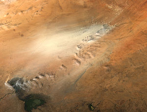
The Bodélé Depression located at the southern edge of the Sahara Desert in north central Africa
Africa
Africa is the world's second largest and second most populous continent, after Asia. At about 30.2 million km² including adjacent islands, it covers 6% of the Earth's total surface area and 20.4% of the total land area...
, is the lowest point in Chad
Chad
Chad , officially known as the Republic of Chad, is a landlocked country in Central Africa. It is bordered by Libya to the north, Sudan to the east, the Central African Republic to the south, Cameroon and Nigeria to the southwest, and Niger to the west...
. Dust storms
Dust storm
A dust / sand storm is a meteorological phenomenon common in arid and semi-arid regions. Dust storms arise when a gust front or other strong wind blows loose sand and dirt from a dry surface. Particles are transported by saltation and suspension, causing soil to move from one place and deposition...
from the Bodélé Depression occur on average about 100 days per year (Washington et al., 2005), one typical example being the massive dust storms that swept over West Africa
West Africa
West Africa or Western Africa is the westernmost region of the African continent. Geopolitically, the UN definition of Western Africa includes the following 16 countries and an area of approximately 5 million square km:-Flags of West Africa:...
and the Cape Verde Islands in February 2004. As the wind sweeps between the Tibesti
Tibesti Mountains
The Tibesti Mountains are a range of inactive volcanoes located on the northern edge of the Chad Basin in the Borkou- and Tibesti Region of northern Chad. The massif is one of the most prominent features of the Central-Sahara desert and covers an area of approximately 100,000 km². The northern...
and the Ennedi
Ennedi Plateau
The Ennedi Plateau, located in the North-East of Chad, in the Bourkou-Ennedi-Tibesti Region, is a sandstone bulwark in the middle of the Sahara. It is assailed by the sands on all sides, that encroach the deep valleys of the Ennedi...
Mountains in Northern Chad
Chad
Chad , officially known as the Republic of Chad, is a landlocked country in Central Africa. It is bordered by Libya to the north, Sudan to the east, the Central African Republic to the south, Cameroon and Nigeria to the southwest, and Niger to the west...
, it is channeled across the depression. The dry bowl that forms the depression is marked by a series of ephemeral lakes, many of which were last filled during wetter periods of the Holocene
Holocene
The Holocene is a geological epoch which began at the end of the Pleistocene and continues to the present. The Holocene is part of the Quaternary period. Its name comes from the Greek words and , meaning "entirely recent"...
.
Diatom
Diatom
Diatoms are a major group of algae, and are one of the most common types of phytoplankton. Most diatoms are unicellular, although they can exist as colonies in the shape of filaments or ribbons , fans , zigzags , or stellate colonies . Diatoms are producers within the food chain...
s from these fresh water lakes, once part of Mega-Lake Chad, now make up the surface of the depression and are the source material for the dust.
As the Sahara dried out over the last few thousand years, Mega-Lake Chad receded to the current position of Lake Chad
Lake Chad
Lake Chad is a historically large, shallow, endorheic lake in Africa, whose size has varied over the centuries. According to the Global Resource Information Database of the United Nations Environment Programme, it shrank as much as 95% from about 1963 to 1998; yet it also states that "the 2007 ...
in the south-west corner of Chad. In the mid-1960s, Lake Chad was about the size of Lake Erie
Lake Erie
Lake Erie is the fourth largest lake of the five Great Lakes in North America, and the tenth largest globally. It is the southernmost, shallowest, and smallest by volume of the Great Lakes and therefore also has the shortest average water residence time. It is bounded on the north by the...
. But persistent drought conditions associated with the great Sahel drought coupled with increased demand for fresh water
Fresh Water
Fresh Water is the debut album by Australian rock and blues singer Alison McCallum, released in 1972. Rare for an Australian artist at the time, it came in a gatefold sleeve...
for irrigation have reduced Lake Chad to about 5 percent of its former size. As the waters receded, the silt
Silt
Silt is granular material of a size somewhere between sand and clay whose mineral origin is quartz and feldspar. Silt may occur as a soil or as suspended sediment in a surface water body...
s and sediment
Sediment
Sediment is naturally occurring material that is broken down by processes of weathering and erosion, and is subsequently transported by the action of fluids such as wind, water, or ice, and/or by the force of gravity acting on the particle itself....
s resting on the lakebed were left to dry in the scorching African sun. The small grains of the diatomite are swept up by the strong wind gusts that occasionally blow over the region. Once heaved aloft, the Bodélé dust can be carried for hundreds or even thousands of kilometers. In winter, the depression produces an average of 1,200,000 tonnes of dust each day (Todd et al., 2007) .
Research published in the 25 March 2004 edition of Geophysical Research Letters
Geophysical Research Letters
Geophysical Research Letters is a semi-monthly peer reviewed scientific journal published by the American Geophysical Union that was established in 1974...
, which used images taken by the Moderate Resolution Imaging Spectroradiometer (MODIS), aboard NASA
NASA
The National Aeronautics and Space Administration is the agency of the United States government that is responsible for the nation's civilian space program and for aeronautics and aerospace research...
's Terra and Aqua satellites, indicated that storms move across the Bodélé Depression at about 47 km/h (29 mi/h)—two times faster than previously believed. The research also found that winds have to whip across the region at a minimum of 36 km/h (22 mi/h), to kick up a dust storm
Dust storm
A dust / sand storm is a meteorological phenomenon common in arid and semi-arid regions. Dust storms arise when a gust front or other strong wind blows loose sand and dirt from a dry surface. Particles are transported by saltation and suspension, causing soil to move from one place and deposition...
. The pattern of air flow is so common that the winds have scoured a straight path in the ground, marking its southwesterly flow.
Complementary research published in Geophysical Research Letters
Geophysical Research Letters
Geophysical Research Letters is a semi-monthly peer reviewed scientific journal published by the American Geophysical Union that was established in 1974...
by Richard Washington from the University of Oxford
University of Oxford
The University of Oxford is a university located in Oxford, United Kingdom. It is the second-oldest surviving university in the world and the oldest in the English-speaking world. Although its exact date of foundation is unclear, there is evidence of teaching as far back as 1096...
and Martin Todd (University of Sussex) has shown that these strong winds are part of feature now called the Bodele Low Level Jet. In the Reanalysis data sets such as ERA-40
ERA-40
ERA-40 is a ECMWF re-analysis of the global atmosphere and surface conditions for 45-years, over the period from September 1957 through August 2002 by ECMWF. Many sources of the meteorological observations were used, including radiosondes, balloons, aircraft, buoyes, satellites, scatterometers....
the wind shows up as a clear wind speed maximum at about 900 hPa (or roughly 1 km above the surface) near 18 N and 19 E. This jet maximum coincides with the exit gap of the North-easterlies between the Tibesti mountains and the Ennedi massif which lie 2600 m and 1000 m above the flat terrain in the Djourab Desert of Chad respectively. The effect of the Tibesti massif is clearly evident in creating a split in the low-level easterly flow north and south of these mountains. While the jet feature is pronounced over the Bodele, it is absent from other longitudes over west Africa along 18 N. It is therefore a feature which uniquely overlies the greater Bodele region, downwind of the mountains of Chad.
The Bodele Low Level Jet undergoes a marked seasonal cycle. It is active in the October–March period and relatively inactive from June–August. This timing closely matches the seasonality of dust emission from the Bodele. Individual dust storms in the Bodele were also shown in this research to coincide with a major strengthening of the Bodele Low Level Jet which, in turn, is associated with the ridging of the Libyan High, a feature of the subtropical High Pressure belt.
The same researchers who in 2004 more accurately determined the speed of wind through the depression also published in 2006 work showing that more than half of the dust needed for fertilizing the Amazon Rainforest
Amazon Rainforest
The Amazon Rainforest , also known in English as Amazonia or the Amazon Jungle, is a moist broadleaf forest that covers most of the Amazon Basin of South America...
is provided by the Bodélé depression. The research also shows that, contrary to what was previously thought, most of the Saharan dust that reaches the east coast of the United States
East Coast of the United States
The East Coast of the United States, also known as the Eastern Seaboard, refers to the easternmost coastal states in the United States, which touch the Atlantic Ocean and stretch up to Canada. The term includes the U.S...
originates from a single source—the Bodele depression.
In February 2005 the first field experiment, the Bodele Dust Experiment or BoDEx 2005, was carried out in the Bodele Depression. The experiment measured the surface winds and near surface winds, dust concentrations and the influence of dust on the radiation budget in the Bodele Depression for the first time . This work coincided with a major dust emission event during which the Bodele Low Level Jet sustained surface wind speeds of around 16 m/s. The core of the Bodele Low Level Jet was also mapped for the first time from the wind data and was shown to undergo a very marked diurnal cycle with peak winds occurring mid morning. During night time, the Bodele Low Level Jet flows over a near-surface inversion but quickly mixes down to the surface a few hours after sunrise once the intense surface heating induces turbulence in the lowest layers.
Dust from the Bodele may be seen as a simple coincidence of two key requirements for deflation: strong surface winds and erodible sediment. But recent research has argued that
long-term links exist between topography, wind, deflation and dust and that topography acts as the controlling agent ensuring the long term maintenance of this source. The spatial co-location of strong winds and dust is not simply fortuitous but results from a set of processes. Specifically:
- Contemporary deflation from the Bodele is delineated by topography such that wind stress, the maximum in dust output and the topographic depression are colocated.
- The topography of the Tibesti and Ennedi Mountains plays a key role in the generation of the Bodele Low Level Jet.
- Enhanced deflation from a stronger Bodele Low Level Jet during drier phases, such as the Last Glacial Maximum was probably sufficient to create or enhance a shallow lake populated by diatoms during wetter phases, such as the Holocene pluvial.
Wind conditions which deflate the erodible sediment now may have created the depression necessary for generating the erodible diatomite in the past. Instead of a simple coincidence of nature, the world’s largest source results from a system of processes operating over paleo timescales
The largest town associated with the Bodele dust source is Faya-Largeau
Faya-Largeau
Located in the Sahara, Faya's climate is classed as hot desert on the Köppen climate classification. It experiences hot winters and very hot summers with the peak average maximum temperature reaching in May and the average minimum reaching its lowest in January at . Rainfall averages out at about...
(17°55′00"N 19°7′00"E), located just to the north of the depression.