
Red Screes
Encyclopedia
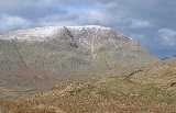
Red Screes is a fell
in the English
Lake District
, situated between the villages of Patterdale
and Ambleside
. It is an outlier of the Fairfield
group in the Eastern Fells
, but is separated from its neighbours by low col
s. This gives Red Screes an independence which is reflected in its prominence.
, a satellite of Dove Crag
. From the pass the long Scandale Beck runs south to Ambleside and the River Rothay. On the northern side Caiston Beck makes for Hartsop and Ullswater
. To the east of Red Screes is the motor road from Ambleside to Patterdale, reaching its summit at Kirkstone Pass
(1,485 ft). on the opposite side of Kirkstone Pass (east ) are the High Street
range of the Far Eastern Fells, beginning with Stony Cove Pike
and Thornthwaite Crag
. Running south from Kirkstone Pass and its summit inn
is the valley of Stock Ghyll which flows the Ambleside, joining the Rothay a few yards from the confluence with Scandale Beck. Kirkstone Beck flows north from the pass, joining Caiston Beck before reaching Hartsop. Thus the boundaries of Red Screes are formed symmetrically by four valleys, with the fell rising at the head of none of them.
The northern ridge of Red Screes passes over the subsidiary top of Middle Dodd
. This has little prominence, being more the point where the gradient of descent markedly increases, but Alfred Wainwright
in his Pictorial Guide to the Lakeland Fells
gave it the status of a separate fell and that convention is followed here. The long southern ridge has the equally notable top of Snarker Pike which was not given such a distinction. This is one of many reasons why Wainwrights differ from more logical hill lists
such as Hewitts, Nuttalls and Marilyns
.
The broad southern ridge runs for about two and a half miles before petering out on the outskirts of Ambleside. The lower slopes have been planted with many small areas of mixed woodland and are extensively compartmentalised by a vast array of dry stone walls. North of the summit the descending ridge narrows at Smallthwaite Band before widening again to the summit of Middle Dodd. From here the descent is steep and rough.
The western flanks are also rough, but the east displays two miles of screeslope, looming above almost the full length of Kirkstone Pass. It is from this view that the fell takes its name. Prominent on Ordnance Survey
maps is Kilnshaw Chimney, although on the ground this is just a narrow gully beneath the summit.
s are cut into the eastern face and between them a flat topped promontory juts out with the highest point on its northern edge. A number of large cairn
s have been formed and an Ordnance Survey triangulation column stands nearby. A few yards to the south is Red Screes Tarn, a small permanent waterbody with no plant life in evidence. A number of smaller pools can be found after rain. The panorama
is excellent, with a first-class view of the Far Eastern Fells
and the distant Coniston
, Bowfell
and Scafell
skyline of the Southern Fells
. The immediate views down the eastern face to the Kirkstone Inn are spectacular.
welded lapilli
-tuff
and sandstone
of the Lincomb Tarns Formation.
There is evidence of mining in Caiston Glen, with the mouth of a level opening about halfway up the beck. This was an unsuccessful trial for lead
and extends about 80 ft into the fellside. There is a further small working nearby. There are also the remains of a trial for copper
on the eastern flank, a 120 ft level being driven into the fell from close to the modern road.
Alfred Wainwright
's thoughts on the fell were as follows:
Fell
“Fell” is a word used to refer to mountains, or certain types of mountainous landscape, in Scandinavia, the Isle of Man, and parts of northern England.- Etymology :...
in the English
England
England is a country that is part of the United Kingdom. It shares land borders with Scotland to the north and Wales to the west; the Irish Sea is to the north west, the Celtic Sea to the south west, with the North Sea to the east and the English Channel to the south separating it from continental...
Lake District
Lake District
The Lake District, also commonly known as The Lakes or Lakeland, is a mountainous region in North West England. A popular holiday destination, it is famous not only for its lakes and its mountains but also for its associations with the early 19th century poetry and writings of William Wordsworth...
, situated between the villages of Patterdale
Patterdale
Patterdale is a small village and civil parish in the eastern part of the English Lake District in the Eden District of Cumbria, and the long valley in which they are found, also called the Ullswater Valley....
and Ambleside
Ambleside
Ambleside is a town in Cumbria, in North West England.Historically within the county of Westmorland, it is situated at the head of Windermere, England's largest lake...
. It is an outlier of the Fairfield
Fairfield (Lake District)
Fairfield is a fell in the English Lake District. It is the highest of a group of hills in the Eastern Fells, standing to the south of the Helvellyn range.-Topography:...
group in the Eastern Fells
Eastern Fells
The Eastern Fells are a group of hills in the English Lake District. Centred on Helvellyn they primarily comprise a north south ridge running between Ullswater and Lakeland's Central Valley.-Partition of the Lakeland Fells:...
, but is separated from its neighbours by low col
Mountain pass
A mountain pass is a route through a mountain range or over a ridge. If following the lowest possible route, a pass is locally the highest point on that route...
s. This gives Red Screes an independence which is reflected in its prominence.
Topography
Taking the form of a long upturned boat, Red Screes is a ridge running roughly north to south. Shorter saddles connecting to neighbouring fells are sent out amidships on either side. To the west Scandale Pass (1,690 ft) connects to Little Hart CragLittle Hart Crag
Little Hart Crag is a fell in the Lake District area of England. It stands at the head of Scandale, six kilometres north of Ambleside, at a height of 637 metres . It is an eastern outlier of Dove Crag in the Eastern Fells, although it does have 34 metres of prominence from that fell making it both...
, a satellite of Dove Crag
Dove Crag
Dove Crag is a fell in the English Lake District. Situated in the Eastern Fells of the national park, seven kilometres south-south-west of Glenridding, it reaches a height of 792 metres...
. From the pass the long Scandale Beck runs south to Ambleside and the River Rothay. On the northern side Caiston Beck makes for Hartsop and Ullswater
Ullswater
Ullswater is the second largest lake in the English Lake District, being approximately nine miles long and 0.75 miles wide with a maximum depth of slightly more than ....
. To the east of Red Screes is the motor road from Ambleside to Patterdale, reaching its summit at Kirkstone Pass
Kirkstone Pass
Kirkstone Pass is a mountain pass in the English Lake District, in the county of Cumbria. It is at an altitude of .This is the Lake District's highest pass that is open to motor traffic and it connects Ambleside in the Rothay Valley to Patterdale in the Ullswater Valley - the A592 road. In places,...
(1,485 ft). on the opposite side of Kirkstone Pass (east ) are the High Street
High Street (Lake District)
High Street is a fell in the English Lake District. At 828 metres , its summit is the highest point in the far eastern part of the national park. The fell is named after the Roman road which ran over the summit.-History and Naming:...
range of the Far Eastern Fells, beginning with Stony Cove Pike
Stony Cove Pike
Stony Cove Pike is a fell in the Far Eastern part of the English Lake District. It stands on the other side of the Kirkstone Pass from Red Screes, and is on the end of a ridge coming down from High Street...
and Thornthwaite Crag
Thornthwaite Crag
Thornthwaite Crag is a fell in the English Lake District, standing to the west of Haweswater Reservoir. It is a focal point of the Far Eastern Fells, standing at the head of several valleys.-Topography:...
. Running south from Kirkstone Pass and its summit inn
INN
InterNetNews is a Usenet news server package, originally released by Rich Salz in 1991, and presented at the Summer 1992 USENIX conference in San Antonio, Texas...
is the valley of Stock Ghyll which flows the Ambleside, joining the Rothay a few yards from the confluence with Scandale Beck. Kirkstone Beck flows north from the pass, joining Caiston Beck before reaching Hartsop. Thus the boundaries of Red Screes are formed symmetrically by four valleys, with the fell rising at the head of none of them.
The northern ridge of Red Screes passes over the subsidiary top of Middle Dodd
Middle Dodd
Middle Dodd is a fell in the English Lake District, an outlier of the Helvellyn range in the Eastern Fells. It stands above Kirkstone Pass on the road from Ullswater to Ambleside.-Topography:...
. This has little prominence, being more the point where the gradient of descent markedly increases, but Alfred Wainwright
Alfred Wainwright
Alfred Wainwright MBE was a British fellwalker, guidebook author and illustrator. His seven-volume Pictorial Guide to the Lakeland Fells, published between 1955 and 1966 and consisting entirely of reproductions of his manuscript, has become the standard reference work to 214 of the fells of the...
in his Pictorial Guide to the Lakeland Fells
Pictorial Guide to the Lakeland Fells
A Pictorial Guide to the Lakeland Fells is a series of seven books by A. Wainwright, detailing the fells of the Lake District in northwest England...
gave it the status of a separate fell and that convention is followed here. The long southern ridge has the equally notable top of Snarker Pike which was not given such a distinction. This is one of many reasons why Wainwrights differ from more logical hill lists
Hill lists in the British Isles
The mountains and hills of Great Britain, and to a lesser extent Ireland, are the subject of a considerable number of lists that categorise them by height, topographic prominence, or other criteria. They are commonly used as a basis for peak bagging, whereby hillwalkers attempt to reach all the...
such as Hewitts, Nuttalls and Marilyns
Marilyn (hill)
A Marilyn is a mountain or hill in the United Kingdom, Republic of Ireland or Isle of Man with a relative height of at least 150 metres , regardless of absolute height or other merit...
.
The broad southern ridge runs for about two and a half miles before petering out on the outskirts of Ambleside. The lower slopes have been planted with many small areas of mixed woodland and are extensively compartmentalised by a vast array of dry stone walls. North of the summit the descending ridge narrows at Smallthwaite Band before widening again to the summit of Middle Dodd. From here the descent is steep and rough.
The western flanks are also rough, but the east displays two miles of screeslope, looming above almost the full length of Kirkstone Pass. It is from this view that the fell takes its name. Prominent on Ordnance Survey
Ordnance Survey
Ordnance Survey , an executive agency and non-ministerial government department of the Government of the United Kingdom, is the national mapping agency for Great Britain, producing maps of Great Britain , and one of the world's largest producers of maps.The name reflects its creation together with...
maps is Kilnshaw Chimney, although on the ground this is just a narrow gully beneath the summit.
Summit and View
The summit area is a broad plateau with a dressing of grass and stones. Two unnamed corrieCirque
Cirque may refer to:* Cirque, a geological formation* Makhtesh, an erosional landform found in the Negev desert of Israel and Sinai of Egypt*Cirque , an album by Biosphere* Cirque Corporation, a company that makes touchpads...
s are cut into the eastern face and between them a flat topped promontory juts out with the highest point on its northern edge. A number of large cairn
Cairn
Cairn is a term used mainly in the English-speaking world for a man-made pile of stones. It comes from the or . Cairns are found all over the world in uplands, on moorland, on mountaintops, near waterways and on sea cliffs, and also in barren desert and tundra areas...
s have been formed and an Ordnance Survey triangulation column stands nearby. A few yards to the south is Red Screes Tarn, a small permanent waterbody with no plant life in evidence. A number of smaller pools can be found after rain. The panorama
Panorama
A panorama is any wide-angle view or representation of a physical space, whether in painting, drawing, photography, film/video, or a three-dimensional model....
is excellent, with a first-class view of the Far Eastern Fells
Far Eastern Fells
The Far Eastern Fells are a group of hills in the English Lake District. Reaching their highest point at High Street they occupy a broad area to the east of Ullswater and Kirkstone Pass. Much quieter than the central areas of Lakeland they offer in general easier but less exciting walking as the...
and the distant Coniston
Old Man of Coniston
The Old Man of Coniston is a fell in the Furness Fells in the English Lake District. It is high, and lies to the west of the village of Coniston and the lake of the same name, Coniston Water. The fell is sometimes known by the alternate name of Coniston Old Man, or simply The Old Man...
, Bowfell
Bowfell
Bowfell is a pyramid-shaped mountain lying at the heart of the English Lake District, in the Southern Fells area. It is the sixth highest mountain in the lakes and one of the most popular of the Lake District fells...
and Scafell
Scafell Pike
Scafell Pike is the highest mountain in England at . It is located in Lake District National Park sometimes confused with the neighbouring Sca Fell, to which it is connected by the col of Mickledore...
skyline of the Southern Fells
Southern Fells
Image:Annotated Scafell range.jpg|thumb|300px|The Scafellsrect 23 372 252 419 Slight Side rect 173 794 560 834 Scafell East Buttressrect 707 787 893 861 Esk Pike or Crag rect 245 303 409 358 Sca Fell rect 408 238 637 280 Mickledore Image:Annotated Scafell range.jpg|thumb|300px|The Scafellsrect 23...
. The immediate views down the eastern face to the Kirkstone Inn are spectacular.
Geology and Mining
Drift deposits overlie the daciticDacite
Dacite is an igneous, volcanic rock. It has an aphanitic to porphyritic texture and is intermediate in composition between andesite and rhyolite. The relative proportions of feldspars and quartz in dacite, and in many other volcanic rocks, are illustrated in the QAPF diagram...
welded lapilli
Lapilli
Lapilli is a size classification term for tephra, which is material that falls out of the air during a volcanic eruption or during some meteorite impacts. Lapilli means "little stones" in Latin. They are in some senses similar to ooids or pisoids in calcareous sediments.By definition lapilli range...
-tuff
Tuff
Tuff is a type of rock consisting of consolidated volcanic ash ejected from vents during a volcanic eruption. Tuff is sometimes called tufa, particularly when used as construction material, although tufa also refers to a quite different rock. Rock that contains greater than 50% tuff is considered...
and sandstone
Sandstone
Sandstone is a sedimentary rock composed mainly of sand-sized minerals or rock grains.Most sandstone is composed of quartz and/or feldspar because these are the most common minerals in the Earth's crust. Like sand, sandstone may be any colour, but the most common colours are tan, brown, yellow,...
of the Lincomb Tarns Formation.
There is evidence of mining in Caiston Glen, with the mouth of a level opening about halfway up the beck. This was an unsuccessful trial for lead
Lead
Lead is a main-group element in the carbon group with the symbol Pb and atomic number 82. Lead is a soft, malleable poor metal. It is also counted as one of the heavy metals. Metallic lead has a bluish-white color after being freshly cut, but it soon tarnishes to a dull grayish color when exposed...
and extends about 80 ft into the fellside. There is a further small working nearby. There are also the remains of a trial for copper
Copper
Copper is a chemical element with the symbol Cu and atomic number 29. It is a ductile metal with very high thermal and electrical conductivity. Pure copper is soft and malleable; an exposed surface has a reddish-orange tarnish...
on the eastern flank, a 120 ft level being driven into the fell from close to the modern road.
Ascents
The southern ridge provides a popular route to the summit, climbing from the bottom of the Kirkstone road. Other ascents from Ambleside can be made via Scandale or Stock Ghyll, gaining the ridge to the north of Snarker Pike. A number of routes are also possible from the summit of Kirkstone Pass. The direct ascent is steep and badly eroded, whilst those from Red Pit or lower down the pass to the north are slightly more appealing. From the north the walker has the choice of the Middle Dodd ridge but beware as this approach is very steep or a gentler approach up Caiston Glen to Scandale Pass.Alfred Wainwright
Alfred Wainwright
Alfred Wainwright MBE was a British fellwalker, guidebook author and illustrator. His seven-volume Pictorial Guide to the Lakeland Fells, published between 1955 and 1966 and consisting entirely of reproductions of his manuscript, has become the standard reference work to 214 of the fells of the...
's thoughts on the fell were as follows: