

Eastern Fells
Encyclopedia
dec2004.jpg)
England
England is a country that is part of the United Kingdom. It shares land borders with Scotland to the north and Wales to the west; the Irish Sea is to the north west, the Celtic Sea to the south west, with the North Sea to the east and the English Channel to the south separating it from continental...
Lake District
Lake District
The Lake District, also commonly known as The Lakes or Lakeland, is a mountainous region in North West England. A popular holiday destination, it is famous not only for its lakes and its mountains but also for its associations with the early 19th century poetry and writings of William Wordsworth...
. Centred on Helvellyn
Helvellyn
Helvellyn is a mountain in the English Lake District, the apex of the Eastern Fells. At above sea level, it is the third highest peak in both the Lake District and England...
they primarily comprise a north south ridge running between Ullswater
Ullswater
Ullswater is the second largest lake in the English Lake District, being approximately nine miles long and 0.75 miles wide with a maximum depth of slightly more than ....
and Lakeland's Central Valley.
Partition of the Lakeland Fells
National park
A national park is a reserve of natural, semi-natural, or developed land that a sovereign state declares or owns. Although individual nations designate their own national parks differently A national park is a reserve of natural, semi-natural, or developed land that a sovereign state declares or...
in the north west of the country and in addition to its lake
Lake
A lake is a body of relatively still fresh or salt water of considerable size, localized in a basin, that is surrounded by land. Lakes are inland and not part of the ocean and therefore are distinct from lagoons, and are larger and deeper than ponds. Lakes can be contrasted with rivers or streams,...
s it contains a complex range of hills. These are locally known as fells and range from low hills to the highest ground in England. Hundreds of tops exist and many writers have attempted to draw up definitive lists
Hill lists in the British Isles
The mountains and hills of Great Britain, and to a lesser extent Ireland, are the subject of a considerable number of lists that categorise them by height, topographic prominence, or other criteria. They are commonly used as a basis for peak bagging, whereby hillwalkers attempt to reach all the...
of fells and divided the range into areas to aid their description.
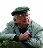
The most influential of all such writers was Alfred Wainwright
Alfred Wainwright
Alfred Wainwright MBE was a British fellwalker, guidebook author and illustrator. His seven-volume Pictorial Guide to the Lakeland Fells, published between 1955 and 1966 and consisting entirely of reproductions of his manuscript, has become the standard reference work to 214 of the fells of the...
whose Pictorial Guide to the Lakeland Fells
Pictorial Guide to the Lakeland Fells
A Pictorial Guide to the Lakeland Fells is a series of seven books by A. Wainwright, detailing the fells of the Lake District in northwest England...
series has sold in excess of 2 million copies, being in print continuously since the first volume was published in 1952. Wainwright divided the fells into seven geographical areas, each surrounded by valleys and low passes. While any such division must be arbitrary and later writers have deviated to a greater or lesser extent from this blueprint,
the sevenfold division remains the best known partitioning of the fells into 'sub ranges', each with its own characteristics. The Eastern Fells are one of these divisions, covered by volume 1 of Wainwright's work..
Boundaries and Principal Sub-Groups
The Eastern Fells occupy the region between the A591 KeswickKeswick, Cumbria
Keswick is a market town and civil parish within the Borough of Allerdale in Cumbria, England. It had a population of 4,984, according to the 2001 census, and is situated just north of Derwent Water, and a short distance from Bassenthwaite Lake, both in the Lake District National Park...
to Ambleside
Ambleside
Ambleside is a town in Cumbria, in North West England.Historically within the county of Westmorland, it is situated at the head of Windermere, England's largest lake...
road and the lake of Ullswater
Ullswater
Ullswater is the second largest lake in the English Lake District, being approximately nine miles long and 0.75 miles wide with a maximum depth of slightly more than ....
to the west. The Helvellyn range
Helvellyn range
Helvellyn range is the name given to a part of the Eastern Fells in the English Lake District, fell being the local word for hill. The name comes from Helvellyn, the highest point of the group....
forms the main spine of the group, running on a north south axis and remaining above 2,000 ft throughout its length. To the south of the Helvellyn range, across the depression of Grisedale Hause, is the Fairfield group of fells. There are also a number of subsidiary ridges and outliers, particularly to the east of the main range. The eastern fells constitute the largest, if not necessarily the wildest, area of high ground within the district, its long sweeping ridges the perfect environment for long distance walking.
Topography
Great Mell Fell
Great Mell Fell is a hill in the Eastern Fells of the English Lake District. It is a north-eastern outlier of the Helvellyn range, but, like its twin Little Mell Fell, is isolated from its fellows, standing in the middle of a flat plain...
and Little Mell Fell
Little Mell Fell
Little Mell Fell is a fell in the English Lake District. It is an outlier of the Eastern Fells, standing to the north of Ullswater. Two miles to the north west is Great Mell Fell, often thought of as its 'twin'.-Topography:...
are rounded "pudding basins", the first stirrings of Lakeland on the approach from Penrith
Penrith, Cumbria
Penrith was an urban district between 1894 and 1974, when it was merged into Eden District.The authority's area was coterminous with the civil parish of Penrith although when the council was abolished Penrith became an unparished area....
, while Gowbarrow Fell
Gowbarrow Fell
Gowbarrow Fell is a fell in the English Lake District. It is an outlier of the Eastern Fells, standing to the north of Ullswater and above the famous Aira Force waterfall.-Topography:...
shows the initial outcropping of rock.
The Helvellyn range proper begins in the north at Clough Head
Clough Head
Clough Head is a fell in the English Lake District. It is the northernmost top of the Helvellyn range in the Eastern Fells, standing to the south of Threlkeld and the A66.-Topography:...
, which reverses the character of the rest of these fells by bearing its crags to the west and its long smooth slopes to the east. South from here are The Dodds, three fells clad in grass almost throughout. Great Dodd
Great Dodd
Great Dodd is a fell in the English Lake District. It stands on the main spine of the Helvellyn range in the Eastern Fells, between the Vale of St John and Dockray.-Topography:...
and Stybarrow Dodd
Stybarrow Dodd
Stybarrow Dodd is a fell in the English Lake District. It stands on the main spine of the Helvellyn range in the Eastern Fells, situated between Thirlmere and the Ullswater catchment.-Topography:...
throw out long ridges to the east, enclosing the marshy valley of Deepdale. Between the two is Watson's Dodd
Watson's Dodd
Watson's Dodd is a fell in the English Lake District. It forms part of the Helvellyn range in the Eastern Fells. This chain of hills runs north-south and, in the vicinity of Watson's Dodd, forms the watershed between the Thirlmere and Ullswater catchments....
, a ridge top with considerably less prominence. The range now drops to a low point at Sticks Pass, a bridleway linking the settlements around Thirlmere
Thirlmere
Thirlmere is a reservoir in the Borough of Allerdale in Cumbria and the English Lake District. It runs roughly south to north, with a dam at the northern end, and is bordered on the eastern side by the A591 road and on the western side by a minor road....
and Ullswater. This is the only point on the main ridge below 2,500 ft.
South of the Sticks, the western slopes continue round and anodyne while the eastern flanks become craggier with every passing mile. Raise and White Side
White Side
White Side is a fell in the English Lake District. It is situated to the east of Thirlmere and to the west of Glenridding valley. This places White Side in the Helvellyn range of the Eastern Fells, with Raise to the north and Helvellyn Lower Man to the south, both of which are of greater...
are followed by the highest of the eastern fells, Helvellyn
Helvellyn
Helvellyn is a mountain in the English Lake District, the apex of the Eastern Fells. At above sea level, it is the third highest peak in both the Lake District and England...
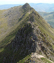
. East from its summit plateau run the twin arête
Arete
Areté is the term meaning "virtue" or "excellence", from Greek ἈρετήArete may also be used:*as a given name of persons or things:**Queen Arete , a character in Homer's Odyssey.***197 Arete, an asteroid....
s of Striding and Swirral Edges, the former easily the most famous ridge walk in Lakeland. The long valleys of Glenridding
Glenridding
Glenridding is a village located at the southern end of Ullswater, in the English Lake District. The village is popular with mountain walkers who can scale England's third highest mountain, Helvellyn, and many other challenging peaks from here. The village has ample accommodation including two...
and Grisedale cut deep into the range from the shores of Ullswater, providing access to this walkers’ wonderland. The final tops of the Helvellyn range are Nethermost Pike
Nethermost Pike
Nethermost Pike is a fell in Cumbria, England, and a part of the Lake District. At it is the second highest Wainwright in the Helvellyn range, the tallest of which is Helvellyn itself. It is located close to the southern end of the ridge, with Helvellyn to the north, and High Crag and Dollywaggon...
and Dollywaggon Pike
Dollywaggon Pike
Dollywaggon Pike is a fell in the English Lake District. It stands on the main spine of the Helvellyn range in the Eastern Fells, between Thirlmere and the Ullswater catchment.-Name:...
, both displaying shattered faces above Grisedale of which there is no hint in views from the west.

Seat Sandal
Seat Sandal is a fell in the English Lake District, it is situated four kilometers north of the village of Grasmere from where it is very well seen...
the watershed continues south east over Fairfield
Fairfield (Lake District)
Fairfield is a fell in the English Lake District. It is the highest of a group of hills in the Eastern Fells, standing to the south of the Helvellyn range.-Topography:...
, Hart Crag
Hart Crag
Hart Crag is a fell in the English Lake District, being one of the Fairfield group of hills in the Eastern Fells.-Topography:The fell stands on the ridge running south east from Fairfield to Dove Crag, at the point where a long subsidiary spur sweeps off to the north east...
and Dove Crag
Dove Crag
Dove Crag is a fell in the English Lake District. Situated in the Eastern Fells of the national park, seven kilometres south-south-west of Glenridding, it reaches a height of 792 metres...
to the col at Scandale Pass (a footpath). The pattern of the Helvellyns is repeated with walls of crag on the north east and grass on the opposing flanks. Long valleys now cut in from both sides with (another) Deepdale and Dovedale to the north and Rydale and Scandale to the south. If Striding Edge is the most popular ridge in the Lake District then the circuit of Rydale, commonly known as the Fairfield horseshoe
Fairfield horseshoe
Fairfield Horseshoe is a classic circular hillwalking ridge walk route starting from Rydal or Ambleside in the English Lake District that takes in all the fells that surround the valley of the Rydal Beck....
is the most popular circular ridgewalk. Beyond Scandale pass, standing aloof, but still considered a part of the Fairfield Group, is Red Screes
Red Screes
Red Screes is a fell in the English Lake District, situated between the villages of Patterdale and Ambleside. It is an outlier of the Fairfield group in the Eastern Fells, but is separated from its neighbours by low cols...
. This is
the final top before the ground drops down to the road over Kirkstone Pass
Kirkstone Pass
Kirkstone Pass is a mountain pass in the English Lake District, in the county of Cumbria. It is at an altitude of .This is the Lake District's highest pass that is open to motor traffic and it connects Ambleside in the Rothay Valley to Patterdale in the Ullswater Valley - the A592 road. In places,...
. Rising on the other side are the Far Eastern Fells
Far Eastern Fells
The Far Eastern Fells are a group of hills in the English Lake District. Reaching their highest point at High Street they occupy a broad area to the east of Ullswater and Kirkstone Pass. Much quieter than the central areas of Lakeland they offer in general easier but less exciting walking as the...
.
Access for Walkers
Ambleside provides a base at the south west corner of the range and there are numerous opportunities for car-parking (or more sustainable modes of transport) all along the A591. In the east, where the mountain scenery is so much more stirring to begin with, Patterdale provides the focal point. From here the long valleys of Grisedale and Glenridding can be used to gain access deep into the fells. Further south are the mouths of Deepdale and Dovedale, gateways to the rock scenery of the Fairfield Group. Mention should also be made of the Kirkstone Pass which provides a 1,500 ft headstart for climbs of Red Screes, together with a sales point for alcoholic beverages.See also
- Far Eastern FellsFar Eastern FellsThe Far Eastern Fells are a group of hills in the English Lake District. Reaching their highest point at High Street they occupy a broad area to the east of Ullswater and Kirkstone Pass. Much quieter than the central areas of Lakeland they offer in general easier but less exciting walking as the...
- Central FellsCentral FellsThe Central Fells are a group of hills in the English Lake District. Reaching their highest point at High Raise , they occupy a broad area to the east of Borrowdale. Perhaps unexpectedly the Central Fells are generally lower than the surrounding hills, the Lake District's general dome-like...
- Southern FellsSouthern FellsImage:Annotated Scafell range.jpg|thumb|300px|The Scafellsrect 23 372 252 419 Slight Side rect 173 794 560 834 Scafell East Buttressrect 707 787 893 861 Esk Pike or Crag rect 245 303 409 358 Sca Fell rect 408 238 637 280 Mickledore Image:Annotated Scafell range.jpg|thumb|300px|The Scafellsrect 23...
- Northern FellsNorthern FellsThe Northern Fells are a group of hills in the English Lake District. Including Skiddaw, they occupy a wide area to the north of Keswick. Smooth sweeping slopes predominate with a minimum of tarns or crags...
- North Western FellsNorth Western FellsThe North Western Fells are a group of hills in the English Lake District. Including such favourites as Catbells and Grisedale Pike, they occupy an oval area beneath the Buttermere and Borrowdale valley systems...
- Western FellsWestern FellsThe Western Fells are a group of hills in the English Lake District. Centred on Great Gable they occupy a triangular area between Buttermere and Wasdale...