
Old Man of Coniston
Encyclopedia
The Old Man of Coniston is a fell
in the Furness Fells
in the English
Lake District
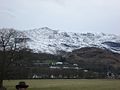
. It is 2634 feet (803 m) high, and lies to the west of the village of Coniston
and the lake of the same name, Coniston Water
. The fell is sometimes known by the alternate name of Coniston Old Man, or simply The Old Man. The mountain is a popular with tourists and fell-walkers with a number of well-marked paths to the summit. The mountain has also seen extensive slate mining activity for eight hundred years and the remains of abandoned mines and spoil tips are a significant feature of the north east slopes. There are also several flocks of sheep that are grazed on the mountain.
, though following the 1974 revision of county boundaries in England
it now lies, for administrative purposes, within Cumbria. This assertion rests upon its being higher than its near northern neighbour, Swirl How
. There appears to be some doubt
in the current literature over whether the height of Swirl How is 802 or 804 m, following resurveying. If modern measurement has not added 2 m to its rival then The Old Man of Coniston is the highest point in the Furness Fells
, and the twelfth most prominent
mountain in England
.
 The Coniston (or Furness) Fells form the watershed between Coniston Water in the east and the Duddon valley to the west. The range begins in the north at Wrynose Pass
and runs south for around 10 miles (16.1 km) before petering out at Broughton in Furness on the Duddon Estuary. Alfred Wainwright
in his influential Pictorial Guide to the Lakeland Fells
took only the northern half of the range as Lakeland proper, consigning the lower hills southward to a supplementary work The Outlying Fells of Lakeland. Later guidebook writers have chosen to include the whole range in their main volumes.
The central part of the Coniston range can be likened to an inverted 'Y' with Brim Fell
at the connecting point of the three arms. The main spine of the ridge runs north over Swirl How and Great Carrs
and south west to Dow Crag
and the lower hills beyond. The third arm is a truncated spur, running only half a mile to the summit of the Old Man before tumbling away south eastward to the valley floor. This ridge end position gives the fell a sense of isolation and increased stature, with steep faces on three sides.
To the west is the deep trench containing Goat’s Water. This elongated tarn
has a depth of about 50 ft (15.2 m). and contains trout
and char
. Enclosed by high ground, it has an outlet to the south through a field of boulders. This is one of the headwaters of Torver Beck, which passes a disused quarry near the Tranearth climbing hut, keeping the workings topped up via an artificial but extremely picturesque waterfall. The stream finally issues into Coniston Water to the south of Torver village.
The southern and eastern flanks of The Old Man are composed of rough ground, deeply pockmarked by slate quarries. One of these quarries, Bursting Stone, is still operating to produce an olive green slate. Across the southern slopes runs the Walna Scar
Road. This was the original trade route between Coniston village and the settlements of the Duddon Valley and is a public byway open to all traffic.
The first section rising steeply from Coniston is a metalled road, maintained partly to provide access to the quarry. This leads to a carpark at an altitude of 740 ft (225.6 m), a popular starting point for climbs. Beyond here motor vehicles are prohibited, but the track continues to its summit at 2000 ft (609.6 m), crossing the ridge to the south of Dow Crag.
Coniston Old Man has no connecting ridges other than that to Brim Fell, but a discernible rib falls due east via Stubthwaite Crag and Crowberry Haws. Below the tourist route path, this rib climbs again to The Bell, a fine rocky top (1,099 ft) with excellent views of the lake and village.
Nestling beneath the northern face of The Old Man, and cradled between it and Raven’s Tor, is Low Water. This fine corrie
tarn has been dammed in the past to provide water for the quarries, but all of its water now issues via a fine cascade of falls into the Coppermines Valley. This area, shared with the neighbouring fells of Brim Fell and Wetherlam
, is heavily scarred by historic copper
, nickel
and cobalt
mining, particularly in the latter half of the 19th century.
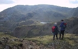
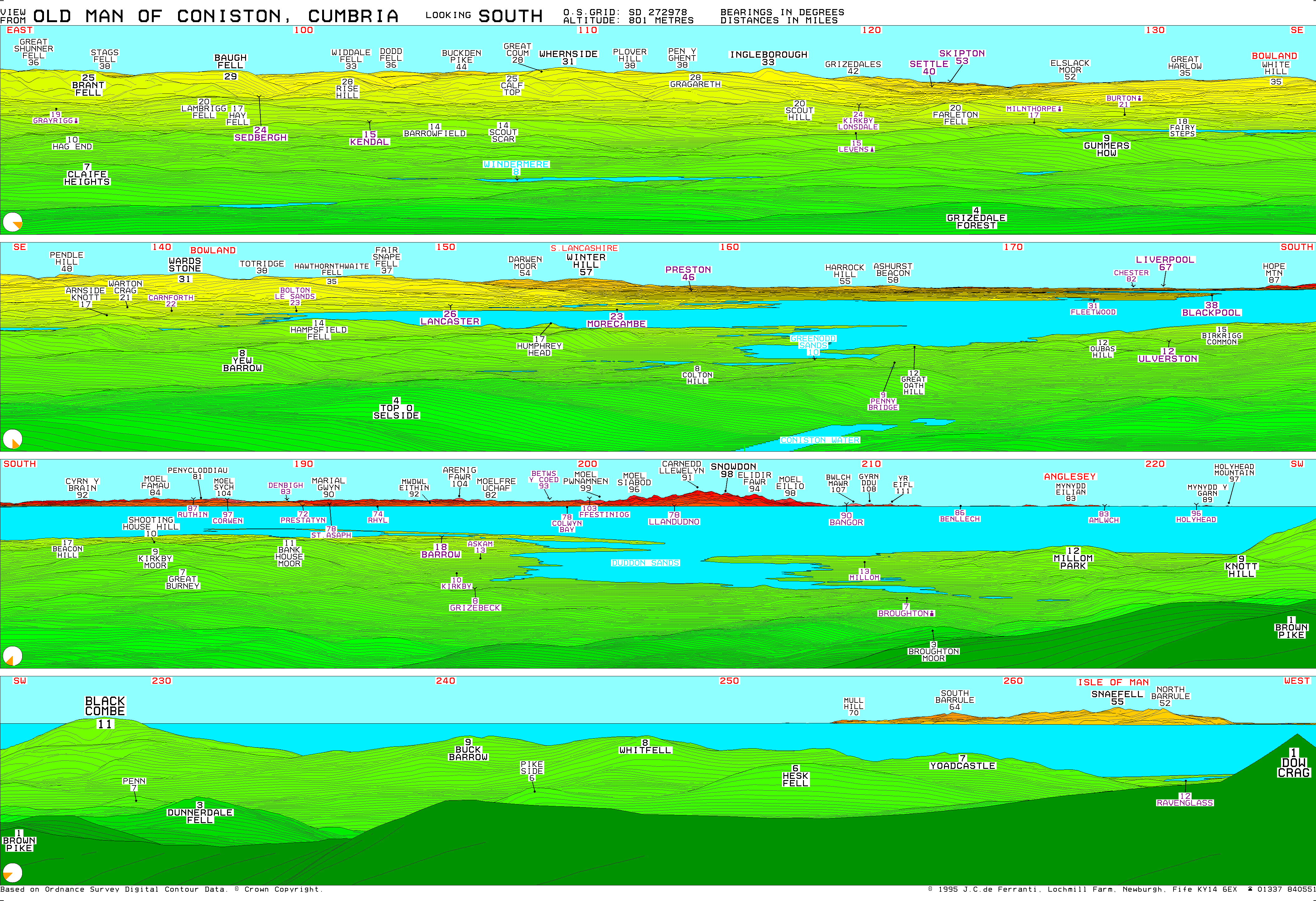
. The popularity of this climb has resulted in the resident sheep being quite tame, and they show no fear in rifling unwatched bags for food. The extensive view from the summit on a clear day includes much of the southern Lake District, Morecambe Bay
, Blackpool Tower
, Winter Hill
, the Lancashire coast and the Isle of Man
. Perhaps the highlight is the close up view of Dow Crag.
In 2006, London writer Kris Griffiths' attempt to climb The Old Man of Coniston for the first time almost ended fatally after getting trapped in the dark on his descent
The nearby slate mines on the North East flank of the Old Man, are known as "Old Man Quarries", though sometimes given the individual names of: Brandy Crag, SaddleStone and Moss Head. These slate mines have been worked since at least the 13th century. All the workings are more or less underground, apart from Low Brandy Crag, which was opened out into an opencast quarry in the 1980s by Burlington Stone, and is still operating today. Most of the lower levels in Saddlestone are blocked, though the Moss Head Quarries are still open.
lapilli
-tuff
s of the Lag Bank Formation crosses the summit. The southern slopes show the volcaniclastic sandstone
s of the Seathwaite Fell Formation, while the rhyolitic
tuffs of the Paddy End Member stretch from north of the summit toward the Coppermines.
's Swallows and Amazons climb in the Swallows and Amazons novel Swallowdale
.
Fell
“Fell” is a word used to refer to mountains, or certain types of mountainous landscape, in Scandinavia, the Isle of Man, and parts of northern England.- Etymology :...
in the Furness Fells
Furness Fells
The Furness Fells are those hills and mountains in the Furness region of Cumbria, England. Historically part of Lancashire, the Furness Fells or High Furness is the name given to the upland part of Furness, that is, that part of Furness lying north of the line between Ulverston and Ireleth...
in the English
England
England is a country that is part of the United Kingdom. It shares land borders with Scotland to the north and Wales to the west; the Irish Sea is to the north west, the Celtic Sea to the south west, with the North Sea to the east and the English Channel to the south separating it from continental...
Lake District
Lake District
The Lake District, also commonly known as The Lakes or Lakeland, is a mountainous region in North West England. A popular holiday destination, it is famous not only for its lakes and its mountains but also for its associations with the early 19th century poetry and writings of William Wordsworth...
. It is 2634 feet (803 m) high, and lies to the west of the village of Coniston
Coniston, Cumbria
Coniston is a village and civil parish in the Furness region of Cumbria, England. It is located in the southern part of the Lake District National Park, between Coniston Water, the third longest lake in the Lake District, and Coniston Old Man; about north east of Barrow-in-Furness.-Geography and...
and the lake of the same name, Coniston Water
Coniston Water
Coniston Water in Cumbria, England is the third largest lake in the English Lake District. It is five miles long, half a mile wide, has a maximum depth of 184 feet , and covers an area of . The lake has an elevation of 143 feet above sea level...
. The fell is sometimes known by the alternate name of Coniston Old Man, or simply The Old Man. The mountain is a popular with tourists and fell-walkers with a number of well-marked paths to the summit. The mountain has also seen extensive slate mining activity for eight hundred years and the remains of abandoned mines and spoil tips are a significant feature of the north east slopes. There are also several flocks of sheep that are grazed on the mountain.
Highest Fell in the Range?
The Old Man is the highest point in historical LancashireLancashire
Lancashire is a non-metropolitan county of historic origin in the North West of England. It takes its name from the city of Lancaster, and is sometimes known as the County of Lancaster. Although Lancaster is still considered to be the county town, Lancashire County Council is based in Preston...
, though following the 1974 revision of county boundaries in England
England
England is a country that is part of the United Kingdom. It shares land borders with Scotland to the north and Wales to the west; the Irish Sea is to the north west, the Celtic Sea to the south west, with the North Sea to the east and the English Channel to the south separating it from continental...
it now lies, for administrative purposes, within Cumbria. This assertion rests upon its being higher than its near northern neighbour, Swirl How
Swirl How
Swirl How is a fell in the English Lake District. It stands between Coniston and the Duddon Valley in the southern part of the District.The Coniston Fells form the watershed between Coniston Water and the Duddon valley to the west. The range begins at Wrynose Pass and runs south for around...
. There appears to be some doubt
Swirl How
Swirl How is a fell in the English Lake District. It stands between Coniston and the Duddon Valley in the southern part of the District.The Coniston Fells form the watershed between Coniston Water and the Duddon valley to the west. The range begins at Wrynose Pass and runs south for around...
in the current literature over whether the height of Swirl How is 802 or 804 m, following resurveying. If modern measurement has not added 2 m to its rival then The Old Man of Coniston is the highest point in the Furness Fells
Furness Fells
The Furness Fells are those hills and mountains in the Furness region of Cumbria, England. Historically part of Lancashire, the Furness Fells or High Furness is the name given to the upland part of Furness, that is, that part of Furness lying north of the line between Ulverston and Ireleth...
, and the twelfth most prominent
Topographic prominence
In topography, prominence, also known as autonomous height, relative height, shoulder drop , or prime factor , categorizes the height of the mountain's or hill's summit by the elevation between it and the lowest contour line encircling it and no higher summit...
mountain in England
England
England is a country that is part of the United Kingdom. It shares land borders with Scotland to the north and Wales to the west; the Irish Sea is to the north west, the Celtic Sea to the south west, with the North Sea to the east and the English Channel to the south separating it from continental...
.
Topography
Wrynose Pass
The Wrynose Pass is a mountain pass in the Lake District National Park in Cumbria, England between the Duddon Valley and Little Langdale.-Road:...
and runs south for around 10 miles (16.1 km) before petering out at Broughton in Furness on the Duddon Estuary. Alfred Wainwright
Alfred Wainwright
Alfred Wainwright MBE was a British fellwalker, guidebook author and illustrator. His seven-volume Pictorial Guide to the Lakeland Fells, published between 1955 and 1966 and consisting entirely of reproductions of his manuscript, has become the standard reference work to 214 of the fells of the...
in his influential Pictorial Guide to the Lakeland Fells
Pictorial Guide to the Lakeland Fells
A Pictorial Guide to the Lakeland Fells is a series of seven books by A. Wainwright, detailing the fells of the Lake District in northwest England...
took only the northern half of the range as Lakeland proper, consigning the lower hills southward to a supplementary work The Outlying Fells of Lakeland. Later guidebook writers have chosen to include the whole range in their main volumes.
The central part of the Coniston range can be likened to an inverted 'Y' with Brim Fell
Brim Fell
Brim Fell is a fell in the English Lake District. It stands to the west of Coniston village in the southern part of the District.-Topography:The Coniston Fells form the watershed between Coniston Water and the Duddon valley to the west...
at the connecting point of the three arms. The main spine of the ridge runs north over Swirl How and Great Carrs
Great Carrs
Great Carrs is a fell in the English Lake District. It stands above Wrynose Pass in the southern part of the District.-Topography:The Coniston Fells form the watershed between Coniston Water and the Duddon valley to the west. The range begins at Wrynose Pass and runs south for around 10 miles...
and south west to Dow Crag
Dow Crag
Dow Crag is a fell in the English Lake District near Coniston, Cumbria. The eastern face is one of the many rock faces in the Lake District used for rock climbing....
and the lower hills beyond. The third arm is a truncated spur, running only half a mile to the summit of the Old Man before tumbling away south eastward to the valley floor. This ridge end position gives the fell a sense of isolation and increased stature, with steep faces on three sides.
To the west is the deep trench containing Goat’s Water. This elongated tarn
Tarn (lake)
A tarn is a mountain lake or pool, formed in a cirque excavated by a glacier. A moraine may form a natural dam below a tarn. A corrie may be called a cirque.The word is derived from the Old Norse word tjörn meaning pond...
has a depth of about 50 ft (15.2 m). and contains trout
Trout
Trout is the name for a number of species of freshwater and saltwater fish belonging to the Salmoninae subfamily of the family Salmonidae. Salmon belong to the same family as trout. Most salmon species spend almost all their lives in salt water...
and char
Salvelinus
Salvelinus is a genus of salmonid fish often called char or charr; some species are called "trout". Salvelinus is a member of the Salmoninae subfamily of the Salmonidae family. Charr may be identified by light cream pink or red spots over a darker body. Scales tend to be small, with 115-200 along...
. Enclosed by high ground, it has an outlet to the south through a field of boulders. This is one of the headwaters of Torver Beck, which passes a disused quarry near the Tranearth climbing hut, keeping the workings topped up via an artificial but extremely picturesque waterfall. The stream finally issues into Coniston Water to the south of Torver village.
The southern and eastern flanks of The Old Man are composed of rough ground, deeply pockmarked by slate quarries. One of these quarries, Bursting Stone, is still operating to produce an olive green slate. Across the southern slopes runs the Walna Scar
Walna Scar
Walna Scar is a hill in the English Lake District, lying just south of a pass of the same name in the Coniston Hills. Its summit is only slightly higher than the pass, but few reach it, preferring instead to head north from the top of the pass to Dow Crag and the other Coniston Fells...
Road. This was the original trade route between Coniston village and the settlements of the Duddon Valley and is a public byway open to all traffic.
The first section rising steeply from Coniston is a metalled road, maintained partly to provide access to the quarry. This leads to a carpark at an altitude of 740 ft (225.6 m), a popular starting point for climbs. Beyond here motor vehicles are prohibited, but the track continues to its summit at 2000 ft (609.6 m), crossing the ridge to the south of Dow Crag.
Coniston Old Man has no connecting ridges other than that to Brim Fell, but a discernible rib falls due east via Stubthwaite Crag and Crowberry Haws. Below the tourist route path, this rib climbs again to The Bell, a fine rocky top (1,099 ft) with excellent views of the lake and village.
Nestling beneath the northern face of The Old Man, and cradled between it and Raven’s Tor, is Low Water. This fine corrie
Cirque
Cirque may refer to:* Cirque, a geological formation* Makhtesh, an erosional landform found in the Negev desert of Israel and Sinai of Egypt*Cirque , an album by Biosphere* Cirque Corporation, a company that makes touchpads...
tarn has been dammed in the past to provide water for the quarries, but all of its water now issues via a fine cascade of falls into the Coppermines Valley. This area, shared with the neighbouring fells of Brim Fell and Wetherlam
Wetherlam
Wetherlam is a mountain in the English Lake District. It is the most northerly of the Coniston Fells, the range of fells to the north-west of Coniston village; its north-east slopes descend to Little Langdale.-Topography:...
, is heavily scarred by historic copper
Copper
Copper is a chemical element with the symbol Cu and atomic number 29. It is a ductile metal with very high thermal and electrical conductivity. Pure copper is soft and malleable; an exposed surface has a reddish-orange tarnish...
, nickel
Nickel
Nickel is a chemical element with the chemical symbol Ni and atomic number 28. It is a silvery-white lustrous metal with a slight golden tinge. Nickel belongs to the transition metals and is hard and ductile...
and cobalt
Cobalt
Cobalt is a chemical element with symbol Co and atomic number 27. It is found naturally only in chemically combined form. The free element, produced by reductive smelting, is a hard, lustrous, silver-gray metal....
mining, particularly in the latter half of the 19th century.
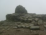
Summit and view
The summit of the fell carries a unique construction, a combined slate platform and cairnCairn
Cairn is a term used mainly in the English-speaking world for a man-made pile of stones. It comes from the or . Cairns are found all over the world in uplands, on moorland, on mountaintops, near waterways and on sea cliffs, and also in barren desert and tundra areas...
. The popularity of this climb has resulted in the resident sheep being quite tame, and they show no fear in rifling unwatched bags for food. The extensive view from the summit on a clear day includes much of the southern Lake District, Morecambe Bay
Morecambe Bay
Morecambe Bay is a large bay in northwest England, nearly due east of the Isle of Man and just to the south of the Lake District National Park. It is the largest expanse of intertidal mudflats and sand in the United Kingdom, covering a total area of 310 km².-Natural features:The rivers Leven,...
, Blackpool Tower
Blackpool Tower
Blackpool Tower Eye is a tourist attraction in Blackpool, Lancashire in England which was opened to the public on 14 May 1894. . Inspired by the Eiffel Tower in Paris, it rises to 518 feet & 9 inches . The tower is a member of the World Federation of Great Towers...
, Winter Hill
Winter Hill (Lancashire)
Winter Hill is a hill on the border of the boroughs of Chorley, Blackburn with Darwen and Bolton, in North West England. It is located on Rivington Moor, Chorley and is high...
, the Lancashire coast and the Isle of Man
Isle of Man
The Isle of Man , otherwise known simply as Mann , is a self-governing British Crown Dependency, located in the Irish Sea between the islands of Great Britain and Ireland, within the British Isles. The head of state is Queen Elizabeth II, who holds the title of Lord of Mann. The Lord of Mann is...
. Perhaps the highlight is the close up view of Dow Crag.
Ascents
The fell is normally climbed from Coniston village via Church Beck and the mines (the tourist route). Alternatives include the south ridge and the path to Goat’s Water, both ascending from the Walna Scar Road. The carpark at the top of the metalled section provides a headstart for these routes. The Walna Scar Road can also be reached from Torver, or from Seathwaite in the Duddon Valley, although the latter results in an indirect climb via Dow Crag.In 2006, London writer Kris Griffiths' attempt to climb The Old Man of Coniston for the first time almost ended fatally after getting trapped in the dark on his descent
Slate & Copper Mining
Coniston has been Lakeland's centre for slate and copper mining for 500 years. The well known ‘Coniston copper mines’ are reputed to be some of the largest copper mines in Britain, with a vertical distance of around 2000 ft (609.6 m).The nearby slate mines on the North East flank of the Old Man, are known as "Old Man Quarries", though sometimes given the individual names of: Brandy Crag, SaddleStone and Moss Head. These slate mines have been worked since at least the 13th century. All the workings are more or less underground, apart from Low Brandy Crag, which was opened out into an opencast quarry in the 1980s by Burlington Stone, and is still operating today. Most of the lower levels in Saddlestone are blocked, though the Moss Head Quarries are still open.
Geology
A band of the daciticDacite
Dacite is an igneous, volcanic rock. It has an aphanitic to porphyritic texture and is intermediate in composition between andesite and rhyolite. The relative proportions of feldspars and quartz in dacite, and in many other volcanic rocks, are illustrated in the QAPF diagram...
lapilli
Lapilli
Lapilli is a size classification term for tephra, which is material that falls out of the air during a volcanic eruption or during some meteorite impacts. Lapilli means "little stones" in Latin. They are in some senses similar to ooids or pisoids in calcareous sediments.By definition lapilli range...
-tuff
Tuff
Tuff is a type of rock consisting of consolidated volcanic ash ejected from vents during a volcanic eruption. Tuff is sometimes called tufa, particularly when used as construction material, although tufa also refers to a quite different rock. Rock that contains greater than 50% tuff is considered...
s of the Lag Bank Formation crosses the summit. The southern slopes show the volcaniclastic sandstone
Sandstone
Sandstone is a sedimentary rock composed mainly of sand-sized minerals or rock grains.Most sandstone is composed of quartz and/or feldspar because these are the most common minerals in the Earth's crust. Like sand, sandstone may be any colour, but the most common colours are tan, brown, yellow,...
s of the Seathwaite Fell Formation, while the rhyolitic
Rhyolite
This page is about a volcanic rock. For the ghost town see Rhyolite, Nevada, and for the satellite system, see Rhyolite/Aquacade.Rhyolite is an igneous, volcanic rock, of felsic composition . It may have any texture from glassy to aphanitic to porphyritic...
tuffs of the Paddy End Member stretch from north of the summit toward the Coppermines.
Influence
The Old Man of Coniston is the inspiration for Kanchenjunga, the mountain Arthur RansomeArthur Ransome
Arthur Michell Ransome was an English author and journalist, best known for writing the Swallows and Amazons series of children's books. These tell of school-holiday adventures of children, mostly in the Lake District and the Norfolk Broads. Many of the books involve sailing; other common subjects...
's Swallows and Amazons climb in the Swallows and Amazons novel Swallowdale
Swallowdale
Swallowdale is the second book in the Swallows and Amazons series by Arthur Ransome. It was published in 1931. In this book, camping in the hills and moorland country around Ransome's Lake in the North features much more prominently and there is less sailing...
.
External links
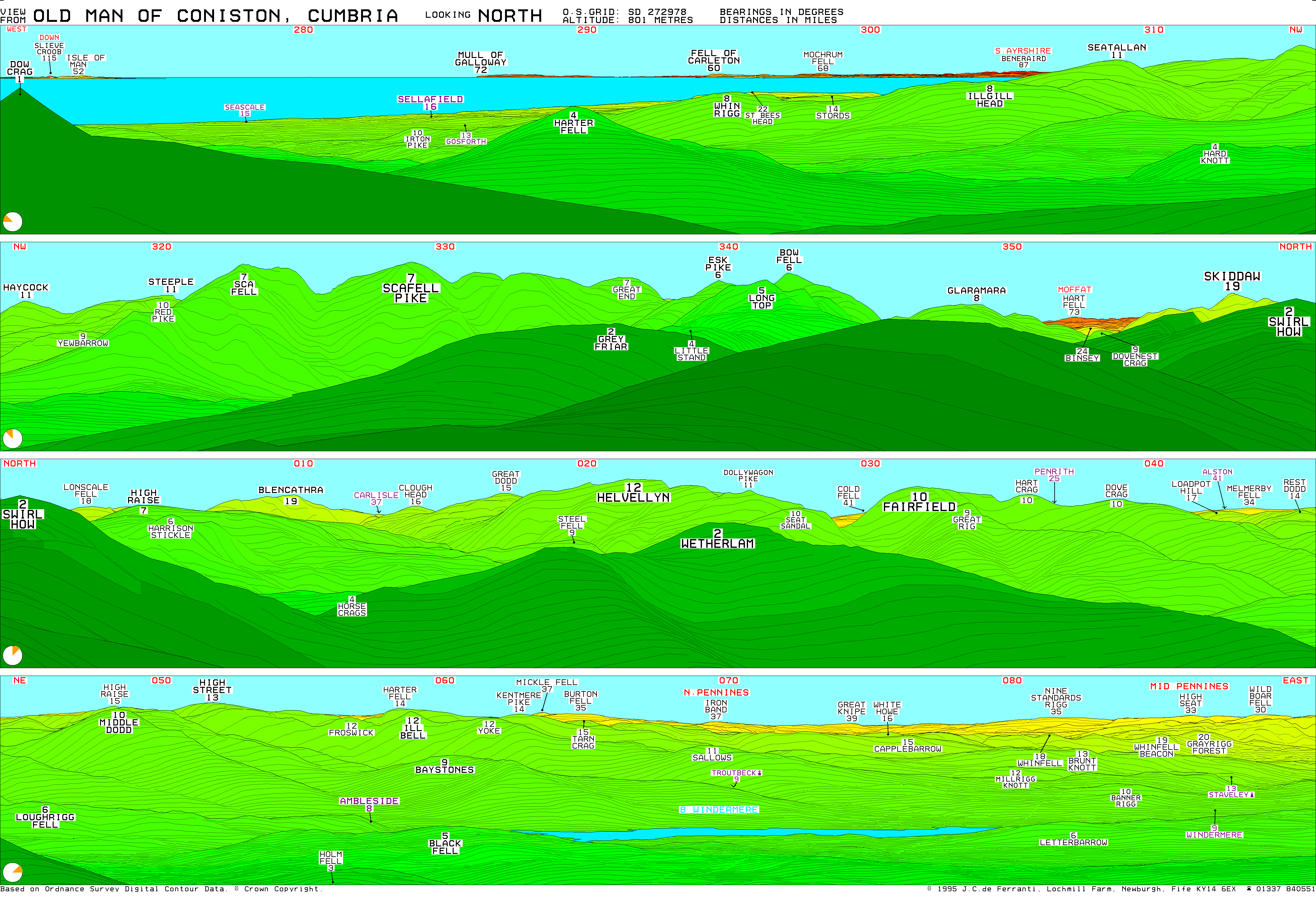
- Computer generated summit panoramas North South Index
- Lake District Walks - Old Man Of Coniston Walk