

Southern Fells
Encyclopedia
Image:Annotated Scafell range.jpg|thumb|300px|The Scafells
rect 23 372 252 419 Slight Side (762 m)
Slight Side
Slight Side is a fell in the English Lake District it stands 25 kilometers east southeast of the town of Whitehaven and reaches a height of 762 m . Slight Side lies at the south western edge of the Scafell Massif, a four kilometre long crescent of high ground which includes the highest ground...
rect 173 794 560 834 Scafell East Buttress
Sca Fell
Sca Fell is a mountain in the English Lake District. Its height of 964 metres makes it the second-highest mountain in England after Scafell Pike, from which it is separated by the col of Mickledore....
rect 707 787 893 861 Esk Pike or Crag (885 m)
Esk Pike
Esk Pike is a fell in the English Lake District, one of the great cirque of hills forming the head of Eskdale.-Topography:The Southern Fells include the highest ground in England, a horseshoe which begins with Scafell and Scafell Pike in the west and then curves around the north of Upper Eskdale to...
rect 245 303 409 358 Sca Fell (964 m)
Sca Fell
Sca Fell is a mountain in the English Lake District. Its height of 964 metres makes it the second-highest mountain in England after Scafell Pike, from which it is separated by the col of Mickledore....
rect 408 238 637 280 Mickledore (c. 840 m)
Mickledore
Mickledore is a narrow ridge, 840 metres high, connecting the mountains of Sca Fell and Scafell Pike in the English Lake District. It is also a pass between the valleys of Wasdale and Eskdale....
rect 544 174 826 213 South Summit (<978 m)
Scafell Pike
Scafell Pike is the highest mountain in England at . It is located in Lake District National Park sometimes confused with the neighbouring Sca Fell, to which it is connected by the col of Mickledore...
rect 706 310 928 355 Scafell Pike (978 m)
Scafell Pike
Scafell Pike is the highest mountain in England at . It is located in Lake District National Park sometimes confused with the neighbouring Sca Fell, to which it is connected by the col of Mickledore...
rect 870 238 1108 286 Broad Crag (934 m)
Broad Crag
Broad Crag is a fell in the English Lake District. By some counts, it is the fifth highest peak in England at a height of 934 metres .-Topography:It forms part of the Scafell chain, and lies about northeast of Scafell Pike...
rect 1043 308 1198 360 Ill Crag (935 m)
Ill Crag
Ill Crag is a fell in the English Lake District. By some counts it is the fourth highest peak in England, although many people, including Alfred Wainwright, consider it to be a subsidiary summit of Scafell Pike...
rect 1238 311 1446 351 Great End (910 m)
Great End
Great End is the most northerly mountain in the Scafell chain, in the English Lake District. From the south it is simply a lump continuing this chain....
rect 0 0 1444 1085 Click hyperlink or button to expand
desc none
The Southern Fells are a group of hills in the English
England
England is a country that is part of the United Kingdom. It shares land borders with Scotland to the north and Wales to the west; the Irish Sea is to the north west, the Celtic Sea to the south west, with the North Sea to the east and the English Channel to the south separating it from continental...
Lake District
Lake District
The Lake District, also commonly known as The Lakes or Lakeland, is a mountainous region in North West England. A popular holiday destination, it is famous not only for its lakes and its mountains but also for its associations with the early 19th century poetry and writings of William Wordsworth...
. Including Scafell Pike
Scafell Pike
Scafell Pike is the highest mountain in England at . It is located in Lake District National Park sometimes confused with the neighbouring Sca Fell, to which it is connected by the col of Mickledore...
, the highest peak in England, they occupy a broad area to the south of Great Langdale
Great Langdale
Great Langdale is a valley in the Lake District National Park in the county of Cumbria, in the northwest of England. It is often simply referred to as Langdale, the epithet Great distinguishing it from the neighbouring valley of Little Langdale....
, Borrowdale
Borrowdale
Borrowdale is a valley and civil parish in the English Lake District in the Borough of Allerdale in Cumbria, England.Borrowdale lies within the historic county boundaries of Cumberland, and is sometimes referred to as Cumberland Borrowdale in order to distinguish it from another Borrowdale in the...
and Wasdale
Wasdale
Wasdale is a valley and civil parish in the western part of the Lake District National Park in Cumbria, England. The River Irt flows through the valley to its estuary at Ravenglass. A large part of the main valley floor is occupied by Wastwater, the deepest lake in England...
. High and rocky towards the centre of the Lake District, the Southern Fells progressively take on a moorland character toward the south west. In the south east are the well known Furness Fells
Furness Fells
The Furness Fells are those hills and mountains in the Furness region of Cumbria, England. Historically part of Lancashire, the Furness Fells or High Furness is the name given to the upland part of Furness, that is, that part of Furness lying north of the line between Ulverston and Ireleth...
, their heavily quarried flanks rising above Coniston Water
Coniston Water
Coniston Water in Cumbria, England is the third largest lake in the English Lake District. It is five miles long, half a mile wide, has a maximum depth of 184 feet , and covers an area of . The lake has an elevation of 143 feet above sea level...
.
Partition of the Lakeland Fells

National park
A national park is a reserve of natural, semi-natural, or developed land that a sovereign state declares or owns. Although individual nations designate their own national parks differently A national park is a reserve of natural, semi-natural, or developed land that a sovereign state declares or...
in the north west of the country which, in addition to its lake
Lake
A lake is a body of relatively still fresh or salt water of considerable size, localized in a basin, that is surrounded by land. Lakes are inland and not part of the ocean and therefore are distinct from lagoons, and are larger and deeper than ponds. Lakes can be contrasted with rivers or streams,...
s, contains a complex range of hills. These are known locally as fells and range from low hills to the highest ground in England. Hundreds of tops exist and many writers have attempted to draw up definitive lists
Hill lists in the British Isles
The mountains and hills of Great Britain, and to a lesser extent Ireland, are the subject of a considerable number of lists that categorise them by height, topographic prominence, or other criteria. They are commonly used as a basis for peak bagging, whereby hillwalkers attempt to reach all the...
. In doing so the compilers frequently divide the range into smaller areas to aid their description.
The most influential of all such authors was Alfred Wainwright
Alfred Wainwright
Alfred Wainwright MBE was a British fellwalker, guidebook author and illustrator. His seven-volume Pictorial Guide to the Lakeland Fells, published between 1955 and 1966 and consisting entirely of reproductions of his manuscript, has become the standard reference work to 214 of the fells of the...
whose Pictorial Guide to the Lakeland Fells
Pictorial Guide to the Lakeland Fells
A Pictorial Guide to the Lakeland Fells is a series of seven books by A. Wainwright, detailing the fells of the Lake District in northwest England...
series has sold in excess of 2 million copies, being in print continuously since the first volume was published in 1952. Wainwright divided the fells into seven geographical areas, each surrounded by valleys and low passes. While any such division must be arbitrary- and later writers have deviated to a greater or lesser extent from this blueprint- Wainwright's sevenfold division remains the best known partitioning of the fells into 'sub ranges', each with its own characteristics. The Southern Fells are one of these divisions, covered by volume 4 of Wainwright's work.
Boundaries
Of all Wainwright's boundary decisions, the outer perimeter of the Southern Fells is the most often debated. Two ridges continue south west on either side of the Duddon Valley, the longer ending only at the Irish Sea in the terminal height of Black CombeBlack Combe
Black Combe is a fell in the south-west corner of the Lake District National Park, just four miles from the Irish Sea. It lies near the west coast of Cumbria in the borough of Copeland and more specifically, an area known as South Copeland...
. Wainwright however chose to excise a wide area of fell from his guidebooks, declaring that "south and west from Green Crag
Green Crag
Green Crag is a fell in the English Lake District. It stands between Eskdale and the Duddon valley in the Southern Fells.-Topography:The headwaters of Eskdale and the Duddon are separated by a ridge falling south west from the summit of Crinkle Crags. This line of high ground continues over many...
the scenery quickly deteriorates. This summit has therefore been taken as the boundary of fellwalking country for the purposes of this book and the territory southwest omitted from the map". He makes similar statements regarding the fells to the south of Dow Crag
Dow Crag
Dow Crag is a fell in the English Lake District near Coniston, Cumbria. The eastern face is one of the many rock faces in the Lake District used for rock climbing....
on the parallel Coniston ridge. The later Fellranger guides mirror part of Wainwright's Southern Fells in the curiously named "Mid-Western Fells" volume, and then all of the fells south from Wrynose
Wrynose Pass
The Wrynose Pass is a mountain pass in the Lake District National Park in Cumbria, England between the Duddon Valley and Little Langdale.-Road:...
and Hardknott Pass
Hardknott Pass
Hardknott Pass is a pass that carries a minor road between Eskdale and the Duddon Valley in the region of Cumbria, England, in the Lake District National Park...
es to the sea in a further volume, "The Southern Fells". The author, Mark Richards, notes his differences with Wainwright in the introduction. Birkett simply includes everything without comment. Even Wainwright ultimately relented and included the southern extremities in an eighth guidebook, "The Outlying fells of Lakeland" (1974).
The northern boundaries are clear, beginning on the west with Wastwater and rising up beyond the head of Wasdale to Sty Head Pass, the popular walkers' route to Borrowdale. Across the border on this side are Great Gable
Great Gable
Great Gable is a mountain lying at the very heart of the English Lake District, appearing as a pyramid from Wasdale , but as a dome from most other directions. It is one of the most popular of the Lakeland fells, and there are many different routes to the summit...
and the Western Fells
Western Fells
The Western Fells are a group of hills in the English Lake District. Centred on Great Gable they occupy a triangular area between Buttermere and Wasdale...
. The boundary continues north to Stonethwaite in Borrowdale, before turning sharply south east along the Langstrath branch of that valley, including the long ridge of Glaramara
Glaramara
Glaramara is a fell in the English Lake District in Cumbria. It is a substantial fell that is part of a long ridge that stretches for over six kilometres from Stonethwaite in Borrowdale up to the important mountain pass of Esk Hause...
within the Southern Fells. At the head of Langstrath the perimeter crosses Stake Pass, another pedestrian route, and sweeps eastward down Great Langdale to Windermere. Stake Pass provides the high level link to the Langdale Pikes in the Central Fells
Central Fells
The Central Fells are a group of hills in the English Lake District. Reaching their highest point at High Raise , they occupy a broad area to the east of Borrowdale. Perhaps unexpectedly the Central Fells are generally lower than the surrounding hills, the Lake District's general dome-like...
. Although falling within the Southern Fells area, Wainwright makes no mention of the low hills between Coniston and Windermere in the Pictorial Guides. These appear, somewhat illogically, within his Outlying Fells volume.
Topography
The Southern Fells occupy a broad sector of the circular Lake District massif, trending a little to the west of centre and about 10 miles (16 km) across in either direction. In addition to the perimeter dales, EskdaleEskdale, Cumbria
Eskdale is a glacial valley and civil parish in the western Lake District National Park in Cumbria, England. It forms part of the Borough of Copeland, and has a population of 264....
and the Duddon Valley
Duddon Valley
The Duddon Valley is a valley in the Lake District National Park in Cumbria, England. The River Duddon flows through the valley, rising in the mountains between Eskdale and Langdale, before flowing into the Irish Sea near Broughton in Furness...
provide further subdivision flowing out from the centre of the district.
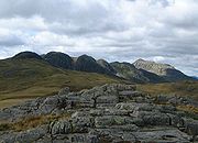
Scafells
Image:Annotated Scafell range.jpg|thumb|right|300px|The Scafell range as seen looking west from Crinkle Crags. rect 23 372 252 419 Slight Side rect 173 794 560 834 Scafell East Buttress...
. Also standing above the valleys of Wasdale, Borrowdale and Great Langdale, this high cirque is open to the south and contains England's highest ground. The range begins on the west with Slight Side
Slight Side
Slight Side is a fell in the English Lake District it stands 25 kilometers east southeast of the town of Whitehaven and reaches a height of 762 m . Slight Side lies at the south western edge of the Scafell Massif, a four kilometre long crescent of high ground which includes the highest ground...
before rising to the summits of Scafell, Scafell Pike
Scafell Pike
Scafell Pike is the highest mountain in England at . It is located in Lake District National Park sometimes confused with the neighbouring Sca Fell, to which it is connected by the col of Mickledore...
and Great End
Great End
Great End is the most northerly mountain in the Scafell chain, in the English Lake District. From the south it is simply a lump continuing this chain....
. Across the gap of Esk Hause and enclosing the eastern side of Eskdale are Esk Pike
Esk Pike
Esk Pike is a fell in the English Lake District, one of the great cirque of hills forming the head of Eskdale.-Topography:The Southern Fells include the highest ground in England, a horseshoe which begins with Scafell and Scafell Pike in the west and then curves around the north of Upper Eskdale to...
, Bowfell
Bowfell
Bowfell is a pyramid-shaped mountain lying at the heart of the English Lake District, in the Southern Fells area. It is the sixth highest mountain in the lakes and one of the most popular of the Lake District fells...
and Crinkle Crags
Crinkle Crags
Crinkle Crags is a fell in the English Lake District in the county of Cumbria. It forms part of two major rings of mountains, surrounding the valleys of Great Langdale and Upper Eskdale. The name reflects the fell's physical appearance as its summit ridge is a series of five rises and depressions ...
. Satellites to this main ridge are Lingmell
Lingmell
Lingmell is a fell in the English Lake District, standing above the village of Wasdale Head. It is an outlier on the north-west flank of Scafell Pike, England's highest mountain.-Topography:...
above Wasdale and the Allen Crags
Allen Crags
Allen Crags is a fell in the English Lake District, it lies in a group of very popular hills and is regarded as part of the Scafell group of fells...
- Glaramara
Glaramara
Glaramara is a fell in the English Lake District in Cumbria. It is a substantial fell that is part of a long ridge that stretches for over six kilometres from Stonethwaite in Borrowdale up to the important mountain pass of Esk Hause...
- Rosthwaite Fell
Rosthwaite Fell
Rosthwaite Fell is a fell in the English Lake District. It is situated some due south of Keswick and south of the village of Rosthwaite in Borrowdale.Rosthwaite Fell also has loose connections to the Scafell group of fells...
ridge jutting deep into Borrowdale. East of Bowfell is Rossett Pike
Rossett Pike
Rossett Pike is a fell in the English Lake District. It is located at the head of Mickleden, one of two tributary valleys of Great Langdale.-Topography:...
providing the link to the Central Fells. More loosely connected are Illgill Head
Illgill Head
Illgill Head is a fell in the English Lake District. It is known more commonly as the northern portion of the Wastwater Screes. The fell is 609 metres high and stands along the south-east shore of Wast Water, the deepest lake in England.-Topography:...
and Whin Rigg
Whin Rigg
Whin Rigg is a fell is the English Lake District, situated in the western segment of the national park, 22 kilometres south east of the town of Whitehaven...
, the fells forming the famous Wastwater Screes.
South from Crinkle Crags, between Eskdale and the Duddon, are Hard Knott
Hard Knott
Hard Knott is a hill in the English Lake District, at the head of Eskdale.-Topography:The headwaters of the River Esk and the Duddon are separated by a ridge falling south west from the summit of Crinkle Crags. This line of high ground continues over many twists and turns for , finally meeting the...
, Harter Fell
Harter Fell (Eskdale)
Harter Fell is a mountain in the western part of the English Lake District located between the Eskdale and Duddon valleys. Its height is 649 m . There are several walking routes to the summit.-Topography:...
and Green Crag
Green Crag
Green Crag is a fell in the English Lake District. It stands between Eskdale and the Duddon valley in the Southern Fells.-Topography:The headwaters of Eskdale and the Duddon are separated by a ridge falling south west from the summit of Crinkle Crags. This line of high ground continues over many...
. A second ridge falls south easterly from Crinkles over Cold Pike
Cold Pike
Cold Pike is a fell in the English Lake District. It is a satellite of Crinkle Crags and stands above the Upper Duddon Valley.-Topography:...
and Pike O'Blisco, crosses the motor road of Wrynose Pass
Wrynose Pass
The Wrynose Pass is a mountain pass in the Lake District National Park in Cumbria, England between the Duddon Valley and Little Langdale.-Road:...
and then rises to Great Carrs
Great Carrs
Great Carrs is a fell in the English Lake District. It stands above Wrynose Pass in the southern part of the District.-Topography:The Coniston Fells form the watershed between Coniston Water and the Duddon valley to the west. The range begins at Wrynose Pass and runs south for around 10 miles...
, the first of the Coniston (or Furness) Fells. The remainder of this group comprises Swirl How
Swirl How
Swirl How is a fell in the English Lake District. It stands between Coniston and the Duddon Valley in the southern part of the District.The Coniston Fells form the watershed between Coniston Water and the Duddon valley to the west. The range begins at Wrynose Pass and runs south for around...
, Grey Friar
Grey Friar
Grey Friar is a fell in the English Lake District, it is one of the Coniston Fells and is situated 13 kilometres west-south-west of Ambleside. It reaches a height of 770 metres and stands to the north west of the other Coniston Fells, a little off the beaten track and tends to be the least visited...
, Wetherlam
Wetherlam
Wetherlam is a mountain in the English Lake District. It is the most northerly of the Coniston Fells, the range of fells to the north-west of Coniston village; its north-east slopes descend to Little Langdale.-Topography:...
, Brim Fell
Brim Fell
Brim Fell is a fell in the English Lake District. It stands to the west of Coniston village in the southern part of the District.-Topography:The Coniston Fells form the watershed between Coniston Water and the Duddon valley to the west...
, Coniston Old Man and Dow Crag
Dow Crag
Dow Crag is a fell in the English Lake District near Coniston, Cumbria. The eastern face is one of the many rock faces in the Lake District used for rock climbing....
, together forming the watershed between Coniston and the Duddon. To the east are the low outliers of Holme Fell
Holme Fell
Holme Fell or Holm Fell is a fell in the Lake District in Cumbria, England. It is located between Coniston Water and Little Langdale, almost isolated from the neighbouring Coniston Fells by Yewdale Beck.-Topography:...
and Black Fell
Black Fell (Lake District)
Black Fell is a fell in the English Lake District. It rises to the north of Tarn Hows, between Coniston and Hawkshead.-Topography:Black Fell is the high point in the hilly area bounded by Windermere, Langdale and Coniston. It occupies an area of around one mile by two, clad mainly in fell grass...
.
Access for walkers
The high Southern Fells can be accessed from many of the principal walking centres of Lakeland, namely the heads of Wasdale, Borrowdale, Langdale and Eskdale. Sty Head, the Stake, Rossett Gill, Grains Gill, Burnmoor Tarn and Esk Hause provide pedestrian links between all of these valleys, many miles apart by road.The main paths from Seathwaite or Wasdale Head to Scafell Pike, and from Great Langdale up Bowfell are heavily used, as is the 'Tourist Route' up Coniston Old Man. These tops will be busy on almost any day of the year. Away from these famous tops however it is possible to find quieter walking, particularly to the south.
See also
- Eastern FellsEastern FellsThe Eastern Fells are a group of hills in the English Lake District. Centred on Helvellyn they primarily comprise a north south ridge running between Ullswater and Lakeland's Central Valley.-Partition of the Lakeland Fells:...
- Far Eastern FellsFar Eastern FellsThe Far Eastern Fells are a group of hills in the English Lake District. Reaching their highest point at High Street they occupy a broad area to the east of Ullswater and Kirkstone Pass. Much quieter than the central areas of Lakeland they offer in general easier but less exciting walking as the...
- Central FellsCentral FellsThe Central Fells are a group of hills in the English Lake District. Reaching their highest point at High Raise , they occupy a broad area to the east of Borrowdale. Perhaps unexpectedly the Central Fells are generally lower than the surrounding hills, the Lake District's general dome-like...
- Northern FellsNorthern FellsThe Northern Fells are a group of hills in the English Lake District. Including Skiddaw, they occupy a wide area to the north of Keswick. Smooth sweeping slopes predominate with a minimum of tarns or crags...
- North Western FellsNorth Western FellsThe North Western Fells are a group of hills in the English Lake District. Including such favourites as Catbells and Grisedale Pike, they occupy an oval area beneath the Buttermere and Borrowdale valley systems...
- Western FellsWestern FellsThe Western Fells are a group of hills in the English Lake District. Centred on Great Gable they occupy a triangular area between Buttermere and Wasdale...