

Rakata
Encyclopedia
Stratovolcano
A stratovolcano, also known as a composite volcano, is a tall, conical volcano built up by many layers of hardened lava, tephra, pumice, and volcanic ash. Unlike shield volcanoes, stratovolcanoes are characterized by a steep profile and periodic, explosive eruptions...
of the Indonesia
Indonesia
Indonesia , officially the Republic of Indonesia , is a country in Southeast Asia and Oceania. Indonesia is an archipelago comprising approximately 13,000 islands. It has 33 provinces with over 238 million people, and is the world's fourth most populous country. Indonesia is a republic, with an...
n island
Island
An island or isle is any piece of sub-continental land that is surrounded by water. Very small islands such as emergent land features on atolls can be called islets, cays or keys. An island in a river or lake may be called an eyot , or holm...
of Krakatoa
Krakatoa
Krakatoa is a volcanic island made of a'a lava in the Sunda Strait between the islands of Java and Sumatra in Indonesia. The name is used for the island group, the main island , and the volcano as a whole. The island exploded in 1883, killing approximately 40,000 people, although some estimates...
in the Sunda Strait
Sunda Strait
The Sunda Strait is the strait between the Indonesian islands of Java and Sumatra. It connects the Java Sea to the Indian Ocean...
between the islands of Sumatra
Sumatra
Sumatra is an island in western Indonesia, westernmost of the Sunda Islands. It is the largest island entirely in Indonesia , and the sixth largest island in the world at 473,481 km2 with a population of 50,365,538...
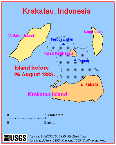
and Java. Standing 813 metres (2,667.3 ft) tall, it was the largest and southernmost of three volcanoes that formed the island Krakatoa (the others being Danan
Danan
Danan was one of the three volcanic cones on the island of Krakatoa, in the Sunda Strait, in Indonesia. It stood , laid in the central area of the island, and may have been a twin volcano...
and Perboewatan
Perboewatan
Perboewatan was one of the three main volcanic cones on the island of Krakatoa , in the Sunda Strait, in Indonesia. It was the lowest and northernmost of the cones...
) and the only one not totally destroyed in the eruption of 1883
1883 eruption of Krakatoa
The 1883 eruption of Krakatoa began in May 1883 and culminated with the destruction of Krakatoa on 27 August 1883. Minor seismic activity continued to be reported until February 1884, though reports after October 1883 were later dismissed by Rogier Verbeek's investigation.-Early phase:In the years...
. Rakata did lose its northern half in that eruption, leaving just its southern half. The exposed cliff is quite striking visually, partially of a large exposed dike
Dike (geology)
A dike or dyke in geology is a type of sheet intrusion referring to any geologic body that cuts discordantly across* planar wall rock structures, such as bedding or foliation...
terminating in a large lenticular extrusion at the middle of the almost vertical cliff. The feature has been called "the Eye of Krakatoa."
Etymology
Because the words Rakata and Krakatau are the same in Indonesian, both names are used interchangeably, leading to confusion in languages which distinguish between the two words. In geological usage, Krakatau is the island and Rakata is the main volcanic cone on that island. But Krakatau is also used for the volcanic edifice as a whole, including all four islands (Krakatau, Anak Krakatau, VerlatenVerlaten
Verlaten Island is an island in the Sunda Strait in Indonesia, between Java and Sumatra. It is one of the Krakatoa Islands, near the famous volcano. Other than some minor collapse in the southeast , Verlaten suffered little damage in the 1883 eruption...
and Lang
Lang Island
Lang Island lies in the Sunda Strait, between Java and Sumatra, in Indonesia. It is one of the Krakatoa Islands, near the famous volcano...
). Before 1883 (and in many of the eruption reports), Rakata was just referred to as "the Peak (of Krakatau)."
Physical features
Rakata is a volcanic coneVolcanic cone
Volcanic cones are among the simplest volcanic formations. They are built by ejecta from a volcanic vent, piling up around the vent in the shape of a cone with a central crater. Volcanic cones are of different types, depending upon the nature and size of the fragments ejected during the eruption...
with its northern face being a vertical cliff
Cliff
In geography and geology, a cliff is a significant vertical, or near vertical, rock exposure. Cliffs are formed as erosion landforms due to the processes of erosion and weathering that produce them. Cliffs are common on coasts, in mountainous areas, escarpments and along rivers. Cliffs are usually...
, exposing much of its eruptive history. More than 25 extrusion dikes have been counted; the largest at the center runs from sea level to 320 meters above and terminates in a large (about 6 meters in diameter), convex form. It is not known if the two are actually related in origin or just coincidental.
The 1883 eruption
Rakata seems to have played a comparatively minor role in the 1883 eruption of Krakatoa1883 eruption of Krakatoa
The 1883 eruption of Krakatoa began in May 1883 and culminated with the destruction of Krakatoa on 27 August 1883. Minor seismic activity continued to be reported until February 1884, though reports after October 1883 were later dismissed by Rogier Verbeek's investigation.-Early phase:In the years...
. Some reports seem to indicate it started erupting ("venting") in late July, compared to Perboewatan starting in May and Danan in June. (Furneaux mentions an unsourced report that the Peak had collapsed sometime in July.) However, it is more proper to realize that all of the eruptive centers of Krakatau have a common source and that we are talking about particular cones of the same volcano, rather than separate volcanoes. The map made by Capt. Ferzaneer from his visit on August 11 shows no eruptive "foci" from Rakata or its slopes (although there are several from the southern part of Danan), but he was not able to investigate the southern or western parts of the island due to the ash cloud blowing in that direction.
In his portrayal of the catastrophe, Rogier Verbeek
Rogier Verbeek
Rogier Diederik Marius Verbeek was a Dutch geologist and nature scientist.His journal Krakatau, which was edited in 1884 and 1885 by order of the Governor-General of the Dutch East Indies, is his most known work. It deals with the eruption of the volcanic island Krakatoa in 1883 and brought...
depicts that Rakata's northern half was destroyed, along with the central part of the island, during the largest explosion, which occurred at 10:02 am on August 27. Verbeek surmised that unlike Danan and Perboewatan, Rakata was not directly above the magma chamber
Magma chamber
A magma chamber is a large underground pool of molten rock found beneath the surface of the Earth. The molten rock in such a chamber is under great pressure, and given enough time, that pressure can gradually fracture the rock around it creating outlets for the magma...
, being connected only by a fissure which lay along the cleavage line of the caldera
Caldera
A caldera is a cauldron-like volcanic feature usually formed by the collapse of land following a volcanic eruption, such as the one at Yellowstone National Park in the US. They are sometimes confused with volcanic craters...
. However, examining the cliff from the air indicates two arcs, the second of which seems to be due to later (post-1883) landslides of unstable cliff material.
In surveys made a few months after the catastrophe, Rakata's height is given as 830 m, compared to 820 m before, however this may be due to inaccuracy of the earlier surveys. Verbeek reports that the cleavage was approximately at the old summit. The remnant of Rakata grew rather considerably in area due to falling pumice. However, most of the increased area (largely to the west and southeast) was washed away within several years by wave action.
Due to the severity of the eruption, leaving very little flora and fauna alive, Rakata has been used as a modern study on biological island colonization.
Recent activity
There are no dated reports of eruptions from Rakata since the 1883 catastrophe1883 eruption of Krakatoa
The 1883 eruption of Krakatoa began in May 1883 and culminated with the destruction of Krakatoa on 27 August 1883. Minor seismic activity continued to be reported until February 1884, though reports after October 1883 were later dismissed by Rogier Verbeek's investigation.-Early phase:In the years...
, although tentative datings have been made from dating ash deposits left.
Subsequent activity of Krakatoa
Krakatoa
Krakatoa is a volcanic island made of a'a lava in the Sunda Strait between the islands of Java and Sumatra in Indonesia. The name is used for the island group, the main island , and the volcano as a whole. The island exploded in 1883, killing approximately 40,000 people, although some estimates...
seems to be limited to the area that had been between Danan
Danan
Danan was one of the three volcanic cones on the island of Krakatoa, in the Sunda Strait, in Indonesia. It stood , laid in the central area of the island, and may have been a twin volcano...
and Perboewatan
Perboewatan
Perboewatan was one of the three main volcanic cones on the island of Krakatoa , in the Sunda Strait, in Indonesia. It was the lowest and northernmost of the cones...
, where Anak Krakatoa has arisen, starting in 1927. Rakata cone itself would seem to be extinct since its conduit
Magma
Magma is a mixture of molten rock, volatiles and solids that is found beneath the surface of the Earth, and is expected to exist on other terrestrial planets. Besides molten rock, magma may also contain suspended crystals and dissolved gas and sometimes also gas bubbles. Magma often collects in...
has been virtually destroyed.