
Rabbit Island, New Zealand
Encyclopedia
Rabbit Island is the name of several different islands off the New Zealand
coast.
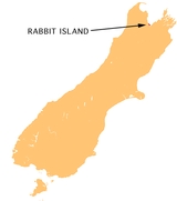
The largest and best-known Rabbit Island lies across the southernmost part of Tasman Bay
, at the top of New Zealand's South Island
. The long narrow island runs east-west for 8 kilometres (5 mi), and covers
15 km² (5.8 sq mi).
It lies opposite the mouth of the Waimea River, 7 kilometres (4.3 mi) to the west of Richmond
.
The island is a popular beach resort to the residents of Motueka
, Wakefield
, Brightwater
, Richmond, Mapua
, Stoke
and Nelson
itself. A medium-sized bridge spans a tidal area and joins the mainland to Rabbit Island itself. There is a large grassed area after this bridge and a Fire Hazard sign ("Keep it Green"). After this, the beach proper begins. Vast and mountainous sand dunes topped with masses of cone-bearing pines, with exposed roots, can be seen extending for impressive distances along the island.
New Zealand
New Zealand is an island country in the south-western Pacific Ocean comprising two main landmasses and numerous smaller islands. The country is situated some east of Australia across the Tasman Sea, and roughly south of the Pacific island nations of New Caledonia, Fiji, and Tonga...
coast.
The largest and best-known Rabbit Island lies across the southernmost part of Tasman Bay
Tasman Bay
Tasman Bay is a large V-shaped bay at the north end of New Zealand's South Island. Located in the centre of the island's northern coast, it stretches along of coastline and is across at its widest point. It is an arm of the Tasman Sea, lying on the western approach to Cook Strait.At the bay's...
, at the top of New Zealand's South Island
South Island
The South Island is the larger of the two major islands of New Zealand, the other being the more populous North Island. It is bordered to the north by Cook Strait, to the west by the Tasman Sea, to the south and east by the Pacific Ocean...
. The long narrow island runs east-west for 8 kilometres (5 mi), and covers
15 km² (5.8 sq mi).
It lies opposite the mouth of the Waimea River, 7 kilometres (4.3 mi) to the west of Richmond
Richmond, New Zealand
Richmond, the seat of the Tasman District Council, lies 13 km south of Nelson in the South Island of New Zealand, close to the southern extremity of Tasman Bay...
.
The island is a popular beach resort to the residents of Motueka
Motueka
The town of Motueka in the South Island of New Zealand lies close to the mouth of the Motueka River, on the western shore of Tasman Bay. It is, after Nelson and Richmond, the third largest centre in the Tasman Region, with a population of 7125...
, Wakefield
Wakefield, New Zealand
The small New Zealand community of Wakefield is situated some 25 km south west of Nelson at the top of the South Island.First settled in about 1843, it was originally called Pitfure. However the name was soon changed to Wakefield...
, Brightwater
Brightwater
Brightwater is a town 20 kilometres southwest of Nelson in Tasman district in the South Island of New Zealand. It stands on the banks of the Wairoa River. Brightwater was named by Alfred Saunders, the owner of a local Flax mill situated on the banks of the Wairoa River, after a popular song at the...
, Richmond, Mapua
Mapua, New Zealand
Mapua is a small town in the South Island of New Zealand.It is to the west of Nelson on State Highway 60 and on the coastline of Tasman Bay. The 2006 census gave a population of 1878, up 16.1 percent since the 2001 Census.:...
, Stoke
Stoke, New Zealand
Stoke is one of the suburbs of Nelson, New Zealand. It lies between Richmond and Tahunanui. Stoke has a population of around 7000. Stoke was voted 'Keep New Zealand Beautiful Peoples Choice Best Place in New Zealand' in 2010.-Main attractions:...
and Nelson
Nelson, New Zealand
Nelson is a city on the eastern shores of Tasman Bay, and is the economic and cultural centre of the Nelson-Tasman region. Established in 1841, it is the second oldest settled city in New Zealand and the oldest in the South Island....
itself. A medium-sized bridge spans a tidal area and joins the mainland to Rabbit Island itself. There is a large grassed area after this bridge and a Fire Hazard sign ("Keep it Green"). After this, the beach proper begins. Vast and mountainous sand dunes topped with masses of cone-bearing pines, with exposed roots, can be seen extending for impressive distances along the island.
Others islands with the same name
The other Rabbit Islands are smaller than 1 km² (0.386102158592535 sq mi) or 100 ha (247.1 acre). They are located (north to south):- inside WhangareiWhangareiWhangarei, pronounced , is the northernmost city in New Zealand and the regional capital of Northland Region. Although commonly classified as a city, it is officially part of the Whangarei District, administered by the Whangarei District Council a local body created in 1989 to administer both the...
Habour, Northland Region 35.7888°N 174.3475°W - just west of Great Barrier IslandGreat Barrier IslandGreat Barrier Island is a large island of New Zealand, situated to the north-east of central Auckland in the outer Hauraki Gulf. With an area of it is the fourth-largest island of New Zealand's main chain of islands, with its highest point, Mount Hobson, rising...
, Hauraki GulfHauraki GulfThe Hauraki Gulf is a coastal feature of the North Island of New Zealand. It has a total area of 4000 km², and lies between the Auckland Region, the Hauraki Plains, the Coromandel Peninsula and Great Barrier Island...
36.1477°N 175.3140°W - to the west of Kawau Island, north of AucklandAucklandThe Auckland metropolitan area , in the North Island of New Zealand, is the largest and most populous urban area in the country with residents, percent of the country's population. Auckland also has the largest Polynesian population of any city in the world...
36.4146°N 174.7932°W - off the east coast of the Coromandel PeninsulaCoromandel PeninsulaThe Coromandel Peninsula lies in the North Island of New Zealand. It is part of the Waikato Region and Thames-Coromandel District and extends 85 kilometres north from the western end of the Bay of Plenty, forming a natural barrier to protect the Hauraki Gulf and the Firth of Thames in the west...
, in Opito Bay 36.7137°N 175.8177°W - off the east coast of the Coromandel PeninsulaCoromandel PeninsulaThe Coromandel Peninsula lies in the North Island of New Zealand. It is part of the Waikato Region and Thames-Coromandel District and extends 85 kilometres north from the western end of the Bay of Plenty, forming a natural barrier to protect the Hauraki Gulf and the Firth of Thames in the west...
, near Slipper IslandSlipper IslandSlipper Island or is located to the east of the Coromandel Peninsula in New Zealand's North Island and southeast of the town of Pauanui. It is a beach resort privately owned by Nora & Abe Needham's 14 children, making it one of the few privately owned islands in New Zealand...
37.0713°N 175.9272°W - officially known as Motuotau Island, north of TaurangaTaurangaTauranga is the most populous city in the Bay of Plenty region, in the North Island of New Zealand.It was settled by Europeans in the early 19th century and was constituted as a city in 1963...
, off the beach east of Mount MaunganuiMount MaunganuiMount Maunganui is a town in the Bay of Plenty, New Zealand, located on a peninsula to the north of Tauranga. It was independent from Tauranga until the completion of the Tauranga Harbour Bridge in 1988....
37.6311°N 176.1940°W - inside the entrance to Blueskin BayBlueskin BayBlueskin Bay is an estuary in coastal Otago, about 25 km north of Dunedin.The name also unofficially describes the rural district which includes the northern slopes of Mount Cargill, the southern slopes of the Kilmog, and the townships of Doctors Point, Waitati, Evansdale, Warrington, and...
, north of Dunedin 45.7311°N 170.5907°W - south of RivertonRiverton, New ZealandRiverton or Aparima is a small town at the south of the South Island of New Zealand. It is in the Southland region and lies at the western end of Oreti Beach, 30 kilometres west of Invercargill on the Southern Scenic Route. It is approx. 45 km from Stewart Island and provides a safe harbour...
, in Foveaux StraitFoveaux StraitFoveaux Strait separates Stewart Island/Rakiura, New Zealand's third largest island, from the South Island. Three large bays, Te Waewae Bay, Oreti Beach and Toetoes Bay, sweep along the strait's northern coast, which also hosts Bluff township and harbour. Across the strait lie the Solander... - near the centre of BluffBluff, New ZealandBluff is a town and seaport in the Southland region, on the southern coast of the South Island of New Zealand. It is the southern-most town in New Zealand and, despite Slope Point being further to the south, is colloquially used to refer to the southern extremity of the country...
Harbour, Southland RegionSouthland RegionSouthland is New Zealand's southernmost region and is also a district within that region. It consists mainly of the southwestern portion of the South Island and Stewart Island / Rakiura...
46.5680°N 168.3305°W