

Public transport in Christchurch
Encyclopedia
Public transport
in Christchurch
, New Zealand consists of bus
services operated by three bus companies (who win a renewable tender process) supported by a ferry, all jointly marketed as Metro.
'Real-time' bus arrival times are displayed on electronic displays at bus stops, online and mobile (cellphone) WAP.
Ticketing and fares are, with some exceptions, standard across the city's network. An electronic 'Metro' card provides a discount off regular fares. Students receive a discount, and senior citizens travel free (a law from New Zealand's central government).
The 'Bus Exchange' in the city centre serves as the chief bus interchange point and passenger hub for the Metro network. The Exchange has attracted interest from other worldwide city authorities investigating how to improve their bus services. Since the Bus Exchange opened in 2000, the number of people using the bus service has doubled and numbers are still increasing. There is now a need to provide a larger Transport Interchange.
The City Council has purchased land for a new Transport Interchange in the block bounded by Colombo
, Lichfield, Durham and Tuam Streets. The new facility will be able to accommodate more buses. It is expected to have 26 bus stands rather than the nine in the current exchange. It will be safer because people will not need to walk across where buses enter and exit. Manoeuvring of buses will take place underground and there will be a below ground central waiting lounge for travellers. The interchange will integrate with other modes of transport such as cycling, taxis, long distance coaches and shuttles, car parking and in the future, light rail. As a result of the September 2010 and February 2011 earthquakes the Council has deferred some capital projects, including the new bus exchange, to focus resources on more urgent priorities. The current bus exchange building has been condemned and a temporary exchange is currently under construction at the site acquired for the new exchange.
Bus lanes operational during peak commuting hours have now opened on some routes. These were opened because traffic congestion was causing delays to services and discouraging commuters from using buses as an alternative to private motor vehicles. The routes have been controversial with some business owners concerned at the loss of parking from outide their businesses during the lanes operational times, but the lanes have improved bus travel times, schedule adherence and have resulted in an increase in passenger numbers. More bus lanes are proposed on other busy routes.
In early 2010 the Christchurch City Council published "A City for People Action Plan" based a 2009 study by Jan Gehl
, renown urban designer and city planner, with his recommendations into improving life in the city. The chief recommendation was to improve facilities for pedestrians and cyclists. As part of this the number of bus routes travelling down the city's main street, Colombo Street
, would be reduced. The majority of buses would travel an inner city ring route instead.
The following services are operated under the Metro brand.
Key Route operated by Red Bus Route operated by Leopard Coachlines
Route operated by Go Bus Christchurch
service in the inner city. The hybrid
buses, which are battery powered using a small Liquefied petroleum gas-fuelled gas turbine
engine to keep the battery charged, produce less air pollution
than normal diesel
buses. The Shuttle's fleet of (yellow) hybrid buses is operated by Red Bus Ltd
and the service is funded by Christchurch City Council.
is served by buses and shuttle vans
.
to Diamond Harbour
, a settlement on the opposite side of Lyttelton Harbour
. Ferries first began crossing Lyttelton Harbour in 1888. The ferry is operated by Black Cat Ltd.
 Christchurch Tramway Ltd
http://www.tram.co.nz/ operates a one-way tram
circuit of the central city. This is mainly marketed as a tourist attraction, but is available to local commuters with an annual season ticket
. Trams were originally introduced to Christchurch in 1905, ceased operating in 1954, and returned to the newly-built inner city loop in 1995, mainly as a tourist attraction.
Preliminary investigation into light rail options for Christchurch have begun. Investigating options and protecting possible routes is an action point in the City Council's "A City for People Action Plan" (approved in 2010). The new Transport Interchange is being designed to accommodate a future light rail network.
) has been scaled back to just TranzCoastal and TranzAlpine
, which leave from an architecturally controversial station in Riccarton.
by Environment Canterbury.
Christchurch City Council provides roading infrastructure and street furniture such as signs and seats and regulates parking at bus stop
s, and is also owner of Red Bus Ltd through its holding company Christchurch City Holdings
. The city council also fully funds the zero-fare The Shuttle service. The city council provided the current central city Bus Exchange in November 2000.
Vehicle safety standards are regulated by the New Zealand Transport Agency
.
", in which the author toured the city on public buses and compiled the stories of the people he met.
Public transport
Public transport is a shared passenger transportation service which is available for use by the general public, as distinct from modes such as taxicab, car pooling or hired buses which are not shared by strangers without private arrangement.Public transport modes include buses, trolleybuses, trams...
in Christchurch
Christchurch
Christchurch is the largest city in the South Island of New Zealand, and the country's second-largest urban area after Auckland. It lies one third of the way down the South Island's east coast, just north of Banks Peninsula which itself, since 2006, lies within the formal limits of...
, New Zealand consists of bus
Bus
A bus is a road vehicle designed to carry passengers. Buses can have a capacity as high as 300 passengers. The most common type of bus is the single-decker bus, with larger loads carried by double-decker buses and articulated buses, and smaller loads carried by midibuses and minibuses; coaches are...
services operated by three bus companies (who win a renewable tender process) supported by a ferry, all jointly marketed as Metro.
Overview
Buses from the three different companies in Christchurch display not only their own company logo and livery but also the Metro logo to signal they are part of the citywide network. The Northern Star service has its own blue livery. A Selwyn Star service will feature a yellow livery. The City Flyer buses are excused from having the logo as part of a commercial agreement.'Real-time' bus arrival times are displayed on electronic displays at bus stops, online and mobile (cellphone) WAP.
Ticketing and fares are, with some exceptions, standard across the city's network. An electronic 'Metro' card provides a discount off regular fares. Students receive a discount, and senior citizens travel free (a law from New Zealand's central government).
The 'Bus Exchange' in the city centre serves as the chief bus interchange point and passenger hub for the Metro network. The Exchange has attracted interest from other worldwide city authorities investigating how to improve their bus services. Since the Bus Exchange opened in 2000, the number of people using the bus service has doubled and numbers are still increasing. There is now a need to provide a larger Transport Interchange.
The City Council has purchased land for a new Transport Interchange in the block bounded by Colombo
Colombo Street
Colombo Street is a main road of the city of Christchurch, New Zealand. It runs south-north through the centre of Christchurch with a break at Cathedral Square. As with many other central Christchurch streets, it is named for a colonial Anglican bishopric, Colombo, in what at the time was known as...
, Lichfield, Durham and Tuam Streets. The new facility will be able to accommodate more buses. It is expected to have 26 bus stands rather than the nine in the current exchange. It will be safer because people will not need to walk across where buses enter and exit. Manoeuvring of buses will take place underground and there will be a below ground central waiting lounge for travellers. The interchange will integrate with other modes of transport such as cycling, taxis, long distance coaches and shuttles, car parking and in the future, light rail. As a result of the September 2010 and February 2011 earthquakes the Council has deferred some capital projects, including the new bus exchange, to focus resources on more urgent priorities. The current bus exchange building has been condemned and a temporary exchange is currently under construction at the site acquired for the new exchange.
Bus lanes operational during peak commuting hours have now opened on some routes. These were opened because traffic congestion was causing delays to services and discouraging commuters from using buses as an alternative to private motor vehicles. The routes have been controversial with some business owners concerned at the loss of parking from outide their businesses during the lanes operational times, but the lanes have improved bus travel times, schedule adherence and have resulted in an increase in passenger numbers. More bus lanes are proposed on other busy routes.
In early 2010 the Christchurch City Council published "A City for People Action Plan" based a 2009 study by Jan Gehl
Jan Gehl
Jan Gehl is a Danish architect and urban design consultant based in Copenhagen and whose career has focused on improving the quality of urban life by re-orienting city design towards the pedestrian and cyclist.-Biography:...
, renown urban designer and city planner, with his recommendations into improving life in the city. The chief recommendation was to improve facilities for pedestrians and cyclists. As part of this the number of bus routes travelling down the city's main street, Colombo Street
Colombo Street
Colombo Street is a main road of the city of Christchurch, New Zealand. It runs south-north through the centre of Christchurch with a break at Cathedral Square. As with many other central Christchurch streets, it is named for a colonial Anglican bishopric, Colombo, in what at the time was known as...
, would be reduced. The majority of buses would travel an inner city ring route instead.
Suburban bus services
The new Central Station replaced the two temporary bus exchanges which had replaced the city's damaged Bus Xchange. The new exchange is located between Lichfield Street and Tuam Street and will operate for up to two years. The Link Shuttle service which linked the two temporary exchanges has now been terminated.The following services are operated under the Metro brand.
| # | Route | Start | End | Timetable | Notes | ||
|---|---|---|---|---|---|---|---|
| C | Comet | Hornby Hornby, New Zealand Hornby is a major residential and retail suburb at the western edge of Christchurch, New Zealand.-Naming and history:Hornby was apparently named by Frederick William Delamain, who came to Christchurch from England in 1852. The name reportedly refers to Hornby-with-Farleton in Lancashire... |
via Airport Christchurch International Airport -Facts & figures:As the gateway for Christchurch and the South Island, Christchurch International Airport is New Zealand’s second largest airport.5,908,077 passengers travelled in and out of Christchurch International Airport from 1 July 2008 to 30 June 2009... |
Papanui Papanui Papanui is a major suburb of Christchurch New Zealand. It is sited five kilometers to the northwest of the city centre. Papanui is a middle socio-economic area with a population of 3,543 consisting predominantly of Pākehā 92.3%, Māori 5.7%, Pacific peoples 2.5%, Asian 5.0%, Middle Eastern/Latin... |
http://www.metroinfo.co.nz/timetables-maps/the-comet.html?route=c | ||
| M | Metrostar | Halswell Halswell Halswell is a satellite town of Christchurch, New Zealand, located in open country nine kilometres southwest of the city centre on State Highway 75... |
via Hornby | New Brighton New Brighton, New Zealand New Brighton is a coastal suburb of Christchurch, New Zealand, about to the east of the city centre.-Naming:The naming of New Brighton was apparently done on a 'spur of moment' decision by William Fee, an early settler of the area... |
http://www.metroinfo.co.nz/timetables-maps/metrostar.html?route=m | ||
| O | Orbiter | Circuit route through suburban shopping centres | http://www.metroinfo.co.nz/timetables-maps/orbiter.html?route=o | ||||
| 3 | Sumner to Airport | Sumner Sumner, New Zealand Sumner is a coastal seaside suburb of Christchurch, New Zealand and was surveyed and named in 1849 in honour of John Bird Sumner, the then newly appointed Archbishop of Canterbury and president of the Canterbury Association... |
via City & Avonhead Avonhead The suburb of Avonhead is located in the city of Christchurch. Avonhead has two primary schools The suburb of Avonhead is located in the city of Christchurch. Avonhead has two primary schools The suburb of Avonhead is located in the city of Christchurch. Avonhead has two primary schools (Avonhead... |
Airport | http://www.metroinfo.co.nz/timetables-maps/3-sumner.html?route=3 | ||
| 5 | Hornby to Southshore | Hornby | via City & New Brighton | Southshore | http://www.metroinfo.co.nz/timetables-maps/5-hornby.html?route=5 | ||
| 7 | Halswell to Queenspark | Halswell | via City | Queenspark | http://www.metroinfo.co.nz/timetables-maps/7-halswell.html?route=7 | ||
| 8 | Hoon Hay to Casebrook | Hoon Hay Hoon Hay Hoon Hay is an outer suburb of Christchurch, New Zealand. It lies to the southwest of the city close to the Port Hills. It is named after a village in Derbyshire.... |
via City | Casebrook | http://www.metroinfo.co.nz/timetables-maps/8-hoon-hay.html?route=8 | ||
| 9 | Wairakei | City | via Bryndwr Bryndwr Bryndwr is a suburb of Christchurch New Zealand, and is one of the few places in New Zealand with a name of Welsh origin.It was given its Welsh name by Charles Jeffreys who bought there in 1880... |
Burnside Burnside, Canterbury Burnside is a suburb of Christchurch, New Zealand, located southeast of Christchurch International Airport. As with most suburbs in Christchurch, it has no defined boundaries and is a general area.-History:... |
http://www.metroinfo.co.nz/timetables-maps/9-burnside.html?route=9 | ||
| 10 | Airport to Cashmere | Airport | via City | Cashmere Cashmere, New Zealand The suburb of Cashmere rises above the southern end of the city of Christchurch in New Zealand’s South Island.-Geography:Cashmere is situated on the north side of the Port Hills, immediately above the southern terminus of Christchurch’s main street, Colombo Street... |
http://www.metroinfo.co.nz/timetables-maps/10-cashmere.html?route=10 | ||
| 11 | Westmorland to Styx Mill | Westmorland Westmorland, New Zealand Westmorland is an outer suburb of Christchurch, New Zealand. It is situated mostly on a hillside and is a recent development of the city, dating back to the late 1970s. It is still under development, with the end of Pentonville Close being most recently settled with modern family homes typical of... |
via City | Styx Mill | http://www.metroinfo.co.nz/timetables-maps/11-westmorland.html?route=11 | ||
| 12 | Murray Aynsley to Northwood | Murray Aynsley Murray Aynsley Murray Aynsley is a suburb of Christchurch, New Zealand, located on the fringes of the Port Hills 5 km south-east of the city centre. Situated above the suburb is Glenelg Children's Health Camp. The suburb is named after early Christchurch settler Hugh Murray-Aynsley JP.... |
via City & Cashmere | Northwood | http://www.metroinfo.co.nz/timetables-maps/12-northwood.html?route=12 | ||
| 14 | Dyers Pass to Harewood | Dyers Pass | via City | Harewood Harewood, New Zealand Harewood is a suburb of Christchurch, New Zealand. It is north-west of the city centre. It had a population of 3,234 in the 2006 census, an increase of 477 since 2001.-Transport:SH1 passes through Harewood, and separates the land use... |
http://www.metroinfo.co.nz/timetables-maps/14-dyers-pass.html?route=14 | ||
| 15 | Bishopdale to Beckenham | Bishopdale Bishopdale, New Zealand -History:The suburb is named after the three Bishop brothers, James , Robert and William , who bought land in the area in 1858 or 1859 and established pipfruit orchards. Initially, the area was called Bishopsdale, but the second 's' was dropped from the name... |
via City | Beckenham Beckenham, New Zealand Beckenham is an inner suburb of Christchurch, New Zealand, located three kilometres south of the city centre. The Heathcote River winds through this predominantly residential suburb, a section of which is often referred to locally as the "Beckenham Loop".... |
http://www.metroinfo.co.nz/timetables-maps/15-bishopdale.html?route=15 | ||
| 16 | Belfast | City | via Papanui | Belfast Belfast, New Zealand Belfast is a suburb of Christchurch, New Zealand. It is in the north of the city, close to the banks of the Waimakariri River.-History:Belfast is named after Belfast in Northern Ireland. It was originally known as North Road District, Seven Mile Peg, Styx, or by its Māori name Purarekanui... |
http://www.metroinfo.co.nz/timetables-maps/16-belfast.html?route=16 | ||
| 18 | St Albans to Huntsbury | Papanui | via City | Huntsbury Huntsbury Huntsbury is a suburb of Christchurch, New Zealand, on the fringes of the Port Hills three kilometres south of the city centre.Huntsbury is host to one of four fountains scattered over Christchurch. Huntsbury's fountain is at the top of Conifer Place.... |
http://www.metroinfo.co.nz/timetables-maps/18-st-albans.html?route=18 | ||
| 20 | Barrington to Burnside | Barrington | via City | Burnside | http://www.metroinfo.co.nz/timetables-maps/20-barrington.html?route=20 | ||
| 21 | Ilam to Mt Pleasant | Ilam Ilam, New Zealand Ilam is a leafy suburb of Christchurch, New Zealand about five kilometres west of the city centre. It is the location of the University of Canterbury.... |
via City | Mount Pleasant | http://www.metroinfo.co.nz/timetables-maps/21-ilam.html?route=21 | ||
| 22 | Spreydon to Redwood | Spreydon Spreydon Spreydon is a middle-class suburb of Christchurch, New Zealand. The most central street through Spreydon is Lyttelton Street. Spreydon is flanked by the suburbs Barrington, Hoon Hay, Riccarton, and Lower Cashmere.... |
via City | Redwood | http://www.metroinfo.co.nz/timetables-maps/22-redwood.html?route=22 | ||
| 23 | Hyde Park to Woolston | Hyde Park | via City | Woolston Woolston, New Zealand Woolston is a light industrial and residential suburb of Christchurch in the South Island of New Zealand. It is situated three kilometres southeast of the city centre, close to major arterial routes including State Highways 73 and 74 to Banks Peninsula... |
http://www.metroinfo.co.nz/timetables-maps/23-hyde-park.html?route=23 | ||
| 28 | Lyttelton & Rapaki | City | via Heathcote Heathcote Valley -Location:The suburb is dominated by the approaches to the Lyttelton road tunnel, a major arterial that passes through the Port Hills. The road is part of the State Highway 74 network... |
Lyttelton Lyttelton, New Zealand Lyttelton is a port town on the north shore of Lyttelton Harbour close to Banks Peninsula, a suburb of Christchurch on the eastern coast of the South Island of New Zealand.... & Rapaki |
http://www.metroinfo.co.nz/timetables-maps/28-lyttelton.html?route=28 | ||
| 29 | Airport | City | via Fendalton Fendalton Fendalton is a suburb of Christchurch, in the South Island of New Zealand.-History:Fendalton was originally known at Fendall Town, named after the original settler of the land, Walpole Cheshire Fendall . Fendall emigrated from Yorkshire in 1850 and took up land north of the Waimairi Stream... |
Airport | http://www.metroinfo.co.nz/timetables-maps/29-fendalton.html?route=29 | ||
| 40 | Middleton to Wainoni | Middleton | via City | New Brighton | http://www.metroinfo.co.nz/timetables-maps/40-wainoni.html?route=40 | ||
| 45 | North Shore | City | via Shirley Shirley, New Zealand Shirley, sometimes referred to as Windsor, is a suburb of Christchurch, New Zealand, about north-east of the city centre.-Naming:Susannah Buxton was married to John Buxton . On her deathbed in 1868, she asked her son, Joseph Shirley Buxton , to gift land to the Methodists to build a church... |
North Shore | http://www.metroinfo.co.nz/timetables-maps/45-north-shore.html?route=45 | ||
| 46 | Marshland | City | via Shirley | Marshland | http://www.metroinfo.co.nz/timetables-maps/46-marshland.html?route=46 | ||
| 60 | Parklands | City | via Parklands Parklands, New Zealand Parklands is a suburb of Christchurch, New Zealand. It is located north east of the city centre near Bottle Lake Forest.... |
New Brighton | http://www.metroinfo.co.nz/timetables-maps/60-parklands.html?route=60 | ||
| 81 | Lincoln | City | via Riccarton Riccarton, New Zealand Riccarton is a suburb of Christchurch. It is due west of the city centre, separated from it by Hagley Park. Upper Riccarton is to the west of Riccarton.-History:... |
Lincoln Lincoln, New Zealand Lincoln is a town in the Selwyn District of Canterbury, New Zealand. The town has a population of 2,727.-Location:It is located on the Canterbury Plains to the west of Banks Peninsula, 22 kilometres south of Christchurch.-History:... |
http://www.metroinfo.co.nz/timetables-maps/81-lincoln.html?route=81 | ||
| 83 | Hei Hei | City | via Riccarton & Hei Hei | Hornby | http://www.metroinfo.co.nz/timetables-maps/83-hei-hei.html?route=83 | ||
| 84 | Russley | City | via Riccarton & Russley | Hornby | http://www.metroinfo.co.nz/timetables-maps/84-russley.html?route=84 | ||
| 88 | Rolleston | City | via Riccarton & Templeton Templeton, New Zealand Templeton is a small town on the outskirts of Christchurch but part of the Selwyn District. It lies on State Highway 1. It has been the centre of harness racing in Canterbury with many famous names such as Devine, Nyan, Butt, Jones and Carmichael among its people.Its European history goes to over... |
Rolleston Rolleston, New Zealand Rolleston is a town in the Selwyn District of Canterbury, New Zealand.It is located next to State Highway 1, 22 km south-west of Christchurch on the Canterbury Plains in the South Island of New Zealand. The town uses the slogan "The Town of the Future"... |
http://www.metroinfo.co.nz/timetables-maps/88-rolleston.html?route=88 | ||
| 90 | Rangiora | City | via Papanui & Kaiapoi Kaiapoi Kaiapoi is a town in the Canterbury region of the South Island of New Zealand, located close to the mouth of the Waimakariri River, and approximately 17 kilometres north of Christchurch.... |
Rangiora | http://www.metroinfo.co.nz/timetables-maps/90-rangiora.html?route=90 | ||
| 92 | Rangiora via Woodend and Waikuku | City | via Papanui, Woodend Woodend, New Zealand Woodend is a town 26 km north of Christchurch on State Highway 1 named after one of New Zealand's early settlers named Thomas Woodend. The population as at the 2006 Census was 2,637.... & Waikuku |
Rangiora | http://www.metroinfo.co.nz/timetables-maps/92-rangiora.html?route=92 | ||
| 480 | Kainga | Shirley | via Spencerville Spencerville, New Zealand Spencerville is a semi-rural town on the east coast of Canterbury, New Zealand north of Christchurch. The town backs on to Bottle Lake Forest and includes a large park and 80 hectare camping ground... |
Kainga | http://www.metroinfo.co.nz/timetables-maps/480-kainga.html?route=480 | ||
| 535 | Lyttleton Eastgate Link | Lyttleton | via Heathcote | Linwood Linwood, New Zealand Linwood is an inner suburb of the city of Christchurch, New Zealand. It lies to the East of the city centre, mostly between Ferry Road and Linwood Avenue, two of the major arterial roads to the Eastern suburbs of Christchurch.-History:... |
http://www.metroinfo.co.nz/timetables-maps/535-lyttelton-heathcote.html?route=535 | ||
| 820 | Burnham to Lincoln | Burnham Burnham, New Zealand Burnham, also known as Burnham Camp, is the largest army base in New Zealand's South Island. It is located 28 kilometres south of Christchurch on the Canterbury Plains, close to the town of Dunsandel.- Military :Units at Burnham:... |
via Rolleston | Lincoln | http://www.metroinfo.co.nz/timetables-maps/820-burnham.html?route=820 | ||
| 912 | Woodend Shuttle | Rangiora | via Woodend | Kaiapoi | http://www.metroinfo.co.nz/timetables-maps/912-woodend-shuttle.html?route=912 | ||
| 913 | Woodend Shuttle via Waikuku | Rangiora | via Woodend & Waikuku | Kaiapoi | http://www.metroinfo.co.nz/timetables-maps/913-woodend-shuttle.html?route=913 | ||
Key Route operated by Red Bus Route operated by Leopard Coachlines
Leopard Coachlines
Leopard Coachlines is a bus service in Christchurch, New Zealand, with a depot in Auckland. They operate Metro routes for Environment Canterbury, Charter services to Mt Hutt ski field for schools and groups...
Route operated by Go Bus Christchurch
Go Bus Christchurch
-Routes:Go Bus Christchurch operate all routes previously operated by Christchurch Bus Services under the Metro brand:-Vehicles:...
- Buses on route fitted with bike racks
Bikes on buses
Christchurch is currently the only place in New Zealand where bikes are carried on suburban buses. The trial started in November 2007 on the 35 route to Heathcote. Bike racks on buses are provided on many routes now.The Shuttle
The Shuttle is a zero-fare Public transportPublic transport
Public transport is a shared passenger transportation service which is available for use by the general public, as distinct from modes such as taxicab, car pooling or hired buses which are not shared by strangers without private arrangement.Public transport modes include buses, trolleybuses, trams...
service in the inner city. The hybrid
Hybrid vehicle
A hybrid vehicle is a vehicle that uses two or more distinct power sources to move the vehicle. The term most commonly refers to hybrid electric vehicles , which combine an internal combustion engine and one or more electric motors.-Power:...
buses, which are battery powered using a small Liquefied petroleum gas-fuelled gas turbine
Gas turbine
A gas turbine, also called a combustion turbine, is a type of internal combustion engine. It has an upstream rotating compressor coupled to a downstream turbine, and a combustion chamber in-between....
engine to keep the battery charged, produce less air pollution
Air pollution
Air pollution is the introduction of chemicals, particulate matter, or biological materials that cause harm or discomfort to humans or other living organisms, or cause damage to the natural environment or built environment, into the atmosphere....
than normal diesel
Diesel engine
A diesel engine is an internal combustion engine that uses the heat of compression to initiate ignition to burn the fuel, which is injected into the combustion chamber...
buses. The Shuttle's fleet of (yellow) hybrid buses is operated by Red Bus Ltd
Red Bus Ltd
Red Bus Ltd is a bus operator in Christchurch, New Zealand. Red Bus provides bus services around Christchurch with a fleet of 200 buses, which mainly consists of Designline super low floor buses.-Routes:...
and the service is funded by Christchurch City Council.
Taxis
There are a variety of taxi operators active in Christchurch. Operations are regulated by the New Zealand Transport Agency.Airport transport
Christchurch International AirportChristchurch International Airport
-Facts & figures:As the gateway for Christchurch and the South Island, Christchurch International Airport is New Zealand’s second largest airport.5,908,077 passengers travelled in and out of Christchurch International Airport from 1 July 2008 to 30 June 2009...
is served by buses and shuttle vans
Share taxi
A share taxi is a mode of transport that falls between taxis and conventional buses. These informal vehicles for hire are found throughout the world. They are smaller than buses, and usually take passengers on a fixed or semi-fixed route without timetables, usually leaving when all seats are filled...
.
- Three bus routes are available from the airport bus stand located outside the International Arrivals Terminal;
- the number 3 bus (via Avonhead & City to Sumner)
- the number 10 bus (via Harewood & City to Cashmere)
- the number 29 bus (via Fendalton to City)
- One bus route is available at the entrance to the airport car park (5 minute walk from terminals) on Orchard Road and Memorial Avenue;
- the Comet (Hornby to Papanui via Airport)
- Shuttle vansShare taxiA share taxi is a mode of transport that falls between taxis and conventional buses. These informal vehicles for hire are found throughout the world. They are smaller than buses, and usually take passengers on a fixed or semi-fixed route without timetables, usually leaving when all seats are filled...
provided by several operators, including most taxiTaxicabA taxicab, also taxi or cab, is a type of vehicle for hire with a driver, used by a single passenger or small group of passengers, often for a non-shared ride. A taxicab conveys passengers between locations of their choice...
companies, provide door-to-door transport to and from the Airport.
Diamond Harbour ferry
A ferry connects the suburb of LytteltonLyttelton, New Zealand
Lyttelton is a port town on the north shore of Lyttelton Harbour close to Banks Peninsula, a suburb of Christchurch on the eastern coast of the South Island of New Zealand....
to Diamond Harbour
Diamond Harbour, New Zealand
Diamond Harbour is a small settlement on Banks Peninsula, in Canterbury, New Zealand. It is on the peninsula's northern coast, on the southern shores of Lyttelton Harbour, and is administratively part of the city of Christchurch....
, a settlement on the opposite side of Lyttelton Harbour
Lyttelton Harbour
Lyttelton Harbour is one of two major inlets in Banks Peninsula, on the coast of Canterbury, New Zealand. The other is Akaroa Harbour.Approximately 15 km in length from its mouth to Teddington, the harbour was formed from a series of ancient volcanic eruptions that created a caldera, the...
. Ferries first began crossing Lyttelton Harbour in 1888. The ferry is operated by Black Cat Ltd.
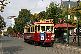
Christchurch Tramway
Christchurch tramway system
The Christchurch tramway system was an extensive network in Christchurch, New Zealand, with steam and horse trams from 1882. Electric trams ran from 1905 to 1954, when the last line to Papanui was replaced by buses...
http://www.tram.co.nz/ operates a one-way tram
Tram
A tram is a passenger rail vehicle which runs on tracks along public urban streets and also sometimes on separate rights of way. It may also run between cities and/or towns , and/or partially grade separated even in the cities...
circuit of the central city. This is mainly marketed as a tourist attraction, but is available to local commuters with an annual season ticket
Season ticket
A season ticket is a ticket that grants privileges over a defined period of time.-Sport:In sport, a season ticket grants the holder access to all regular-season home games for one season without additional charges. The ticket usually offers a discounted price over purchasing a ticket for each of...
. Trams were originally introduced to Christchurch in 1905, ceased operating in 1954, and returned to the newly-built inner city loop in 1995, mainly as a tourist attraction.
Preliminary investigation into light rail options for Christchurch have begun. Investigating options and protecting possible routes is an action point in the City Council's "A City for People Action Plan" (approved in 2010). The new Transport Interchange is being designed to accommodate a future light rail network.
Heavy rail
Commuter rail service was discontinued in the 1970s, while long distance rail travel (by Tranz ScenicTranz Scenic
Tranz Scenic is the long-distance passenger train brand of KiwiRail, formed from the New Zealand Railways Corporation InterCity Rail services. Tranz Scenic was renamed along with the other operating divisions of Tranz Rail in 1995...
) has been scaled back to just TranzCoastal and TranzAlpine
TranzAlpine
The TranzAlpine Express is a passenger train operated by Tranz Scenic in the South Island of New Zealand. This trip is often regarded to be one of the world's great train journeys for the scenery through which it passes . The journey is one-way, taking about four and a half hours...
, which leave from an architecturally controversial station in Riccarton.
Operations
The local bus service (with the exception of The Shuttle) is marketed as Metro and designed, specified, put out to tender and subsidisedSubsidy
A subsidy is an assistance paid to a business or economic sector. Most subsidies are made by the government to producers or distributors in an industry to prevent the decline of that industry or an increase in the prices of its products or simply to encourage it to hire more labor A subsidy (also...
by Environment Canterbury.
Christchurch City Council provides roading infrastructure and street furniture such as signs and seats and regulates parking at bus stop
Bus stop
A bus stop is a designated place where buses stop for passengers to board or leave a bus. These are normally positioned on the highway and are distinct from off-highway facilities such as bus stations. The construction of bus stops tends to reflect the level of usage...
s, and is also owner of Red Bus Ltd through its holding company Christchurch City Holdings
Christchurch City Holdings
Christchurch City Holdings Ltd is a wholly owned investment arm of the Christchurch City Council. The council controlled trading organisations own and run some of the important infrastructure in Christchurch, such as the public transport and electricity delivery in the city.- Lyttelton Port...
. The city council also fully funds the zero-fare The Shuttle service. The city council provided the current central city Bus Exchange in November 2000.
Vehicle safety standards are regulated by the New Zealand Transport Agency
New Zealand Transport Agency
The New Zealand Transport Agency is a New Zealand Crown entity tasked with promoting safe and functional transport by land, including the responsibility for driver and vehicle licensing and investigating rail accidents. It was created on 1 August 2008 by the Land Transport Management Amendment...
.
Cultural references
Christchurch's public transport system served as backdrop for Tim Veling's 2006 book "Red Bus DiaryRed Bus Diary
Red Bus Diary is book by New Zealand photographer Tim Veling. As part of a Masters project Veling spent two years riding Christchurch's public buses with his Leica camera, exploring the city and photographing sights and scenes that caught his interest as well as talking to people and listening to...
", in which the author toured the city on public buses and compiled the stories of the people he met.