

Woolston, New Zealand
Encyclopedia
Woolston is a light industrial and residential suburb of Christchurch
in the South Island
of New Zealand
. It is situated three kilometres southeast of the city centre
, close to major arterial routes including State Highways 73 and 74
to Banks Peninsula
. The Heathcote River
flows through the suburb.
. The Māori
name for the mudflats was "Ohika paruparu" (meaning women gathering shellfish often sank to their thighs in the mud). Some early European records name the western area of Woolston as Roimata, meaning teardrop in Māori. To this day some land titles in this area reference Roimata as their location. More recently the name has been revived by the Roimata Community Incorporated Society (Roimata Community Inc.), which is a geographically and community-based organisation working in Roimata. Its boundaries are defined as Ensors Road, Brougham Street, Ferry Road and Richardson Terrace.
One of the first signs of a growing European community in the Woolston area was the establishment of a Christian church, the Anglican
Parish of St John the Evangelist Woolston, which belongs to the Christchurch diocese. The origins of the Parish date back to 1857 when the first Cob Church was built on the current site. In 1882 a new timber church was built. In 1960 the existing concrete Church building was built and dedicated (consecrated 1963). These church buildings are used daily for worship and many other religious and community activities. It is open to the public on Sundays. It is situated on Ferry Road at the eastern end of Woolston Village. The Parish was officially recognised one year after Christchurch was officially recognised as a City in 1856, the same year that the Anglican Diocese of Christchurch was established. St Johns is one of the oldest Churches in New Zealand.
Woolston initially belonged to the Heathcote District. In the 1850s and 1860s, wharves along the Heathcote River were used by small ships to service the area. Before the Lyttelton Rail Tunnel
was opened in 1867, all the incoming trade arrived in Ferrymead and was transported through Woolston (along Ferry Road) into Christchurch. The road went from the wharf in Lower Heathcote to what is now the corner of High and Madras Streets. The area became quite industrialised after the tunnel opened. Ferry Road later carried the tramlines to Sumner.
 Up until early 1870 the area was commonly referred to as Lower Heathcote. At a meeting about the Heathcote Road drain a local store owner, Joseph Harry Hopkins (1837–1910), named the area Woolston after his birthplace Woolston
in Southampton
, England. On 16 June 1870, in response to a petition to the postmaster-general, Julius Vogel
, objecting to the post office being called Ferry Road, the name Woolston was gazetted. Woolston became a district in 1882, and remained a self-governing borough until 1921, when it was amalgamated with Christchurch.
Joseph Harry Hopkins (1837–1910) was a shopkeeper and postmaster in Woolston who established the Woolston Emporium in 1863. With a building footprint of 5600 square foot, second floor storage and cellar accommodation, this was a rather large store for its time. The Woolston Emporium had six departments: drapery, clothing, boots, grocery, crockery, ironmongery, and a corn store. Hopkins Street, named in 1924, commemorates Joseph Hopkins.
 The Heathcote River provided Woolston much needed water for industries like wool scouring, which needed plentiful water. In 1966 the Woolston industrial sewer was built, and up until that time the river had become increasingly polluted.
Flooding had also become a problem and in 1986 the Woolston Cut began to allow flood waters to bypass a long loop of the river. The 510 metres (1,673.2 ft) long project, which cost NZ$2m, had as a consequence that the trees on the riverbank died as far upstream as the Opawa bridge, and that banks collapsed. Extensive investigations revealed that the trees died from salt water
travelling further upstream with every tide (with the salt killing the trees), that the soil structure changed (a sodium
/ calcium
exchange in the clay
molecules weakened the soils) and the Tunnelling mud crab
had extended its range up the river, further weakening the banks. As a mitigating measure, the Woolston Tidal Barrage was built at the upstream end of the cut, which is only opened in time of floods. During normal flow regimes, the Heathcote remains to flow through what is called the Woolston Loop.
Residential growth from the city gradually moved out through the Woolston area and it is now well merged with Christchurch City. Te Ara, the on-line Encyclopaedia of New Zealand, says that "Factory workers living nearby gave Woolston a strong working-class identity." The area struggles to live up to this positive idea in the present day as there is a significant short term, transient, population.
Woolston is home to The Woolston Drivebys, an indoor football team. The Woolston Brass Band, established in 1891, has gained a national reputation and has won many competitions.
:
Christchurch
Christchurch is the largest city in the South Island of New Zealand, and the country's second-largest urban area after Auckland. It lies one third of the way down the South Island's east coast, just north of Banks Peninsula which itself, since 2006, lies within the formal limits of...
in the South Island
South Island
The South Island is the larger of the two major islands of New Zealand, the other being the more populous North Island. It is bordered to the north by Cook Strait, to the west by the Tasman Sea, to the south and east by the Pacific Ocean...
of New Zealand
New Zealand
New Zealand is an island country in the south-western Pacific Ocean comprising two main landmasses and numerous smaller islands. The country is situated some east of Australia across the Tasman Sea, and roughly south of the Pacific island nations of New Caledonia, Fiji, and Tonga...
. It is situated three kilometres southeast of the city centre
Christchurch Central City
Christchurch Central City is the geographical centre and the heart of Christchurch, New Zealand. It is defined as the area within the four avenues and thus includes the densely built up central city, some less dense surrounding areas of residential, educational and industrial usage, and green...
, close to major arterial routes including State Highways 73 and 74
New Zealand State Highway network
The New Zealand State Highway network is the major national highway network in New Zealand. Just under 100 roads in both the North and South Islands are State Highways...
to Banks Peninsula
Banks Peninsula
Banks Peninsula is a peninsula of volcanic origin on the east coast of the South Island of New Zealand. It has an area of approximately and encompasses two large harbours and many smaller bays and coves...
. The Heathcote River
Heathcote River
The Heathcote River lies within the city boundaries of Christchurch, New Zealand, and is fed from springs near Templetons Road and also receives wet weather flows from as far west as Pound Road. It meanders around the base of the Port Hills from west to south-east.-Course:The catchment of the...
flows through the suburb.
History
In pre-European times the local Māori people gathered food from the mudflats at FerrymeadFerrymead
-Geography:Ferrymead is located on the Avon Heathcote Estuary, close to the point where the Heathcote River drains into the estuary, and three km west of the eventual outflow into Pegasus Bay. To the north lie the oxidation ponds from Christchurch's main sewage treatment works, which are within a...
. The Māori
Maori language
Māori or te reo Māori , commonly te reo , is the language of the indigenous population of New Zealand, the Māori. It has the status of an official language in New Zealand...
name for the mudflats was "Ohika paruparu" (meaning women gathering shellfish often sank to their thighs in the mud). Some early European records name the western area of Woolston as Roimata, meaning teardrop in Māori. To this day some land titles in this area reference Roimata as their location. More recently the name has been revived by the Roimata Community Incorporated Society (Roimata Community Inc.), which is a geographically and community-based organisation working in Roimata. Its boundaries are defined as Ensors Road, Brougham Street, Ferry Road and Richardson Terrace.
One of the first signs of a growing European community in the Woolston area was the establishment of a Christian church, the Anglican
Anglicanism
Anglicanism is a tradition within Christianity comprising churches with historical connections to the Church of England or similar beliefs, worship and church structures. The word Anglican originates in ecclesia anglicana, a medieval Latin phrase dating to at least 1246 that means the English...
Parish of St John the Evangelist Woolston, which belongs to the Christchurch diocese. The origins of the Parish date back to 1857 when the first Cob Church was built on the current site. In 1882 a new timber church was built. In 1960 the existing concrete Church building was built and dedicated (consecrated 1963). These church buildings are used daily for worship and many other religious and community activities. It is open to the public on Sundays. It is situated on Ferry Road at the eastern end of Woolston Village. The Parish was officially recognised one year after Christchurch was officially recognised as a City in 1856, the same year that the Anglican Diocese of Christchurch was established. St Johns is one of the oldest Churches in New Zealand.
Woolston initially belonged to the Heathcote District. In the 1850s and 1860s, wharves along the Heathcote River were used by small ships to service the area. Before the Lyttelton Rail Tunnel
Lyttelton rail tunnel
The Lyttelton Rail Tunnel, initially called the Moorhouse Tunnel, links the city of Christchurch with the port of Lyttelton in the Canterbury region of New Zealand’s South Island. It is the country’s oldest operational rail tunnel, and is on one of the first railway lines in the district...
was opened in 1867, all the incoming trade arrived in Ferrymead and was transported through Woolston (along Ferry Road) into Christchurch. The road went from the wharf in Lower Heathcote to what is now the corner of High and Madras Streets. The area became quite industrialised after the tunnel opened. Ferry Road later carried the tramlines to Sumner.
Woolston, Southampton
Woolston is a suburb of Southampton, Hampshire, located on the eastern bank of the River Itchen. It is bounded by the River Itchen, Hampshire, Sholing, Peartree Green, Itchen and Weston.The area is rich in maritime and aviation history...
in Southampton
Southampton
Southampton is the largest city in the county of Hampshire on the south coast of England, and is situated south-west of London and north-west of Portsmouth. Southampton is a major port and the closest city to the New Forest...
, England. On 16 June 1870, in response to a petition to the postmaster-general, Julius Vogel
Julius Vogel
Sir Julius Vogel, KCMG was the eighth Premier of New Zealand. His administration is best remembered for the issuing of bonds to fund railway construction and other public works...
, objecting to the post office being called Ferry Road, the name Woolston was gazetted. Woolston became a district in 1882, and remained a self-governing borough until 1921, when it was amalgamated with Christchurch.
Joseph Harry Hopkins (1837–1910) was a shopkeeper and postmaster in Woolston who established the Woolston Emporium in 1863. With a building footprint of 5600 square foot, second floor storage and cellar accommodation, this was a rather large store for its time. The Woolston Emporium had six departments: drapery, clothing, boots, grocery, crockery, ironmongery, and a corn store. Hopkins Street, named in 1924, commemorates Joseph Hopkins.
Woolston Cut
Flooding had also become a problem and in 1986 the Woolston Cut began to allow flood waters to bypass a long loop of the river. The 510 metres (1,673.2 ft) long project, which cost NZ$2m, had as a consequence that the trees on the riverbank died as far upstream as the Opawa bridge, and that banks collapsed. Extensive investigations revealed that the trees died from salt water
Seawater
Seawater is water from a sea or ocean. On average, seawater in the world's oceans has a salinity of about 3.5% . This means that every kilogram of seawater has approximately of dissolved salts . The average density of seawater at the ocean surface is 1.025 g/ml...
travelling further upstream with every tide (with the salt killing the trees), that the soil structure changed (a sodium
Sodium
Sodium is a chemical element with the symbol Na and atomic number 11. It is a soft, silvery-white, highly reactive metal and is a member of the alkali metals; its only stable isotope is 23Na. It is an abundant element that exists in numerous minerals, most commonly as sodium chloride...
/ calcium
Calcium
Calcium is the chemical element with the symbol Ca and atomic number 20. It has an atomic mass of 40.078 amu. Calcium is a soft gray alkaline earth metal, and is the fifth-most-abundant element by mass in the Earth's crust...
exchange in the clay
Clay
Clay is a general term including many combinations of one or more clay minerals with traces of metal oxides and organic matter. Geologic clay deposits are mostly composed of phyllosilicate minerals containing variable amounts of water trapped in the mineral structure.- Formation :Clay minerals...
molecules weakened the soils) and the Tunnelling mud crab
Tunnelling mud crab
The tunnelling mud crab, Austrohelice crassa, is a marine large-eyed crab of the family Grapsidae, endemic to the sea coasts of New Zealand. Their carapace width is up to 40 mm....
had extended its range up the river, further weakening the banks. As a mitigating measure, the Woolston Tidal Barrage was built at the upstream end of the cut, which is only opened in time of floods. During normal flow regimes, the Heathcote remains to flow through what is called the Woolston Loop.
Today
In later years Woolston's close proximity to the Lyttelton rail line continued to sustain Woolston as a prime location for industry. Over the 20th century the area grew to become the centre of the New Zealand rubber industry. Other industries grew here and included a nugget factory and a gelatine and glue works. Many of these businesses are still present in one form or another. Woolston hosts Christchurch's largest container terminal.Residential growth from the city gradually moved out through the Woolston area and it is now well merged with Christchurch City. Te Ara, the on-line Encyclopaedia of New Zealand, says that "Factory workers living nearby gave Woolston a strong working-class identity." The area struggles to live up to this positive idea in the present day as there is a significant short term, transient, population.
Woolston is home to The Woolston Drivebys, an indoor football team. The Woolston Brass Band, established in 1891, has gained a national reputation and has won many competitions.
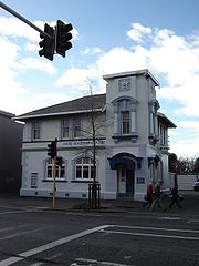
Heritage buildings
Prior to the February 2011 Christchurch earthquake, the following heritage buildings were listed with the New Zealand Historic Places TrustNew Zealand Historic Places Trust
The New Zealand Historic Places Trust is a non-profit trust that advocates for the protection of ancestral sites and heritage buildings in New Zealand...
:
- A & T Burt building, the former Nugget Boot Polish Factory (Category II), built in 1924, it was damaged beyond repair in the February 2011 earthquake and demolished later that year.
- Bloomsbury (Category II), a large residential building at 37 Maunsell Street.
- Jubilee Hospital (Category I), a hospital for the old and infirm established in 1888 in the Woolston Loop. It closed in 1990 and some of the buildings were demolished. The remaining buildings house a fish processing plant.
- Stone Cottage (Category II), built in 1863 from Port Hills stone and these days used as Dizzy Lizzy's restaurant and catering service.
- Whalebone Cottage (Category II), built in ca 1867. Whale ribs used to form an arched gateway for over a century, but those bones are no longer there.
- Woolston Borough Monument (Category II), a monument from 1893.