
Sumner, New Zealand
Encyclopedia
Sumner is a coastal seaside suburb of Christchurch
, New Zealand and was surveyed and named in 1849 in honour of John Bird Sumner, the then newly appointed Archbishop of Canterbury
and president of the Canterbury Association
. Originally a separate borough, it was amalgamated with the city of Christchurch as communications improved and the economies of scale made small town boroughs uneconomic to operate.
for Captain Joseph Thomas, the advanced agent of the Canterbury Association
. His map showed 527 sections and numerous reserved and provisions for churches, schools, cemeteries, town hall, emigration barracks and other town amenities. However, his plans were abandoned through lack of funds and a new survey on which Sumner is based was carried out in 1860.
Captain Thomas named the settlement for Bishop John Sumner, one of the leading members of the Canterbury Association. The Māori
name for the area is Ohikaparuparu ("o" means place of; "hika" means rubbing, kindling, or planting; "paruparu" means dirt, deeply laden, or a preparation of fermented cockles).
The first European to carry out work in Sumner is believed to be Charles Crawford, a whaleboat owner, who transported materials from Port Cooper, now Lyttelton, under contract to build the headquarter and storeroom for Captain Thomas. Sumner was settled in late 1849 or early 1850 by work crews building the road to Lyttelton, Sumner is thus one of the oldest European settlements in the Christchurch area. The Day family was the first to settle permanently in Sumner followed by Edward Dobson and his family. Sumner had its first shop early in 1870, and its proprietor, S.E. Horneman, was postmaster from 1873 until 1876.
In 1885 the Harbour Board granted the concession to build a bath at the East end of Sumner beach. S.L. Bell enclosed some of the sea, built dressing sheds and a tea shop. The bathing pool was a great attraction but every year terrific storms would batter the bath and gradually dump fine sand. Eventually a flood filled the bath with clay and silt from the hills causing its closure.
In 1912 Sumner established its own gasworks and electricity was connected in 1918.
On 22 February 2011, Sumner was hit by the Christchurch earthquake, which destroyed or made uninhabitable a large number of the local houses and commercial buildings. On 13 June the same year, Sumner was hit by another earthquake
of almost the same magnitude as the February event.
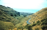
 Sumner is nestled in a coastal valley separated from the adjacent city suburbs by rugged volcanic
hill ridges that end in cliffs that descend to the sea shore in places. Sumner Bay is the first bay on the northern side of Banks Peninsula
and faces Pegasus Bay
and the Pacific Ocean
.
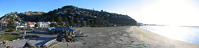
Because of its ocean exposure, a high surf can form in some swell conditions. The beach is gently sloping, with fine grey sand. It is a popular surf beach for these reasons.
Sand dunes have filled the river valley behind the beach. This has made housing construction relatively easy, although flooding at the head of the valley has been a problem in the past due to the reverse slope caused by the sand dunes filling the front of the valley. This has been addressed by a flood drain.
The rocky volcanic outcrop of Cave Rock dominates the beach. There are other rocky outcrops in the area and the volcanic nature of the geology is readily apparent from several of the exposed cliffs around the valley.
A sea wall and wide esplanade have been built along the length of the beach to prevent coastal erosion.
at the western end of the beach, near another large volcanic outcrop known as Shag Rock, or Rapanui
, forms the Sumner bar off shore of Cave Rock. The Sumner bar presents a major hazard to shipping, while the fast currents, strong rips and undertows in the area can be a danger to swimmers.
The Sumner Bar is a sand bar where the estuary meets the sea and is notoriously dangerous to cross. One regular vessel crossing the bar in the early days was the Mullogh, New Zealand’s first iron hulled steamer. On 25 August 1865 the Mullogh ran onto Cave Rock, Sumner, in violent surf. Her cargo of liquor created keen interest on the beach. George Holmes of Pigeon Bay, the contractor for the Lyttelton Rail Tunnel
, then bought the ship, refitted and used her until 1869.
The NZ Trawler Muriel was stranded on Sumner Beach in 1937 and was a total loss and had to be dismantled where she lay.
The Star of the Sea School is a Catholic full primary school, teaching children from years 1 to 8. In 2011, the school has a roll of 121 pupils and is decile 10.
The Van Asch College
takes hearing-impaired children from all over the South Island and the southern North Island. Apart from the Sumner campus, it operates satellite classrooms at Sumner School and at Linwood High School
. In 2011, the school has a roll of 28 pupils and is decile 4.
of some kind almost since its settlement. There is no record of a formal or even informal lifeboat being available prior to the appointment of a pilot in September 1864. However, it is likely that small open rowing boats were available in the bay from the early 1850s.
The Sumner Life Boat Institution has operated a formal life boat or similar rescue craft in the bay since 1898. The traditional name of Rescue have been applied to many of the life boats.
Christchurch
Christchurch is the largest city in the South Island of New Zealand, and the country's second-largest urban area after Auckland. It lies one third of the way down the South Island's east coast, just north of Banks Peninsula which itself, since 2006, lies within the formal limits of...
, New Zealand and was surveyed and named in 1849 in honour of John Bird Sumner, the then newly appointed Archbishop of Canterbury
Archbishop of Canterbury
The Archbishop of Canterbury is the senior bishop and principal leader of the Church of England, the symbolic head of the worldwide Anglican Communion, and the diocesan bishop of the Diocese of Canterbury. In his role as head of the Anglican Communion, the archbishop leads the third largest group...
and president of the Canterbury Association
Canterbury Association
The Canterbury Association was formed in order to establish a colony in what is now the Canterbury Region in the South Island of New Zealand.- Formation of the Association :...
. Originally a separate borough, it was amalgamated with the city of Christchurch as communications improved and the economies of scale made small town boroughs uneconomic to operate.
History
Sumner was surveyed in 1849 by Edward JollieEdward Jollie
Edward Jollie was a pioneer land surveyor in New Zealand, initially as a cadet surveyor with the New Zealand Company. He followed his elder brother Francis Jollie to New Zealand, arriving on the barque Brougham in Wellington in 1842...
for Captain Joseph Thomas, the advanced agent of the Canterbury Association
Canterbury Association
The Canterbury Association was formed in order to establish a colony in what is now the Canterbury Region in the South Island of New Zealand.- Formation of the Association :...
. His map showed 527 sections and numerous reserved and provisions for churches, schools, cemeteries, town hall, emigration barracks and other town amenities. However, his plans were abandoned through lack of funds and a new survey on which Sumner is based was carried out in 1860.
Captain Thomas named the settlement for Bishop John Sumner, one of the leading members of the Canterbury Association. The Māori
Maori language
Māori or te reo Māori , commonly te reo , is the language of the indigenous population of New Zealand, the Māori. It has the status of an official language in New Zealand...
name for the area is Ohikaparuparu ("o" means place of; "hika" means rubbing, kindling, or planting; "paruparu" means dirt, deeply laden, or a preparation of fermented cockles).
The first European to carry out work in Sumner is believed to be Charles Crawford, a whaleboat owner, who transported materials from Port Cooper, now Lyttelton, under contract to build the headquarter and storeroom for Captain Thomas. Sumner was settled in late 1849 or early 1850 by work crews building the road to Lyttelton, Sumner is thus one of the oldest European settlements in the Christchurch area. The Day family was the first to settle permanently in Sumner followed by Edward Dobson and his family. Sumner had its first shop early in 1870, and its proprietor, S.E. Horneman, was postmaster from 1873 until 1876.
In 1885 the Harbour Board granted the concession to build a bath at the East end of Sumner beach. S.L. Bell enclosed some of the sea, built dressing sheds and a tea shop. The bathing pool was a great attraction but every year terrific storms would batter the bath and gradually dump fine sand. Eventually a flood filled the bath with clay and silt from the hills causing its closure.
In 1912 Sumner established its own gasworks and electricity was connected in 1918.
On 22 February 2011, Sumner was hit by the Christchurch earthquake, which destroyed or made uninhabitable a large number of the local houses and commercial buildings. On 13 June the same year, Sumner was hit by another earthquake
June 2011 Christchurch earthquake
The June 2011 Christchurch earthquake was a shallow magnitude 6.3 ML earthquake that occurred on 13 June 2011 at 14:20 NZST . It was centred at a depth of 6.0 km , about 13 km from Christchurch, which had previously been devastated by the February 2011 magnitude 6.3 ML earthquake...
of almost the same magnitude as the February event.
Geography
Volcano
2. Bedrock3. Conduit 4. Base5. Sill6. Dike7. Layers of ash emitted by the volcano8. Flank| 9. Layers of lava emitted by the volcano10. Throat11. Parasitic cone12. Lava flow13. Vent14. Crater15...
hill ridges that end in cliffs that descend to the sea shore in places. Sumner Bay is the first bay on the northern side of Banks Peninsula
Banks Peninsula
Banks Peninsula is a peninsula of volcanic origin on the east coast of the South Island of New Zealand. It has an area of approximately and encompasses two large harbours and many smaller bays and coves...
and faces Pegasus Bay
Pegasus Bay
Pegasus Bay is on the east coast of the South Island of New Zealand.-Location:The bay has a sandy beach and runs from Banks Peninsula to the Waipara River mouth...
and the Pacific Ocean
Pacific Ocean
The Pacific Ocean is the largest of the Earth's oceanic divisions. It extends from the Arctic in the north to the Southern Ocean in the south, bounded by Asia and Australia in the west, and the Americas in the east.At 165.2 million square kilometres in area, this largest division of the World...
.
Because of its ocean exposure, a high surf can form in some swell conditions. The beach is gently sloping, with fine grey sand. It is a popular surf beach for these reasons.
Sand dunes have filled the river valley behind the beach. This has made housing construction relatively easy, although flooding at the head of the valley has been a problem in the past due to the reverse slope caused by the sand dunes filling the front of the valley. This has been addressed by a flood drain.
The rocky volcanic outcrop of Cave Rock dominates the beach. There are other rocky outcrops in the area and the volcanic nature of the geology is readily apparent from several of the exposed cliffs around the valley.
A sea wall and wide esplanade have been built along the length of the beach to prevent coastal erosion.
Sumner bar
The outlet of the Avon Heathcote EstuaryAvon Heathcote Estuary
The Avon Heathcote Estuary is the largest semi-enclosed shallow estuary in Canterbury and remains one of New Zealand’s most important coastal wetlands. It is well known as an internationally important habitat for migratory birds, and it is an important recreational playground and educational resource...
at the western end of the beach, near another large volcanic outcrop known as Shag Rock, or Rapanui
Rapanui Rock
Rapanui, better known as The Shag Rock or simply "Shag Rock" was a notable sea stack which stood at the entrance of the Avon Heathcote Estuary near Christchurch, New Zealand. The boating channel into the estuary lies on the northern side of the rock. Although not used as a shipping port, the...
, forms the Sumner bar off shore of Cave Rock. The Sumner bar presents a major hazard to shipping, while the fast currents, strong rips and undertows in the area can be a danger to swimmers.
The Sumner Bar is a sand bar where the estuary meets the sea and is notoriously dangerous to cross. One regular vessel crossing the bar in the early days was the Mullogh, New Zealand’s first iron hulled steamer. On 25 August 1865 the Mullogh ran onto Cave Rock, Sumner, in violent surf. Her cargo of liquor created keen interest on the beach. George Holmes of Pigeon Bay, the contractor for the Lyttelton Rail Tunnel
Lyttelton rail tunnel
The Lyttelton Rail Tunnel, initially called the Moorhouse Tunnel, links the city of Christchurch with the port of Lyttelton in the Canterbury region of New Zealand’s South Island. It is the country’s oldest operational rail tunnel, and is on one of the first railway lines in the district...
, then bought the ship, refitted and used her until 1869.
The NZ Trawler Muriel was stranded on Sumner Beach in 1937 and was a total loss and had to be dismantled where she lay.
Education
Sumner School was founded in 1876 and is these days a full primary school, teaching children from years 1 to 8. The school has, as of 2011, a roll of 435 pupils and is decile 10.The Star of the Sea School is a Catholic full primary school, teaching children from years 1 to 8. In 2011, the school has a roll of 121 pupils and is decile 10.
The Van Asch College
Van Asch College
Van Asch Deaf Education Centre is located in Truro Street, Sumner, Christchurch, New Zealand. It is a special school for deaf children, accepting both day and residential pupils, as well being as a resource centre providing services and support for parents, mainstream students and their...
takes hearing-impaired children from all over the South Island and the southern North Island. Apart from the Sumner campus, it operates satellite classrooms at Sumner School and at Linwood High School
Linwood High School
Linwood High School is a non-denominational comprehensive state secondary school in Linwood, Renfrewshire.The original school building was constructed in 1965 and demolished in 2006 for a new school to be constructed on the same site....
. In 2011, the school has a roll of 28 pupils and is decile 4.
Sumner Life Boat Institution
Because of the hazard posed by the Sumner Bar, Sumner has had a lifeboatLifeboat (rescue)
A rescue lifeboat is a boat rescue craft which is used to attend a vessel in distress, or its survivors, to rescue crewmen and passengers. It can be hand pulled, sail powered or powered by an engine...
of some kind almost since its settlement. There is no record of a formal or even informal lifeboat being available prior to the appointment of a pilot in September 1864. However, it is likely that small open rowing boats were available in the bay from the early 1850s.
The Sumner Life Boat Institution has operated a formal life boat or similar rescue craft in the bay since 1898. The traditional name of Rescue have been applied to many of the life boats.