
Heathcote Valley
Encyclopedia
Location
The suburb is dominated by the approaches to the Lyttelton road tunnelLyttelton Road Tunnel
The Lyttelton road tunnel links the New Zealand city of Christchurch and its seaport, Lyttelton. It opened in 1964 and carries just over 10,000 vehicles/day...
, a major arterial that passes through the Port Hills
Port Hills
The Port Hills form the northern rim of the ancient Lyttelton volcano, separating the port of Lyttelton from the city of Christchurch in Canterbury, New Zealand...
. The road is part of the State Highway 74
New Zealand State Highway network
The New Zealand State Highway network is the major national highway network in New Zealand. Just under 100 roads in both the North and South Islands are State Highways...
network. The Main South Railway line
Main South Line
The Main South Line, sometimes referred to as part of the South Island Main Trunk Railway, is a railroad line that runs north and south from Lyttelton in New Zealand through Christchurch and along the east coast of the South Island to Invercargill via Dunedin...
passes through the suburb, before entering the Lyttelton rail tunnel
Lyttelton rail tunnel
The Lyttelton Rail Tunnel, initially called the Moorhouse Tunnel, links the city of Christchurch with the port of Lyttelton in the Canterbury region of New Zealand’s South Island. It is the country’s oldest operational rail tunnel, and is on one of the first railway lines in the district...
that connects with the port of Lyttelton
Lyttelton, New Zealand
Lyttelton is a port town on the north shore of Lyttelton Harbour close to Banks Peninsula, a suburb of Christchurch on the eastern coast of the South Island of New Zealand....
.
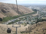
The suburb is nestled at the foot of the steep volcanic crags that form the northern edge of the hills, some eight kilometres southeast of the city centre. Heathcote Valley is also the starting point of the Christchurch Gondola, which goes up to Mount Cavendish
Mount Cavendish
Mount Cavendish is located in the Port Hills. It affords spectacular views of Christchurch, New Zealand and Lyttelton. It is part of the crater wall of the extinct volcano that formed Lyttelton Harbour, and the peak itself is one of the notable features that give the rugged skyline of the crater...
on the Port Hills. The Gondola officially opened on 24 November 1992.
History
Heathcote Valley has a long history of MaltMalt
Malt is germinated cereal grains that have been dried in a process known as "malting". The grains are made to germinate by soaking in water, and are then halted from germinating further by drying with hot air...
ing, the latest being the Canterbury Malting Company. The disused Maltworks, which closed in 1999, dominate the skyline.
Relation to Heathcote River
Despite its name, Heathcote Valley is situated some two kilometres south of the Heathcote RiverHeathcote River
The Heathcote River lies within the city boundaries of Christchurch, New Zealand, and is fed from springs near Templetons Road and also receives wet weather flows from as far west as Pound Road. It meanders around the base of the Port Hills from west to south-east.-Course:The catchment of the...
, which does not flow through the suburb but rather flows east across a wide plain.
Naming
The suburb is named after Sir William Heathcote, secretary of the Canterbury AssociationCanterbury Association
The Canterbury Association was formed in order to establish a colony in what is now the Canterbury Region in the South Island of New Zealand.- Formation of the Association :...
.