

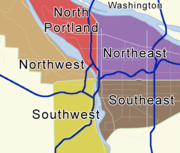
Portland, Oregon neighborhoods
Encyclopedia
Portland, Oregon
Portland is a city located in the Pacific Northwest, near the confluence of the Willamette and Columbia rivers in the U.S. state of Oregon. As of the 2010 Census, it had a population of 583,776, making it the 29th most populous city in the United States...
neighborhood is represented by a volunteer-based neighborhood association which serves as a liaison between residents of the neighborhood and the city government, as coordinated by the city's Office of Neighborhood Involvement (ONI). The city provides funding to this "network of neighborhoods" through seven neighborhood district coalitions, geographical groupings of neighborhood associations.
Southwest

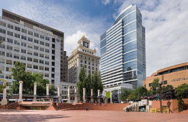
Downtown Portland
Downtown Portland, the city center of Portland, Oregon, United States, is located on the west bank of the Willamette River. It is in the northeastern corner of the southwest section of the city and is where most of the city's high-rise buildings are found....
lies in the Southwest section between the I-405 freeway loop and the Willamette River, centered around Pioneer Courthouse Square
Pioneer Courthouse Square
Pioneer Courthouse Square, affectionately known as Portland's living room, is a public space occupying a full 40,000 ft² city block in the center of downtown Portland, Oregon, United States...
("Portland's living room"). Downtown and many other parts of inner Portland have compact square blocks (200 ft [60 m] on a side) and narrow streets (64 ft [20 m] wide), a pedestrian-friendly combination.
Many of Portland's recreational, cultural, educational, governmental, business, and retail resources are concentrated downtown, including:
- South Park Blocks, Pettygrove and Lovejoy Parks, and Tom McCall Waterfront ParkTom McCall Waterfront ParkGovernor Tom McCall Waterfront Park is a park located on the west bank of the Willamette River in downtown Portland, Oregon. It is , comprising 16 tax lots owned by the City of Portland....
- Arlene Schnitzer Concert HallArlene Schnitzer Concert HallThe Arlene Schnitzer Concert Hall , opened as the Portland Publix Theater before becoming the Paramount after 1930, is a historic theater building and performing arts center in Portland, Oregon, United States...
, Portland Art MuseumPortland Art MuseumThe Portland Art Museum in Portland, Oregon, United States, was founded in 1892, making it the oldest art museum on the West Coast and seventh oldest in the United States. Upon completion of the most recent renovations, the Portland Art Museum became one of the twenty-five largest art museums in...
, and Oregon Historical Society MuseumOregon Historical SocietyThe Oregon Historical Society is an organization that encourages and promotes the study and understanding of the history of the Oregon Country, within the broader context of U.S. history. Incorporated in 1898, the Society collects, preserves, and makes available materials of historical character... - Portland City HallPortland City Hall (Oregon)Portland City Hall is the headquarters of city government of Portland, Oregon, United States. The four-story Italian Renaissance-style building houses the offices of the City Council, which consists of the mayor and four commissioners, and several other offices. City Hall is also home to the City...
, Multnomah County Courthouse, the Portland Building, Pioneer CourthousePioneer CourthouseThe Pioneer Courthouse is a federal courthouse in Portland, Oregon, United States. Built beginning in 1869, the structure is the oldest federal building in the Pacific Northwest, and the second oldest west of the Mississippi River. Along with Pioneer Courthouse Square, it serves as the center of...
, and Mark O. Hatfield United States CourthouseMark O. Hatfield United States CourthouseThe Mark O. Hatfield United States Courthouse is a federal courthouse in Portland, Oregon. It is named in honor of former U.S. Senator Mark O. Hatfield. It is used by the United States District Court for the District of Oregon.... - Portland State UniversityPortland State UniversityPortland State University is a public state urban university located in downtown Portland, Oregon, United States. Founded in 1946, it has the largest overall enrollment of any university in the state of Oregon, including undergraduate and graduate students. It is also the only public university in...
, with the largest student body of any in Oregon - The Meier & Frank BuildingMeier & Frank BuildingThe Meier & Frank Building is a fifteen story, glazed terra cotta building located in downtown Portland, Oregon, across from the northeast corner of Pioneer Courthouse Square. The building is the former flagship store and headquarters building for the Meier & Frank department store chain and has...
and Pioneer PlacePioneer PlacePioneer Place is an upscale, urban shopping mall in downtown Portland, Oregon. It consists of four blocks of retail, dining, parking, and an office tower named Pioneer Tower. The mall itself is spread out between four buildings, interconnected by skywalks or underground mall sections...
mall - Wells Fargo CenterWells Fargo Center (Portland, Oregon)Wells Fargo Center is an office building located in Portland, Oregon, United States. The tower rises 546 feet with 40 floors of office space and three levels of parking below the surface...
, the tallest building in Oregon (546 feet [166 m])
Beyond downtown, the Southwest section also includes:
- The campuses of Oregon Health & Science UniversityOregon Health & Science UniversityOregon Health & Science University is a public university in Oregon with a main campus, including two hospitals, in Portland and a smaller campus in Hillsboro...
(OHSU), Lewis & Clark CollegeLewis & Clark CollegeLewis & Clark College is a private institution of higher learning located in Portland, Oregon. Made up of an undergraduate College of Arts and Sciences, a School of Law, and a Graduate School of Education and Counseling. Lewis & Clark is a member of the Annapolis Group of colleges with athletic...
, and Portland Community CollegePortland Community CollegePortland Community College is Oregon's largest community college, located in Portland, United States. It serves over one million residents in the five county area of Multnomah, Washington, Yamhill, Clackamas, and Columbia...
/Sylvania - Neighborhoods like South Portland (formerly Corbett-Terwilliger-Lair Hill), South BurlingameSouth Burlingame, Portland, OregonSouth Burlingame is a neighborhood in the Southwest section of Portland, Oregon. It is bordered by Multnomah to the west, Hillsdale and South Portland to the north, River View Cemetery to the east, and Markham, Marshall Park, and Collins View to the south.Interstate 5 cuts through the northern...
, Hillsdale, and Multnomah, with unique residential houses and well defined commercial and retail districts - Alpenrose DairyAlpenrose DairyAlpenrose Dairy is a dairy company located in the Hayhurst neighborhood of southwest Portland, Oregon since 1916. It has been in the Cadonau family for several generations and was named after the alpine rose by the Swiss-born wife and early co-owner of the dairy.The grounds of the dairy...
in the HayhurstHayhurst, Portland, OregonHayhurst is a neighborhood in the Southwest section of Portland, Oregon, on the border with Washington County...
neighborhood, the grounds of which host track cyclingTrack cyclingTrack cycling is a bicycle racing sport usually held on specially built banked tracks or velodromes using track bicycles....
and Little LeagueLittle LeagueLittle League Baseball and Softball is a non-profit organization in South Williamsport, Pennsylvania, United States which organizes local youth baseball and softball leagues throughout the U.S...
sports - Washington Park, site of North AmericaNorth AmericaNorth America is a continent wholly within the Northern Hemisphere and almost wholly within the Western Hemisphere. It is also considered a northern subcontinent of the Americas...
's deepest transit stationWashington Park (MAX station)Washington Park is a station in the MAX Light Rail system of TriMet, served by the Blue and Red lines. It is located in Portland, Oregon and is a part of the Robertson Tunnel under Portland's West Hills. It is the fourth station westbound on the Westside MAX alignment...
, the Oregon ZooOregon ZooThe Oregon Zoo, formerly the Washington Park Zoo, is a zoo in Portland, the largest city in the U.S. state of Oregon. Located southwest of Downtown Portland, the zoo is inside Portland's Washington Park, and includes a narrow-gauge railway that connects to the International Rose Test Garden inside...
, Hoyt ArboretumHoyt ArboretumThe Hoyt Arboretum is located atop a ridge in the west hills of Portland, Oregon, United States. It was founded in 1922 by a collection of timber industry representatives, the U.S...
, the International Rose Test GardenInternational Rose Test GardenThe International Rose Test Garden is a rose garden in Washington Park in Portland, Oregon, United States. There are over 7,000 rose plants of approximately 550 varieties. The roses bloom from April through October with the peak coming in June, depending on the weather...
, the Portland Japanese GardenPortland Japanese GardenThe Portland Japanese Garden is a traditional Japanese garden occupying 5.5 acres , located within Washington Park in the west hills of Portland, Oregon, USA.- Design :...
, the Vietnam Veterans Memorial, and many hiking trails. - The south Willamette riverfrontSouth WaterfrontThe South Waterfront is a high-rise district under construction on former brownfield industrial land in the South Portland neighborhood south of downtown Portland, Oregon, U.S. It is one of the largest urban redevelopment projects in the United States...
along SW Macadam Ave., over 100 acres (0.4 km²) of former industrial land. This area is undergoing redevelopment as a mixed-use, high-density neighborhood, with an anticipated 2,700 residential units and 5,000 high-tech jobs after build-out.
Northwest
Pearl District, Portland, Oregon
The Pearl District is an area of Portland, Oregon, formerly occupied by warehouses, light industry and railroad classification yards and now noted for its art galleries, upscale businesses and residences. The area has been undergoing significant urban renewal since the late 1990s, including the...
, most of Old Town Chinatown
Old Town Chinatown, Portland, Oregon
Old Town Chinatown is a neighborhood in the Northwest section of Portland, Oregon. The Willamette River forms its eastern boundary, separating it from the Lloyd District and the Kerns and Buckman neighborhoods...
, the Northwest District
Northwest District, Portland, Oregon
The Northwest District is a densely populated retail and residential neighborhood in the Northwest section of Portland, Oregon. Craftsman- and Old Portland-style houses are packed tightly together with grand old apartment buildings and sleek new condominiums, within walking distance of...
, and various residential and industrial neighborhoods. A range of streets primarily in Northwest Portland is named alphabetically from Ankeny through York (the street following York is Reed Street). The street between Wilson and York was called "X Street" until it was renamed as Roosevelt Street. Burnside Street, the "B" in the sequence, divides the Northeast and Northwest quadrants of the city from the Southeast and Southwest.
The Pearl District is a recent name for a former warehouse
Warehouse
A warehouse is a commercial building for storage of goods. Warehouses are used by manufacturers, importers, exporters, wholesalers, transport businesses, customs, etc. They are usually large plain buildings in industrial areas of cities and towns. They usually have loading docks to load and unload...
and industrial area just north of downtown. Many of the warehouses have been converted into loft
Loft
A loft can be an upper story or attic in a building, directly under the roof. Alternatively, a loft apartment refers to large adaptable open space, often converted for residential use from some other use, often light industrial...
s, and new multistory condominiums have also been developed on previously vacant land. The increasing density has attracted a mix of restaurants, brewpubs, shops, and art galleries. The galleries sponsor simultaneous artists' receptions every month, in an event known as First Thursday.
Between the Pearl District and the Willamette is the Old Town Chinatown neighborhood. It includes Portland's Chinatown
Chinatown
A Chinatown is an ethnic enclave of overseas Chinese people, although it is often generalized to include various Southeast Asian people. Chinatowns exist throughout the world, including East Asia, Southeast Asia, the Americas, Australasia, and Europe. Binondo's Chinatown located in Manila,...
, marked by a pair of lions
Chinese guardian lions
Chinese guardian lions, known as Shishi lions or Imperial guardian lion, and often incorrectly called "Foo Dogs" in the West, are a common representation of the lion in pre-modern China...
at its entrance at NW 4th Ave. and W Burnside St. and home to the Portland Classical Chinese Garden. Before World War II
World War II
World War II, or the Second World War , was a global conflict lasting from 1939 to 1945, involving most of the world's nations—including all of the great powers—eventually forming two opposing military alliances: the Allies and the Axis...
, this area was known as Japan Town; Chinatown was previously located just south of W. Burnside St. along the riverfront.
Further west is the compact but thriving NW 21st and 23rd Avenue restaurant and retail area, the core of the Northwest District. Parts of this area are also called Uptown and Nob Hill. Nicknames include Snob Hill and Trendy Third. The residential areas adjacent to the shopping district include the Alphabet Historic District (with large Victorian and Craftsman homes built in the years before and shortly after 1900) and a large district centered around Wallace Park. The neighborhood has a mix of Victorian-era houses, apartment buildings from throughout the 20th century, and various businesses centered around Legacy Good Samaritan Medical Center. The Portland Streetcar
Portland Streetcar
The Portland Streetcar is a streetcar system in Portland, Oregon, that opened in 2001 and serves areas surrounding downtown Portland. It is currently a single line that is almost long and serves some 12,000 daily riders, but a second line is expected to open in 2012.As with the heavier-duty MAX...
connects Nob Hill to downtown, via the Pearl.
West of the developed areas is the northern portion of Portland's West Hills, including the majority of extensive Forest Park
Forest Park, Portland, Oregon
Forest Park, a neighborhood on the northwestern edge of Portland, Oregon, combines rolling green pastures, views east and west, and proximity to the attractions of Northwest District. The Forest Park neighborhood is named because of its proximity to Forest Park, the southern portion of which lies...
and the Willamette Heights, Hillside, Sylvan, Skyline and Forest Heights neighborhoods.
North

Portland International Raceway
Portland International Raceway is located in Portland, Oregon, USA's, Delta Park complex on the former site of Vanport, just south of the Columbia River. It is west of a light rail station and less than a mile west of Interstate 5....
, the University of Portland
University of Portland
The University of Portland is a private Roman Catholic university located in Portland, Oregon. It is affiliated with the Congregation of Holy Cross and is the sister school of the University of Notre Dame. Founded in 1901, UP has a student body of about 3,600 students...
, and massive cargo facilities of the Port of Portland
Port of Portland (Oregon)
The Port of Portland is the port district responsible for overseeing Portland International Airport, general aviation, and marine activities in the Portland, Oregon metropolitan area in the United States....
. Slang-names for it include "NoPo" (shortened from North Portland) and "the Fifth Quadrant" (for being the odd-man out from the four-cornered logic of SE, NE, SW, and NW).
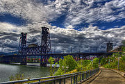
North Portland is connected to the industrial area of Northwest Portland by the St. Johns Bridge
St. Johns Bridge
The St. Johns Bridge is a steel suspension bridge that spans the Willamette River in Portland, Oregon, USA, between the St. Johns neighborhood and the northwest industrial area around Linnton. It is the only suspension bridge in the Willamette Valley and one of three public highway suspension...
, a 2067 ft (630 m) long suspension bridge completed in 1931 and extensively rehabilitated in 2003-05.
During World War II
World War II
World War II, or the Second World War , was a global conflict lasting from 1939 to 1945, involving most of the world's nations—including all of the great powers—eventually forming two opposing military alliances: the Allies and the Axis...
, a planned development named Vanport
Vanport, Oregon
Vanport City was a hastily constructed city of public housing located in Multnomah County, Oregon, United States, between the contemporary Portland city boundary and the Columbia River. It is currently the site of Delta Park and the Portland International Raceway.It was constructed in 1943 to house...
was constructed to the north of this section between the city limits and the Columbia River
Columbia River
The Columbia River is the largest river in the Pacific Northwest region of North America. The river rises in the Rocky Mountains of British Columbia, Canada, flows northwest and then south into the U.S. state of Washington, then turns west to form most of the border between Washington and the state...
. It grew to be the second largest city in Oregon, but was wiped out by a disastrous flood in 1948. Columbia Villa, another wartime housing project in the Portsmouth Neighborhood, is being rebuilt; the renewed community opened in 2005 is known as New Columbia and offers public housing, rental housing, and single family home ownership units. Since 2004, a light rail line runs along Interstate Avenue
MAX Yellow Line
The MAX Yellow Line is a 5.8-mile route in the Metropolitan Area Express light rail system in Portland, Oregon. The route, which opened May 1, 2004, runs between Portland State University , in downtown Portland, and the Portland Expo Center...
, which parallels I-5, stopping short of crossing the Columbia River.
Northeast
Irvington, Portland, Oregon
Irvington is a neighborhood in the Northeast section of Portland, Oregon. According to the city's Office of Neighborhood Involvement, it consists of a rectanglar area extending east to west from NE 7th Ave. to NE 26th Ave., and north to south from NE Fremont St. to NE Broadway...
and the Alameda Ridge
Alameda Ridge
The Alameda Ridge is a large gravel bar located in Portland, Oregon, United States.-Geologic history:Alameda Ridge was formed between 15,000 and 13,000 years ago at the end of the last ice age when the ice dam containing Glacial Lake Missoula collapsed some 40 times, causing some of the...
feature some of the oldest and most expensive homes in Portland, nearby King
King, Portland, Oregon
King is a neighborhood in the Northeast section of Portland, Oregon. Like many of the surrounding neighborhoods, King has historically had one of the highest proportions of minority ancestry in the city. Census data taken 2010 show that the neighborhood is 53% to 69% white in the six census tracts...
is a more working-class neighborhood. Because it is so large, Northeast Portland can essentially be divided ethnically, culturally, and geographically into inner and outer sections. The inner Northeast neighborhoods that surround Martin Luther King Jr. Blvd. were once predominantly African American, resembling typical urban inner-city environments found in most major U.S. cities. However, the demographics are now changing due to the process of gentrification
Gentrification
Gentrification and urban gentrification refer to the changes that result when wealthier people acquire or rent property in low income and working class communities. Urban gentrification is associated with movement. Consequent to gentrification, the average income increases and average family size...
. The King area is currently 37.4% Black or African-American. Inner Northeast includes several shopping areas, such as the Lloyd District
Lloyd District, Portland, Oregon
The Lloyd District is a primarily commercial neighborhood in the North and Northeast sections of Portland, Oregon. It is named after Ralph Lloyd , a California rancher, oilman, and real estate developer who moved to and started the development of the area.The Lloyd District is bounded by the...
, Alberta
Alberta Street, Portland, Oregon
Alberta Street is a thoroughfare in Portland, Oregon, United States, stretching through the North and Northeast sections of the city and crossing Interstate 5....
Arts District and Hollywood, and part of the affluent Irvington
Irvington, Portland, Oregon
Irvington is a neighborhood in the Northeast section of Portland, Oregon. According to the city's Office of Neighborhood Involvement, it consists of a rectanglar area extending east to west from NE 7th Ave. to NE 26th Ave., and north to south from NE Fremont St. to NE Broadway...
, Alameda
Alameda, Portland, Oregon
Alameda is a neighborhood in Portland, Oregon, United States that is located on the Alameda Ridge with views of Downtown, the Willamette River, and the Cascades. Northeast Fremont Street is the neighborhood’s main east-west thoroughfare and NE 33rd, its main north-south thoroughfare, makes up its...
, Grant Park
Grant Park, Portland, Oregon
Grant Park is a neighborhood and park in the Northeast section of Portland, Oregon. The neighborhood is bordered by Alameda and Beaumont-Wilshire to the north, Rose City Park to the east, Hollywood District, Laurelhurst, and Sullivan's Gulch to the south, and Irvington to the west, and best known...
and Laurelhurst
Laurelhurst, Portland, Oregon
Laurelhurst is a neighborhood of vintage homes and undulating streets surrounding a park of the same name, straddling the NE and SE sections of Portland. Stone markers flank the entrances to the area...
neighborhoods and nearby developments. The city plan targets Lloyd District as another mixed-use area, with high-density residential development.
Straddling the base of the borders of North and Northeast is the Rose Quarter. It is named after the Rose Garden, home of the Portland Trail Blazers
Portland Trail Blazers
The Portland Trail Blazers, commonly known as the Blazers, are an American professional basketball team based in Portland, Oregon. They play in the Northwest Division of the Western Conference in the National Basketball Association . The Trail Blazers originally played their home games in the...
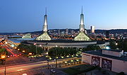
, and also includes the Blazers' former home, the Memorial Coliseum. The Coliseum is the home to Portland's hockey team, the Portland Winter Hawks
Portland Winter Hawks
The Portland Winterhawks are a major junior ice hockey team based in Portland, Oregon, playing in the Western Hockey League, a member league in the Canadian Hockey League. They play their home games at the Memorial Coliseum, though typically a few games each season are also played in the...
, of the Western Hockey League
Western Hockey League
The Western Hockey League is a major junior ice hockey league based in Western Canada and the Northwestern United States. The WHL is one of three leagues that constitute the Canadian Hockey League as the highest level of junior hockey in Canada...
, though they often play at the Rose Garden. The newest Rose Quarter tenants are the LumberJax
Portland Lumberjax
The Portland LumberJax were a professional lacrosse team in the National Lacrosse League , which started playing in the 2006 season and ended operations after the 2009 season. Announced by the NLL on May 11, 2005, the LumberJax played their home games at the Rose Garden in Portland, Oregon...
of the National Lacrosse League
National Lacrosse League
The National Lacrosse League is a men's professional indoor lacrosse league in North America. It currently has nine teams; three in Canada and six in the United States. Unlike other lacrosse leagues which play in the summer, the NLL plays its games in the winter and spring. Each year, the playoff...
. The city still holds the lease to the land and owns the Coliseum, but the Rose Garden and other buildings were owned by private business interests until they went into receivership. The area is quite active during the teams' home games, and the city hopes to extend the activity by promoting a major increase in residential units in the quarter using zoning and tax incentives.
At the base of Northeast where its border meets Southeast, an area near the Burnside Bridge has been redeveloped into a bustling nightlife and entertainment district. The area features bars like The Chesterfield and music venues like The Doug Fir Lounge. In 2006, the area was established enough to get its own nickname: LoBU.
Southeast
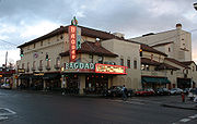
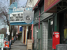
Hawthorne, Portland, Oregon
The Hawthorne District in Portland, Oregon is an area of Southeast Portland on SE Hawthorne Blvd., particularly between 30th and 42nd Avenues. The area has numerous retail stores, including clothing shops, restaurants, bars, brewpubs and microbreweries. Hawthorne district is known for its young,...
and Belmont
Belmont, Portland, Oregon
The Belmont Area is a retail and residential district running along SE Belmont St. in the inner Southeast section of Portland, Oregon in a parallel fashion to the Hawthorne District, 6 blocks to the south. From west to east the area extends 48 blocks, from SE 12th Ave. to SE 60th Ave., passing...
districts out to Gresham
Gresham, Oregon
- Demographics :As of the census of 2000, there were 90,205 people, 33,327 households, and 22,695 families residing in the city. The population density was 4,071.6 people per square mile . There were 35,309 housing units at an average density of 1,593.8 per square mile...
. Southeast Portland has blue-collar roots and has evolved to encompass a wide mix of backgrounds.The Hawthorne district in particular is known for its hippie/radical crowd and small subculturally-oriented shops; not far away is Reed College
Reed College
Reed College is a private, independent, liberal arts college located in southeast Portland, Oregon. Founded in 1908, Reed is a residential college with a campus located in Portland's Eastmoreland neighborhood, featuring architecture based on the Tudor-Gothic style, and a forested canyon wilderness...
, whose campus expands from Woodstock Boulevard to Steele Street, and from the 28th to the 39th Avenues.
Between the 1920s and the 1960s, Southeast was home to Lambert Gardens
Lambert Gardens
Lambert Gardens was a private botanical garden of over 30 acres in the Reed neighborhood of Portland, Oregon, United States, north of Reed College at SE 28th Ave. and SE Steele St...
. Southeast Portland also features Mt. Tabor, a cinder cone volcano
Cinder cone
According to the , Cinder Cone is the proper name of 1 cinder cone in Canada and 7 cinder cones in the United States:In Canada: Cinder Cone In the United States:...
that has become one of Portland's more scenic and popular parks.
Official list of neighborhoods
Each neighborhood association defines its own boundaries, which may include areas outside of Portland city limits and (if mutually agreed) areas that overlap with other neighborhoods. Neighborhoods may span boundaries between the five sections (N, NE, SE, SW, and NW) of the city as well. The segmentation adopted here is based on ONI's district coalition model, under which each neighborhood is part of at most one coalition (though some neighborhoods are not included in any).Neighbors West/Northwest (NWNW)
- Arlington HeightsArlington Heights, Portland, OregonArlington Heights is a neighborhood in Portland of grand houses and some of the city’s most renowned parks, such as the Japanese Garden.-Elementary Schools:Ainsworth Elementary School2425 SW Vista Dr.- Parks :...
- Forest ParkForest Park, Portland, OregonForest Park, a neighborhood on the northwestern edge of Portland, Oregon, combines rolling green pastures, views east and west, and proximity to the attractions of Northwest District. The Forest Park neighborhood is named because of its proximity to Forest Park, the southern portion of which lies...
- Goose HollowGoose Hollow, Portland, OregonGoose Hollow is a neighborhood in southwest Portland, Oregon. It acquired its distinctive name through early residents’ practice of letting their geese run free near the wooded ravine in the Tualatin Mountains now known as the Tanner Creek Canyon and in the now infilled Tanner Creek Gulch...
- HillsideHillside, Portland, OregonHillside is a Northwest Portland neighborhood in the city's West Hills. It is anchored by the Hillside Community Center, the former site of Catlin Gabel School, which was designed by noted architect Pietro Belluschi. The center features neighborhood meeting spaces, a soccer field and a basketball...
- LinntonLinnton, Portland, OregonLinnton is a Portland, Oregon neighborhood located between Forest Park and the Willamette River along U.S. Route 30 , close to the agricultural community of Sauvie Island. It borders the neighborhoods of Northwest Industrial on the south, St. Johns and Cathedral Park via the St...
- Northwest DistrictNorthwest District, Portland, OregonThe Northwest District is a densely populated retail and residential neighborhood in the Northwest section of Portland, Oregon. Craftsman- and Old Portland-style houses are packed tightly together with grand old apartment buildings and sleek new condominiums, within walking distance of...
(includes Uptown, Nob Hill, Alphabet Historic District) - Northwest HeightsNorthwest Heights, Portland, OregonNorthwest Heights is a neighborhood on the west side of Portland's West Hills. The neighborhood’s main thoroughfare is NW Skyline Boulevard, which snakes along the spine of the hills, with pockets of residential development cascading down the slopes. The neighborhood is close to the dining,...
- Northwest IndustrialNorthwest Industrial, Portland, OregonNorthwest Industrial is an almost entirely industrial neighborhood in the Northwest section of Portland. According to the Portland Bureau of Planning, it "is one of the few remaining large urban industrial districts in the United States" and "one of the premier heavy industrialdistricts in the...
- Old Town ChinatownOld Town Chinatown, Portland, OregonOld Town Chinatown is a neighborhood in the Northwest section of Portland, Oregon. The Willamette River forms its eastern boundary, separating it from the Lloyd District and the Kerns and Buckman neighborhoods...
- Pearl DistrictPearl District, Portland, OregonThe Pearl District is an area of Portland, Oregon, formerly occupied by warehouses, light industry and railroad classification yards and now noted for its art galleries, upscale businesses and residences. The area has been undergoing significant urban renewal since the late 1990s, including the...
- Pinnacle
- Portland Downtown
- Sylvan-HighlandsSylvan-Highlands, Portland, OregonSylvan-Highlands is a Portland, Oregon neighborhood located on the west side of the West Hills.-Elementary schools:Chapman Elementary School2425 SW Vista Dr.- Parks :*Children's Museum - 4015 SW Canyon Rd.*Oregon Zoo and Washington Park...
These are in Northwest Portland, except Arlington Heights, Goose Hollow, Portland Downtown, and Sylvan-Highlands, which are in Southwest Portland.
Southwest Neighborhoods, Inc. (SWNI)
- Arnold CreekArnold Creek, Portland, OregonArnold Creek is a neighborhood in the Southwest section of Portland, Oregon, just north of the city of Lake Oswego and Clackamas County...
- AshcreekAshcreek, Portland, OregonAshcreek is a Southwest Portland, Oregon neighborhood. It borders Maplewood to the north, Multnomah and Crestwood to the east, Far Southwest to the south, and the Washington County communities of Garden Home-Whitford and Tigard to the west...
- BridlemileBridlemile, Portland, OregonBridlemile is a Southwest Portland, Oregon neighborhood in the West Hills. The Portland city boundary runs through the neighborhood such that the southern part of the neighborhood is within Portland proper, but the northern portion is unincorporated Multnomah County...
(includes Glencullen) - Collins ViewCollins View, Portland, OregonCollins View is a neighborhood in the Southwest section of Portland, Oregon.It borders the neighborhoods of Marshall Park and Arnold Creek to the west, Tryon Creek State Natural Area to the south, Dunthorpe and River View Cemetery to the east, and the South Burlingame neighborhood to the north.The...
- CrestwoodCrestwood, Portland, OregonCrestwood is a neighborhood in the Southwest section of Portland, Oregon located between SW 45th Ave. and Barbur Blvd., adjacent to Multnomah and Ashcreek. Woods Memorial Natural Area is located here, a swath of urban wilderness visited on occasion by elk....
- Far SouthwestFar Southwest, Portland, OregonFar Southwest is a neighborhood in the Southwest section of Portland, Oregon. It's bordered on the west by I-5; on the north by I-5, SW Pasadena St., and SW Pomona St.; on the east by SW 49th Ave. and Kerr Parkway; and on the south by SW Kruse Ridge Dr. and the southern border of the Portland...
- HayhurstHayhurst, Portland, OregonHayhurst is a neighborhood in the Southwest section of Portland, Oregon, on the border with Washington County...
(includes Vermont Hills) - HillsdaleHillsdale, Portland, OregonThe Hillsdale district is a neighborhood in the southwest section of Portland, Oregon, United States. It is centered around the Hillsdale retail and business area, a series of strip malls on SW Capitol Highway between SW Sunset Boulevard and SW Bertha Boulevard...
- HomesteadHomestead, Portland, OregonHomestead is a Southwest Portland, Oregon neighborhood in the city's West Hills. The neighborhood is home to Marquam Nature Park , which offers urban hiking in the form of the Marquam Trail, which one can follow to Downtown. The neighborhood also features a scenic boulevard, SW Terwilliger Blvd....
- MaplewoodMaplewood, Portland, OregonMaplewood is a suburban neighborhood in Southwest Portland, Oregon, United States.-Location:Maplewood is on Portland's western border with Garden Home, and on Multnomah County's western border with Washington County. The neighborhood is defined as the area west of SW 45th Ave...
- MarkhamMarkham, Portland, OregonMarkham is a neighborhood in the Southwest section of Portland, Oregon. Markham is bordered by Multnomah and South Burlingame on the north, Marshall Park on the east, Arnold Creek on the south, and West Portland Park on the west....
- Marshall ParkMarshall Park, Portland, OregonMarshall Park is a neighborhood in the Southwest section of Portland, Oregon. It borders Markham to the west and north, South Burlingame to the north, Collins View to the east, and Arnold Creek to the south....
- MultnomahMultnomah VillageMultnomah is a neighborhood in the Southwest section of Portland, Oregon, centered around the Multnomah Village business district. The community developed in the 1910s around a depot of the Oregon Electric Railway of the same name. It was annexed by the city of Portland on November 7,...
(includes Multnomah Village) - South BurlingameSouth Burlingame, Portland, OregonSouth Burlingame is a neighborhood in the Southwest section of Portland, Oregon. It is bordered by Multnomah to the west, Hillsdale and South Portland to the north, River View Cemetery to the east, and Markham, Marshall Park, and Collins View to the south.Interstate 5 cuts through the northern...
- South Portland (includes Corbett, Fulton, Lair Hill, Terwilliger, and the Johns Landing and South WaterfrontSouth WaterfrontThe South Waterfront is a high-rise district under construction on former brownfield industrial land in the South Portland neighborhood south of downtown Portland, Oregon, U.S. It is one of the largest urban redevelopment projects in the United States...
developments) - Southwest Hills, Portland, OregonSouthwest Hills, Portland, OregonSouthwest Hills is a neighborhood in the West Hills in the southwest section of Portland, Oregon, United States. The northeastern part of the neighborhood, above Goose Hollow and Downtown Portland, is known as Portland Heights...
- West Portland ParkWest Portland Park, Portland, OregonWest Portland Park is a neighborhood in the Southwest section of Portland, Oregon. It lies between SW 53rd Ave. in the west and SW 35th Ave. in the east, and I-5 in the north and SW Stephenson St. in the south. West Portland Park is a neighborhood in the Southwest section of Portland, Oregon. It...
(includes Capitol Hill)
All are in Southwest Portland.
North Portland Neighborhood Services (NPNS)
- Arbor LodgeArbor Lodge, Portland, OregonArbor Lodge is a neighborhood in the North section of Portland, Oregon. Interstate 5 forms the eastern boundary of the neighborhood. The North Lombard Transit Center and the North Portland Blvd stations on the MAX Yellow Line provide light rail service to the neighborhood...
- BridgetonBridgeton, Portland, OregonBridgeton is a compact neighborhood of detached houses, rowhouses, apartment and condominium complexes, and houseboats in the North and Northeast sections of Portland, Oregon. It occupies a narrow strip of land around a levee between the Columbia River and Bridgeton Slough.In 1907 a one-room...
- Cathedral ParkCathedral Park, Portland, OregonCathedral Park is a both a park and a neighborhood in the North section of Portland, Oregon on the east shore of the Willamette River.-Neighborhood:...
- East ColumbiaEast Columbia, Portland, OregonEast Columbia is a neighborhood in the Northeast section of Portland, Oregon, consisting of a main area west and north of the Sunderland neighborhood, and a smaller disconnected exclave on the Columbia River south of Hayden Island and east of Bridgeton....
- Hayden IslandHayden Island, Portland, OregonHayden Island is an island in the Columbia River between Vancouver, Washington and Portland, Oregon. The wide main channel of the Columbia passes north of the island. To the south, sheltered by the island, is a smaller channel known as North Portland Harbor...
- KentonKenton, Portland, OregonKenton is a neighborhood in the north section of Portland, Oregon, United States. The neighborhood was originally a company town founded in 1911 for the Swift Meat Packing Company.-Geography:...
- OverlookOverlook, Portland, OregonOverlook is a neighborhood in the North section of Portland, Oregon on the east shore of the Willamette River. It borders University Park and Arbor Lodge on the north, Humboldt and Boise on the east, Eliot on the southeast, and Northwest Industrial and the Northwest District across the Willamette...
- PiedmontPiedmont, Portland, OregonPiedmont is a neighborhood in the North and Northeast sections of Portland, Oregon. The Piedmont subdivision was platted in 1889 by Edward Quackenbush and promoted in an early flyer as "The Emerald, Portland's Evergreen Suburb, Devoted Exclusively to Dwellings, A Place of Homes." The original...
- PortsmouthPortsmouth, Portland, OregonPortsmouth is a neighborhood in the North section of Portland, Oregon. It is named for Portsmouth Avenue, a major street in the district. It is bordered by Lombard Street to the South, Chautauqua Boulevard to the East, Columbia Boulevard to the North, and the Burlington Northern Railway to the...
- St. JohnsSt. Johns, Portland, OregonSt. Johns is a neighborhood of Portland, Oregon, United States located in North Portland on the tip of the peninsula formed by the confluence of the Willamette River and the Columbia River....
- University ParkUniversity Park, Portland, OregonUniversity Park is a neighborhood in the north section of Portland, Oregon on the east shore of the Willamette River.* Acreage: 11.26* Acquired in 1953...
Most lie entirely within North Portland. Bridgeton, Hayden Island and Piedmont are split between North and Northeast sections. East Columbia is in Northeast Portland.
Northeast Coalition of Neighborhoods (NECN)
- AlamedaAlameda, Portland, OregonAlameda is a neighborhood in Portland, Oregon, United States that is located on the Alameda Ridge with views of Downtown, the Willamette River, and the Cascades. Northeast Fremont Street is the neighborhood’s main east-west thoroughfare and NE 33rd, its main north-south thoroughfare, makes up its...
- BoiseBoise, Portland, OregonBoise is a neighborhood in the North and Northeast sections of Portland, Oregon. It is approximately bounded by Interstate 5 on the west, N Skidmore St. on the north, NE Rodney Ave. on the east, and N Kerby St. and NE Fremont St. on the south. The southern portion of N Mississippi Ave. forms the...
- ConcordiaConcordia, Portland, OregonConcordia is a neighborhood in the Northeast section of Portland, Oregon, United States, named after Concordia University, which is located within it. The neighborhood borders are NE 22nd Ave. on the west, NE Columbia Blvd. on the north, and NE 42nd Ave. on the east. On the south, the border is...
- EliotEliot, Portland, OregonEliot is a neighborhood in the North and Northeast sections of Portland, Oregon. It is approximately bounded by the Willamette River on the west, NE Fremont Street on the north, NE 7th Avenue on the east, and NE Broadway Street on the south....
- Grant ParkGrant Park, Portland, OregonGrant Park is a neighborhood and park in the Northeast section of Portland, Oregon. The neighborhood is bordered by Alameda and Beaumont-Wilshire to the north, Rose City Park to the east, Hollywood District, Laurelhurst, and Sullivan's Gulch to the south, and Irvington to the west, and best known...
- HumboldtHumboldt, Portland, OregonHumboldt is a neighborhood in the North and Northeast sections of Portland, Oregon.MultnomahOR-geo-stub...
- IrvingtonIrvington, Portland, OregonIrvington is a neighborhood in the Northeast section of Portland, Oregon. According to the city's Office of Neighborhood Involvement, it consists of a rectanglar area extending east to west from NE 7th Ave. to NE 26th Ave., and north to south from NE Fremont St. to NE Broadway...
- KingKing, Portland, OregonKing is a neighborhood in the Northeast section of Portland, Oregon. Like many of the surrounding neighborhoods, King has historically had one of the highest proportions of minority ancestry in the city. Census data taken 2010 show that the neighborhood is 53% to 69% white in the six census tracts...
- SabinSabin, Portland, OregonSabin is a neighborhood in the Northeast section of Portland, Oregon, United States. It is bordered by Vernon on the north, King on the west, Irvington on the south, Alameda on the east, and Concordia on the northeast.- External links :...
- Sullivan's GulchSullivan's Gulch, Portland, OregonSullivan's Gulch is a neighborhood in the Northeast section of Portland, Oregon. The name commemorates Timothy Sullivan, an early farmer in the area. Sullivan settled his donation land claim on January 27, 1851...
- VernonVernon, Portland, OregonVernon is a neighborhood in the Northeast section of Portland, Oregon, United States.-External links:*...
- WoodlawnWoodlawn, Portland, OregonWoodlawn is a neighborhood in the Northeast section of Portland, Oregon. It borders Sunderland on the north, Concordia on the east, King and Vernon on the south, and Piedmont on the west....
Most lie entirely within Northeast Portland. Boise, Eliot, and Humboldt include areas in North Portland.
Central Northeast Neighbors, Inc. (CNN)
- AlamedaAlameda, Portland, OregonAlameda is a neighborhood in Portland, Oregon, United States that is located on the Alameda Ridge with views of Downtown, the Willamette River, and the Cascades. Northeast Fremont Street is the neighborhood’s main east-west thoroughfare and NE 33rd, its main north-south thoroughfare, makes up its...
- Beaumont-WilshireBeaumont-Wilshire, Portland, OregonThe Beaumont-Wilshire neighborhood of Portland, Oregon is located in the city's northeast section, on Alameda Ridge with views of Downtown, the Willamette River, and the Cascades. It is bordered by the Alameda, Concordia, Cully, Rose City Park, and Grant Park neighborhoods. "Beaumont Village",...
- CullyCully, Portland, OregonCully is a neighborhood in the Northeast section of Portland, Oregon. The neighborhood, as well as NE Cully Blvd. that runs diagonally through it, is named after English stonemason Thomas Cully , an early settler...
- HollywoodHollywood DistrictHollywood District or Hollywood Historic District may refer to one of these U.S. locations:*Little Hollywood Historic District, Hartford, Connecticut, listed on the National Register of Historic Places in Hartford, Connecticut...
- IrvingtonIrvington, Portland, OregonIrvington is a neighborhood in the Northeast section of Portland, Oregon. According to the city's Office of Neighborhood Involvement, it consists of a rectanglar area extending east to west from NE 7th Ave. to NE 26th Ave., and north to south from NE Fremont St. to NE Broadway...
- KingKing, Portland, OregonKing is a neighborhood in the Northeast section of Portland, Oregon. Like many of the surrounding neighborhoods, King has historically had one of the highest proportions of minority ancestry in the city. Census data taken 2010 show that the neighborhood is 53% to 69% white in the six census tracts...
- LaurelhurstLaurelhurst, Portland, OregonLaurelhurst is a neighborhood of vintage homes and undulating streets surrounding a park of the same name, straddling the NE and SE sections of Portland. Stone markers flank the entrances to the area...
- Madison SouthMadison South, Portland, OregonMadison South is a neighborhood in the Northeast section of Portland, Oregon. It is bordered by the Roseway, Sumner, Cully, Parkrose, Montavilla, and Rose City Park neighborhoods, and by the enclave city of Maywood Park...
- Rose City ParkRose City Park, Portland, OregonRose City Park is a neighborhood in Northeast Portland, Oregon. It borders Beaumont-Wilshire and the Hollywood District on the west, Cully on the north, Roseway and Madison South on the east, and Center on the south....
- RosewayRoseway, Portland, OregonRoseway is a neighborhood in the Northeast section of Portland, Oregon. It is bordered by the neighborhoods Cully to the north and west, Sumner to the northeast, Madison South to the east and south, and Rose City Park to the west....
- SabinSabin, Portland, OregonSabin is a neighborhood in the Northeast section of Portland, Oregon, United States. It is bordered by Vernon on the north, King on the west, Irvington on the south, Alameda on the east, and Concordia on the northeast.- External links :...
- SumnerSumner, Portland, OregonSumner is a neighborhood in the Northeast section of Portland, Oregon, including the portion of the city of Maywood Park west of Interstate 205. The area includes Portland International Airport at its northern extreme but there are no residences surrounding it. Also the area north of Columbia Blvd...
- SunderlandSunderland, Portland, OregonSunderland is a neighborhood in the Northeast section of Portland, Oregon.The Dignity Village homeless settlement is in Sunderland....
(includes the Dignity VillageDignity VillageDignity Village is a city-recognized encampment of an estimated 60 homeless people in Portland, Oregon, United States.In the days before Christmas of 2000, a group of homeless people in Portland succeeded in establishing a tent city which garnered a great deal of both opposition and support, and...
homeless encampment)
All lie within Northeast Portland.
East Portland Neighborhood Office (EPNO)
- ArgayArgay, Portland, OregonArgay is a neighorhood in the Northeast section of Portland, Oregon. Argay is bounded by the Columbia River on the north, NE 122nd Ave on the west, Interstate 84 on the south, and NE 148th Ave. on the east.Argay Park is located here....
- CentennialCentennial, Portland, OregonCentennial is a neighborhood on the eastern edge of the Southeast section of Portland, Oregon, on the border with Gresham.The neighborhood includes Lynchwood Park and Parklane Park ....
- GlenfairGlenfair, Portland, OregonGlenfair is a neighborhood in the Northeast and Southeast sections of Portland, Oregon, on the city's eastern border with Gresham.-External links:*...
- HazelwoodHazelwood, Portland, OregonHazelwood is a neighborhood in the Northeast and Southeast sections of Portland, Oregon. Prior being annexed by Portland, the community was enumerated as a "Census-designated place". The community recorded a population of 25,541 in 1980 and 11,480 in 1990....
- LentsLents, Portland, OregonThe Lents neighborhood in the Southeast section of Portland, Oregon is bordered by SE Powell Blvd. on the north, the Clackamas County line or City of Portland line on the south , SE 82nd Ave. to the west, and roughly SE 112th on the east. The NE corner overlaps with the Powellhurst-Gilbert...
- Mill ParkMill Park, Portland, OregonMill Park is a neighborhood in the outer Southeast section of Portland, Oregon, USA. It borders Montavilla on the west, Hazelwood on the north and east, and Powellhurst-Gilbert on the south....
- ParkroseParkrose, Portland, OregonParkrose is a neighborhood in the Northeast section of Portland, Oregon.The Parkrose plat was filed October 5, 1911. A branch post office of Portland was established there in 1921....
- Parkrose HeightsParkrose Heights, Portland, Oregon-External links:*...
- Pleasant ValleyPleasant Valley, Portland, Oregon-External links:*...
- Powellhurst-GilbertPowellhurst-Gilbert, Portland, OregonPowellhurst-Gilbert is a neighborhood in the Southeast section of Portland, Oregon. It borders the neighborhoods of Montavilla, Hazelwood, and Mill Park on the north, Centennial on the east, Pleasant Valley on the east and south, and Lents and South Tabor on the west.According to the Neighborhood...
- RussellRussell, Portland, OregonRussell is a neighorhood in the Northeast section of Portland, Oregon, United States. Russell lies between Interstate 84 on the north and NE Halsey St. on the south, and between NE 122nd Ave on the west and NE 142nd Ave. on the east...
- WilkesWilkes, Portland, OregonWilkes is the northeastern most neighborhood in Portland, Oregon, bordered on the north by the Columbia River and on the east by the city of Gresham. It adjoins the neighborhoods of Argay, Russell, and Hazelwood on the west, and Glenfair on the south. Interstate 84 runs through the middle of the...
- Woodland ParkWoodland Park, Portland, OregonWoodland Park is an exclusively residential neighborhood in the Northeast section of Portland, Oregon. It borders Madison South on the west , Parkrose Heights on the north and east, and Hazelwood on the south. It is roughly between NE 99th and 102nd, and NE Halsey and NE Tillamook.Woodland Park...
Argay, Parkrose, Parkrose Heights, Russell, Wilkes, and Woodland Park are in Northeast Portland.
Glenfair and Hazelwood are split between Northeast and Southeast sections.
Centennial, Lents, Mill Park, Pleasant Valley, and Powellhurst-Gilbert are in Southeast Portland.
Southeast Uplift Neighborhood Program (SE Uplift)
- Ardenwald-Johnson CreekArdenwald-Johnson Creek, Portland, OregonArdenwald-Johnson Creek is a neighborhood straddling the border between Portland and Milwaukie , Oregon. It is recognized by both Portland's Office of Neighborhood Involvement as well as Milwaukie's Neighborhoods Program.According to Oregon Geographic Names, Ardenwald was named in 1888 for Arden M...
- Brentwood-DarlingtonBrentwood-Darlington, Portland, OregonBrentwood-Darlington is a neighborhood on the southern edge of Portland, Oregon, bordering Woodstock to the west, Mt. Scott-Arleta to the north, and Lents to the east. The county line separating Multnomah County from Clackamas County forms most the neighborhood's southern boundary, though small...
- BrooklynBrooklyn, Portland, OregonBrooklyn is a mostly residential neighborhood in southeast Portland, Oregon. It sits along the east side of the Willamette River in the vicinity of Reed College...
- BuckmanBuckman, Portland, OregonBuckman is a neighborhood in the Southeast section of Portland, Oregon. The neighborhood is bounded by the Willamette River on the west, E Burnside St. on the north , SE 28th Ave. on the east, and SE Hawthorne Blvd...
- Creston-KenilworthCreston-Kenilworth, Portland, OregonCreston-Kenilworth is a neighborhood in the Southeast section of Portland, Oregon, lying between SE 26th Ave. on the west and SE Foster Rd. on the east, and between SE Powell Blvd. on the north and SE Holgate Blvd. on the south. It is adjacent to the neighborhoods of Brooklyn to the west,...
- EastmorelandEastmoreland, Portland, OregonEastmoreland is an early-twentieth century, tree-filled neighborhood in inner southeast Portland, Oregon, United States. The neighborhood is bounded on the north by SE Woodstock Boulevard. The western boundary is a combination of SE 28th Avenue, SE Bybee Boulevard, and SE 27th Avenue...
- Foster-PowellFoster-Powell, Portland, OregonFoster-Powell is a neighborhood in the Southeast section of Portland, Oregon. The triangular neighborhood is bounded by three major transit arteries: Powell Boulevard to the north, Foster Road to the south, and 82nd Avenue to the east...
- Hosford-AbernethyHosford-Abernethy, Portland, OregonHosford-Abernethy is a neighborhood in the inner Southeast section of Portland, Oregon. It borders Buckman and Sunnyside on the north, Richmond on the east, Brooklyn and Creston-Kenilworth on the south, and Downtown Portland and South Portland on the west.Hosford-Abernethy was named in the 1970s...
(includes Ladd's AdditionLadd's Addition, Portland, OregonLadd's Addition is one of the oldest residential districts in Portland, Oregon, United States. It is located in the Hosford-Abernethy neighborhood in the southeast part of the city. Roughly eight blocks by ten blocks in size , Ladd's is bordered by SE Hawthorne, Division, 12th, and 20th streets...
) - KernsKerns, Portland, OregonKerns is a neighborhood in the inner Northeast and Southeast sections of Portland, Oregon. It borders the Lloyd District and Sullivan's Gulch on the north, Laurelhurst on the east, Buckman and Sunnyside on the south, and Old Town Chinatown on the west.Parks in Kerns include Everett Community...
- LaurelhurstLaurelhurst, Portland, OregonLaurelhurst is a neighborhood of vintage homes and undulating streets surrounding a park of the same name, straddling the NE and SE sections of Portland. Stone markers flank the entrances to the area...
- MontavillaMontavilla, Portland, OregonMontavilla is a neighborhood in the Northeast and Southeast sections of Portland, Oregon, United States, and contains an area of 82nd Avenue lasting from Glisan to Powell that contains many of the city's Chinese-owned businesses.In December 2008, the neighborhood association teamed up with the...
- Mt. Scott-ArletaMt. Scott-Arleta, Portland, OregonThe Mt. Scott-Arleta neighborhood of Portland, Oregon is located in the city's southeast section. It is bounded on the north by SE Foster Road, west by SE 60th Avenue, east by SE 82nd Avenue, and south by SE Duke. Mt...
- Mt. Tabor
- North Tabor
- ReedReed, Portland, OregonThe Reed neighborhood of Portland, Oregon is in the southeast section of the city, just north of the campus of Reed College.The neighborhood is bounded on the west by railroad tracks, on the north by SE Holgate Ave., on the east by SE 39th Ave., and on the south by SE Reedway, SE Steele, and a...
(included Lambert GardensLambert GardensLambert Gardens was a private botanical garden of over 30 acres in the Reed neighborhood of Portland, Oregon, United States, north of Reed College at SE 28th Ave. and SE Steele St...
) - RichmondRichmond, Portland, OregonRichmond is a neighborhood in the Southeast section of Portland, Oregon. It borders Sunnyside on the north, Mt. Tabor and South Tabor on the east, Creston-Kenilworth on the south, and Hosford-Abernethy on the west....
- Sellwood-MorelandSellwood, Portland, OregonSellwood-Moreland is a neighborhood on a bluff overlooking the Willamette River in Southeast Portland, Oregon, bordering Westmoreland to the north, Eastmoreland to the east, and the city of Milwaukie to the south...
- South TaborSouth Tabor, Portland, OregonSouth Tabor is a neighborhood in southeastern Portland, Oregon in the United States.The neighborhood is bounded by SE Division, Powell, 52nd, and 82nd Avenues...
- SunnysideSunnyside, Portland, OregonSunnyside is a neighborhood in the south east section of Portland, between SE Stark St. and SE Hawthorne Blvd. and from SE 28th Ave. to SE 49th Ave....
- WoodstockWoodstock, Portland, OregonThe Woodstock neighborhood of Portland, Oregon, United States, is located in the city's inner southeast section. It is bounded on the north by SE Holgate Boulevard, west by Cesar Chavez Boulevard , east by SE 60th and SE 45th, and south by Johnson Creek...
All are entirely within Southeast Portland, except North Tabor, Laurelhurst, Kerns, and Montavilla, which are split between Northeast and Southeast sections and Ardenwald-Johnson Creek, which covers both Portland and Milwaukie.
Unaffiliated with a coalition
- Healy HeightsHealy Heights, Portland, OregonHealy Heights is a Portland, Oregon neighborhood in the West Hills of the city's Southwest section. Though recognized by the city as a neighborhood in its own right, it lies entirely within the boundaries of the city's Southwest Hills neighborhood....
- Lloyd DistrictLloyd District, Portland, OregonThe Lloyd District is a primarily commercial neighborhood in the North and Northeast sections of Portland, Oregon. It is named after Ralph Lloyd , a California rancher, oilman, and real estate developer who moved to and started the development of the area.The Lloyd District is bounded by the...
(includes the Rose Quarter)
Healy Heights lies within Southwest Portland. The Lloyd District is in Northeast Portland.
Other areas and communities
- Alberta Arts DistrictAlberta Street, Portland, OregonAlberta Street is a thoroughfare in Portland, Oregon, United States, stretching through the North and Northeast sections of the city and crossing Interstate 5....
, an art, retail, and restaurant area in the King, Vernon, and Concordia neighborhoods - AlbinaAlbina, OregonAlbina is a historical city which was consolidated into Portland, Oregon in 1891.Albina was laid out in 1872 with a plat for the new town filed in April 1873 by Edwin Russell, William Page, and George Williams. Albina was named after Mrs. Albina Page, the wife of William Page. Settlement began in...
, a historical city which was consolidated into Portland in 1891 - The Belmont AreaBelmont, Portland, OregonThe Belmont Area is a retail and residential district running along SE Belmont St. in the inner Southeast section of Portland, Oregon in a parallel fashion to the Hawthorne District, 6 blocks to the south. From west to east the area extends 48 blocks, from SE 12th Ave. to SE 60th Ave., passing...
, a retail and residential area in the Buckman, Sunnyside, and Mt. Tabor neighborhoods - DunthorpeDunthorpe, OregonDunthorpe is an unincorporated suburb of Portland, Oregon, United States. It is located just south of the Portland city limits and north of the Multnomah County line on the west side of the Willamette River. Lewis & Clark College and Lake Oswego are nearby....
, an affluent unincorporated enclave just beyond the city limits, north of Lake OswegoLake Oswego, OregonLake Oswego is a city located primarily in Clackamas County in the U.S. state of Oregon. Small portions of the city are also located in neighboring Multnomah and Washington counties. Located south of Portland surrounding the Oswego Lake, the town was founded in 1847 and incorporated as Oswego in... - East PortlandEast Portland, OregonEast Portland was a city in the U.S. state of Oregon that was consolidated into Portland in 1891. It was founded on a land claim by James B. Stephens in 1846, who bought a land claim from John McLoughlin of the Hudson's Bay Company...
, a historical city which was consolidated into Portland in 1891 - The Hawthorne DistrictHawthorne, Portland, OregonThe Hawthorne District in Portland, Oregon is an area of Southeast Portland on SE Hawthorne Blvd., particularly between 30th and 42nd Avenues. The area has numerous retail stores, including clothing shops, restaurants, bars, brewpubs and microbreweries. Hawthorne district is known for its young,...
, a retail, restaurant, and cultural district running through the Buckman, Hosford-Abernethy, Sunnyside, Richmond, and Mt. Tabor neighborhoods - Maywood ParkMaywood Park, OregonMaywood Park is a city in Multnomah County, Oregon. The name came from a comment made by the wife of the man who developed the original subdivision, E.F. Taylor, who remarked one winter night how attractive the woods were in May...
, a Northeast neighborhood that seceded to become an independent city - VanportVanport, OregonVanport City was a hastily constructed city of public housing located in Multnomah County, Oregon, United States, between the contemporary Portland city boundary and the Columbia River. It is currently the site of Delta Park and the Portland International Raceway.It was constructed in 1943 to house...
, a city located in present-day North Portland destroyed by a flood in 1948
External links
- Office of Neighborhood Involvement (ONI)
- PortlandNeighborhood.com - includes neighborhood guides and a clickable map
- PortlandMaps.com - city's public GIS database, including demographic and other statistics on the neighborhoods, as well as official boundaries
- Map of Neighborhood Associations and Coalitions (PDF)
- List of individual neighborhood maps
- Study of Portland Neighborhood Associations: Neighborhood Association Survey Results (League of Women VotersLeague of Women VotersThe League of Women Voters is an American political organization founded in 1920 by Carrie Chapman Catt during the last meeting of the National American Woman Suffrage Association approximately six months before the Nineteenth Amendment to the United States Constitution gave women the right to vote...
of Portland, June 2006)