
Woodstock, Portland, Oregon
Encyclopedia
The Woodstock neighborhood of Portland, Oregon
, United States, is located in the city's inner southeast section. It is bounded on the north by SE Holgate Boulevard, west by Cesar Chavez Boulevard (formerly SE 39th Avenue), east by SE 60th and SE 45th, and south by Johnson Creek. Woodstock borders the neighborhoods of Reed
and Eastmoreland
on the west, Creston-Kenilworth
on the north, Mt. Scott-Arleta
and Brentwood-Darlington
on the east, and Ardenwald-Johnson Creek
on the south.
It is one of the city’s older neighborhoods, first plat
ted in 1889. The northern portion of the neighborhood contains the majority of the neighborhood’s older homes, some built as early as the 1880s. Post World War II
housing construction is concentrated in the southern panhandle and the northeast corner of the neighborhood. More recent urban infill
housing is scattered throughout the area although more concentrated in the eastern portion of the area.
 The land that is now the Woodstock Neighborhood was still wilderness in 1848 when an itinerant Methodist minister, Clinton Kelly
, his wife Mary, their children and extended family members arrived from Kentucky
. The threat of a civil war and the prospects of free land in the west has prompted Kelly and his brothers and their families to migrate to Oregon
.
The first order of business for all of the Kellys was to locate land suitable for farming. Archon Kelly, the third son of Clinton Kelly was 17 years old when he crossed the plains with his family. He filed for his land claim in December 1852 when he was 21. Being unmarried at the time, he was entitled to only 320 acres (1.3 km²). The plateau of wilderness, overlooking an equally underdeveloped, fir-studded area, now the site of Reed College
and Eastmoreland, was five miles (eight km) by wagon road from the main business section of Portland. Using present-day street names, the southern boundary of the granted land parcel was Duke Street from SE 42nd to SE 52nd Avenues and the northern boundary was Raymond between SE 42nd and SE 52nd Avenues. Archon lived on the farm until January 1863 when he sold it to his father for $2,500.
The land subsequently changed hands several more times until it was platted for residential development in 1889. Five men bought 194.5 acre (0.78711427 km²) for $48,000 and named the subdivision Woodstock. Since many residential districts were being formed and people were running out of family names, it had become en vogue to use names from Sir Walter Scott's romantic novels. Woodstock
is one of the several names from Scott's writings used for naming subdivisions in southeast Portland.
In 1893, James Havely, who acted as trustee for the group who had bought the Woodstock plat, built one of the first houses here; a Queen Anne
residence that is now a historic landmark is located at 5450 SE 40th Avenue. He also arranged to have the neighborhood supplied with electricity and water.
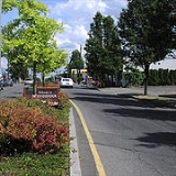
Business and civic activity is concentrated in Woodstock's Village Center located on SE Woodstock Blvd. between SE 39th and SE 52nd Avenues. Churches, a library, and a community center are interspersed with large and small commercial establishments offering a wide range of consumer goods and services. Single and multi-unit residential surround the Village Center with most multi-unit dwellings located near SE Woodstock Blvd. Three schools — Woodstock Elementary School, Lewis Elementary School, and Our Lady of Sorrows Elementary School — are within easy walking distance of the Village Center. Reed College is down the hill to the west, two blocks away.
Portland, Oregon
Portland is a city located in the Pacific Northwest, near the confluence of the Willamette and Columbia rivers in the U.S. state of Oregon. As of the 2010 Census, it had a population of 583,776, making it the 29th most populous city in the United States...
, United States, is located in the city's inner southeast section. It is bounded on the north by SE Holgate Boulevard, west by Cesar Chavez Boulevard (formerly SE 39th Avenue), east by SE 60th and SE 45th, and south by Johnson Creek. Woodstock borders the neighborhoods of Reed
Reed, Portland, Oregon
The Reed neighborhood of Portland, Oregon is in the southeast section of the city, just north of the campus of Reed College.The neighborhood is bounded on the west by railroad tracks, on the north by SE Holgate Ave., on the east by SE 39th Ave., and on the south by SE Reedway, SE Steele, and a...
and Eastmoreland
Eastmoreland, Portland, Oregon
Eastmoreland is an early-twentieth century, tree-filled neighborhood in inner southeast Portland, Oregon, United States. The neighborhood is bounded on the north by SE Woodstock Boulevard. The western boundary is a combination of SE 28th Avenue, SE Bybee Boulevard, and SE 27th Avenue...
on the west, Creston-Kenilworth
Creston-Kenilworth, Portland, Oregon
Creston-Kenilworth is a neighborhood in the Southeast section of Portland, Oregon, lying between SE 26th Ave. on the west and SE Foster Rd. on the east, and between SE Powell Blvd. on the north and SE Holgate Blvd. on the south. It is adjacent to the neighborhoods of Brooklyn to the west,...
on the north, Mt. Scott-Arleta
Mt. Scott-Arleta, Portland, Oregon
The Mt. Scott-Arleta neighborhood of Portland, Oregon is located in the city's southeast section. It is bounded on the north by SE Foster Road, west by SE 60th Avenue, east by SE 82nd Avenue, and south by SE Duke. Mt...
and Brentwood-Darlington
Brentwood-Darlington, Portland, Oregon
Brentwood-Darlington is a neighborhood on the southern edge of Portland, Oregon, bordering Woodstock to the west, Mt. Scott-Arleta to the north, and Lents to the east. The county line separating Multnomah County from Clackamas County forms most the neighborhood's southern boundary, though small...
on the east, and Ardenwald-Johnson Creek
Ardenwald-Johnson Creek, Portland, Oregon
Ardenwald-Johnson Creek is a neighborhood straddling the border between Portland and Milwaukie , Oregon. It is recognized by both Portland's Office of Neighborhood Involvement as well as Milwaukie's Neighborhoods Program.According to Oregon Geographic Names, Ardenwald was named in 1888 for Arden M...
on the south.
It is one of the city’s older neighborhoods, first plat
Plat
A plat in the U.S. is a map, drawn to scale, showing the divisions of a piece of land. Other English-speaking countries generally call such documents a cadastral map or plan....
ted in 1889. The northern portion of the neighborhood contains the majority of the neighborhood’s older homes, some built as early as the 1880s. Post World War II
World War II
World War II, or the Second World War , was a global conflict lasting from 1939 to 1945, involving most of the world's nations—including all of the great powers—eventually forming two opposing military alliances: the Allies and the Axis...
housing construction is concentrated in the southern panhandle and the northeast corner of the neighborhood. More recent urban infill
Infill
Infill in its broadest meaning is material that fills in an otherwise unoccupied space. The term is commonly used in association with construction techniques such as wattle and daub, and civil engineering activities such as land reclamation.-Construction:...
housing is scattered throughout the area although more concentrated in the eastern portion of the area.
Clinton Kelly (minister)
Reverend Clinton Kelly was an early pioneer of what became the U.S. state of Oregon.Kelly was born on June 15, 1808, in Pulaski County, Kentucky, the son of Samuel and Nancy Kelly....
, his wife Mary, their children and extended family members arrived from Kentucky
Kentucky
The Commonwealth of Kentucky is a state located in the East Central United States of America. As classified by the United States Census Bureau, Kentucky is a Southern state, more specifically in the East South Central region. Kentucky is one of four U.S. states constituted as a commonwealth...
. The threat of a civil war and the prospects of free land in the west has prompted Kelly and his brothers and their families to migrate to Oregon
Oregon
Oregon is a state in the Pacific Northwest region of the United States. It is located on the Pacific coast, with Washington to the north, California to the south, Nevada on the southeast and Idaho to the east. The Columbia and Snake rivers delineate much of Oregon's northern and eastern...
.
The first order of business for all of the Kellys was to locate land suitable for farming. Archon Kelly, the third son of Clinton Kelly was 17 years old when he crossed the plains with his family. He filed for his land claim in December 1852 when he was 21. Being unmarried at the time, he was entitled to only 320 acres (1.3 km²). The plateau of wilderness, overlooking an equally underdeveloped, fir-studded area, now the site of Reed College
Reed College
Reed College is a private, independent, liberal arts college located in southeast Portland, Oregon. Founded in 1908, Reed is a residential college with a campus located in Portland's Eastmoreland neighborhood, featuring architecture based on the Tudor-Gothic style, and a forested canyon wilderness...
and Eastmoreland, was five miles (eight km) by wagon road from the main business section of Portland. Using present-day street names, the southern boundary of the granted land parcel was Duke Street from SE 42nd to SE 52nd Avenues and the northern boundary was Raymond between SE 42nd and SE 52nd Avenues. Archon lived on the farm until January 1863 when he sold it to his father for $2,500.
The land subsequently changed hands several more times until it was platted for residential development in 1889. Five men bought 194.5 acre (0.78711427 km²) for $48,000 and named the subdivision Woodstock. Since many residential districts were being formed and people were running out of family names, it had become en vogue to use names from Sir Walter Scott's romantic novels. Woodstock
Woodstock (novel)
Woodstock, or The Cavalier. A Tale of the Year Sixteen Hundred and Fifty-one is a historical novel by Walter Scott. Set just after the English Civil War, it was inspired by the legend of the Good Devil of Woodstock, which in 1649 supposedly tormented parliamentary commissioners who had taken...
is one of the several names from Scott's writings used for naming subdivisions in southeast Portland.
In 1893, James Havely, who acted as trustee for the group who had bought the Woodstock plat, built one of the first houses here; a Queen Anne
Queen Anne Style architecture
The Queen Anne Style in Britain means either the English Baroque architectural style roughly of the reign of Queen Anne , or a revived form that was popular in the last quarter of the 19th century and the early decades of the 20th century...
residence that is now a historic landmark is located at 5450 SE 40th Avenue. He also arranged to have the neighborhood supplied with electricity and water.
Business and civic activity is concentrated in Woodstock's Village Center located on SE Woodstock Blvd. between SE 39th and SE 52nd Avenues. Churches, a library, and a community center are interspersed with large and small commercial establishments offering a wide range of consumer goods and services. Single and multi-unit residential surround the Village Center with most multi-unit dwellings located near SE Woodstock Blvd. Three schools — Woodstock Elementary School, Lewis Elementary School, and Our Lady of Sorrows Elementary School — are within easy walking distance of the Village Center. Reed College is down the hill to the west, two blocks away.