

Alameda Ridge
Encyclopedia
Portland, Oregon
Portland is a city located in the Pacific Northwest, near the confluence of the Willamette and Columbia rivers in the U.S. state of Oregon. As of the 2010 Census, it had a population of 583,776, making it the 29th most populous city in the United States...
, Oregon
Oregon
Oregon is a state in the Pacific Northwest region of the United States. It is located on the Pacific coast, with Washington to the north, California to the south, Nevada on the southeast and Idaho to the east. The Columbia and Snake rivers delineate much of Oregon's northern and eastern...
, United States
United States
The United States of America is a federal constitutional republic comprising fifty states and a federal district...
.
Geologic history
Alameda Ridge was formed between 15,000 and 13,000 years ago at the end of the last ice ageIce age
An ice age or, more precisely, glacial age, is a generic geological period of long-term reduction in the temperature of the Earth's surface and atmosphere, resulting in the presence or expansion of continental ice sheets, polar ice sheets and alpine glaciers...
when the ice dam containing Glacial Lake Missoula
Glacial Lake Missoula
Glacial Lake Missoula was a prehistoric proglacial lake in western Montana that existed periodically at the end of the last ice age between 15,000 and 13,000 years ago...
collapsed some 40 times, causing some of the largest floods known on earth. The flood waters spilled across Idaho
Idaho
Idaho is a state in the Rocky Mountain area of the United States. The state's largest city and capital is Boise. Residents are called "Idahoans". Idaho was admitted to the Union on July 3, 1890, as the 43rd state....
and eastern Washington, surged down the Columbia River
Columbia River
The Columbia River is the largest river in the Pacific Northwest region of North America. The river rises in the Rocky Mountains of British Columbia, Canada, flows northwest and then south into the U.S. state of Washington, then turns west to form most of the border between Washington and the state...
and through the Gorge
Columbia River Gorge
The Columbia River Gorge is a canyon of the Columbia River in the Pacific Northwest of the United States. Up to deep, the canyon stretches for over as the river winds westward through the Cascade Range forming the boundary between the State of Washington to the north and Oregon to the south...
, flooding the Willamette Valley
Willamette Valley
The Willamette Valley is the most populated region in the state of Oregon of the United States. Located in the state's northwest, the region is surrounded by tall mountain ranges to the east, west and south and the valley's floor is broad, flat and fertile because of Ice Age conditions...
as far south as Eugene, Oregon
Eugene, Oregon
Eugene is the second largest city in the U.S. state of Oregon and the seat of Lane County. It is located at the south end of the Willamette Valley, at the confluence of the McKenzie and Willamette rivers, about east of the Oregon Coast.As of the 2010 U.S...
. These floods covered the city of Portland, Oregon
Portland, Oregon
Portland is a city located in the Pacific Northwest, near the confluence of the Willamette and Columbia rivers in the U.S. state of Oregon. As of the 2010 Census, it had a population of 583,776, making it the 29th most populous city in the United States...
in approximately 400 feet (121.9 m) of water, carving out Sullivan's Gulch, the large ravine
Ravine
A ravine is a landform narrower than a canyon and is often the product of streamcutting erosion. Ravines are typically classified as larger in scale than gullies, although smaller than valleys. A ravine is generally a fluvial slope landform of relatively steep sides, on the order of twenty to...
that holds Interstate 84
Interstate 84 in Oregon
In the U.S. state of Oregon, Interstate 84 travels east–west, following the Columbia River and the rough path of the old Oregon Trail from Portland east to Idaho. For this reason, it is also known as most of the Columbia River Highway No. 2 and all of the Old Oregon Trail Highway No. 6 . It...
, and depositing a large volumes of unconsolidated silt, sand, gravel, and boulders. As the west-flowing waters rushed around Rocky Butte
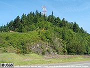
Rocky Butte
Rocky Butte is an extinct volcanic cinder cone butte in Portland, Oregon, United States. It is one of four, along with Kelly Butte, Powell Butte, and Mount Tabor, inside the city that are each home to a city park, Rocky Butte playing host to Joseph Wood Hill Park. It is also part of the Boring...
, a volcanic cinder cone
Volcanic cone
Volcanic cones are among the simplest volcanic formations. They are built by ejecta from a volcanic vent, piling up around the vent in the shape of a cone with a central crater. Volcanic cones are of different types, depending upon the nature and size of the fragments ejected during the eruption...
in the Boring Lava Field
Boring Lava Field
The Boring Lava Field is an extinct Plio-Pleistocene volcanic field zone with at least 32 cinder cones and small shield volcanoes lying within a radius of 13 miles of Kelly Butte, which is approximately 4 miles east of downtown Portland, Oregon, in the United States...
, sediments were deposited on the west side of the butte forming an approximately 100 to 150 feet (45.7 m) high bar that became Alameda Ridge. The ridge extends west roughly 6 miles (9.7 km) from Rocky Butte to approximately 15th Avenue and Skidmore Street.
Human history
Madison South, Portland, Oregon
Madison South is a neighborhood in the Northeast section of Portland, Oregon. It is bordered by the Roseway, Sumner, Cully, Parkrose, Montavilla, and Rose City Park neighborhoods, and by the enclave city of Maywood Park...
, Rose City Park
Rose City Park, Portland, Oregon
Rose City Park is a neighborhood in Northeast Portland, Oregon. It borders Beaumont-Wilshire and the Hollywood District on the west, Cully on the north, Roseway and Madison South on the east, and Center on the south....
, Beaumont-Wilshire
Beaumont-Wilshire, Portland, Oregon
The Beaumont-Wilshire neighborhood of Portland, Oregon is located in the city's northeast section, on Alameda Ridge with views of Downtown, the Willamette River, and the Cascades. It is bordered by the Alameda, Concordia, Cully, Rose City Park, and Grant Park neighborhoods. "Beaumont Village",...
, Alameda
Alameda, Portland, Oregon
Alameda is a neighborhood in Portland, Oregon, United States that is located on the Alameda Ridge with views of Downtown, the Willamette River, and the Cascades. Northeast Fremont Street is the neighborhood’s main east-west thoroughfare and NE 33rd, its main north-south thoroughfare, makes up its...
, and Sabin
Sabin, Portland, Oregon
Sabin is a neighborhood in the Northeast section of Portland, Oregon, United States. It is bordered by Vernon on the north, King on the west, Irvington on the south, Alameda on the east, and Concordia on the northeast.- External links :...
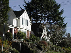
Neighborhoods, with some of the most expensive homes (some being worth more than one million dollars) located along the upper edge of the southern slope in the Rose City Park
Rose City Park, Portland, Oregon
Rose City Park is a neighborhood in Northeast Portland, Oregon. It borders Beaumont-Wilshire and the Hollywood District on the west, Cully on the north, Roseway and Madison South on the east, and Center on the south....
, Beaumont
Beaumont-Wilshire, Portland, Oregon
The Beaumont-Wilshire neighborhood of Portland, Oregon is located in the city's northeast section, on Alameda Ridge with views of Downtown, the Willamette River, and the Cascades. It is bordered by the Alameda, Concordia, Cully, Rose City Park, and Grant Park neighborhoods. "Beaumont Village",...
, Alameda
Alameda, Portland, Oregon
Alameda is a neighborhood in Portland, Oregon, United States that is located on the Alameda Ridge with views of Downtown, the Willamette River, and the Cascades. Northeast Fremont Street is the neighborhood’s main east-west thoroughfare and NE 33rd, its main north-south thoroughfare, makes up its...
Neighborhoods.
External links
- Portland Neighborhood Map
- Northeast Neighborhoods - Portland Connected