

Multnomah Village
Encyclopedia
Portland, Oregon
Portland is a city located in the Pacific Northwest, near the confluence of the Willamette and Columbia rivers in the U.S. state of Oregon. As of the 2010 Census, it had a population of 583,776, making it the 29th most populous city in the United States...
, centered around the Multnomah Village business district. The community developed in the 1910s around a depot of the Oregon Electric Railway
Oregon Electric Railway
The Oregon Electric Railway was an interurban railroad line in the U.S. state of Oregon that linked Portland to Eugene. Service from Portland to Salem, Oregon, began in 1907. The Spokane, Portland and Seattle Railway purchased the system in 1910, and extended service to Eugene in 1912...
of the same name. It was annexed by the city of Portland on November 7, 1950.
Multnomah lies between SW 45th Ave. in the west, SW Capitol Hill Rd. in the east, SW Vermont St. in the north, and I-5
Interstate 5
Interstate 5 is the main Interstate Highway on the West Coast of the United States, running largely parallel to the Pacific Ocean coastline from Canada to Mexico . It serves some of the largest cities on the U.S...
in the south. Exceptions are the area north of SW Nevada Ct. and east of SW 26th Ave. (part of Hillsdale
Hillsdale, Portland, Oregon
The Hillsdale district is a neighborhood in the southwest section of Portland, Oregon, United States. It is centered around the Hillsdale retail and business area, a series of strip malls on SW Capitol Highway between SW Sunset Boulevard and SW Bertha Boulevard...
), an area south of SW Multnomah Blvd. and north of SW Dolph St. where SW 48th Ave. is the western border, and an area south of SW Marigold St. where SW Capitol Highway is the western border. The neighborhood is bordered by Maplewood
Maplewood, Portland, Oregon
Maplewood is a suburban neighborhood in Southwest Portland, Oregon, United States.-Location:Maplewood is on Portland's western border with Garden Home, and on Multnomah County's western border with Washington County. The neighborhood is defined as the area west of SW 45th Ave...
, Ashcreek
Ashcreek, Portland, Oregon
Ashcreek is a Southwest Portland, Oregon neighborhood. It borders Maplewood to the north, Multnomah and Crestwood to the east, Far Southwest to the south, and the Washington County communities of Garden Home-Whitford and Tigard to the west...
, and Crestwood
Crestwood, Portland, Oregon
Crestwood is a neighborhood in the Southwest section of Portland, Oregon located between SW 45th Ave. and Barbur Blvd., adjacent to Multnomah and Ashcreek. Woods Memorial Natural Area is located here, a swath of urban wilderness visited on occasion by elk....
on the west, Hayhurst
Hayhurst, Portland, Oregon
Hayhurst is a neighborhood in the Southwest section of Portland, Oregon, on the border with Washington County...
and Hillsdale to the north, and South Burlingame
South Burlingame, Portland, Oregon
South Burlingame is a neighborhood in the Southwest section of Portland, Oregon. It is bordered by Multnomah to the west, Hillsdale and South Portland to the north, River View Cemetery to the east, and Markham, Marshall Park, and Collins View to the south.Interstate 5 cuts through the northern...
, Markham
Markham, Portland, Oregon
Markham is a neighborhood in the Southwest section of Portland, Oregon. Markham is bordered by Multnomah and South Burlingame on the north, Marshall Park on the east, Arnold Creek on the south, and West Portland Park on the west....
, and West Portland Park
West Portland Park, Portland, Oregon
West Portland Park is a neighborhood in the Southwest section of Portland, Oregon. It lies between SW 53rd Ave. in the west and SW 35th Ave. in the east, and I-5 in the north and SW Stephenson St. in the south. West Portland Park is a neighborhood in the Southwest section of Portland, Oregon. It...
to the south and east.
A bit of Portland history played out in the Village on April 7, 1987 when Mayor Bud Clark fired Police Chief Jim Davis while the two were having a breakfast meeting at the Fat City Cafe.
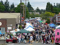
The neighborhood celebrates "Multnomah Days" with a parade
Parade
A parade is a procession of people, usually organized along a street, often in costume, and often accompanied by marching bands, floats or sometimes large balloons. Parades are held for a wide range of reasons, but are usually celebrations of some kind...
and street festival each August.
Multnomah Village was, for a long time, home to the world's first wiki
Wiki
A wiki is a website that allows the creation and editing of any number of interlinked web pages via a web browser using a simplified markup language or a WYSIWYG text editor. Wikis are typically powered by wiki software and are often used collaboratively by multiple users. Examples include...
, WikiWikiWeb
WikiWikiWeb
WikiWikiWeb is a term that has been used to refer to four things: the first wiki, or user-editable website, launched on 25 March 1995 by Ward Cunningham as part of the Portland Pattern Repository ; the Perl-based application that was used to run it, also developed by Cunningham, which was the first...
, which was physically located in an office there. The website has since relocated.
Historic buildings
- The Multnomah School (1913) has since 1979 served as the Multnomah Art Center.
- The Nelson Thomas building (1913) now houses Marco's Cafe.
- The 1925 MasonicFreemasonryFreemasonry is a fraternal organisation that arose from obscure origins in the late 16th to early 17th century. Freemasonry now exists in various forms all over the world, with a membership estimated at around six million, including approximately 150,000 under the jurisdictions of the Grand Lodge...
Lodge (Orenomah Chapter No. 141) is now the Lucky Labrador Public House.
Parks
- Gabriel ParkGabriel ParkGabriel Park is a public park in Portland, Oregon, United States. It features a baseball field, softball field, soccer field, basketball courts, tennis courts, skatepark, volleyball courts, disabled access play area, disabled access restrooms, dog off-leash area, paved and unpaved paths,...
(1950) - Custer Park (1954), named for Gen. George Armstrong CusterGeorge Armstrong CusterGeorge Armstrong Custer was a United States Army officer and cavalry commander in the American Civil War and the Indian Wars. Raised in Michigan and Ohio, Custer was admitted to West Point in 1858, where he graduated last in his class...