

Polar ice packs
Encyclopedia

Sea ice
Sea ice is largely formed from seawater that freezes. Because the oceans consist of saltwater, this occurs below the freezing point of pure water, at about -1.8 °C ....
formed from seawater
Seawater
Seawater is water from a sea or ocean. On average, seawater in the world's oceans has a salinity of about 3.5% . This means that every kilogram of seawater has approximately of dissolved salts . The average density of seawater at the ocean surface is 1.025 g/ml...
in the Earth
Earth
Earth is the third planet from the Sun, and the densest and fifth-largest of the eight planets in the Solar System. It is also the largest of the Solar System's four terrestrial planets...
's polar region
Polar region
Earth's polar regions are the areas of the globe surrounding the poles also known as frigid zones. The North Pole and South Pole being the centers, these regions are dominated by the polar ice caps, resting respectively on the Arctic Ocean and the continent of Antarctica...
s, known as polar ice cap
Polar ice cap
A polar ice cap is a high latitude region of a planet or natural satellite that is covered in ice. There are no requirements with respect to size or composition for a body of ice to be termed a polar ice cap, nor any geological requirement for it to be over land; only that it must be a body of...
s: the Arctic ice pack (or Arctic ice cap) of the Arctic Ocean
Arctic Ocean
The Arctic Ocean, located in the Northern Hemisphere and mostly in the Arctic north polar region, is the smallest and shallowest of the world's five major oceanic divisions...
and the Antarctic ice pack of the Southern Ocean
Southern Ocean
The Southern Ocean comprises the southernmost waters of the World Ocean, generally taken to be south of 60°S latitude and encircling Antarctica. It is usually regarded as the fourth-largest of the five principal oceanic divisions...
, fringing the Antarctic ice sheet
Antarctic ice sheet
The Antarctic ice sheet is one of the two polar ice caps of the Earth. It covers about 98% of the Antarctic continent and is the largest single mass of ice on Earth. It covers an area of almost 14 million square km and contains 30 million cubic km of ice...
. Polar packs significantly change their size during seasonal changes of the year. However, underlying this seasonal variation, there is an underlying trend of melting as part of a more general process of Arctic shrinkage
Arctic shrinkage
Ongoing changes in the climate of the Arctic include rising temperatures, loss of sea ice, and melting of the Greenland ice sheet. Projections of sea ice loss suggest that the Arctic ocean will likely be free of summer sea ice sometime between 2060 and 2080, while another estimate puts this date at...
.
In spring and summer, when melting occurs, the margins of the sea ice
Sea ice
Sea ice is largely formed from seawater that freezes. Because the oceans consist of saltwater, this occurs below the freezing point of pure water, at about -1.8 °C ....
retreat. The vast bulk of the world's sea ice forms in the Arctic ocean
Arctic Ocean
The Arctic Ocean, located in the Northern Hemisphere and mostly in the Arctic north polar region, is the smallest and shallowest of the world's five major oceanic divisions...
and the Southern Ocean
Southern Ocean
The Southern Ocean comprises the southernmost waters of the World Ocean, generally taken to be south of 60°S latitude and encircling Antarctica. It is usually regarded as the fourth-largest of the five principal oceanic divisions...
, around Antarctica. The Antarctic ice cover is highly seasonal, with very little ice in the austral summer, expanding to an area roughly equal to that of Antarctica in winter. Consequently, most Antarctic sea ice is first year ice, up to 1 metres (3.28 ft) thick. The situation in the Arctic is very different (a polar sea surrounded by land, as opposed to a polar continent surrounded by sea) and the seasonal variation much less, currently 28% of Arctic basin sea ice is multi-year ice, thicker than seasonal: up to 3–4 m (9.8–13.1 ft) thick over large areas, with ridges up to 20 metres (65.6 ft) thick.
The area of sea ice around the poles in winter is about 15600000 km² (6,023,193.7 sq mi) either for the Antarctic or Arctic. However, whereas the northern cap is shrinking at a rate of about 3% per decade, the southern cap is expanding at a rate of 1.8% per decade. The amount melted each summer is affected by the different environments: the cold Antarctic pole is over land, which is bordered by sea ice in the freely circulating Southern Ocean. The summer icer cover is about 12% of the winter coverage in the Antarctic and 50% in the Arctic.
Methane restraint
Methane
Methane is a chemical compound with the chemical formula . It is the simplest alkane, the principal component of natural gas, and probably the most abundant organic compound on earth. The relative abundance of methane makes it an attractive fuel...
in permafrost
Permafrost
In geology, permafrost, cryotic soil or permafrost soil is soil at or below the freezing point of water for two or more years. Ice is not always present, as may be in the case of nonporous bedrock, but it frequently occurs and it may be in amounts exceeding the potential hydraulic saturation of...
and in clathrates. Arctic methane release
Arctic methane release
Arctic methane release is the release of methane from seas and soils in permafrost regions of the Arctic, as part of a more general release of carbon from these soils and seas. Whilst a long-term natural process, it may be exacerbated by global warming. This results in a weak positive feedback...
triggered by a breakdown in sea ice could cause an abrupt climate change
Climate change
Climate change is a significant and lasting change in the statistical distribution of weather patterns over periods ranging from decades to millions of years. It may be a change in average weather conditions or the distribution of events around that average...
event, potentially similar in some ways to the Paleocene-Eocene thermal maximum
Paleocene-Eocene Thermal Maximum
The most extreme change in Earth surface conditions during the Cenozoic Era began at the temporal boundary between the Paleocene and Eocene epochs . This event, the Paleocene–Eocene Thermal Maximum , was associated with rapid global...
event, or to the great dying, a mass extinction event.
Albedo effects
Sea ice has an important effect on the heat balance of the polar oceans, since it insulates the (relatively) warm ocean from the much colder air above, thus reducing heat loss from the oceans. Sea ice has a high albedoAlbedo
Albedo , or reflection coefficient, is the diffuse reflectivity or reflecting power of a surface. It is defined as the ratio of reflected radiation from the surface to incident radiation upon it...
— about 0.6 when bare, and about 0.8 when covered with snow — compared to the sea – about 0.15 – and thus the ice also affects the absorption of sunlight at the surface. The sea ice cycle is also an important source of dense (saline) "bottom water
Bottom water
Bottom water is the lowermost water mass in a water body, by its bottom, with distinct characteristics, in terms of physics, chemistry, and ecology.-Oceanology:In oceanology, bottom water is by the ocean floor...
". While freezing, water rejects its salt content (leaving pure ice). The remaining surface water, made dense by the extra salinity, sinks, leading to the productions of dense water mass
Water mass
An oceanographic water mass is an identifiable body of water with a common formation history which has physical properties distinct from surrounding water...
es such as Antarctic Bottom Water
Antarctic Bottom Water
The 'Antarctic Bottom Water' is a type of water mass in the seas surrounding Antarctica with temperatures ranging from 0 to -0.8◦ C, salinities from 34.6 to 34.7 psu, and a density near 27.88...
. This production of dense water is a factor in maintaining the thermohaline circulation
Thermohaline circulation
The term thermohaline circulation refers to a part of the large-scale ocean circulation that is driven by global density gradients created by surface heat and freshwater fluxes....
, and the accurate representation of these processes is an additional difficulty to climate model
Climate model
Climate models use quantitative methods to simulate the interactions of the atmosphere, oceans, land surface, and ice. They are used for a variety of purposes from study of the dynamics of the climate system to projections of future climate...
ling.
Hydrological effects
In the Arctic, a key area where pancake ice forms the dominant ice type over an entire region is the so-called Odden ice tongue in the Greenland SeaGreenland Sea
The Greenland Sea is a body of water that borders Greenland to the west, the Svalbard archipelago to the east, Fram Strait and the Arctic Ocean to the north, and the Norwegian Sea and Iceland to the south. The Greenland Sea is often defined as part of the Arctic Ocean, sometimes as part of the...
. The Odden (the word is Norwegian
Norwegian language
Norwegian is a North Germanic language spoken primarily in Norway, where it is the official language. Together with Swedish and Danish, Norwegian forms a continuum of more or less mutually intelligible local and regional variants .These Scandinavian languages together with the Faroese language...
for headland) grows eastward from the main East Greenland ice edge in the vicinity of 72–74°N during the winter because of the presence of very cold polar surface water in the Jan Mayen Current, which diverts some water eastward from the East Greenland Current
East Greenland Current
The East Greenland Current is a cold, low salinity current that extends from Fram Strait to Cape Farewell . The current is located off the eastern coast of Greenland along the Greenland continental margin. The current cuts through the Nordic Seas and through the Denmark Strait...
at that latitude. Most of the old ice continues south, driven by the wind, so a cold open water surface is exposed on which new ice forms as frazil and pancake in the rough seas. The salt rejected back into the ocean from this ice formation causes the surface water to become denser and sink, sometimes to great depths (2500 m (8,202.1 ft) or more), making this one of the few regions of the ocean where winter convection occurs, which helps drive the entire worldwide system of surface and deep currents known as the thermohaline circulation.
Extent and volume of sea ice and their trend
Records of Arctic Sea ice from the United Kingdom’s Hadley Centre for Climate Prediction and Research go back to the turn of the 20th century, although the quality of the data before 1950 is debatable. Still, these records show a persistent decline in Arctic Sea ice over the last 50 years.Reliable measurements of sea ice
Measurement of sea ice
Measurement of sea ice is important for safety of navigation and for monitoring the environment, particularly the climate. Record keeping of direct observations began over a thousand years ago, but was sparse until the 1950s. Truly comprehensive records began with the satellite era in the late 1970s...
edge begin within the satellite era. From the late 1970s, the Scanning Multichannel Microwave Radiometer
Scanning Multichannel Microwave Radiometer
The scanning multichannel microwave radiometer [pronounced simmer] was a five-frequency microwave radiometer flown on the Seasat and Nimbus 7 satellites. Both were launched in 1978, with the Seasat mission lasting less than six months until failure of the primary bus. The Nimbus 7 SMMR lasted from...
(SMMR) on Seasat
Seasat
SEASAT was the first Earth-orbiting satellite designed for remote sensing of the Earth's oceans and had on board the first spaceborne synthetic aperture radar . The mission was designed to demonstrate the feasibility of global satellite monitoring of oceanographic phenomena and to help determine...
(1978) and Nimbus 7 (1978–87) satellites provided information that was independent of solar illumination or meteorological conditions. The frequency and accuracy of passive microwave measurements improved with the launch of the DMSP F8 Special Sensor Microwave/Imager SSMI in 1987. Both the sea ice area and extent are estimated, with the latter being larger, as it is defined as the area of ocean with at least 15% sea ice.
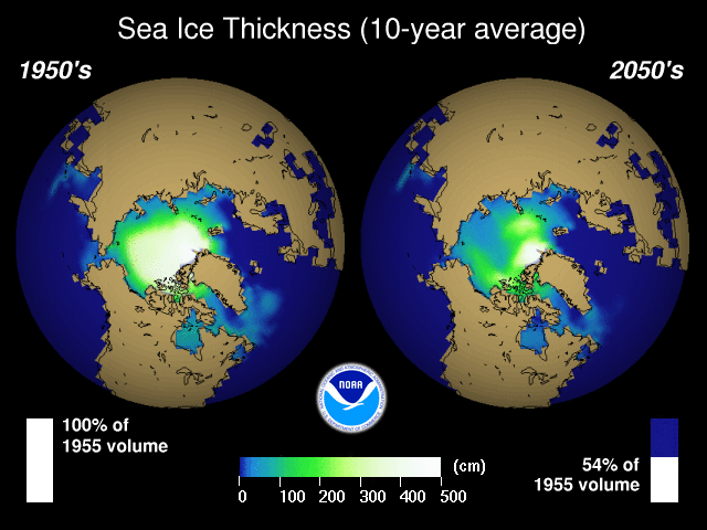
A modeling study of the 52-year period from 1948 to 1999 found a statistically significant trend in Arctic ice volume of −3% per decade; splitting this into wind-forced and temperature forced components shows it to be essentially all caused by the temperature forcing. A computer-based, time-resolved calculation of sea ice volume, fitted to various measurements, revealed that monitoring the ice volume is much more significant for evaluating sea ice loss than pure area considerations.
The trends from 1979 to 2002 have been a statistically significant Arctic decrease and an Antarctic increase that is probably not significant, depending exactly on which time period is used. The Arctic trends of −2.5% ± 0.9% per decade; or about 3% per decade. Climate models simulated this trend in 2002, and attributed it to anthropogenic forcing.
The September ice extent trend for 1979–2004 is declining by 7.7% per decade.
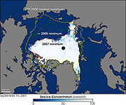
In 2007 the ice melt accelerated. The minimum extent fell by more than a million square kilometers, the biggest decline ever. The minimum extent fell to 4140000 km² (1,598,462.9 sq mi), by far the lowest ever. New research shows the Arctic Sea ice to be melting faster than predicted by any of the 18 computer models used by the Intergovernmental Panel on Climate Change in preparing its 2007 assessments.
While the Northern Hemisphere sea ice reached new record lows, on September 12, 2007 the Southern Hemisphere sea ice area reached 15910000 km² (6,142,885.3 sq mi), close to the maximum recorded of 16020000 km² (6,185,356.6 sq mi).
The Antarctic increase is 0.8% per decade although this depends on the period being considered. Vinnikov et al. find the NH reduction to be statistically significant but the SH trend is not.
In the overall mass balance, the volume of sea ice depends on the thickness of the ice as well as the areal extent. While the satellite era has enabled better measurement of trends in areal extent, accurate ice thickness measurements remain a challenge. "Nonetheless, the extreme loss of this summer’s sea ice cover and the slow onset of freeze-up portends lower than normal ice extent throughout autumn and winter, and the ice that grows back is likely to be fairly thin".
2007 record low Arctic sea ice
North Pole
The North Pole, also known as the Geographic North Pole or Terrestrial North Pole, is, subject to the caveats explained below, defined as the point in the northern hemisphere where the Earth's axis of rotation meets its surface...
. A 2007 NASA
NASA
The National Aeronautics and Space Administration is the agency of the United States government that is responsible for the nation's civilian space program and for aeronautics and aerospace research...
study concluded that the shrinkage was the result of "unusual atmospheric conditions [which] set up wind patterns that compressed the sea ice, loaded it into the Transpolar Drift Stream and then sped its flow out of the Arctic." Also the total summertime cloud cover was lower than previous years enhancing the melting.
The NSIDC also reported that, for the first time in recorded history, the Northwest Passage
Northwest Passage
The Northwest Passage is a sea route through the Arctic Ocean, along the northern coast of North America via waterways amidst the Canadian Arctic Archipelago, connecting the Atlantic and Pacific Oceans...
opened to ships without the need of icebreakers. The main channel of this passage (Lancaster Sound
Lancaster Sound
Lancaster Sound is a body of water in Qikiqtaaluk, Nunavut, Canada. It is located between Devon Island and Baffin Island, forming the eastern portion of the Northwest Passage. East of the sound lies Baffin Bay; to the west lies Viscount Melville Sound...
to M'Clure Strait) opened as early as August 11. However, the Northeast Passage remained blocked by a narrow band of sea ice around Severnaya Zemlya
Severnaya Zemlya
Severnaya Zemlya is an archipelago in the Russian high Arctic at around . It is located off mainland Siberia's Taymyr Peninsula across the Vilkitsky Strait...
.
Winter 2007/2008 Arctic ice growth
Environment Canada
Environment Canada , legally incorporated as the Department of the Environment under the Department of the Environment Act Environment Canada (EC) (French: Environnement Canada), legally incorporated as the Department of the Environment under the Department of the Environment Act Environment...
in Ottawa.
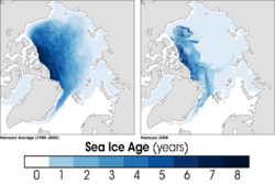
While the cold winter did allow sea ice to re-cover much of the Arctic during the Winter of 2007/2008, conditions were far from normal as "this" pair of NASA images (in the cited reference) reveals. The February 2008 ice pack (right) contained much more young ice than the long-term average (left). In the past, more ice survived the summer melt season and had the chance to thicken over the following winter. In the mid- to late 1980s, over 20 percent of Arctic sea ice was at least six years old; in February 2008, just 6 percent of the ice was six years old or older.
Summer 2008 Arctic ice shrinking
The 2008 minimum was slightly larger than 2007. On August 27, both the Northwest Passage and the Northeast Passage were ice-free. This was the first time in recorded history that both passages were open at the same time. The North PoleNorth Pole
The North Pole, also known as the Geographic North Pole or Terrestrial North Pole, is, subject to the caveats explained below, defined as the point in the northern hemisphere where the Earth's axis of rotation meets its surface...
could at that point have been circumnavigated., although the icebreaker Polarstern
PFS Polarstern
RV Polarstern is a German research icebreaker of the Alfred Wegener Institute for Polar and Marine Research in Bremerhaven. The Polarstern was commissioned in 1982 and is mainly used for research in the Arctic and Antarctica....
was the only ship to actually make the circumnavigation. The Beluga Group of Bremen
Bremen
The City Municipality of Bremen is a Hanseatic city in northwestern Germany. A commercial and industrial city with a major port on the river Weser, Bremen is part of the Bremen-Oldenburg metropolitan area . Bremen is the second most populous city in North Germany and tenth in Germany.Bremen is...
, Germany
Germany
Germany , officially the Federal Republic of Germany , is a federal parliamentary republic in Europe. The country consists of 16 states while the capital and largest city is Berlin. Germany covers an area of 357,021 km2 and has a largely temperate seasonal climate...
, announced plans to send the first ship through the Northern Sea Route
Northern Sea Route
The Northern Sea Route is a shipping lane officially defined by Russian legislation from the Atlantic Ocean to the Pacific Ocean specifically running along the Russian Arctic coast from Murmansk on the Barents Sea, along Siberia, to the Bering Strait and Far East. The entire route lies in Arctic...
in 2009, thereby cutting 4000 nmi (7,408 km; 4,603.1 mi) off the voyage from Germany to Japan.
Summer 2009 Arctic ice shrinking
The significant reduction in the extent of the summer sea ice cover and the decrease in the amount of relatively older, thicker ice continued in 2009. The extent of the 2009 summer sea ice cover was the fourth lowest value of the satellite monitoring record and more than 25% below the 1979–2000 average.Despite the fact that the extent did not reach a new minimum in 2009 due to unfavorable wind conditions in August, it did set a new record for minimum ice volume.
Summer 2010 Arctic ice shrinking
On September 19, 2010, 10 days later than the usual minimum, the arctic ice cover reached 4600000 km² (1,776,069.9 sq mi), its third lowest value since satellite monitoring began. The 2010 minimum was just 37000 km² (14,285.8 sq mi) above that of 2008, and 2110000 km² (814,675.6 sq mi) below the 1979 to 2009 average minimum. For the first time, two yachts were able to make the circumnavigation in one season: The Russian "Peter 1" with captain Daniel Gavrilov arriving first, and the Norwegian "Northern Passage" with captain Børge OuslandBørge Ousland
Børge Ousland is a Norwegian polar explorer, photographer and writer. He made the first unassisted Antarctic solo crossing, finishing on 18 January 1997. He ventured to the South Pole on 8 December 2005...
.
See also
- Arctic OceanArctic OceanThe Arctic Ocean, located in the Northern Hemisphere and mostly in the Arctic north polar region, is the smallest and shallowest of the world's five major oceanic divisions...
- Arctic shrinkageArctic shrinkageOngoing changes in the climate of the Arctic include rising temperatures, loss of sea ice, and melting of the Greenland ice sheet. Projections of sea ice loss suggest that the Arctic ocean will likely be free of summer sea ice sometime between 2060 and 2080, while another estimate puts this date at...
- Extreme Ice SurveyExtreme Ice SurveyThe Extreme Ice Survey documents rapid changes on glaciers across the Northern Hemisphere. It is the most wide-ranging glacier study ever conducted using ground-based, real-time photography. The Extreme Ice Survey uses time-lapse photography, conventional photography and video to illustrate the...
- Global warmingGlobal warmingGlobal warming refers to the rising average temperature of Earth's atmosphere and oceans and its projected continuation. In the last 100 years, Earth's average surface temperature increased by about with about two thirds of the increase occurring over just the last three decades...
- IcebergIcebergAn iceberg is a large piece of ice from freshwater that has broken off from a snow-formed glacier or ice shelf and is floating in open water. It may subsequently become frozen into pack ice...
- Ice driftIce driftIce drift is movement of ice. An important type of ice drift is drift of the sea ice, i.e., of the drift ice. Unless specified otherwise, this article discusses the drift of the sea ice. The direction of the ice drift is the vector sum of the oceanic and atmospheric circulations, i.e., upper ocean...
- JurassicJurassicThe Jurassic is a geologic period and system that extends from about Mya to Mya, that is, from the end of the Triassic to the beginning of the Cretaceous. The Jurassic constitutes the middle period of the Mesozoic era, also known as the age of reptiles. The start of the period is marked by...
- Marine Modeling and Analysis BranchMarine Modeling and Analysis BranchThe United States Marine Modeling and Analysis Branch is part of the Environmental Modeling Center, which is responsible for the development of improved numerical weather and marine prediction modeling systems within NCEP/NWS...
- Polar ice capPolar ice capA polar ice cap is a high latitude region of a planet or natural satellite that is covered in ice. There are no requirements with respect to size or composition for a body of ice to be termed a polar ice cap, nor any geological requirement for it to be over land; only that it must be a body of...
- PolynyaPolynyaA polynya or polynia is an area of open water surrounded by sea ice. It is now used as geographical term for an area of unfrozen sea within the ice pack. It is a loanword from , , which means a natural ice hole, and was adopted in the 19th century by polar explorers to describe navigable...
- Sea iceSea iceSea ice is largely formed from seawater that freezes. Because the oceans consist of saltwater, this occurs below the freezing point of pure water, at about -1.8 °C ....
- Shelf iceShelf iceShelf ice can refer to the ice that forms when a portion of a lake surface freezes. It is often then washed upon the shore. This is common within the Great Lakes.-Formation:...
- Tabular iceberg
- TriassicTriassicThe Triassic is a geologic period and system that extends from about 250 to 200 Mya . As the first period of the Mesozoic Era, the Triassic follows the Permian and is followed by the Jurassic. Both the start and end of the Triassic are marked by major extinction events...
External links
- Ice in the Sea, chapter from Nathaniel BowditchNathaniel BowditchNathaniel Bowditch was an early American mathematician remembered for his work on ocean navigation. He is often credited as the founder of modern maritime navigation; his book The New American Practical Navigator, first published in 1802, is still carried on board every commissioned U.S...
's American Practical Navigator. - Cryosphere Today: current Arctic sea ice conditions.
- The Shrinking Arctic Ice Cap research summary, graphics and animations from NOAA Geophysical Fluid Dynamics LaboratoryGeophysical Fluid Dynamics LaboratoryThe Geophysical Fluid Dynamics Laboratory is a laboratory in the National Oceanic and Atmospheric Administration /Office of Oceanic and Atmospheric Research . The current director is Dr. V...
- Data source for sea ice picture.
- Everything you ever wanted to know about sea ice but were afraid to ask.
- Animation of the movement of sea ice, September 2003 through May 2004.
- NSIDC Sea Ice Index.
- Arctic summer time: The short summer of 2004. North Pole webcam view.
- Global Sea Ice Extent and Concentration: what sensors on satellites are telling us about sea ice.
- "Arctic ice 'disappearing quickly'", BBC News, 28 September 2005.
- "Ice-free Arctic could be here in 23 years" David Adam, environment correspondent, The Guardian, September 5, 2007, Retrieved September 5, 2007
- "Arctic Melt Unnerves the Experts" Andrew C. Revkin, The New York Times, October 2, 2007, Retrieved October 2, 2007.
- Video on polar ice changes around St. Lawrence Island in the Bering Sea
- The Arctic ice sheet True color map, daily updates during summer.