
Climate model
Encyclopedia
Earth's atmosphere
The atmosphere of Earth is a layer of gases surrounding the planet Earth that is retained by Earth's gravity. The atmosphere protects life on Earth by absorbing ultraviolet solar radiation, warming the surface through heat retention , and reducing temperature extremes between day and night...
, ocean
Ocean
An ocean is a major body of saline water, and a principal component of the hydrosphere. Approximately 71% of the Earth's surface is covered by ocean, a continuous body of water that is customarily divided into several principal oceans and smaller seas.More than half of this area is over 3,000...
s, land surface, and ice
Cryosphere
The cryosphere is the term which collectively describes the portions of the Earth’s surface where water is in solid form, including sea ice, lake ice, river ice, snow cover, glaciers, ice caps and ice sheets, and frozen ground . Thus there is a wide overlap with the hydrosphere...
. They are used for a variety of purposes from study of the dynamics of the climate system to projections of future climate
Climate
Climate encompasses the statistics of temperature, humidity, atmospheric pressure, wind, rainfall, atmospheric particle count and other meteorological elemental measurements in a given region over long periods...
. The most talked-about use of climate models in recent years has been to project temperature changes resulting from increases in atmospheric concentrations of greenhouse gases.
All climate models take account of incoming energy
Energy
In physics, energy is an indirectly observed quantity. It is often understood as the ability a physical system has to do work on other physical systems...
from the sun as short wave electromagnetic radiation
Electromagnetic radiation
Electromagnetic radiation is a form of energy that exhibits wave-like behavior as it travels through space...
, chiefly visible
Visible spectrum
The visible spectrum is the portion of the electromagnetic spectrum that is visible to the human eye. Electromagnetic radiation in this range of wavelengths is called visible light or simply light. A typical human eye will respond to wavelengths from about 390 to 750 nm. In terms of...
and short-wave (near) infrared
Infrared
Infrared light is electromagnetic radiation with a wavelength longer than that of visible light, measured from the nominal edge of visible red light at 0.74 micrometres , and extending conventionally to 300 µm...
, as well as outgoing energy as long wave (far) infrared
Infrared
Infrared light is electromagnetic radiation with a wavelength longer than that of visible light, measured from the nominal edge of visible red light at 0.74 micrometres , and extending conventionally to 300 µm...
electromagnetic radiation from the earth. Any imbalance results in a change in temperature
First law of thermodynamics
The first law of thermodynamics is an expression of the principle of conservation of work.The law states that energy can be transformed, i.e. changed from one form to another, but cannot be created nor destroyed...
.
Models can range from relatively simple to quite complex:
- A simple radiant heat transfer model that treats the earth as a single point and averages outgoing energy
- this can be expanded vertically (radiative-convective models), or horizontally
- finally, (coupled) atmosphere–ocean–sea iceSea iceSea ice is largely formed from seawater that freezes. Because the oceans consist of saltwater, this occurs below the freezing point of pure water, at about -1.8 °C ....
global climate modelGlobal climate modelA General Circulation Model is a mathematical model of the general circulation of a planetary atmosphere or ocean and based on the Navier–Stokes equations on a rotating sphere with thermodynamic terms for various energy sources . These equations are the basis for complex computer programs commonly...
s discretise and solve the full equations for mass and energy transfer and radiant exchange.
This is not a full list; for example "box models" can be written to treat flows across and within ocean basins. Furthermore, other types of modelling can be interlinked, such as land use
Land use
Land use is the human use of land. Land use involves the management and modification of natural environment or wilderness into built environment such as fields, pastures, and settlements. It has also been defined as "the arrangements, activities and inputs people undertake in a certain land cover...
, allowing researchers to predict the interaction between climate and ecosystems.
Box models
Box models are simplified versions of complex systems, reducing them to boxes (or reservoirReservoir
A reservoir , artificial lake or dam is used to store water.Reservoirs may be created in river valleys by the construction of a dam or may be built by excavation in the ground or by conventional construction techniques such as brickwork or cast concrete.The term reservoir may also be used to...
s) linked by fluxes. The boxes are assumed to be mixed homogeneously. Within a given box, the concentration of any chemical species
Chemical species
Chemical species are atoms, molecules, molecular fragments, ions, etc., being subjected to a chemical process or to a measurement. Generally, a chemical species can be defined as an ensemble of chemically identical molecular entities that can explore the same set of molecular energy levels on a...
is therefore uniform. However, the abundance of a species within a given box may vary as a function of time due to the input to (or loss from) the box or due to the production, consumption or decay of this species within the box.
Simple box models, i.e. box model with a small number of boxes whose properties (e.g. their volume) do not change with time, are often useful to derive analytical formulas describing the dynamics and steady-state abundance of a species. More complex box models are usually solved using numerical techniques.
Box models are used extensively to model environmental systems or ecosystems and in studies of ocean circulation and the carbon cycle
Carbon cycle
The carbon cycle is the biogeochemical cycle by which carbon is exchanged among the biosphere, pedosphere, geosphere, hydrosphere, and atmosphere of the Earth...
.
Zero-dimensional models
A very simple model of the radiative equilibrium of the Earth is
where
- the left hand side represents the incoming energy from the Sun
- the right hand side represents the outgoing energy from the Earth, calculated from the Stefan-Boltzmann law assuming a constant radiative temperature, T, that is to be found,
and
- S is the solar constantSolar constantThe solar constant, a measure of flux density, is the amount of incoming solar electromagnetic radiation per unit area that would be incident on a plane perpendicular to the rays, at a distance of one astronomical unit...
– the incoming solar radiation per unit area—about 1367 W·m−2 -
 is the EarthEarthEarth is the third planet from the Sun, and the densest and fifth-largest of the eight planets in the Solar System. It is also the largest of the Solar System's four terrestrial planets...
's average albedoAlbedoAlbedo , or reflection coefficient, is the diffuse reflectivity or reflecting power of a surface. It is defined as the ratio of reflected radiation from the surface to incident radiation upon it...
, measured to be 0.3. - r is Earth's radius—approximately 6.371×10⁶m
- πPi' is a mathematical constant that is the ratio of any circle's circumference to its diameter. is approximately equal to 3.14. Many formulae in mathematics, science, and engineering involve , which makes it one of the most important mathematical constants...
is the mathematical constant (3.141...) -
 is the Stefan-Boltzmann constantStefan-Boltzmann constantThe Stefan–Boltzmann constant , a physical constant denoted by the Greek letter σ, is the constant of proportionality in the Stefan–Boltzmann law: the total energy radiated per unit surface area of a black body in unit time is proportional to the fourth power of the thermodynamic temperature.The...
—approximately 5.67×10⁻⁸ J·K−4·m−2·s−1 -
 is the effective emissivityEmissivityThe emissivity of a material is the relative ability of its surface to emit energy by radiation. It is the ratio of energy radiated by a particular material to energy radiated by a black body at the same temperature...
of earth, about 0.612
The constant πr2 can be factored out, giving

Solving for the temperature,

This yields an average earth temperature of 288 K. This is because the above equation represents the effective radiative temperature of the Earth (including the clouds and atmosphere). The use of effective emissivity and albedo account for the greenhouse effect
Greenhouse effect
The greenhouse effect is a process by which thermal radiation from a planetary surface is absorbed by atmospheric greenhouse gases, and is re-radiated in all directions. Since part of this re-radiation is back towards the surface, energy is transferred to the surface and the lower atmosphere...
.
This very simple model is quite instructive, and the only model that could fit on a page. For example, it easily determines the effect on average earth temperature of changes in solar constant or change of albedo or effective earth emissivity. Using the simple formula, the percent change of the average amount of each parameter, considered independently, to cause a one degree Celsius change in steady-state average earth temperature is as follows:
- Solar constant 1.4%
- Albedo 3.3%
- Effective emissivity 1.4%
The average emissivity of the earth is readily estimated from available data. The emissivities of terrestrial surfaces are all in the range of 0.96 to 0.99 (except for some small desert areas which may be as low as 0.7). Clouds, however, which cover about half of the earth’s surface, have an average emissivity of about 0.5 (which must be reduced by the fourth power of the ratio of cloud absolute temperature to average earth absolute temperature) and an average cloud temperature of about 258 K. Taking all this properly into account results in an effective earth emissivity of about 0.64 (earth average temperature 285 K).
This simple model readily determines the effect of changes in solar output or change of earth albedo or effective earth emissivity on average earth temperature. It says nothing, however about what might cause these things to change. Zero-dimensional models do not address the temperature distribution on the earth or the factors that move energy about the earth.
Radiative-convective models
The zero-dimensional model above, using the solar constant and given average earth temperature, determines the effective earth emissivity of long wave radiation emitted to space. This can be refined in the vertical to a zero-dimensional radiative-convective model, which considers two processes of energy transport:- upwelling and downwelling radiative transfer through atmospheric layers that both absorb and emit infrared radiation
- upward transport of heat by convection (especially important in the lower troposphereTroposphereThe troposphere is the lowest portion of Earth's atmosphere. It contains approximately 80% of the atmosphere's mass and 99% of its water vapor and aerosols....
).
The radiative-convective models have advantages over the simple model: they can determine the effects of varying greenhouse gas
Greenhouse gas
A greenhouse gas is a gas in an atmosphere that absorbs and emits radiation within the thermal infrared range. This process is the fundamental cause of the greenhouse effect. The primary greenhouse gases in the Earth's atmosphere are water vapor, carbon dioxide, methane, nitrous oxide, and ozone...
concentrations on effective emissivity and therefore the surface temperature. But added parameters are needed to determine local emissivity and albedo and address the factors that move energy about the earth.
Effect of ice-albedo feedback on global sensitivity in a one-dimensional radiative-convective climate model.
Higher-dimension models
The zero-dimensional model may be expanded to consider the energy transported horizontally in the atmosphere. This kind of model may well be zonallyZonal and meridional
The terms zonal and meridional are used to describe directions on a globe. Zonal means "along a latitude circle" or "in the west–east direction"; while meridional means "along a meridian" or "in the north–south direction"....
averaged. This model has the advantage of allowing a rational dependence of local albedo and emissivity on temperature – the poles can be allowed to be icy and the equator warm – but the lack of true dynamics means that horizontal transports have to be specified.
EMICs (Earth-system models of intermediate complexity)
Depending on the nature of questions asked and the pertinent time scales, there are, on the one extreme, conceptual, more inductive models, and, on the other extreme, general circulation models operating at the highest spatial and temporal resolution currently feasible. Models of intermediate complexity bridge the gap. One example is the Climber-3 model. Its atmosphere is a 2.5-dimensional statistical-dynamical model with 7.5° × 22.5° resolution and time step of half a day; the ocean is MOM-3 (Modular Ocean ModelModular Ocean Model
The modular ocean model is a three-dimensional ocean circulation model designed primarily for studying the ocean climate system. The model is developed and supported primarily by researchers at the National Oceanic and Atmospheric Administration's Geophysical Fluid Dynamics Laboratory .- Overview...
) with a 3.75° × 3.75° grid and 24 vertical levels.
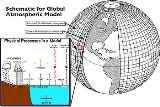
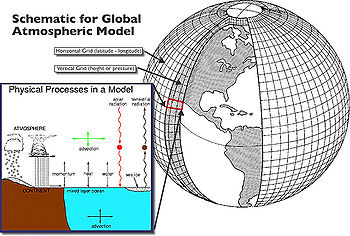
GCMs (global climate models or general circulation models)
Three (or more properly, four since time is also considered) dimensional GCM's discretise the equations for fluid motion and energy transfer and integrate these over time. They also contain parametrisations for processes—such as convection—that occur on scales too small to be resolved directly.Atmospheric GCMs (AGCMs) model the atmosphere and impose sea surface temperature
Sea surface temperature
Sea surface temperature is the water temperature close to the oceans surface. The exact meaning of surface varies according to the measurement method used, but it is between and below the sea surface. Air masses in the Earth's atmosphere are highly modified by sea surface temperatures within a...
s as boundary conditions. Coupled atmosphere-ocean GCMs (AOGCMs, e.g. HadCM3
HadCM3
HadCM3 is a coupled atmosphere-ocean general circulation model developed at the Hadley Centre in the United Kingdom...
, EdGCM
EdGCM
The Educational Global Climate Model or ' is a fully functional global climate model that has been ported for use on desktop computers...
, GFDL CM2.X
GFDL CM2.X
GFDL CM2.X is a coupled atmosphere-ocean general circulation model developed at the NOAA Geophysical Fluid Dynamics Laboratory in the United States...
, ARPEGE-Climat) combine the two models. The first general circulation climate model that combined both oceanic and atmospheric processes was developed in the late 1960s at the NOAA Geophysical Fluid Dynamics Laboratory
Geophysical Fluid Dynamics Laboratory
The Geophysical Fluid Dynamics Laboratory is a laboratory in the National Oceanic and Atmospheric Administration /Office of Oceanic and Atmospheric Research . The current director is Dr. V...
AOGCMs represent the pinnacle of complexity in climate models and internalise as many processes as possible. However, they are still under development and uncertainties remain. They may be coupled to models of other processes, such as the carbon cycle
Carbon cycle
The carbon cycle is the biogeochemical cycle by which carbon is exchanged among the biosphere, pedosphere, geosphere, hydrosphere, and atmosphere of the Earth...
, so as to better model feedback effects.
Most recent simulations show "plausible" agreement with the measured temperature anomalies over the past 150 years when forced by natural forcings
Radiative forcing
In climate science, radiative forcing is generally defined as the change in net irradiance between different layers of the atmosphere. Typically, radiative forcing is quantified at the tropopause in units of watts per square meter. A positive forcing tends to warm the system, while a negative...
alone, but better agreement is achieved when observed changes in greenhouse gases and aerosols are also included.
Research and development
There are three major types of institution where climate models are developed, implemented and used:- National meteorological services. Most national weather services have a climatologyClimatologyClimatology is the study of climate, scientifically defined as weather conditions averaged over a period of time, and is a branch of the atmospheric sciences...
section. - Universities. Relevant departments include atmospheric sciences, meteorology, climatology, and geography.
- National and international research laboratories. Examples include the National Center for Atmospheric ResearchNational Center for Atmospheric ResearchThe National Center for Atmospheric Research has multiple facilities, including the I. M. Pei-designed Mesa Laboratory headquarters in Boulder, Colorado. NCAR is managed by the nonprofit University Corporation for Atmospheric Research and sponsored by the National Science Foundation...
(NCAR, in Boulder, ColoradoBoulder, ColoradoBoulder is the county seat and most populous city of Boulder County and the 11th most populous city in the U.S. state of Colorado. Boulder is located at the base of the foothills of the Rocky Mountains at an elevation of...
, USA), the Geophysical Fluid Dynamics LaboratoryGeophysical Fluid Dynamics LaboratoryThe Geophysical Fluid Dynamics Laboratory is a laboratory in the National Oceanic and Atmospheric Administration /Office of Oceanic and Atmospheric Research . The current director is Dr. V...
(GFDL, in Princeton, New JerseyPrinceton, New JerseyPrinceton is a community located in Mercer County, New Jersey, United States. It is best known as the location of Princeton University, which has been sited in the community since 1756...
, USA), the Hadley Centre for Climate Prediction and ResearchHadley Centre for Climate Prediction and ResearchThe Met Office Hadley Centre for Climate Change — named in honour of George Hadley — is part of, and based at the headquarters of the Met Office in Exeter...
(in ExeterExeterExeter is a historic city in Devon, England. It lies within the ceremonial county of Devon, of which it is the county town as well as the home of Devon County Council. Currently the administrative area has the status of a non-metropolitan district, and is therefore under the administration of the...
, UK), the Max Planck Institute for Meteorology in Hamburg, Germany, or the Laboratoire des Sciences du Climat et de l'Environnement (LSCE), France, to name but a few.
The World Climate Research Programme
World Climate Research Programme
The World Climate Research Programme was established in 1980, under the joint sponsorship of International Council for Science and the World Meteorological Organization, and has also been sponsored by the Intergovernmental Oceanographic Commission of UNESCO since 1993. It is a component of the...
(WCRP), hosted by the World Meteorological Organization
World Meteorological Organization
The World Meteorological Organization is an intergovernmental organization with a membership of 189 Member States and Territories. It originated from the International Meteorological Organization , which was founded in 1873...
(WMO), coordinates research activities on climate modelling worldwide.
See also
- Atmospheric Radiation MeasurementAtmospheric Radiation MeasurementThe United States Department of Energy's Atmospheric Radiation Measurement Program was created in 1989 to develop several highly instrumented ground stations to study cloud formation processes and their influence on radiative transfer...
(ARM) (in the US) - Climateprediction.netClimateprediction.netClimateprediction.net, or CPDN, is a distributed computing project to investigate and reduce uncertainties in climate modelling. It aims to do this by running hundreds of thousands of different models using the donated idle time of ordinary personal computers, thereby leading to a better...
- GFDL CM2.XGFDL CM2.XGFDL CM2.X is a coupled atmosphere-ocean general circulation model developed at the NOAA Geophysical Fluid Dynamics Laboratory in the United States...
- Tropical cyclone prediction modelTropical cyclone prediction modelA tropical cyclone forecast model is a computer program that uses meteorological data to forecast aspects of the future state of tropical cyclones. There are three types of models: statistical, dynamical, or combined statistical-dynamic...
Climate models on the web
- Dapper/DChart — plot and download model data referenced by the Fourth Assessment Report (AR4) of the Intergovernmental Panel on Climate ChangeIntergovernmental Panel on Climate ChangeThe Intergovernmental Panel on Climate Change is a scientific intergovernmental body which provides comprehensive assessments of current scientific, technical and socio-economic information worldwide about the risk of climate change caused by human activity, its potential environmental and...
. - ccsm.ucar.edu — NCAR/UCARUniversity Corporation for Atmospheric ResearchThe University Corporation for Atmospheric Research is a nonprofit consortium of more than 75 universities offering Ph.D.s in the atmospheric and related sciences. UCAR manages the National Center for Atmospheric Research and provides additional services to strengthen and support research and...
Community Climate System ModelCommunity Climate System ModelThe Community Climate System Model is a coupled Global Climate Model developed by the University Corporation for Atmospheric Research with funding from the National Science Foundation, Department of Energy, and NASA...
(CCSM) - climateprediction.net — do it yourself climate prediction
- giss.nasa.gov — the primary research GCM developed by NASA/GISS (Goddard Institute for Space Studies)
- edgcm.columbia.edu — the original NASA/GISS global climate model (GCM) with a user-friendly interface for PCs and Macs
- cccma.be.ec.gc.ca — CCCmaCCCmaCCCma is a division of the Climate Research Branch of the Meteorological Service of Canada of Environment Canada based out of the University of Victoria, Victoria, British Columbia. Its purpose is to contribute to research in climate modelling and climate change...
model info and interface to retrieve model data - nomads.gfdl.noaa.gov — NOAA / Geophysical Fluid Dynamics LaboratoryGeophysical Fluid Dynamics LaboratoryThe Geophysical Fluid Dynamics Laboratory is a laboratory in the National Oceanic and Atmospheric Administration /Office of Oceanic and Atmospheric Research . The current director is Dr. V...
CM2 global climate model info and model output data files - climate.uvic.ca — University of VictoriaUniversity of VictoriaThe University of Victoria, often referred to as UVic, is the second oldest public research university in British Columbia, Canada. It is a research intensive university located in Saanich and Oak Bay, about northeast of downtown Victoria. The University's annual enrollment is about 20,000 students...
Global climate model, free for download. Leading researcher was a contributing author to the recent IPCCIntergovernmental Panel on Climate ChangeThe Intergovernmental Panel on Climate Change is a scientific intergovernmental body which provides comprehensive assessments of current scientific, technical and socio-economic information worldwide about the risk of climate change caused by human activity, its potential environmental and...
report on climate change.
External links
- (IPCC 2001 section 8.3) — on model hierarchy
- (IPCC 2001 section 8) — much information on coupled GCM's
- Coupled Model Intercomparison Project
- On the Radiative and Dynamical Feedbacks over the Equatorial Pacific Cold Tongue
- Basic Radiation Calculations — The Discovery of Global Warming