
Pilgrims' Way
Encyclopedia
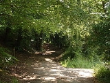
The Pilgrims' Way is the historic route supposed to have been taken by pilgrim
s from Winchester in Hampshire
, England
, to the shrine of Thomas Becket
at Canterbury
in Kent
. This name is somewhat misleading, as the route follows closely a pre-existing ancient trackway
dated by archaeological finds to 500–450 BC, but probably in existence since the stone age
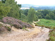
, following the "natural causeway" east to west on the southern slopes of the North Downs
.
The course was dictated by the natural geography: it took advantage of the contours, avoided the sticky clay of the land below but also the thinner, overlying "clay with flints" of the summits. In places a coexisting ridgeway
and terrace way can be identified, where the route followed would have varied with the season. The trackway ran the entire length of the North Downs, leading to and from Folkestone
: the pilgrims would have had to turn away from it, north along the valley of the Great Stour
near Chilham
, to reach Canterbury.
 The prehistoric trackway extended further than the present Way, providing a link from the narrowest part of the English Channel
to the important religious complexes of Avebury
and Stonehenge
, in Wiltshire, where it is known as the Harroway
. The route was still followed as an artery for through traffic in Roman times, a period of continuous use of more than 3000 years.
From Thomas Becket's canonization
in 1173 until the dissolution of the monasteries
in 1538 his shrine at Canterbury became the most important in the country, indeed "after Rome...the chief shrine in Christendom", and it drew pilgrims from far and wide. Winchester, apart from being an ecclesiastical centre in its own right (the shrine of St Swithin), was an important regional focus and an aggregation point for travellers arriving through the seaports on the south coast. Travellers from Winchester to Canterbury naturally used the ancient way, as it was the direct route, and research by local historians has provided much by way of detail—sometimes embellished—of the pilgrims' journeys. The numbers making their way to Canterbury by this route were not recorded, but the estimate by the Kentish historian William Coles Finch
that it carried more than 100,000 pilgrims a year is surely an exaggeration. A separate (and more reliably attested) route to Canterbury was by way of Watling Street
from London, as followed by the storytellers in The Canterbury Tales
by Geoffrey Chaucer
.
Indeed, the concept of a single route called the Pilgrims' Way seems to be no older than the Victorian Ordnance Survey
map of Surrey, whose surveyor, Edward Renouard James, published a pamphlet in 1871 entitled Notes on the Pilgrims' Way in West Surrey. Here he asserted that the route was "little studied" and that "very many persons in the neighbourhood" had not been aware of it. His insertion of the route name on the Ordnance map gave an official sanction to his conjecture; and writers such as Hilaire Belloc
were eager to follow it up. In fact, the route as shown on modern maps is not only unsuitable for the mass movement of travellers but has also left few traces of their activity. The official history of the Ordnance Survey acknowledges the "enduring archaeological blunder", blaming the enthusiasm for history of the then Director, General Sir Henry James
. Together, romantically inclined authors have succeeded in creating a "a fable of...modern origin" to explain the existence of the Way.
The Pilgrims' Way is at the centre of the Powell and Pressburger
film A Canterbury Tale
, with the camera panning along a map of the route at the start of the film.
 Anyone walking the 'Pilgrims Way' from Winchester
would have started along the Roman road
east following the route through New Alresford
, Alton
and Bentley
to Farnham. This roughly follows the modern A31
.
The ancient main streets of towns along the route from Farnham
(where the old trackway converges with the pilgrims' route) through Guildford
, Dorking
and Reigate
(where a pilgrims' chapel, dedicated to St Thomas, was established) — align west to east, strongly suggesting that this was the most important route that passed through them. On modern Ordnance Survey maps, part of the route is shown running east from Farnham
, passing to the south of Guildford
, north of the village of Gomshall, north of Dorking
, Reigate
, Merstham
, Chaldon
, Godstone
, Limpsfield
and Westerham
, through Otford
, Kemsing and Wrotham
, north of Trottiscliffe
, towards Cuxton
(where it crossed the River Medway
). Along some stretches the pilgrims' route left the ancient trackway to encompass religious sites, an example being at Pewley Down, near Guildford, where the later way passed St Martha's Hill
and The Chantries
, some 500 metres to the south. The thirteenth-century chapel of St Thomas at Reigate, although not on the route, was built for the pilgrims' use. South of Rochester, the Pilgrims' Way travels through the villages of Burham
, Boxley
, Detling
and continuing in a south-east direction to the north of the villages of Harrietsham
and Lenham
.
The route continues south-east along the top of the Downs past Charing
, to Wye
and then turns north to follow the valley of the Great Stour
through Chilham
and on to Canterbury
.
National Trail parallels the old Pilgrims' Way between Farnham and Canterbury. Much of the traditional route of the Pilgrims' Way is now part of the modern road network and the Ramblers' Association advises walkers wishing to follow it to use St. Swithuns Way
between Winchester and Farnham and the North Downs Way
between Farnham and Canterbury as an alternative.
The route also links with the South Downs Way
at Winchester.
Pilgrim
A pilgrim is a traveler who is on a journey to a holy place. Typically, this is a physical journeying to some place of special significance to the adherent of a particular religious belief system...
s from Winchester in Hampshire
Hampshire
Hampshire is a county on the southern coast of England in the United Kingdom. The county town of Hampshire is Winchester, a historic cathedral city that was once the capital of England. Hampshire is notable for housing the original birthplaces of the Royal Navy, British Army, and Royal Air Force...
, England
England
England is a country that is part of the United Kingdom. It shares land borders with Scotland to the north and Wales to the west; the Irish Sea is to the north west, the Celtic Sea to the south west, with the North Sea to the east and the English Channel to the south separating it from continental...
, to the shrine of Thomas Becket
Thomas Becket
Thomas Becket was Archbishop of Canterbury from 1162 until his murder in 1170. He is venerated as a saint and martyr by both the Roman Catholic Church and the Anglican Communion...
at Canterbury
Canterbury
Canterbury is a historic English cathedral city, which lies at the heart of the City of Canterbury, a district of Kent in South East England. It lies on the River Stour....
in Kent
Kent
Kent is a county in southeast England, and is one of the home counties. It borders East Sussex, Surrey and Greater London and has a defined boundary with Essex in the middle of the Thames Estuary. The ceremonial county boundaries of Kent include the shire county of Kent and the unitary borough of...
. This name is somewhat misleading, as the route follows closely a pre-existing ancient trackway
Ancient trackway
Ancient trackway can refer to any track or trail whose origin is lost in antiquity. Such paths existed from the earliest prehistoric times and in every inhabited part of the globe...
dated by archaeological finds to 500–450 BC, but probably in existence since the stone age
Stone Age
The Stone Age is a broad prehistoric period, lasting about 2.5 million years , during which humans and their predecessor species in the genus Homo, as well as the earlier partly contemporary genera Australopithecus and Paranthropus, widely used exclusively stone as their hard material in the...
, following the "natural causeway" east to west on the southern slopes of the North Downs
North Downs
The North Downs are a ridge of chalk hills in south east England that stretch from Farnham in Surrey to the White Cliffs of Dover in Kent. The North Downs lie within two Areas of Outstanding Natural Beauty , the Surrey Hills and the Kent Downs...
.
The course was dictated by the natural geography: it took advantage of the contours, avoided the sticky clay of the land below but also the thinner, overlying "clay with flints" of the summits. In places a coexisting ridgeway
Ridgeway
A ridgeway is a road or path that follows a ridge, or the highest part of the landscape.-Roads and pathways:*The Ridgeway, an ancient track in southern England, which now forms part of the Ridgeway Path or National Trail...
and terrace way can be identified, where the route followed would have varied with the season. The trackway ran the entire length of the North Downs, leading to and from Folkestone
Folkestone
Folkestone is the principal town in the Shepway District of Kent, England. Its original site was in a valley in the sea cliffs and it developed through fishing and its closeness to the Continent as a landing place and trading port. The coming of the railways, the building of a ferry port, and its...
: the pilgrims would have had to turn away from it, north along the valley of the Great Stour
River Stour, Kent
The River Stour is the river in Kent, England that flows into the English Channel at Pegwell Bay. Above Plucks Gutter, where the Little Stour joins it, the river is normally known as the Great Stour. The upper section of the river, above its confluence with the East Stour at Ashford is sometimes...
near Chilham
Chilham
Chilham is a parish in the English county of Kent. Visited by tourists worldwide, it is known for its beauty. Chilham has been a location for a number of films and television dramas...
, to reach Canterbury.
History
English Channel
The English Channel , often referred to simply as the Channel, is an arm of the Atlantic Ocean that separates southern England from northern France, and joins the North Sea to the Atlantic. It is about long and varies in width from at its widest to in the Strait of Dover...
to the important religious complexes of Avebury
Avebury
Avebury is a Neolithic henge monument containing three stone circles which is located around the village of Avebury in Wiltshire, south west England. Unique amongst megalithic monuments, Avebury contains the largest stone circle in Europe, and is one of the best known prehistoric sites in Britain...
and Stonehenge
Stonehenge
Stonehenge is a prehistoric monument located in the English county of Wiltshire, about west of Amesbury and north of Salisbury. One of the most famous sites in the world, Stonehenge is composed of a circular setting of large standing stones set within earthworks...
, in Wiltshire, where it is known as the Harroway
Harrow Way
The Harrow Way forms the western part of the Old Way, an ancient trackway in the south of England, dating from the Neolithic period, which can be traced from Rochester and the Channel ports in the Straits of Dover along the North Downs and through Guildford, Farnham, Andover and Basingstoke to...
. The route was still followed as an artery for through traffic in Roman times, a period of continuous use of more than 3000 years.
From Thomas Becket's canonization
Canonization
Canonization is the act by which a Christian church declares a deceased person to be a saint, upon which declaration the person is included in the canon, or list, of recognized saints. Originally, individuals were recognized as saints without any formal process...
in 1173 until the dissolution of the monasteries
Dissolution of the Monasteries
The Dissolution of the Monasteries, sometimes referred to as the Suppression of the Monasteries, was the set of administrative and legal processes between 1536 and 1541 by which Henry VIII disbanded monasteries, priories, convents and friaries in England, Wales and Ireland; appropriated their...
in 1538 his shrine at Canterbury became the most important in the country, indeed "after Rome...the chief shrine in Christendom", and it drew pilgrims from far and wide. Winchester, apart from being an ecclesiastical centre in its own right (the shrine of St Swithin), was an important regional focus and an aggregation point for travellers arriving through the seaports on the south coast. Travellers from Winchester to Canterbury naturally used the ancient way, as it was the direct route, and research by local historians has provided much by way of detail—sometimes embellished—of the pilgrims' journeys. The numbers making their way to Canterbury by this route were not recorded, but the estimate by the Kentish historian William Coles Finch
William Coles Finch
William Coles Finch M. Inst. C. E. was a British historian and author of a number of books on Kent-related topics. He is best known for writing Watermills and Windmills, published in 1933 and reprinted in 1976, which is considered a standard work on the topic of Kent windmills.-Personal:William...
that it carried more than 100,000 pilgrims a year is surely an exaggeration. A separate (and more reliably attested) route to Canterbury was by way of Watling Street
Watling Street
Watling Street is the name given to an ancient trackway in England and Wales that was first used by the Britons mainly between the modern cities of Canterbury and St Albans. The Romans later paved the route, part of which is identified on the Antonine Itinerary as Iter III: "Item a Londinio ad...
from London, as followed by the storytellers in The Canterbury Tales
The Canterbury Tales
The Canterbury Tales is a collection of stories written in Middle English by Geoffrey Chaucer at the end of the 14th century. The tales are told as part of a story-telling contest by a group of pilgrims as they travel together on a journey from Southwark to the shrine of Saint Thomas Becket at...
by Geoffrey Chaucer
Geoffrey Chaucer
Geoffrey Chaucer , known as the Father of English literature, is widely considered the greatest English poet of the Middle Ages and was the first poet to have been buried in Poet's Corner of Westminster Abbey...
.
Indeed, the concept of a single route called the Pilgrims' Way seems to be no older than the Victorian Ordnance Survey
Ordnance Survey
Ordnance Survey , an executive agency and non-ministerial government department of the Government of the United Kingdom, is the national mapping agency for Great Britain, producing maps of Great Britain , and one of the world's largest producers of maps.The name reflects its creation together with...
map of Surrey, whose surveyor, Edward Renouard James, published a pamphlet in 1871 entitled Notes on the Pilgrims' Way in West Surrey. Here he asserted that the route was "little studied" and that "very many persons in the neighbourhood" had not been aware of it. His insertion of the route name on the Ordnance map gave an official sanction to his conjecture; and writers such as Hilaire Belloc
Hilaire Belloc
Joseph Hilaire Pierre René Belloc was an Anglo-French writer and historian who became a naturalised British subject in 1902. He was one of the most prolific writers in England during the early twentieth century. He was known as a writer, orator, poet, satirist, man of letters and political activist...
were eager to follow it up. In fact, the route as shown on modern maps is not only unsuitable for the mass movement of travellers but has also left few traces of their activity. The official history of the Ordnance Survey acknowledges the "enduring archaeological blunder", blaming the enthusiasm for history of the then Director, General Sir Henry James
Henry James (Ordnance Survey)
Major General Sir Henry James FRS MRIA RE was the director-general of the Ordnance Survey, the British Government mapping agency, from 1854 to 1875. Sir Henry was described by the agency itself as "perhaps Ordnance Survey's most eccentric and egotistical Director General"...
. Together, romantically inclined authors have succeeded in creating a "a fable of...modern origin" to explain the existence of the Way.
The Pilgrims' Way is at the centre of the Powell and Pressburger
Powell and Pressburger
The British film-making partnership of Michael Powell and Emeric Pressburger, also known as The Archers, made a series of influential films in the 1940s and 1950s. In 1981 they were recognized for their contributions to British cinema with the BAFTA Academy Fellowship Award, the most prestigious...
film A Canterbury Tale
A Canterbury Tale
A Canterbury Tale is a 1944 British film by the film-making team of Michael Powell and Emeric Pressburger. It stars Eric Portman, Sheila Sim, Dennis Price and Sgt. John Sweet; Esmond Knight provided narration and played several small roles. For the postwar American release, Raymond Massey narrated...
, with the camera panning along a map of the route at the start of the film.
Route
Winchester
Winchester is a historic cathedral city and former capital city of England. It is the county town of Hampshire, in South East England. The city lies at the heart of the wider City of Winchester, a local government district, and is located at the western end of the South Downs, along the course of...
would have started along the Roman road
Roman road
The Roman roads were a vital part of the development of the Roman state, from about 500 BC through the expansion during the Roman Republic and the Roman Empire. Roman roads enabled the Romans to move armies and trade goods and to communicate. The Roman road system spanned more than 400,000 km...
east following the route through New Alresford
New Alresford
New Alresford or simply Alresford is a small town and civil parish in the City of Winchester district of Hampshire, England. It is situated some 12 km north-east of the city of Winchester and 20 km south-west of the town of Alton...
, Alton
Alton, Hampshire
Alton is a historic market town and civil parish in the East Hampshire district of the English county of Hampshire. It had a population of 16,584 at the 1991 census and is administered by East Hampshire district council. It is located on the source of the River Wey and is the highest town in...
and Bentley
Bentley, Hampshire
Bentley is a village and civil parish in the East Hampshire district of Hampshire, England. The parish has an acreage of . The village is located just off the A31 road between Farnham in Surrey and Alton, being about five miles west of Farnham and six miles east of Alton...
to Farnham. This roughly follows the modern A31
A31 road
The A31 is a major trunk road in southern England that runs from Guildford in Surrey to Bere Regis in Dorset.-Route of road:The road begins in the centre of Guildford, meeting the A3 road before running south west along the Hog's Back. It continues past Farnham, Alton and New Alresford before...
.
The ancient main streets of towns along the route from Farnham
Farnham
Farnham is a town in Surrey, England, within the Borough of Waverley. The town is situated some 42 miles southwest of London in the extreme west of Surrey, adjacent to the border with Hampshire...
(where the old trackway converges with the pilgrims' route) through Guildford
Guildford
Guildford is the county town of Surrey. England, as well as the seat for the borough of Guildford and the administrative headquarters of the South East England region...
, Dorking
Dorking
Dorking is a historic market town at the foot of the North Downs approximately south of London, in Surrey, England.- History and development :...
and Reigate
Reigate
Reigate is a historic market town in Surrey, England, at the foot of the North Downs, and in the London commuter belt. It is one of the main constituents of the Borough of Reigate and Banstead...
(where a pilgrims' chapel, dedicated to St Thomas, was established) — align west to east, strongly suggesting that this was the most important route that passed through them. On modern Ordnance Survey maps, part of the route is shown running east from Farnham
Farnham
Farnham is a town in Surrey, England, within the Borough of Waverley. The town is situated some 42 miles southwest of London in the extreme west of Surrey, adjacent to the border with Hampshire...
, passing to the south of Guildford
Guildford
Guildford is the county town of Surrey. England, as well as the seat for the borough of Guildford and the administrative headquarters of the South East England region...
, north of the village of Gomshall, north of Dorking
Dorking
Dorking is a historic market town at the foot of the North Downs approximately south of London, in Surrey, England.- History and development :...
, Reigate
Reigate
Reigate is a historic market town in Surrey, England, at the foot of the North Downs, and in the London commuter belt. It is one of the main constituents of the Borough of Reigate and Banstead...
, Merstham
Merstham
Merstham is a village in the Reigate and Banstead borough of Surrey, England, in the London commuter belt. It is just north of Redhill, near the intersection of the M25 and M23 motorways, on the edge of the North Downs and on the North Downs Way.-History:...
, Chaldon
Chaldon
Chaldon is a village in Surrey, England on the North Downs to the west of Caterham. It falls within the boundaries of Tandridge district.The village lay within the Anglo-Saxon administrative division of Wallington hundred....
, Godstone
Godstone railway station
Godstone railway station is on the Redhill to Tonbridge Line and serves Godstone in Surrey, England. It is located approximately two miles south of the village centre, at South Godstone, a settlement which was non-existent until the coming of the railway....
, Limpsfield
Limpsfield
Limpsfield is a village and parish in the east of the county of Surrey, England near Oxted at the foot of the North Downs. It lies between the A25 to the south and the M25 motorway to the north, near the Clackett Lane service station...
and Westerham
Westerham
Westerham is a town and civil parish in the Sevenoaks District of Kent, in South East England with 5,000 people. The parish is south of the North Downs, ten miles west of Sevenoaks. It covers 5800 acres . It is recorded as early as the 9th century, and was mentioned in the Domesday Book in a...
, through Otford
Otford
Otford is a village and civil parish in the Sevenoaks District of Kent known for its classically British countryside. The village is located on the River Darent, flowing north down its valley from its source on the North Downs...
, Kemsing and Wrotham
Wrotham
Wrotham is a village situated on the Pilgrims' Way in Kent, at the foot of the North Downs. It is located one mile north of Borough Green and approximately five miles east of Sevenoaks. It is within the junction of the M20 and M26 motorways....
, north of Trottiscliffe
Trottiscliffe
Trottiscliffe , is a village in Kent, England about north west of West Malling.Its most notable feature is the neolithic long barrow known as the Coldrum Stones and its medieval church. It is often incorrectly spelled Trosley after Trosley Country Park at the top of The North Downs, which was once...
, towards Cuxton
Cuxton
Cuxton is a village in the unitary authority of Medway. It lies on left bank of the River Medway in the North Downs. It is served by the A228, and Cuxton railway station on the Medway Valley Line between Strood and Maidstone...
(where it crossed the River Medway
River Medway
The River Medway, which is almost entirely in Kent, England, flows for from just inside the West Sussex border to the point where it enters the Thames Estuary....
). Along some stretches the pilgrims' route left the ancient trackway to encompass religious sites, an example being at Pewley Down, near Guildford, where the later way passed St Martha's Hill
St. Martha's Hill
St Martha's Hill is a landmark of the parish of St Martha's in Surrey, England, situated between Guildford and Chilworth, Surrey. It is a prominent hill on the Greensand Ridge just to the south of the North Downs in southeast England. The top of the hill provides good views of Newland's Corner and...
and The Chantries
Chantry
Chantry is the English term for a fund established to pay for a priest to celebrate sung Masses for a specified purpose, generally for the soul of the deceased donor. Chantries were endowed with lands given by donors, the income from which maintained the chantry priest...
, some 500 metres to the south. The thirteenth-century chapel of St Thomas at Reigate, although not on the route, was built for the pilgrims' use. South of Rochester, the Pilgrims' Way travels through the villages of Burham
Burham
Burham is a village and civil parish in the Tonbridge and Malling district ofKent, England. According to the 2001 census it had a population of 1,251. The village is near the Medway towns.The history of Burham can be traced to Roman times...
, Boxley
Boxley
The large village and civil parish of Boxley in the Maidstone District of Kent, England lies below the slope of the North Downs, four miles NE of Maidstone town...
, Detling
Detling
Detling is a village and civil parish in the Borough of Maidstone in Kent, England. The parish is located on the slope of the North Downs, north east of Maidstone, and on the Pilgrims' Way....
and continuing in a south-east direction to the north of the villages of Harrietsham
Harrietsham
Harrietsham is a rural village and civil parish in the Maidstone District of Kent, England. According to the United Kingdom Census 2001, it has a population of around 1,504. The parish is located on the slope of the North Downs, east of Maidstone...
and Lenham
Lenham
Lenham is a market village in Kent situated on the southern edge of the North Downs, halfway between Maidstone and Ashford. The picturesque square in the village has two public houses , a couple of restaurants, and a tea-room....
.
The route continues south-east along the top of the Downs past Charing
Charing
Charing is a small village and civil parish in the Ashford District of Kent, in south-east England. The parish population is 2,750 ; it includes the settlement of Charing Heath.It is situated at the foot of the North Downs...
, to Wye
Wye
Wye is a historic village in Kent, England, located some from Canterbury, and is also the main village in the civil parish of Wye with Hinxhill...
and then turns north to follow the valley of the Great Stour
River Stour, Kent
The River Stour is the river in Kent, England that flows into the English Channel at Pegwell Bay. Above Plucks Gutter, where the Little Stour joins it, the river is normally known as the Great Stour. The upper section of the river, above its confluence with the East Stour at Ashford is sometimes...
through Chilham
Chilham
Chilham is a parish in the English county of Kent. Visited by tourists worldwide, it is known for its beauty. Chilham has been a location for a number of films and television dramas...
and on to Canterbury
Canterbury
Canterbury is a historic English cathedral city, which lies at the heart of the City of Canterbury, a district of Kent in South East England. It lies on the River Stour....
.
Walk
The North Downs WayNorth Downs Way
The North Downs Way is a long-distance path in southern England, opened in 1978. It runs from Farnham to Dover, past Godalming, Guildford, Dorking, Merstham, Otford and Rochester, along the Surrey Hills Area of Outstanding Natural Beauty and Kent Downs AONB.East of Boughton Lees, the path splits...
National Trail parallels the old Pilgrims' Way between Farnham and Canterbury. Much of the traditional route of the Pilgrims' Way is now part of the modern road network and the Ramblers' Association advises walkers wishing to follow it to use St. Swithuns Way
St. Swithuns Way
St. Swithuns Way is a long-distance footpath in England from Winchester Cathedral, Hampshire to Farnham, Surrey.The route is partially waymarked by circular discs attached to wooden posts and street furniture....
between Winchester and Farnham and the North Downs Way
North Downs Way
The North Downs Way is a long-distance path in southern England, opened in 1978. It runs from Farnham to Dover, past Godalming, Guildford, Dorking, Merstham, Otford and Rochester, along the Surrey Hills Area of Outstanding Natural Beauty and Kent Downs AONB.East of Boughton Lees, the path splits...
between Farnham and Canterbury as an alternative.
The route also links with the South Downs Way
South Downs Way
The South Downs Way is a long distance footpath and bridleway running along the South Downs in southern England, and is one of 15 National Trails in England and Wales...
at Winchester.
External links
- A short history of the Pilgrims' Way, Countryside AgencyCountryside AgencyThe Countryside Agency in England was a statutory body set up in 1999 with the task of improving the quality of the rural environment and the lives of those living in it. The Agency was formed by merging the Countryside Commission and the Rural Development Commission...
- Pilgrims' Way Net - History and resource site for the Pilgrims' Way