
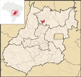
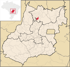
Nova Iguaçu de Goiás
Encyclopedia
| Nova Iguaçu de Goiás | |
|---|---|
| State | Goiás Goiás Goiás is a state of Brazil, located in the central part of the country. The name Goiás comes from the name of an indigenous community... |
| Area: | 628 km² |
| Population: | 2,622 (IBGE 2007) |
| Elevation: | 409 m above sea level |
| Postcode (CEP): | 76495-000 |
| Became a city: | 1993 |
| Distance to Goiânia Goiânia -Climate:The city has a tropical wet and dry climate with an average temperature of . There's a wet season, from October to April, and a dry one, from May to September. Annual rainfall is around 1,520 mm.... : |
338 km. |
| IBGE statistical microregion: | Porangatu Microregion Porangatu Microregion The Porangatu Microregion is a statistical region created by IBGE in north-central Goiás state, Brazil. The most important city is Porangatu... |
| Website: | none |
Town
A town is a human settlement larger than a village but smaller than a city. The size a settlement must be in order to be called a "town" varies considerably in different parts of the world, so that, for example, many American "small towns" seem to British people to be no more than villages, while...
and municipality
Municipality
A municipality is essentially an urban administrative division having corporate status and usually powers of self-government. It can also be used to mean the governing body of a municipality. A municipality is a general-purpose administrative subdivision, as opposed to a special-purpose district...
in north Goiás
Goiás
Goiás is a state of Brazil, located in the central part of the country. The name Goiás comes from the name of an indigenous community...
state, Brazil
Brazil
Brazil , officially the Federative Republic of Brazil , is the largest country in South America. It is the world's fifth largest country, both by geographical area and by population with over 192 million people...
.
Location
Nova Iguaçu de Goiás is located in the extreme north of the state and is 136 km from the regional center of PorangatuPorangatu
Parangatu is a town in Goiás state, Brazil-Geography:Parangatu is in its own microregion, Porangatu Microregion, of 226,766 inhabitants in an area of 35.287 km²; 426 km from the state capital, Goiânia. This microregion serves as a nucleus for eighteen municipalities in the north of Goiás state...
. Other towns nearby are Campinorte
Campinorte
Campinorte is a small city and municipality in north-central Goiás state, Brazil. The population was 9,697 in a total area of 1,068 km².-Location:...
, 28 km. to the east; Alto Horizonte
Alto Horizonte
Alto Horizonte is a small town and municipality in north Goiás state, Brazil. The population was 3,136 in 2007 and the area of the municipality was 503.7 km².-Location:...
, 12 km. to the north; and Santa Terezinha de Goiás
Santa Terezinha de Goiás
Santa Terezinha de Goiás is a small city and municipality in north Goiás state, Brazil. Santa Terezinha is sometimes written as ""Santa Teresinha".-Location:...
, 38 km. to the southwest.
Nova Iguaçu de Goiás is surrounded by the following municipalities:
- north: Alto HorizonteAlto HorizonteAlto Horizonte is a small town and municipality in north Goiás state, Brazil. The population was 3,136 in 2007 and the area of the municipality was 503.7 km².-Location:...
and Mara RosaMara RosaMara Rosa is a small town and municipality in north-central Goiás state, Brazil.-Location:Mara Rosa is located 356 kilometers north of Goiânia in the Porangatu Microregion. It is 11 kilometers east of the Belém-Brasília highway, between the basins of the Araguaia River and the Tocantins River... - south: UruaçuUruaçuUruaçu is a small city and municipality in north Goiás state, Brazil.-Geography:Uruaçu is located north of Anápolis and Goiânia on the important interstate highway BR-153, which links Brasília to Belém. It is 269 km. from Goiânia and 244 km. from Brasília...
- east: CampinorteCampinorteCampinorte is a small city and municipality in north-central Goiás state, Brazil. The population was 9,697 in a total area of 1,068 km².-Location:...
- west: Campos Verdes de Goiás
The distance to Goiânia
Goiânia
-Climate:The city has a tropical wet and dry climate with an average temperature of . There's a wet season, from October to April, and a dry one, from May to September. Annual rainfall is around 1,520 mm....
is 338 km. Highway connections are made by GO-080 / Nerópolis
Nerópolis
Nerópolis is a small city and municipality in central Goiás state, Brazil.-Location:The municipality is part of the metropolitan region of Goiânia, which is 42 kilometers to the west. It is nationally known as the city of garlic and sweets...
/ São Francisco de Goiás
São Francisco de Goiás
São Francisco de Goiás is a small town and municipality in central Goiás state, Brazil.Municipal boundaries:*North: Jaraguá*South: Petrolina de Goiás*East: Pirenópolis*West: Jesúpolis and Jaraguá...
/ BR-153 / Jaraguá / GO-080 / Goianésia
Goianésia
Goianésia is a municipality in the state of Goiás, Brazil. It is a large producer of sugarcane for production of alcohol used as a source of fuel.-Location:...
/ Barro Alto
Barro Alto
Barro Alto is a small town and municipality in northern Goiás state, Brazil, famous for its nickel mine and production of rubber. The population was 6,446 in 2007 and the total area of the municipality was 1,231.8 km².-Location:...
/ GO-342 / BR-080 / BR-153 / Uruaçu
Uruaçu
Uruaçu is a small city and municipality in north Goiás state, Brazil.-Geography:Uruaçu is located north of Anápolis and Goiânia on the important interstate highway BR-153, which links Brasília to Belém. It is 269 km. from Goiânia and 244 km. from Brasília...
/ Campinorte
Campinorte
Campinorte is a small city and municipality in north-central Goiás state, Brazil. The population was 9,697 in a total area of 1,068 km².-Location:...
/ GO-428.
Political and Demographic Information
In January 2005 the mayor was Adelino Serra Alves. There were 9 city-council members and the number of eligible voters was 2,240 (2007). In 2007 the population density was 4.17 inhab/km². There were 1,763 urban inhabitants and 859 rural inhabitants. The population has been in decline since the first census in 1996, losing almost 500 residents. Population growth rate: -0,71% 1996/2007Economic Information
The economy is based on modest transformation industries, services, public employment, cattle raising, and agriculture. In 2007 there were 4 industrial and 17 retail units. In 2007 there were 109 automobiles in the town.Agricultural Census (2006)
- Farms: 237
- Planted area: 1,135 hectares
- Natural Pasture: 53,300 hectares
- Woodland and Forest: 28,824 hectares
- Persons occupied related to the farm owner: 596
- Persons occupied not related to the farm owner: 50
- Cattle: 39,000 head
- rice: 280 hectares
- corn: 400 hectares (IBGE 2006)
Health and education
In 2007 there were no hospitals and only one walk-in health clinic. The infant mortality rate was 27.56, below the national average of 33.0. In 2006 the school system had 5 schools and 788 students. There was one middle school with 170 students. In 2000 the adult literacy rate was 84.3%, below the national average of 86.4%.Ranking on Development Indexes
Municipal Human Development IndexHuman Development Index
The Human Development Index is a composite statistic used to rank countries by level of "human development" and separate "very high human development", "high human development", "medium human development", and "low human development" countries...
- Nova Iguaçu de Goiás is ranked 166 out of 242 municipalities on the MHDI-M.
- MHDI: 0.723
- State ranking: 166 (out of 246 municipalities)
- National ranking: 2,571 (out of 5,505 municipalities)
Index of Economic Development (Seplan 2001)
- 229/246 municipalities. See Seplan
Index of Social Development (Seplan 2000)
- 240/246 municipalities. See Seplan