

Pictorial maps
Encyclopedia

MAPS
Maps is the plural of map, a visual representation of an area.As an acronym, MAPS may refer to:* Mail Abuse Prevention System, an organisation that provides anti-spam support...
that are also loosely called illustrated maps, panoramic maps, perspective maps, bird’s-eye view maps and Geopictorial maps amongst others. In contrast to the regular road map, Atlas or topographic cartography
Cartography
Cartography is the study and practice of making maps. Combining science, aesthetics, and technique, cartography builds on the premise that reality can be modeled in ways that communicate spatial information effectively.The fundamental problems of traditional cartography are to:*Set the map's...
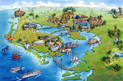
, pictorial maps depict a given territory with a more artistic rather than technical style. The cartography can be a sophisticated 3-D perspective landscape or a simple map graphic enlivened with illustrations of buildings, people and animals. They can feature all sorts of varied topics like historical events, legendary figures or local agricultural products and cover anything from an entire continent to a college campus. Drawn by specialized artists and illustrators, pictorial maps are a rich, centuries-old tradition and a diverse art form that ranges from cartoon maps on restaurant placemats to treasured art prints in museums.
Pictorial maps usually show an area as if viewed from above at an oblique angle. They are not generally drawn to scale in order to show street patterns, individual buildings, and major landscape features in perspective. While regular maps focus on the accurate rendition of distances, pictorial maps enhance landmarks and often incorporate a complex interplay of different scales into one image in order to give the viewer a more familiar sense of recognition. With an emphasis on objects and style, these maps cover an artistic spectrum from childlike caricature to spectacular landscape graphic with the better ones being attractive, informative and highly accurate. Some require thousands of hours to produce.
The history and tradition of pictorial maps
Will DurantWill Durant
William James Durant was a prolific American writer, historian, and philosopher. He is best known for The Story of Civilization, 11 volumes written in collaboration with his wife Ariel Durant and published between 1935 and 1975...
said that maps show us the face of History. This is especially true of pictorial maps because their vocation has always been to present a visual message. Throughout the ages, pictorial maps have been used to show the cuisine of a country, the industries of a city, the attractions of a tourist town, the history of a region or its holy shrines.
History of cartography
Cartography , or mapmaking, has been an integral part of the human story for a long time, possibly up to 8,000 years...
in general and ancient artifacts suggest that pictorial mapping has been around since recorded history began.
In Medieval cartography, pictorial icons as well as religious and historical ideas usually overshadowed accurate geographic proportions. A classic example of this is the T and O map
T and O map
A T and O map or O-T or T-O map , is a type of medieval world map, sometimes also called a Beatine map or a Beatus map because one of the earliest known representations of this sort is attributed to Beatus of Liébana, an 8th-century Spanish monk...
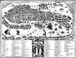
which represented the three known continents in the form of a cross with Jerusalem at its center. The more precise art of illustrating detailed bird’s-eye-view urban landscapes flourished during the European Renaissance. As emerging trade centers such as Venice began to prosper, local rulers commissioned artists to develop pictorial overviews of their towns to help them organize trade fairs and direct the increasing flow of visiting merchants. When printing came around, pictorial maps evolved into some of the earliest forms of advertising as cities competed amongst themselves to attract larger shares of the known world’s commerce.
The 19th Century

Library of Congress
The Library of Congress is the research library of the United States Congress, de facto national library of the United States, and the oldest federal cultural institution in the United States. Located in three buildings in Washington, D.C., it is the largest library in the world by shelf space and...
and many of the more beautiful ones continue to be reprinted and sold to this day .
The 20th Century
With the growth of tourism, pictorial mapmaking reappeared as a popular culture art form in the 1920s through the 1950s, often with a whimsical Art DecoArt Deco
Art deco , or deco, is an eclectic artistic and design style that began in Paris in the 1920s and flourished internationally throughout the 1930s, into the World War II era. The style influenced all areas of design, including architecture and interior design, industrial design, fashion and...
style that reflects the period.
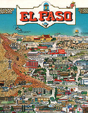
Another resurgence occurred in the 1970s and 80s. This was the heyday of companies like Archar and Descartes who produced hundreds of colorful promotional maps of mainly American and Canadian cities. Local businesses were flatteringly drawn on these 'Character maps' with their logos proudly embedded on their buildings. Looking at these maps and who sponsored them over the years, one can clearly see the changing face of industry as the dominant illustrations of manufacturing plants gave way to those of business parks and logos of the service and high tech economy.
Whether drawn with quill, pen or pixels, pictorial maps are always scaled in the perspective of the imagination.
Pictorial Map-makers up to modern times

Edwin Whitefield
Edwin Whitefield was a landscape artist who is best known for his lithographed views of North American cities and for a number of illustrated books on colonial homes in New England. See: pictorial maps...
for instance, one of the more prolific 19th century American pictorial map artists, would require about 200 subscribers before he put pen to paper. Once he secured the profitability of the venture, Whitefield would be seen all over town furiously sketching every building. Then, choosing an imaginary aerial vantage point, he would integrate all his sketches into a complete and detailed drawing of the city. Then after that, say the chroniclers of the time, Whitefield would once again be seen furiously darting all over town to collect from all his sponsors.
Says Jean-Louis Rheault, a contemporary pictorial map illustrator: 'Pictorial maps - with their emphasis on what's important and eye-catching - make it easier to figure out what's where.'.
See also
- Aerial photographyAerial photographyAerial photography is the taking of photographs of the ground from an elevated position. The term usually refers to images in which the camera is not supported by a ground-based structure. Cameras may be hand held or mounted, and photographs may be taken by a photographer, triggered remotely or...
- Animated mappingAnimated mappingAnimated mapping is the application of animation, either computer or video, to add a temporal component to a map displaying change in some dimension. Most commonly the change is shown over time, generally at a greatly changed scale...
- British Cartographic SocietyBritish Cartographic SocietyThe British Cartographic Society is an association of individuals and organisations dedicated to exploring and developing the world of maps. It is a registered charity...
- CartogramCartogramA cartogram is a map in which some thematic mapping variable – such as travel time or Gross National Product – is substituted for land area or distance. The geometry or space of the map is distorted in order to convey the information of this alternate variable...
- Cartographic relief depictionCartographic relief depictionTerrain or relief is an essential aspect of physical geography, and as such its portrayal presents a central problem in cartography, and more recently GIS and 3D Visualization....
- Cartographic generalizationCartographic generalizationCartographic generalization is the method whereby information is selected and represented on a map in a way that adapts to the scale of the display medium of the map, not necessarily preserving all intricate geographical or other cartographic details...
- Contour lineContour lineA contour line of a function of two variables is a curve along which the function has a constant value. In cartography, a contour line joins points of equal elevation above a given level, such as mean sea level...
- Critical cartographyCritical cartographyCritical Cartography is a set of new mapping practices and theoretical critique grounded in critical theory. It differs from academic cartography in that it links geographic knowledge with power, and thus is political...
- Digital Cadastral DataBaseDigital Cadastral DataBaseDigital Cadastral DataBase is a computerised map or 'spatial' location showing property boundaries normally in relation to adjoining and other close properties or parcels of land. Commonly used as a basic layer of data used in map based computer programs that gives an outline of the legal...
- Fantasy mapFantasy mapA fantasy map is type of map design that is a visual representation of an imaginary or fictional geography. While some fantasy maps accompany works of fiction and are considered fictional maps, fantasy maps are created to show imaginary places and are not necessarily included in works of literary...
- Figure-ground in map designFigure-ground in map designAn effectively designed map is one in which the intended message is clearly communicated to the map user. By employing the concept of figure-ground, a viewer can easily distinguish between the main figure on a map and the background information...
- Four color theoremFour color theoremIn mathematics, the four color theorem, or the four color map theorem states that, given any separation of a plane into contiguous regions, producing a figure called a map, no more than four colors are required to color the regions of the map so that no two adjacent regions have the same color...
- GazetteerGazetteerA gazetteer is a geographical dictionary or directory, an important reference for information about places and place names , used in conjunction with a map or a full atlas. It typically contains information concerning the geographical makeup of a country, region, or continent as well as the social...
- GeocodeGeocodeGEOCODE is a standardized all-natural number representation format specification for geospatial coordinate measurements that provide details of the exact location of geospatial point at, below, or above the surface of the earth at a specified moment of time.Geocode is patented under US Patents...
- Geographic Information SystemGeographic Information SystemA geographic information system, geographical information science, or geospatial information studies is a system designed to capture, store, manipulate, analyze, manage, and present all types of geographically referenced data...
(GIS) - GeovisualizationGeovisualizationGeovisualization, short for Geographic Visualization, refers to a set of tools and techniques supporting geospatial data analysis through the use of interactive visualization....
- Here be dragonsHere be dragons"Here be dragons" is a phrase used to denote dangerous or unexplored territories, in imitation of the medieval practice of putting sea serpents and other mythological creatures in uncharted areas of maps.-History:...
- IsostasyIsostasyIsostasy is a term used in geology to refer to the state of gravitational equilibrium between the earth's lithosphere and asthenosphere such that the tectonic plates "float" at an elevation which depends on their thickness and density. This concept is invoked to explain how different topographic...
- Japanese map symbolsJapanese map symbolsThis is a list of symbols appearing on Japanese maps. These symbols are called in the Japanese language.symbolmeaningillustrationsymbolmeaningillustrationMunicipal building Municipal building...
- List of cartographers
- Locator mapLocator mapA locator map, sometimes referred to simply as a locator, is typically a simple map used in cartography to show the location of a particular geographic area within its larger and presumably more familiar context...
- Map projectionMap projectionA map projection is any method of representing the surface of a sphere or other three-dimensional body on a plane. Map projections are necessary for creating maps. All map projections distort the surface in some fashion...
- National Geospatial-Intelligence AgencyNational Geospatial-Intelligence AgencyThe National Geospatial-Intelligence Agency is an agency of the federal government of the United States with the primary mission of collecting, analyzing and distributing geospatial intelligence in support of national security. NGA was formerly known as the National Imagery and Mapping Agency ...
- OpenStreetMapOpenStreetMapOpenStreetMap is a collaborative project to create a free editable map of the world. Two major driving forces behind the establishment and growth of OSM have been restrictions on use or availability of map information across much of the world and the advent of inexpensive portable GPS devices.The...
, a free project mapping the world's roads using GPSGlobal Positioning SystemThe Global Positioning System is a space-based global navigation satellite system that provides location and time information in all weather, anywhere on or near the Earth, where there is an unobstructed line of sight to four or more GPS satellites... - OrthophotoOrthophotoAn orthophoto, orthophotograph or orthoimage is an aerial photograph geometrically corrected such that the scale is uniform: the photo has the same lack of distortion as a map...
- Pictorial maps
- Planetary cartographyPlanetary cartographyPlanetary Cartography includes all cartographic materials produced for objects with solid surfaces external to the Earth. This can include any spatially mapped characteristic for extraterrestrial surfaces. Also can be referred to as the Cartography of Extraterrestrial Objects...
- Point of BeginningPoint of BeginningThe point of beginning is a surveyor's mark at the beginning location for the wide-scale surveying of land.An example is the Beginning Point of the U.S. Public Land Survey that led to the opening of the Northwest Territory, and is the starting point of the surveys of almost all other lands to the...
- Sea levelSea levelMean sea level is a measure of the average height of the ocean's surface ; used as a standard in reckoning land elevation...
- Terra incognitaTerra incognitaTerra incognita or terra ignota is a term used in cartography for regions that have not been mapped or documented. The expression is believed to be first seen in Ptolemy’s Geography circa 150 CE...