
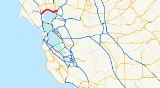
California State Route 37
Encyclopedia
State Route 37 is a state highway
in the northern
part of the U.S. state
of California
that runs 21 miles (34 km) along the northern shore of San Pablo Bay
. It is built from U.S. Route 101 in Novato
and runs through the southern tips of Sonoma
and Napa
Counties to Interstate 80 in Vallejo
. It serves as a vital connection between the four counties of the North Bay Area
, north of San Francisco.
SR 37 has been proposed to be built to freeway standards since the early 1950s. However, the proposal was met with many economic and environmental obstacles, making the task all but impossible for much of the route. Notable problems included a levee break in Vallejo which turned part of the land around the highway into a marsh that is home to endangered species, and a section of highway known as "Blood Alley" for its high-rate of fatal accidents.
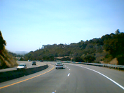 Intended to run from the unconstructed State Route 251, SR 37 begins in Novato with a junction at U.S. Route 101 and heads northeast as a freeway for about a quarter mile before becoming a four-lane expressway. The route passes over the Petaluma River
into Sonoma County before meeting the southern terminus of State Route 121 near Sears Point
(where the Infineon Raceway
is located) at a signal-controlled intersection.
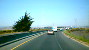
The route continues in a more easterly, then southeasterly, direction as a two-lane highway with a concrete divider (essentially a super two-lane highway
) crossing Tolay Creek
and proceeding through the Napa Sonoma Marsh
at the northern edge of San Pablo Bay
. Before the construction of the barrier in 1995, this portion of SR 37 was three lanes with the middle lane alternately serving as a passing lane for each direction. This stretch of highway was given the nickname of "Blood Alley" for its high-rate of fatal accidents. With the middle lane removed, accidents dropped dramatically, but it is not uncommon for long chains of cars to back up behind slower moving traffic.
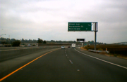
SR 37 becomes a freeway on Mare Island
, approaching northern Vallejo. After it crosses over the Napa River Bridge, it continues as a freeway, overlapping the old highway alignment and passing north of the old road known as Marine World Parkway (due to its proximity to the Six Flags Discovery Kingdom
, previously known as Marine World). SR 37 travels in a northeasterly direction along the White Slough before turning east as it crosses over State Route 29 and heads to its eastern terminus at I-80. In the early 1990s, the stretch between Fairgrounds Drive, which serves as the entrance to Discovery Kingdom, and Mini Drive was upgraded to a freeway. In 2004 and 2005, following over fifty years of complications, the remaining non-freeway section in Vallejo was upgraded as well.
Route 37 is also known as Randy Bolt Memorial Highway from Route 29 to Skaggs Road, and Sears Point Toll Road, which was originally a toll road
that ran from Route 121 to Vallejo. This route is part of the California Freeway and Expressway System
and is eligible for the State Scenic Highway System
. However, it is not designated as a scenic highway by Caltrans.

Soon after, the project was split into different phases to handle problems with particular areas. It was first divided between the newly created marshlands and the section between Sonoma Blvd.
(SR 29) and I-80. With Marine World being relocated, the city was able to the widen the latter section in 1992, as well as upgrade most of it to freeway standards.
 While the Vallejo section of SR 37 was being built, another problem with the route would hinder its progress. The section between Sears Point and Mare Island was plagued with fatal accidents, earning its nickname of "Blood Alley". Between 1966 and 1970, twenty-seven people lost their lives to it. In a preliminary effort to reduce the fatalities, officials established both a daylight test section, requiring all cars to keep their headlights on during the day, and passing lanes. However, these efforts were ineffective.
In 1993, local resident Jim Poulos campaigned to have a barrier erected after the death of his 18 year old son, Frankie, on Blood Alley. At this time, the situation with this stretch only worsened as the death toll between 1990 and 1996 rose to thirty-one. At first, Caltrans thought the barrier would make matters worse since it would be difficult for emergency vehicles to attend to accidents; environmental issues were also cited. Caltrans was waiting for the ability to create a causeway to span the area instead. Poulos continued his campaign despite opposition, and was granted the barrier in 1995. The barrier was not built without controversy, as it also eliminated the passing lanes. However, since the barriers were built, there were no longer any crossover accidents as of 2005.
 While the median was built, a few problems needed to be resolved in order for the road to work both safely and in an environmentally friendly way. Emergency personnel needed to quickly access accidents and provide them easy transport to nearby hospitals. To alleviate this problem, Caltrans implemented new electric gate technology, which would allow emergency vehicles to cut through certain parts of the median. The other problem was to both protect the plant life and the salt harvest mice
which reside around the highway. As a result, crews placed timbers and sheeting to protect foliage, and they added holes into the median barrier to allow the mice to cross the highway.
 With the barrier complete, the focus of improvement changed back to Vallejo. There were still two phases to complete in order for the Vallejo portion of the route to be upgraded to a freeway. The two-lane section of road between Sonoma Blvd. and near the Napa River bridge, which ran through protected wetlands known as the White Slough
, was both prone to flooding and traffic problems. In addition, the junction of Routes 29 and 37 was claimed to be a dangerous intersection. To fix these problems, Vallejo city officials decided to proceed with extending the freeway to Mare Island. After environmental studies on the White Slough, Caltrans widened and elevated that section of the road and converted it to a freeway. To accommodate bicycles and pedestrians, a cycleway
was built along the eastbound side of the freeway. Finally, Caltrans completed the overpass which crossed SR 29, Broadway, and Mini Drive (bypassing Marine World Parkway, three traffic signalled intersections, and a railroad grade crossing). The project was completed in the summer of 2005, and fully open to traffic on August 20, 2005.
{| class=wikitable
!County
!Location
!Postmile
!Exit
!Destinations
!Notes
|-
|rowspan=6|Marin
MRN R11.20-14.62
|rowspan=4|Novato
|R11.20
|
|South Novato Boulevard
|Continuation beyond US 101
|-
|R11.20
|
|
|
|-
|11.50
|
|Marsh Drive, Hanna Ranch Road
|
|-
|colspan=4 align=center|East end of freeway
|-
|
|13.77
|
|Atherton Avenue – Black Point
|
|-
|
|bgcolor=#ffdddd|14.47
|bgcolor=#ffdddd|
|bgcolor=#ffdddd|Harbor Drive
|bgcolor=#ffdddd|Westbound exit and entrance
|-
|rowspan=2|Sonoma
SON 0.00-R6.25
|
|2.06
|
|Lakeville Road
|
|-
|Sears Point
|3.90
|
|
|Serves Infineon Raceway
|-
|rowspan=9|Solano
SOL R0.00-R12.00
|
|
|
|Skaggs Island
|
|-
|colspan=5 align=center|West end of freeway
|-
|rowspan=7|Vallejo
|R7.21
|17
|Mare Island
|
|-
|R7.39
|colspan=3 align=center|Mare Island Bridge over Napa River
|-
|8.01
|18
|Wilson Avenue, Sacramento Street
|Signed as Wilson Avenue eastbound
|-
|9.52
|19
|
|
|-
|10.96
|20
|Fairgrounds Drive – Discovery Kingdom
|
|-
|R12.00
|21
|
|Eastbound exit and westbound entrance; signed as exits 21A (west) and 21C (east)
|-
|R12.00
|21B
|Auto Mall Columbus Parkway
|Eastbound exit and westbound entrance
State highway
State highway, state road or state route can refer to one of three related concepts, two of them related to a state or provincial government in a country that is divided into states or provinces :#A...
in the northern
Northern California
Northern California is the northern portion of the U.S. state of California. The San Francisco Bay Area , and Sacramento as well as its metropolitan area are the main population centers...
part of the U.S. state
U.S. state
A U.S. state is any one of the 50 federated states of the United States of America that share sovereignty with the federal government. Because of this shared sovereignty, an American is a citizen both of the federal entity and of his or her state of domicile. Four states use the official title of...
of California
California
California is a state located on the West Coast of the United States. It is by far the most populous U.S. state, and the third-largest by land area...
that runs 21 miles (34 km) along the northern shore of San Pablo Bay
San Pablo Bay
San Pablo Bay is a tidal estuary that forms the northern extension of San Francisco Bay in northern California in the United States. Most of the Bay is shallow; however, there is a deep water channel approximately in mid bay, which allows access to Sacramento, Stockton, Benicia, Martinez, and...
. It is built from U.S. Route 101 in Novato
Novato, California
Novato is a city located in the North Bay region of the San Francisco Bay Area, in northern Marin County. Novato is located about north-northwest of San Rafael, at an elevation of 30 feet above sea level . The 2010 U.S. Census estimated the city population to be about 51,904. Novato is about ...
and runs through the southern tips of Sonoma
Sonoma County, California
Sonoma County, located on the northern coast of the U.S. state of California, is the largest and northernmost of the nine San Francisco Bay Area counties. Its population at the 2010 census was 483,878. Its largest city and county seat is Santa Rosa....
and Napa
Napa County, California
Napa County is a county located north of the San Francisco Bay Area in the U.S. state of California. It is coterminous with the Napa, California, Metropolitan Statistical Area. As of 2010 the population is 136,484. The county seat is Napa....
Counties to Interstate 80 in Vallejo
Vallejo, California
Vallejo is the largest city in Solano County, California, United States. The population was 115,942 at the 2010 census. It is located in the San Francisco Bay Area on the northeastern shore of San Pablo Bay...
. It serves as a vital connection between the four counties of the North Bay Area
North Bay (San Francisco Bay Area)
The North Bay is a subregion of the San Francisco Bay Area, in California, United States. The largest city is Santa Rosa. It is by far the least populous and least urbanized part of the Bay Area...
, north of San Francisco.
SR 37 has been proposed to be built to freeway standards since the early 1950s. However, the proposal was met with many economic and environmental obstacles, making the task all but impossible for much of the route. Notable problems included a levee break in Vallejo which turned part of the land around the highway into a marsh that is home to endangered species, and a section of highway known as "Blood Alley" for its high-rate of fatal accidents.
Route description
Petaluma River
The Petaluma River is a river in the California counties of Sonoma and Marin that becomes a tidal slough near its mouth. It springs from farmlands southwest of Cotati and flows generally southward through Petaluma's old town and of tidal marshes to end in northwest San Pablo Bay.-History:The word...
into Sonoma County before meeting the southern terminus of State Route 121 near Sears Point
Sears Point
Sears Point is a prominent landform jutting into the historic reaches of San Pablo Bay in Sonoma County, California, USA. This hill is the southernmost peak of the Sonoma Mountains and forms the southwestern ridge above Tolay Lake...
(where the Infineon Raceway
Infineon Raceway
Infineon Raceway, formerly Sears Point Raceway, is a road course and drag strip located on the landform known as Sears Point in the southern Sonoma Mountains near Sonoma, California, USA. The course is a complex series of twists and turns that go up and down the hills...
is located) at a signal-controlled intersection.
The route continues in a more easterly, then southeasterly, direction as a two-lane highway with a concrete divider (essentially a super two-lane highway
Super two
A super two, super two-lane highway or wide two lane is a two-lane surface road built to high standards, typically including partial control of access, occasional passing lanes and hard shoulders...
) crossing Tolay Creek
Tolay Creek
Tolay Creek is a southward-flowing stream in southern Sonoma County, California, USA, which flows through Tolay Lake and ends in north San Pablo Bay.-History:The Alaguali were a Coast Miwok community of northern San Pablo Bay in the Tolay Creek region...
and proceeding through the Napa Sonoma Marsh
Napa Sonoma Marsh
The Napa Sonoma Marsh is a wetland at the northern edge of San Pablo Bay, which is a northern arm of the San Francisco Bay in California, USA. This marsh has an area of 48,000 acres , of which 13,000 acres are abandoned salt evaporation ponds...
at the northern edge of San Pablo Bay
San Pablo Bay
San Pablo Bay is a tidal estuary that forms the northern extension of San Francisco Bay in northern California in the United States. Most of the Bay is shallow; however, there is a deep water channel approximately in mid bay, which allows access to Sacramento, Stockton, Benicia, Martinez, and...
. Before the construction of the barrier in 1995, this portion of SR 37 was three lanes with the middle lane alternately serving as a passing lane for each direction. This stretch of highway was given the nickname of "Blood Alley" for its high-rate of fatal accidents. With the middle lane removed, accidents dropped dramatically, but it is not uncommon for long chains of cars to back up behind slower moving traffic.
SR 37 becomes a freeway on Mare Island
Mare Island
Mare Island is a peninsula in the United States alongside the city of Vallejo, California, about northeast of San Francisco. The Napa River forms its eastern side as it enters the Carquinez Strait juncture with the east side of San Pablo Bay. Mare Island is considered a peninsula because no full...
, approaching northern Vallejo. After it crosses over the Napa River Bridge, it continues as a freeway, overlapping the old highway alignment and passing north of the old road known as Marine World Parkway (due to its proximity to the Six Flags Discovery Kingdom
Six Flags Discovery Kingdom
Six Flags Discovery Kingdom, formerly Six Flags Marine World, Marine World, The New Marine World Theme Park, and Marine World Africa USA, is an animal theme park located in Vallejo, California. The park includes a variety of roller coasters and other amusement rides, along with a collection of...
, previously known as Marine World). SR 37 travels in a northeasterly direction along the White Slough before turning east as it crosses over State Route 29 and heads to its eastern terminus at I-80. In the early 1990s, the stretch between Fairgrounds Drive, which serves as the entrance to Discovery Kingdom, and Mini Drive was upgraded to a freeway. In 2004 and 2005, following over fifty years of complications, the remaining non-freeway section in Vallejo was upgraded as well.
Route 37 is also known as Randy Bolt Memorial Highway from Route 29 to Skaggs Road, and Sears Point Toll Road, which was originally a toll road
Toll road
A toll road is a privately or publicly built road for which a driver pays a toll for use. Structures for which tolls are charged include toll bridges and toll tunnels. Non-toll roads are financed using other sources of revenue, most typically fuel tax or general tax funds...
that ran from Route 121 to Vallejo. This route is part of the California Freeway and Expressway System
California Freeway and Expressway System
The California Freeway and Expressway System is a system of existing or planned freeways and expressways in the U.S. state of California. It is defined by the Streets and Highways Code.-List of roads in the system:*State Route 1 *State Route 2...
and is eligible for the State Scenic Highway System
State Scenic Highway System (California)
The State Scenic Highway System is a list of highways, mainly state highways, that have been designated by the California Department of Transportation as scenic highways. The California State Legislature, primarily through Section 263 of the Streets and Highways Code, makes highways eligible for...
. However, it is not designated as a scenic highway by Caltrans.
History
The whole of SR 37 has been proposed to be built to freeway standards since the early 1950s. However, the proposal was met with many economic and environmental obstacles, making the task all but impossible for much of the route.Plan to widen in Vallejo
The struggle to improve the portion of SR 37 between the Napa River Bridge and I-80 began in 1952, and lasted over fifty years. In 1955, after a proposition to turn much of the route into a toll road failed, it was decided a four-lane freeway would be the best decision. However, opposition from residents in surrounding neighborhoods as well as a federal oil embargo only allowed widening of the approach between Fairgrounds Drive and I-80. In 1977, a levee broke and flooded a portion of the developed land, turning it into protected wetlands with endangered species. Because of its new status, environmental studies were needed in order to continue the project.Soon after, the project was split into different phases to handle problems with particular areas. It was first divided between the newly created marshlands and the section between Sonoma Blvd.
California State Route 29
State Route 29 is a state highway in the U.S. state of California that travels in a north–south direction from State Route 20 in Upper Lake to Interstate 80 in Vallejo.-Route description:...
(SR 29) and I-80. With Marine World being relocated, the city was able to the widen the latter section in 1992, as well as upgrade most of it to freeway standards.
"Blood Alley"
In 1993, local resident Jim Poulos campaigned to have a barrier erected after the death of his 18 year old son, Frankie, on Blood Alley. At this time, the situation with this stretch only worsened as the death toll between 1990 and 1996 rose to thirty-one. At first, Caltrans thought the barrier would make matters worse since it would be difficult for emergency vehicles to attend to accidents; environmental issues were also cited. Caltrans was waiting for the ability to create a causeway to span the area instead. Poulos continued his campaign despite opposition, and was granted the barrier in 1995. The barrier was not built without controversy, as it also eliminated the passing lanes. However, since the barriers were built, there were no longer any crossover accidents as of 2005.
Salt Marsh Harvest Mouse
The Salt Marsh Harvest Mouse , also known as the Red-bellied Harvest Mouse and some times called by Saltmarsh Harvest Mouse, is an endangered rodent endemic to the San Francisco Bay Area salt marshes in California. There are two distinct subspecies, both endangered and listed together on federal...
which reside around the highway. As a result, crews placed timbers and sheeting to protect foliage, and they added holes into the median barrier to allow the mice to cross the highway.
White Slough and Sonoma Blvd. interchange
Swamp
A swamp is a wetland with some flooding of large areas of land by shallow bodies of water. A swamp generally has a large number of hammocks, or dry-land protrusions, covered by aquatic vegetation, or vegetation that tolerates periodical inundation. The two main types of swamp are "true" or swamp...
, was both prone to flooding and traffic problems. In addition, the junction of Routes 29 and 37 was claimed to be a dangerous intersection. To fix these problems, Vallejo city officials decided to proceed with extending the freeway to Mare Island. After environmental studies on the White Slough, Caltrans widened and elevated that section of the road and converted it to a freeway. To accommodate bicycles and pedestrians, a cycleway
Segregated cycle facilities
Segregated cycle facilities are marked lanes, tracks, shoulders and paths designated for use by cyclists from which motorised traffic is generally excluded...
was built along the eastbound side of the freeway. Finally, Caltrans completed the overpass which crossed SR 29, Broadway, and Mini Drive (bypassing Marine World Parkway, three traffic signalled intersections, and a railroad grade crossing). The project was completed in the summer of 2005, and fully open to traffic on August 20, 2005.
Major intersections
- Note: Except where prefixed with a letter, postmiles were measured in 1964, based on the alignment as it existed at that time, and do not necessarily reflect current mileage. The numbers reset at county lines; the start and end postmiles in each county are given in the county column.
{| class=wikitable
!County
!Location
!Postmile
!Exit
Exit number
An exit number is a number assigned to a road junction, usually an exit from a freeway. It is usually marked on the same sign as the destinations of the exit, as well as a sign in the gore....
!Destinations
!Notes
|-
|rowspan=6|Marin
Marin County, California
Marin County is a county located in the North San Francisco Bay Area of the U.S. state of California, across the Golden Gate Bridge from San Francisco. As of 2010, the population was 252,409. The county seat is San Rafael and the largest employer is the county government. Marin County is well...
MRN R11.20-14.62
|rowspan=4|Novato
Novato, California
Novato is a city located in the North Bay region of the San Francisco Bay Area, in northern Marin County. Novato is located about north-northwest of San Rafael, at an elevation of 30 feet above sea level . The 2010 U.S. Census estimated the city population to be about 51,904. Novato is about ...
|R11.20
|
|South Novato Boulevard
|Continuation beyond US 101
|-
|R11.20
|
|
|
|-
|11.50
|
|Marsh Drive, Hanna Ranch Road
|
|-
|colspan=4 align=center|East end of freeway
|-
|
|13.77
|
|Atherton Avenue – Black Point
Black Point, California
Black Point is an unincorporated community in Marin County, California. It is located on the Petaluma River east of downtown Novato, west-northwest of Petaluma Point, at an elevation of 39 feet...
|
|-
|
|bgcolor=#ffdddd|14.47
|bgcolor=#ffdddd|
|bgcolor=#ffdddd|Harbor Drive
|bgcolor=#ffdddd|Westbound exit and entrance
|-
|rowspan=2|Sonoma
Sonoma County, California
Sonoma County, located on the northern coast of the U.S. state of California, is the largest and northernmost of the nine San Francisco Bay Area counties. Its population at the 2010 census was 483,878. Its largest city and county seat is Santa Rosa....
SON 0.00-R6.25
|
|2.06
|
|Lakeville Road
|
|-
|Sears Point
Sears Point
Sears Point is a prominent landform jutting into the historic reaches of San Pablo Bay in Sonoma County, California, USA. This hill is the southernmost peak of the Sonoma Mountains and forms the southwestern ridge above Tolay Lake...
|3.90
|
|
|Serves Infineon Raceway
Infineon Raceway
Infineon Raceway, formerly Sears Point Raceway, is a road course and drag strip located on the landform known as Sears Point in the southern Sonoma Mountains near Sonoma, California, USA. The course is a complex series of twists and turns that go up and down the hills...
|-
|rowspan=9|Solano
Solano County, California
Solano County is a county located in Bay-Delta region of the U.S. state of California, about halfway between San Francisco and Sacramento and is one of the nine San Francisco Bay Area counties. The county's population was reported by the U.S. Census to be 413,344 in 2010...
SOL R0.00-R12.00
|
|
|
|Skaggs Island
|
|-
|colspan=5 align=center|West end of freeway
|-
|rowspan=7|Vallejo
Vallejo, California
Vallejo is the largest city in Solano County, California, United States. The population was 115,942 at the 2010 census. It is located in the San Francisco Bay Area on the northeastern shore of San Pablo Bay...
|R7.21
|17
|Mare Island
Mare Island
Mare Island is a peninsula in the United States alongside the city of Vallejo, California, about northeast of San Francisco. The Napa River forms its eastern side as it enters the Carquinez Strait juncture with the east side of San Pablo Bay. Mare Island is considered a peninsula because no full...
|
|-
|R7.39
|colspan=3 align=center|Mare Island Bridge over Napa River
Napa River
The Napa River, approximately 55 miles long, is a river in the U.S. state of California. It drains a famous wine-growing region, called the Napa Valley, in the mountains northeast of San Francisco. Milliken Creek is a tributary of the Napa River....
|-
|8.01
|18
|Wilson Avenue, Sacramento Street
|Signed as Wilson Avenue eastbound
|-
|9.52
|19
|
|
|-
|10.96
|20
|Fairgrounds Drive – Discovery Kingdom
Six Flags Discovery Kingdom
Six Flags Discovery Kingdom, formerly Six Flags Marine World, Marine World, The New Marine World Theme Park, and Marine World Africa USA, is an animal theme park located in Vallejo, California. The park includes a variety of roller coasters and other amusement rides, along with a collection of...
|
|-
|R12.00
|21
|
|Eastbound exit and westbound entrance; signed as exits 21A (west) and 21C (east)
|-
|R12.00
|21B
|Auto Mall Columbus Parkway
|Eastbound exit and westbound entrance