

Pingo
Encyclopedia
Ice
Ice is water frozen into the solid state. Usually ice is the phase known as ice Ih, which is the most abundant of the varying solid phases on the Earth's surface. It can appear transparent or opaque bluish-white color, depending on the presence of impurities or air inclusions...
found in the Arctic
Arctic
The Arctic is a region located at the northern-most part of the Earth. The Arctic consists of the Arctic Ocean and parts of Canada, Russia, Greenland, the United States, Norway, Sweden, Finland, and Iceland. The Arctic region consists of a vast, ice-covered ocean, surrounded by treeless permafrost...
and subarctic
Subarctic
The Subarctic is a region in the Northern Hemisphere immediately south of the true Arctic and covering much of Alaska, Canada, the north of Scandinavia, Siberia, and northern Mongolia...
that can reach up to 70 metres (229.7 ft) in height and up to 600 m (1,968.5 ft) in diameter. The term originated as the Inuvialuktun
Inuvialuktun
Inuvialuktun, or Western Canadian Inuit language, Western Canadian Inuktitut, Western Canadian Inuktun comprises three Inuit dialects spoken in the northern Northwest Territories by those Canadian Inuit who call themselves Inuvialuk .Inuvialuktun is spoken by the Inuit of the Mackenzie River delta...
word for a small hill. A pingo is a periglacial
Periglacial
Periglacial is an adjective originally referring to places in the edges of glacial areas, but it has later been widely used in geomorphology to describe any place where geomorphic processes related to freezing of water occur...
landform, which is defined as a nonglacial landform or process linked to colder climates. They are essentially formed by ground ice which develops during the winter months as temperatures fall. The plural form is "pingos".
Locations
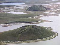
Tuktoyaktuk in the Mackenzie DeltaMackenzie River
The Mackenzie River is the largest river system in Canada. It flows through a vast, isolated region of forest and tundra entirely within the country's Northwest Territories, although its many tributaries reach into four other Canadian provinces and territories...
of the Northwest Territories
Northwest Territories
The Northwest Territories is a federal territory of Canada.Located in northern Canada, the territory borders Canada's two other territories, Yukon to the west and Nunavut to the east, and three provinces: British Columbia to the southwest, and Alberta and Saskatchewan to the south...
has one of the highest concentrations of pingos, with some 1,350 examples. Pingo National Landmark
Pingo National Landmark
Pingo National Landmark is a natural area protecting eight pingos near Tuktoyaktuk, Northwest Territories. It is in a coastal region of the Arctic Ocean which contains approximately 1,350 Arctic ice dome hills—approximately one quarter of the world's pingos.The Landmark comprises an area...
protects eight of these features. Other places with pingos include Nunavut
Nunavut
Nunavut is the largest and newest federal territory of Canada; it was separated officially from the Northwest Territories on April 1, 1999, via the Nunavut Act and the Nunavut Land Claims Agreement Act, though the actual boundaries had been established in 1993...
and Yukon
Yukon
Yukon is the westernmost and smallest of Canada's three federal territories. It was named after the Yukon River. The word Yukon means "Great River" in Gwich’in....
in Canada
Canada
Canada is a North American country consisting of ten provinces and three territories. Located in the northern part of the continent, it extends from the Atlantic Ocean in the east to the Pacific Ocean in the west, and northward into the Arctic Ocean...
, Alaska
Alaska
Alaska is the largest state in the United States by area. It is situated in the northwest extremity of the North American continent, with Canada to the east, the Arctic Ocean to the north, and the Pacific Ocean to the west and south, with Russia further west across the Bering Strait...
in the United States
United States
The United States of America is a federal constitutional republic comprising fifty states and a federal district...
, Greenland
Greenland
Greenland is an autonomous country within the Kingdom of Denmark, located between the Arctic and Atlantic Oceans, east of the Canadian Arctic Archipelago. Though physiographically a part of the continent of North America, Greenland has been politically and culturally associated with Europe for...
, Siberia
Siberia
Siberia is an extensive region constituting almost all of Northern Asia. Comprising the central and eastern portion of the Russian Federation, it was part of the Soviet Union from its beginning, as its predecessor states, the Tsardom of Russia and the Russian Empire, conquered it during the 16th...
, and the Norwegian
Norway
Norway , officially the Kingdom of Norway, is a Nordic unitary constitutional monarchy whose territory comprises the western portion of the Scandinavian Peninsula, Jan Mayen, and the Arctic archipelago of Svalbard and Bouvet Island. Norway has a total area of and a population of about 4.9 million...
island of Spitsbergen
Spitsbergen
Spitsbergen is the largest and only permanently populated island of the Svalbard archipelago in Norway. Constituting the western-most bulk of the archipelago, it borders the Arctic Ocean, the Norwegian Sea and the Greenland Sea...
. Some old pingo ruins can be found in Norfolk
Norfolk
Norfolk is a low-lying county in the East of England. It has borders with Lincolnshire to the west, Cambridgeshire to the west and southwest and Suffolk to the south. Its northern and eastern boundaries are the North Sea coast and to the north-west the county is bordered by The Wash. The county...
, England
England
England is a country that is part of the United Kingdom. It shares land borders with Scotland to the north and Wales to the west; the Irish Sea is to the north west, the Celtic Sea to the south west, with the North Sea to the east and the English Channel to the south separating it from continental...
(in the Breckland
Breckland
The Breckland as a landscape region is an unusual natural habitat of England. It comprises the gorse-covered sandy heath that exists in the north of the county of Suffolk and the south of Norfolk. An area of considerable interest for its unusual flora and fauna, it lies to the south east of another...
) and in the Netherlands
Netherlands
The Netherlands is a constituent country of the Kingdom of the Netherlands, located mainly in North-West Europe and with several islands in the Caribbean. Mainland Netherlands borders the North Sea to the north and west, Belgium to the south, and Germany to the east, and shares maritime borders...
, in Dantumadeel
Dantumadeel
Dantumadiel is a municipality in the province of Friesland in the Netherlands. Dantumadiel is a rural municipality characterized by agriculture.- History :...
and Opsterland
Opsterland
Opsterland is a municipality in the province of Friesland in the Netherlands.-Population centres:Bakkeveen, Beetsterzwaag, Frieschepalen, Gorredijk, Hemrik, Jonkerslân, Langezwaag, Lippenhuizen, Luxwoude, Nij Beets, Olterterp, Siegerswoude, Terwispel, Tijnje, Ureterp, Wijnjewoude.-Twin towns —...
in the province of Friesland
Friesland
Friesland is a province in the north of the Netherlands and part of the ancient region of Frisia.Until the end of 1996, the province bore Friesland as its official name. In 1997 this Dutch name lost its official status to the Frisian Fryslân...
, and also in the provinces of Drenthe
Drenthe
Drenthe is a province of the Netherlands, located in the north-east of the country. The capital city is Assen. It is bordered by Overijssel to the south, Friesland to the west, Groningen to the north, and Germany to the east.-History:Drenthe, unlike many other parts of the Netherlands, has been a...
and Groningen
Groningen (province)
Groningen [] is the northeasternmost province of the Netherlands. In the east it borders the German state of Niedersachsen , in the south Drenthe, in the west Friesland and in the north the Wadden Sea...
.
In Siberia, pingos are known as bulganniakh, from the Sakha language
Sakha language
Sakha, or Yakut, is a Turkic language with around 360,000 native speakers spoken in the Sakha Republic in the Russian Federation by the Sakha or Yakuts.Sakha is an agglutinative language, and it employs vowel harmony.-Classification:...
(Yakut language).
Types
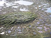
Rounded tops are common for smaller pingos, but larger ones often have breaks in the ice at the top. These larger pingos can have craters that have cones resembling those from volcanoVolcano
2. Bedrock3. Conduit 4. Base5. Sill6. Dike7. Layers of ash emitted by the volcano8. Flank| 9. Layers of lava emitted by the volcano10. Throat11. Parasitic cone12. Lava flow13. Vent14. Crater15...
es. This is due to the ice breaking and from melting of the inner ice core. Beds will often dip outward from the center when they occur in stratified sand or silt, a lot like being adjacent to an intrusive body. Pingos that form in bedrock
Bedrock
In stratigraphy, bedrock is the native consolidated rock underlying the surface of a terrestrial planet, usually the Earth. Above the bedrock is usually an area of broken and weathered unconsolidated rock in the basal subsoil...
can show similar deformation. The ice in the core of pingos usually originates from segregation or injection of fluid water, and can be massive. Tension fractures are normal for the mound's summit, but pingo ice expansion is brief and rare. A small freshwater lake can occupy the summit where a crater has formed from the ice melting.
Pingos are generally classified as hydrostatic (closed-system) or hydraulic (open-system). Relict hydrostatic (closed-system) and hydraulic (open-system) pingos may be distinguished from each other by determining if lacustrine (lake) deposits are associated with the formation.
Formation
Pingos can only form in a permafrostPermafrost
In geology, permafrost, cryotic soil or permafrost soil is soil at or below the freezing point of water for two or more years. Ice is not always present, as may be in the case of nonporous bedrock, but it frequently occurs and it may be in amounts exceeding the potential hydraulic saturation of...
environment. Evidence of collapsed pingos in an area suggests that there was once permafrost.
Pingos usually grow only a couple centimetres per year, with Ibyuk Pingo growing at a rate of 2 centimetre (0.78740157480315 in) a year, and the largest take decades or even centuries to form. The process that creates pingos is believed to be closely related to frost heaving
Frost heaving
Frost heaving results from ice forming beneath the surface of soil during freezing conditions in the atmosphere. The ice grows in the direction of heat loss , starting at the freezing front or boundary in the soil...
.
Hydrostatic (closed-system) pingos form as a result of hydrostatic pressure on water from permafrost, and commonly form in drained lakes or river channels. Permafrost rises to the drained body's former floor. Pore water is expelled in front of the rising permafrost, and the resulting pressure causes the frozen ground to rise and an ice core to form. The shape and size of a hydrostatic or closed system pingo is often similar to the body of water that it originated from. They can vary from symmetrical conical domes to asymmetric, elongate hills.
Hydraulic (open-system) pingos result from groundwater flowing from an outside source, i.e. subpermafrost or intrapermafrost aquifer
Aquifer
An aquifer is a wet underground layer of water-bearing permeable rock or unconsolidated materials from which groundwater can be usefully extracted using a water well. The study of water flow in aquifers and the characterization of aquifers is called hydrogeology...
s. Hydrostatic pressure initializes the formation of the ice core as water is pushed up and subsequently freezes. Open-system pingos have no limitations to the amount of water available unless the aquifers freeze. They often occur at the base of slopes and are commonly known as Greenland type. The groundwater
Groundwater
Groundwater is water located beneath the ground surface in soil pore spaces and in the fractures of rock formations. A unit of rock or an unconsolidated deposit is called an aquifer when it can yield a usable quantity of water. The depth at which soil pore spaces or fractures and voids in rock...
is put under artesian
Artesian aquifer
An artesian aquifer is a confined aquifer containing groundwater under positive pressure. This causes the water level in a well to rise to a point where hydrostatic equilibrium has been reached. This type of well is called an artesian well...
pressure and forces the ground up as it makes an expanding ice core. It is not the artesian
Artesian aquifer
An artesian aquifer is a confined aquifer containing groundwater under positive pressure. This causes the water level in a well to rise to a point where hydrostatic equilibrium has been reached. This type of well is called an artesian well...
pressure itself that forces the ground up, but rather the ice core that is being fed the water from the aquifer. These are often formed in a thin, discontinuous permafrost. These conditions allow an ice core to form, but also provide it with a supply of artesian ground water. These pingos are often oval or oblong shaped. It is still not entirely understood why open system or hydraulic pingos normally occur in unglaciated terrain.
History
The term pingo was first borrowed from the InuvialuitInuvialuit
The Inuvialuit or Western Canadian Inuit are Inuit people who live in the western Canadian Arctic region. They, like all other Inuit, are descendants of the Thule who migrated eastward from Alaska...
by the Arctic botanist Alf Erling Porsild
Erling Porsild
-Biography:He was born in Copenhagen as a son of the botanist M.P. Porsild. He grew up on the Arctic Station in Qeqertarsuaq, West Greenland, where he acted as assistant to his father. Between 1936-1945, he was curator at the National Museum of Canada, Ottawa, and from 1945 to 1967 he was head of...
in 1938. Porsild Pingo in Tuktoyaktuk is named in his honor.
See also
- Frost heavingFrost heavingFrost heaving results from ice forming beneath the surface of soil during freezing conditions in the atmosphere. The ice grows in the direction of heat loss , starting at the freezing front or boundary in the soil...
- PalsaPalsathumb|right|300px|A group of well developed palsas as seen from abovePalsas are low, often oval, frost heaves occurring in polar and subpolar climates, which contain permanently frozen ice lenses...
, a low oval elevation in areas with permafrostPermafrostIn geology, permafrost, cryotic soil or permafrost soil is soil at or below the freezing point of water for two or more years. Ice is not always present, as may be in the case of nonporous bedrock, but it frequently occurs and it may be in amounts exceeding the potential hydraulic saturation of...
, frequently peat bogs, where a perennial ice lens has developed within the soil.