
Pei Xiu
Encyclopedia
Pei Xiu style name
Jiyan (季彥), was a minister, geographer
, and cartographer
of the state of Cao Wei
during the Three Kingdoms
period of Chinese history
, as well as the subsequent Jin Dynasty
. Pei Xiu was very much trusted by Sima Zhao
, and participated in the suppression of Zhuge Dan
's coup. Following Sima Yan taking the throne of the newly established Jin Dynasty, he and Jia Chong
had Cao Huang deprived of his position to accord to the will of heaven. In the year 267, Pei was appointed as the Minister of Works for the Jin Dynasty.
Pei Xiu outlined and analyzed the advancements of cartography
, surveying
, and mathematics
up until his time. He criticized earlier Han Dynasty maps for their lack of precision and quality when representing scale and measured distances, although 20th century archeological excavations and findings of maps predating the 3rd century prove otherwise. There is also evidence that Zhang Heng
(78–139 AD) was the first to establish the grid reference system in Chinese cartography.
 Pei is best known for his work in cartography
. Although professional map-making and use of the grid had existed in China before him, he was the first to mention a plotted geometrical grid reference
and graduated scale displayed on the surface of maps to gain greater accuracy in the estimated distance between different locations. Historian Howard Nelson asserts that there is ample written evidence that Pei Xiu derived the idea of the grid reference from the map of Zhang Heng
(78–139 AD), a polymath inventor and statesman of the Eastern Han period. Robert Temple asserts that Zhang should also be credited as the first to establish the mathematical grid in cartography, as evidenced by his work in maps, the titles of his lost books, and the hint given in the Book of Later Han
(i.e. Zhang "cast a network of coordinates about heaven and earth, and reckoned on the basis of it").
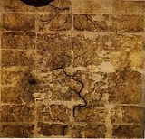
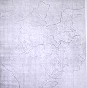
The preface to Pei Xiu's written work was preserved in the 35th chapter of the Jin Shu, which is the official history for the Jin Dynasty and one of the Twenty-four Histories
. It was written in the Jin Shu that Pei made a critical study of ancient texts in order to update the naming conventions of geographic locations described in old texts. His maps —drawn upon rolls of silk — were presented to the Jin emperor, who preserved them in the court's archives. Pei Xiu's maps have since been lost, decayed, or destroyed. Yet the oldest existing terrain maps from China date to the 4th century BC, found in a Qin State
tomb of modern Gansu
province in 1986. Han Dynasty
era maps from the 2nd century BC were found earlier in the 1973 excavation of Mawangdui.
In 1697, the Qing Dynasty
cartographer Hu Wei reconstructed Pei's maps in his Yugong Zhuizhui (A Few Points in the Vast Subject of the Yu Gong). Modern scholars have also used Pei's writing to reproduce his works, and historians such as Herrmann have compared Pei to other great ancient cartographers such as the Greek
cartographer Ptolemy
(83–161).
 Pei Xiu wrote a preface to his maps with essential background information regarding older maps in China. Pei Xiu also provided a great deal of criticism about the existing maps from the Han Dynasty in his time. Later Chinese ideas about the quality of maps made during the Han Dynasty and before stem from the assessment given by Pei Xiu, which was not a positive one. Pei Xiu noted that the extant Han maps at his disposal were of little use since they featured too many inaccuracies and exaggerations in measured distance between locations. However, the Qin State maps and Mawangdui maps of the Han Dynasty discovered by modern archeologists were far superior in quality than those examined and criticized by Pei Xiu. It was not until the 20th century that Pei Xiu's 3rd century assessment of earlier maps' dismal quality would be overturned and disproven. The makers of the Han maps were familiar with the use of scale, while the Qin map makers had pinpointed the course of rivers with some accuracy. What these earlier maps did not feature was topographical elevation
, which Pei Xiu would outline with his six principles of cartography.
Pei Xiu's preface describes geographers in the Xia
, Shang
, and Zhou
dynasties, although the earliest known geographical work was the Yu Gong chapter of the Classic of History
, compiled in the 5th century BC during the mid Zhou period. Pei also referred to the officer Xiao He
(d. 193), who assembled the maps made during the recently fallen Qin Dynasty
. This was done after the founder of the Han Dynasty
, Liu Bang (d. 195 BC) had sacked the city of Xianyang
. Pei Xiu states:
Pei Xiu continues his preface with short background information on the conquest of the Jin Dynasty and the impressive maps commissioned by Emperor Wen of Jin, otherwise known as Sima Zhao
(211–264). He then described the methods he used to create new maps while examining the ancient Yu Gong text to create historical maps:
Pei Xiu outlined six principles that should be observed when creating a map. He then defended his position and each of the six principles with a short explanation as to how they provide better accuracy in map-making and cartography. The first three principles outlined the use of scale (fan lu), direction (zhunwang), and road distance (daoli), while the last three principles are used to properly calculate distances on uneven terrain as represented on a flat, two dimensional map. Pei Xiu states:
Chinese style name
A Chinese style name, sometimes also known as a courtesy name , is a given name to be used later in life. After 20 years of age, the zì is assigned in place of one's given name as a symbol of adulthood and respect...
Jiyan (季彥), was a minister, geographer
History of geography
The history of geography includes various histories of geography which have differed over time and between different cultural and political groups. In more recent developments, geography has become a distinct academic discipline. 'Geography' derives from the from Greek - geographia,, a literal...
, and cartographer
History of cartography
Cartography , or mapmaking, has been an integral part of the human story for a long time, possibly up to 8,000 years...
of the state of Cao Wei
Cao Wei
Cao Wei was one of the states that competed for control of China during the Three Kingdoms period. With the capital at Luoyang, the state was established by Cao Pi in 220, based upon the foundations that his father Cao Cao laid...
during the Three Kingdoms
Three Kingdoms
The Three Kingdoms period was a period in Chinese history, part of an era of disunity called the "Six Dynasties" following immediately the loss of de facto power of the Han Dynasty rulers. In a strict academic sense it refers to the period between the foundation of the state of Wei in 220 and the...
period of Chinese history
History of China
Chinese civilization originated in various regional centers along both the Yellow River and the Yangtze River valleys in the Neolithic era, but the Yellow River is said to be the Cradle of Chinese Civilization. With thousands of years of continuous history, China is one of the world's oldest...
, as well as the subsequent Jin Dynasty
Jìn Dynasty (265-420)
The Jìn Dynasty , was a dynasty in Chinese history, lasting between the years 265 and 420 AD. There are two main divisions in the history of the Dynasty, the first being Western Jin and the second Eastern Jin...
. Pei Xiu was very much trusted by Sima Zhao
Sima Zhao
Sima Zhao was a military general, politician and regent of the state of Cao Wei during the Three Kingdoms period of Chinese history...
, and participated in the suppression of Zhuge Dan
Zhuge Dan
Zhuge Dan , style named Gongxiu , was a military general of Cao Wei during the Three Kingdoms period of Chinese history. When he held military positions during his middle to late career, he got involved in all Three Rebellions in Shouchun, which aimed to drive the de facto ruler of Cao Wei, Sima...
's coup. Following Sima Yan taking the throne of the newly established Jin Dynasty, he and Jia Chong
Jia Chong
Jia Chong , style name Gonglü , formally known as Duke Wu of Lu , was an official of the Jin Dynasty period of Chinese history...
had Cao Huang deprived of his position to accord to the will of heaven. In the year 267, Pei was appointed as the Minister of Works for the Jin Dynasty.
Pei Xiu outlined and analyzed the advancements of cartography
Cartography
Cartography is the study and practice of making maps. Combining science, aesthetics, and technique, cartography builds on the premise that reality can be modeled in ways that communicate spatial information effectively.The fundamental problems of traditional cartography are to:*Set the map's...
, surveying
Surveying
See Also: Public Land Survey SystemSurveying or land surveying is the technique, profession, and science of accurately determining the terrestrial or three-dimensional position of points and the distances and angles between them...
, and mathematics
Chinese mathematics
Mathematics in China emerged independently by the 11th century BC. The Chinese independently developed very large and negative numbers, decimals, a place value decimal system, a binary system, algebra, geometry, and trigonometry....
up until his time. He criticized earlier Han Dynasty maps for their lack of precision and quality when representing scale and measured distances, although 20th century archeological excavations and findings of maps predating the 3rd century prove otherwise. There is also evidence that Zhang Heng
Zhang Heng
Zhang Heng was a Chinese astronomer, mathematician, inventor, geographer, cartographer, artist, poet, statesman, and literary scholar from Nanyang, Henan. He lived during the Eastern Han Dynasty of China. He was educated in the capital cities of Luoyang and Chang'an, and began his career as a...
(78–139 AD) was the first to establish the grid reference system in Chinese cartography.
Pei Xiu the cartographer
Cartography
Cartography is the study and practice of making maps. Combining science, aesthetics, and technique, cartography builds on the premise that reality can be modeled in ways that communicate spatial information effectively.The fundamental problems of traditional cartography are to:*Set the map's...
. Although professional map-making and use of the grid had existed in China before him, he was the first to mention a plotted geometrical grid reference
Grid reference
Grid references define locations on maps using Cartesian coordinates. Grid lines on maps define the coordinate system, and are numbered to provide a unique reference to features....
and graduated scale displayed on the surface of maps to gain greater accuracy in the estimated distance between different locations. Historian Howard Nelson asserts that there is ample written evidence that Pei Xiu derived the idea of the grid reference from the map of Zhang Heng
Zhang Heng
Zhang Heng was a Chinese astronomer, mathematician, inventor, geographer, cartographer, artist, poet, statesman, and literary scholar from Nanyang, Henan. He lived during the Eastern Han Dynasty of China. He was educated in the capital cities of Luoyang and Chang'an, and began his career as a...
(78–139 AD), a polymath inventor and statesman of the Eastern Han period. Robert Temple asserts that Zhang should also be credited as the first to establish the mathematical grid in cartography, as evidenced by his work in maps, the titles of his lost books, and the hint given in the Book of Later Han
Book of Later Han
The Book of the Later Han or the History of the Later Han is one of the official Chinese historical works which was compiled by Fan Ye in the 5th century, using a number of earlier histories and documents as sources...
(i.e. Zhang "cast a network of coordinates about heaven and earth, and reckoned on the basis of it").
The preface to Pei Xiu's written work was preserved in the 35th chapter of the Jin Shu, which is the official history for the Jin Dynasty and one of the Twenty-four Histories
Twenty-Four Histories
The Twenty-Four Histories is a collection of Chinese historical books covering a period from 3000 BC to the Ming Dynasty in the 17th century. The whole set contains 3213 volumes and about 40 million words...
. It was written in the Jin Shu that Pei made a critical study of ancient texts in order to update the naming conventions of geographic locations described in old texts. His maps —drawn upon rolls of silk — were presented to the Jin emperor, who preserved them in the court's archives. Pei Xiu's maps have since been lost, decayed, or destroyed. Yet the oldest existing terrain maps from China date to the 4th century BC, found in a Qin State
Qin (state)
The State of Qin was a Chinese feudal state that existed during the Spring and Autumn and Warring States Periods of Chinese history...
tomb of modern Gansu
Gansu
' is a province located in the northwest of the People's Republic of China.It lies between the Tibetan and Huangtu plateaus, and borders Mongolia, Inner Mongolia, and Ningxia to the north, Xinjiang and Qinghai to the west, Sichuan to the south, and Shaanxi to the east...
province in 1986. Han Dynasty
Han Dynasty
The Han Dynasty was the second imperial dynasty of China, preceded by the Qin Dynasty and succeeded by the Three Kingdoms . It was founded by the rebel leader Liu Bang, known posthumously as Emperor Gaozu of Han. It was briefly interrupted by the Xin Dynasty of the former regent Wang Mang...
era maps from the 2nd century BC were found earlier in the 1973 excavation of Mawangdui.
In 1697, the Qing Dynasty
Qing Dynasty
The Qing Dynasty was the last dynasty of China, ruling from 1644 to 1912 with a brief, abortive restoration in 1917. It was preceded by the Ming Dynasty and followed by the Republic of China....
cartographer Hu Wei reconstructed Pei's maps in his Yugong Zhuizhui (A Few Points in the Vast Subject of the Yu Gong). Modern scholars have also used Pei's writing to reproduce his works, and historians such as Herrmann have compared Pei to other great ancient cartographers such as the Greek
Roman Greece
Roman Greece is the period of Greek history following the Roman victory over the Corinthians at the Battle of Corinth in 146 BC until the reestablishment of the city of Byzantium and the naming of the city by the Emperor Constantine as the capital of the Roman Empire...
cartographer Ptolemy
Ptolemy
Claudius Ptolemy , was a Roman citizen of Egypt who wrote in Greek. He was a mathematician, astronomer, geographer, astrologer, and poet of a single epigram in the Greek Anthology. He lived in Egypt under Roman rule, and is believed to have been born in the town of Ptolemais Hermiou in the...
(83–161).
Pei's written work
Elevation
The elevation of a geographic location is its height above a fixed reference point, most commonly a reference geoid, a mathematical model of the Earth's sea level as an equipotential gravitational surface ....
, which Pei Xiu would outline with his six principles of cartography.
Pei Xiu's preface describes geographers in the Xia
Xia Dynasty
The Xia Dynasty is the first dynasty in China to be described in ancient historical chronicles such as Bamboo Annals, Classic of History and Records of the Grand Historian. The Xia Dynasty was established by the legendary Yu the Great after Shun, the last of the Five Emperors gave his throne to him...
, Shang
Shang Dynasty
The Shang Dynasty or Yin Dynasty was, according to traditional sources, the second Chinese dynasty, after the Xia. They ruled in the northeastern regions of the area known as "China proper" in the Yellow River valley...
, and Zhou
Zhou Dynasty
The Zhou Dynasty was a Chinese dynasty that followed the Shang Dynasty and preceded the Qin Dynasty. Although the Zhou Dynasty lasted longer than any other dynasty in Chinese history, the actual political and military control of China by the Ji family lasted only until 771 BC, a period known as...
dynasties, although the earliest known geographical work was the Yu Gong chapter of the Classic of History
Classic of History
The Classic of History is a compilation of documentary records related to events in ancient history of China. It is also commonly known as the Shàngshū , or simply Shū...
, compiled in the 5th century BC during the mid Zhou period. Pei also referred to the officer Xiao He
Xiao He
Xiao He was a Chinese statesman who lived during the early Han Dynasty. He served Liu Bang during the insurrection against the Qin Dynasty, and fought on Liu's side in the Chu–Han contention against Xiang Yu. After the founding of the Han Dynasty, Xiao He became chancellor and held office until...
(d. 193), who assembled the maps made during the recently fallen Qin Dynasty
Qin Dynasty
The Qin Dynasty was the first imperial dynasty of China, lasting from 221 to 207 BC. The Qin state derived its name from its heartland of Qin, in modern-day Shaanxi. The strength of the Qin state was greatly increased by the legalist reforms of Shang Yang in the 4th century BC, during the Warring...
. This was done after the founder of the Han Dynasty
Han Dynasty
The Han Dynasty was the second imperial dynasty of China, preceded by the Qin Dynasty and succeeded by the Three Kingdoms . It was founded by the rebel leader Liu Bang, known posthumously as Emperor Gaozu of Han. It was briefly interrupted by the Xin Dynasty of the former regent Wang Mang...
, Liu Bang (d. 195 BC) had sacked the city of Xianyang
Xianyang
Xianyang is a former capital of China in Shaanxi province, on the Wei River, a few kilometers upstream from Xi'an. It has an area of...
. Pei Xiu states:
The origin of maps and geographical treatises goes back into former ages. Under the three dynasties (Xia, Shang, and Zhou) there were special officials for this (Guo Shi). Then, when the Han people sacked Xianyang, Xiao He collected all the maps and documents of the Qin. Now it is no longer possible to find the old maps in the secret archives, and even those Xiao He found are missing. We only have maps, both general and local, from the (Later) Han time. None of these employs a graduated scale (fen lü) and none of them are arranged on a rectangular grid (zhun wang). Moreover, none of them gives anything like a complete representation of the celebrated mountains and the great rivers; their arrangement is very rough and imperfect, and one cannot rely on them. Indeed some of them contain absurdities, irrelevancies, and exaggerations, which are not in accord with reality, and which should be banished by good sense.
Pei Xiu continues his preface with short background information on the conquest of the Jin Dynasty and the impressive maps commissioned by Emperor Wen of Jin, otherwise known as Sima Zhao
Sima Zhao
Sima Zhao was a military general, politician and regent of the state of Cao Wei during the Three Kingdoms period of Chinese history...
(211–264). He then described the methods he used to create new maps while examining the ancient Yu Gong text to create historical maps:
The assumption of power by the great Jin dynasty has unified space in all the six directions. To purify its territory, it began with Yong and Shu (Hubei and Sichuan), and penetrated deeply into their regions, though full of obstacles. The emperor Wen then ordered the appropriate officials to draw up maps of Wu and Shu. After Shu had been conquered and the maps were examined, with regard to the distances from one another of mountains, rivers, and places, the positions of plains and declivities, and the lines of the roads, whether straight or curved, which the six armies had followed; it was found that there was not the slightest error. Now, referring back to antiquity, I have examined according to the Yu Gong the mountains and lakes, the courses of the rivers, the plateaus and plains, the slopes and marshes, the limits of the nine ancient provinces and the sixteen modern ones, taking account of commanderies and fiefs, prefectures and cities, and not forgetting the names of places where the ancient kingdoms concluded treaties or held meetings; and lastly, inserting the roads, paths, and navigable waters, I have made this map in eighteen sheets.
Pei Xiu outlined six principles that should be observed when creating a map. He then defended his position and each of the six principles with a short explanation as to how they provide better accuracy in map-making and cartography. The first three principles outlined the use of scale (fan lu), direction (zhunwang), and road distance (daoli), while the last three principles are used to properly calculate distances on uneven terrain as represented on a flat, two dimensional map. Pei Xiu states:
In making a map there are six observable principles: (1) the graduated divisions, which are the means of determining the map's scale; (2) the rectangular grid (of parallel lines in two dimensions), which is the way of depicting correct relations between various parts of the map; (3) pacing out the sides of right-angled triangles, which is the way of fixing the lengths of derived distances (i.e., the third side of the triangle, which cannot be walked over); (4) (measuring) the high and the low; (5) (measuring) right angles and acute angles; (6) (measuring) curves and straight lines. These three principles are used according to the nature of the terrain, and are the means by which one reduces what are really plains and hills (lit. cliffs) to distances on a plane surface...If one draws a map without graduated divisions, there is no means of distinguishing between what is near and what is far. If one has graduated divisions, but no rectangular grid or network of lines, then while one may attain accuracy in one corner of the map, one will certainly lose it elsewhere (i.e. in the middle, far from guiding marks). If one has a rectangular grid, but has not worked upon the [third] principle, then when it is a case of places in difficult country, among mountains, lakes, or seas (which cannot be traversed directly by the surveyor), one cannot ascertain how they are related to one another. If one has adopted the [third] principle, but has not taken account of the high and the low, the right angles and acute angles, and the curves and straight lines, then the figures for distances indicated on the paths and roads will be far from the truth, and one will lose the accuracy of the rectangular grid. However, if we examine a map prepared by the combination of all these principles, we find that a true scale representation of the distances is fixed by the graduated divisions. So also the reality of the relative positions is attained by the use of paced sides of right-angled triangles; and the true scale of degrees and figures is reproduced by the determinations of high and low, angular dimensions, and curved or straight lines. Thus even if there are great obstacles in the shape of high mountains or vast lakes, huge distances or strange places, necessitating climbs and descents, retracting of steps or detours — everything can be taken into account and determined. When the principle of the rectangular grid is properly applied, then the straight and the curved, near and the far, can conceal nothing of their form from us.