

PAVE PAWS
Encyclopedia
United States
The United States of America is a federal constitutional republic comprising fifty states and a federal district...
Air Force Space Command
Air Force Space Command
Air Force Space Command is a major command of the United States Department of the Air Force, with its headquarters at Peterson Air Force Base, Colorado. AFSPC supports U.S. military operations worldwide through the use of many different types of satellite, launch and cyber operations....
radar
Radar
Radar is an object-detection system which uses radio waves to determine the range, altitude, direction, or speed of objects. It can be used to detect aircraft, ships, spacecraft, guided missiles, motor vehicles, weather formations, and terrain. The radar dish or antenna transmits pulses of radio...
system operated by three 21st Space Wing
21st Space Wing
The 21st Space Wing is a unit of the Air Force Space Command based at Peterson Air Force Base, Colorado. The unit is tasked with the operation of early missile warning and space object detection equipment around the world in support of NORAD and USSTRATCOM through a network of command and control...
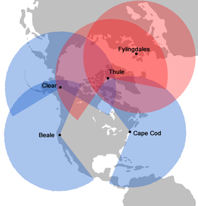
squadrons for missile warning and space surveillance. Operational PAVE PAWS radars are located at:
- Cape Cod Air Force StationCape Cod Air Force StationCape Cod Air Force Station is a US Air Force station located in the northwest corner of the Massachusetts Military Reservation, USA, on Flatrock Hill...
, MassachusettsMassachusettsThe Commonwealth of Massachusetts is a state in the New England region of the northeastern United States of America. It is bordered by Rhode Island and Connecticut to the south, New York to the west, and Vermont and New Hampshire to the north; at its east lies the Atlantic Ocean. As of the 2010...
. Operated by 6th Space Warning Squadron, (41°45′08"N 70°32′17"W) - Beale AFBBeale Air Force BaseBeale Air Force Base is a United States Air Force base located approximately east of Marysville, California. Originally known as Camp Beale....
, CaliforniaCaliforniaCalifornia is a state located on the West Coast of the United States. It is by far the most populous U.S. state, and the third-largest by land area...
. Operated by 7th Space Warning Squadron, (39°08′10"N 121°21′03"W) - Clear Air Force StationClear Air Force StationClear Air Force Station is a United States Air Force Station located 5 miles south of Anderson, Alaska, USA, northeast of Mount McKinley, and southwest of Fairbanks. Its primary mission is to detect incoming ICBMs and submarine-launched ballistic missiles.-Overview:Clear AFS is operated by the...
, AlaskaAlaskaAlaska is the largest state in the United States by area. It is situated in the northwest extremity of the North American continent, with Canada to the east, the Arctic Ocean to the north, and the Pacific Ocean to the west and south, with Russia further west across the Bering Strait...
. Operated by 13th Space Warning Squadron, (64°18′01"N 149°11′23"W). Scheduled to become a PAVE PAWS site from being a BMEWS site in 2001.
In addition, two other facilities were shuttered by the Air Force in 1995: Robins Air Force Base
Robins Air Force Base
Robins Air Force Base is a major United States Air Force base located in Houston County, Georgia, United States. The base is located just east of and adjacent to the city of Warner Robins, Georgia, SSE of Macon, Georgia, and about SSE of Atlanta, Georgia...
, Warner Robins, Georgia (32°34′52"N 83°34′09"W), and Eldorado AFS, Texas
Texas
Texas is the second largest U.S. state by both area and population, and the largest state by area in the contiguous United States.The name, based on the Caddo word "Tejas" meaning "friends" or "allies", was applied by the Spanish to the Caddo themselves and to the region of their settlement in...
(30.979°N 100.554°W).
PAVE
PAVE
The codeword PAVE is a U.S. Air Force program identifier relating to electronic systems. Use of the prefix identifier is sometimes thought to be an acronym, but the various acronyms proposed do not fit with the wide range of programs it is used to identify...
is an Air Force program name relating to electronic systems, while PAWS stands for Phased Array Warning System. PAVE has also been defined as an acronym for Precision Acquisition Vehicle Entry, but that is likely a backronym
Backronym
A backronym or bacronym is a phrase constructed purposely, such that an acronym can be formed to a specific desired word. Backronyms may be invented with serious or humorous intent, or may be a type of false or folk etymology....
created to explain the program name. The radar, developed by Raytheon
Raytheon
Raytheon Company is a major American defense contractor and industrial corporation with core manufacturing concentrations in weapons and military and commercial electronics. It was previously involved in corporate and special-mission aircraft until early 2007...
, is used primarily to detect and track sea-launched (SLBM) and intercontinental
Intercontinental ballistic missile
An intercontinental ballistic missile is a ballistic missile with a long range typically designed for nuclear weapons delivery...
ballistic missile
Ballistic missile
A ballistic missile is a missile that follows a sub-orbital ballistic flightpath with the objective of delivering one or more warheads to a predetermined target. The missile is only guided during the relatively brief initial powered phase of flight and its course is subsequently governed by the...
s (ICBMs).
The system also has a secondary mission of detecting and tracking Earth-orbiting satellites. Information received from the PAVE PAWS radar systems pertaining to SLBM/ICBM and satellite detection is forwarded to the U.S. Strategic Command’s Missile Correlation (formerly Missile Warning) and Space Control Centers at Cheyenne Mountain Air Station, Colorado
Colorado
Colorado is a U.S. state that encompasses much of the Rocky Mountains as well as the northeastern portion of the Colorado Plateau and the western edge of the Great Plains...
. Data is also sent to the National Military Command Center and to U.S. Strategic Command's Command Center at Offutt AFB, Nebraska.
Features

Phased array
In wave theory, a phased array is an array of antennas in which the relative phases of the respective signals feeding the antennas are varied in such a way that the effective radiation pattern of the array is reinforced in a desired direction and suppressed in undesired directions.An antenna array...
antenna technology which is now common in defence applications. This system differs from a mechanical radar, which must be physically aimed at an object in space to detect and/or track it. The phased array antenna is in a fixed position and can be part of the building wall. Phased array antenna aiming, or beam steering, is done rapidly by electronically controlling the timing (the phase
Phase (waves)
Phase in waves is the fraction of a wave cycle which has elapsed relative to an arbitrary point.-Formula:The phase of an oscillation or wave refers to a sinusoidal function such as the following:...
) of the incoming and outgoing signals. Controlling the phase through the many segments of the antenna system allows the beam to be quickly projected in different directions. This greatly reduces the time necessary to change the beam direction from one point to another, allowing almost simultaneous tracking of multiple targets while maintaining the surveillance responsibility. This ability is known as "track while scan".
The large fixed antenna array through its better beam focusing, improves system sensitivity and tracking accuracy.
Phased array radars are also commonly found on U.S. Navy ships (the Aegis
Aegis combat system
The Aegis Combat System is an integrated naval weapons system developed by the Missile and Surface Radar Division of RCA, and now produced by Lockheed Martin...
system), and in the U.S. Army's Patriot
MIM-104 Patriot
The MIM-104 Patriot is a surface-to-air missile system, the primary of its kind used by the United States Army and several allied nations. It is manufactured by the Raytheon Company of the United States. The Patriot System replaced the Nike Hercules system as the U.S. Army's primary High to Medium...
air defense missile system.
Background

- Section source: Fact Sheet
A phased array antenna, as with any other directional antenna, will receive signals from space only in the direction in which the beam is aimed. The maximum practical deflection on either side of antenna center of the phased array beam is 60 degrees. This limits the coverage from a single antenna face to 120 degrees. To provide surveillance across the horizon, the building housing the entire system and supporting the antenna arrays is constructed in the shape of a triangle. The two building faces supporting the arrays, each covering 120 degrees, will monitor 240 degrees of azimuth. The array faces are also tilted back 20 degrees to allow for an elevations deflection from three to 85 degrees above horizontal. The radar system is capable of detecting and monitoring a great number of targets that would be consistent with a massive SLBM attack. The system must rapidly discriminate between vehicle types, calculating their launch and impact points in addition to the scheduling, data processing and communications requirements. The operation is entirely automatic, requiring people only for monitoring, maintenance and as a final check of the validity of warnings. Three different computers communicate with each other from the heart of the system, which relays the information to Cheyenne Mountain AS.
Environmental and health concerns
The PAVE PAWS radar station in MassachusettsMassachusetts
The Commonwealth of Massachusetts is a state in the New England region of the northeastern United States of America. It is bordered by Rhode Island and Connecticut to the south, New York to the west, and Vermont and New Hampshire to the north; at its east lies the Atlantic Ocean. As of the 2010...
has been investigated as a possible source for health concerns on Cape Cod
Cape Cod
Cape Cod, often referred to locally as simply the Cape, is a cape in the easternmost portion of the state of Massachusetts, in the Northeastern United States...
. General studies have found that there is no elevated cancer risk from the station. However, it was recently cited as a possible cause of elevated Ewing's Sarcoma rates on the Cape. According to the National Academies' National Research Council
United States National Research Council
The National Research Council of the USA is the working arm of the United States National Academies, carrying out most of the studies done in their names.The National Academies include:* National Academy of Sciences...
, in 2005 available data did not support those concerns.
According to a local news broadcast, "Two years ago, [the academy study] concluded that PAVE PAWS was probably not to blame for elevated cancer rates in the general population. But that study did not address Ewing’s sarcoma." The Massachusetts state Department of Public Health conducted an investigation into specific incidences of the cancer on Cape Cod and their possible relationship to the PAVE PAWS radar station. The state hired a company to test the levels of radiation received on certain Cape Cod streets in order to look for correlations in peak power levels in local communities with incidence of the cancer. According to the father of one of patient, "All of [the affected children mentioned in the broadcast] occupied places for a significant amount of time that received a high level of radiation from PAVE PAWS," though there is currently no published research verifying the claim and the final report indicated that levels were not high. In December 2007, the Massachusetts Department of Health released their report which concluded that it "appears unlikely that PAVE PAWS played a primary role in the incidence of Ewing family of tumors
Ewing family of tumors
The Ewing family of tumors is a group of cancers that includes Ewing tumor of bone , extraosseous Ewing tumors , primitive neuroectodermal tumors , and Askin tumors . These tumors all come from the same type of stem cell...
on Cape Cod."
An Air Force Medical Study conducted in 2005 included radiation density measurements at the facility and concluded power densities outside the 15 metres (49.2 ft) roped off area in front of the array were within the controlled permissible exposure limit
Permissible Exposure Limit
The permissible exposure limit is a legal limit in the United States for exposure of an employee to a chemical substance or physical agent. For chemicals, the chemical regulation is usually expressed in parts per million , or sometimes in milligrams per cubic metre . Units of measure for physical...
s in place. According to the report, no hazard exists to personnel outside of the roped off area per set standards.
See also
- Nuclear weapons and the United StatesNuclear weapons and the United StatesThe United States was the first country to develop nuclear weapons, and is the only country to have used them in warfare, with the separate bombings of Hiroshima and Nagasaki in World War II. Before and during the Cold War it conducted over a thousand nuclear tests and developed many long-range...
- Ballistic Missile Early Warning SystemBallistic Missile Early Warning SystemThe United States Air Force Ballistic Missile Early Warning System was the first operational ballistic missile detection radar. The original system was built in 1959 and could provide long-range warning of a ballistic missile attack over the polar region of the Northern Hemisphere. They also...
- Missile Defense Alarm SystemMissile Defense Alarm SystemThe Missile Defense Alarm System was an American system of 12 early-warning satellites that provided limited notice of Soviet intercontinental ballistic missile launches between 1960 and 1966...
- Defense Support ProgramDefense Support ProgramThe Defense Support Program is a program of the U.S. Air Force that operates the reconnaissance satellites which form the principal component of the Satellite Early Warning System currently used by the United States....
- United States Space Surveillance NetworkUnited States Space Surveillance NetworkThe United States Space Surveillance Network is a critical part of United States Strategic Command's mission and involves detecting, tracking, cataloging and identifying artificial objects orbiting Earth, i.e. active/inactive satellites, spent rocket bodies, or fragmentation debris...
- Specific US radar and locations
- Cobra DaneCobra DaneThe AN/FPS-108 COBRA DANE radar is an active electronically scanned array installation operated by the United States Air Force at Eareckson Air Station on the island of Shemya, Alaska. This radar system was built in 1976 and brought on-line in 1977 for the primary mission of intelligence gathering...
, Eareckson Air StationEareckson Air StationEareckson Air Station is a United States Air Force military airport located on the island of Shemya, in the Alaskan Aleutian Islands. It was closed as an active Air Force Station on 1 July 1994, however the airport is still owned by the USAF and is operated by the USAF 611th Air Support Squadron...
, AlaskaAlaskaAlaska is the largest state in the United States by area. It is situated in the northwest extremity of the North American continent, with Canada to the east, the Arctic Ocean to the north, and the Pacific Ocean to the west and south, with Russia further west across the Bering Strait... - Thule Air BaseThule Air BaseThule Air Base or Thule Air Base/Pituffik Airport , is the United States Air Force's northernmost base, located north of the Arctic Circle and from the North Pole on the northwest side of the island of Greenland. It is approximately east of the North Magnetic Pole.-Overview:Thule Air Base is the...
, GreenlandGreenlandGreenland is an autonomous country within the Kingdom of Denmark, located between the Arctic and Atlantic Oceans, east of the Canadian Arctic Archipelago. Though physiographically a part of the continent of North America, Greenland has been politically and culturally associated with Europe for... - Clear Air Force StationClear Air Force StationClear Air Force Station is a United States Air Force Station located 5 miles south of Anderson, Alaska, USA, northeast of Mount McKinley, and southwest of Fairbanks. Its primary mission is to detect incoming ICBMs and submarine-launched ballistic missiles.-Overview:Clear AFS is operated by the...
, AlaskaAlaskaAlaska is the largest state in the United States by area. It is situated in the northwest extremity of the North American continent, with Canada to the east, the Arctic Ocean to the north, and the Pacific Ocean to the west and south, with Russia further west across the Bering Strait... - RAF FylingdalesRAF FylingdalesRAF Fylingdales is a Royal Air Force station on Snod Hill in the North York Moors, England. Its motto is "Vigilamus" . It is a radar base and part of the United States-controlled Ballistic Missile Early Warning System...
, United KingdomUnited KingdomThe United Kingdom of Great Britain and Northern IrelandIn the United Kingdom and Dependencies, other languages have been officially recognised as legitimate autochthonous languages under the European Charter for Regional or Minority Languages... - Cape Cod Air Force StationCape Cod Air Force StationCape Cod Air Force Station is a US Air Force station located in the northwest corner of the Massachusetts Military Reservation, USA, on Flatrock Hill...
, Otis Air National Guard BaseOtis Air National Guard BaseOtis Air National Guard Base is an Air National Guard installation located within the Massachusetts Military Reservation , a military training facility, located on the western portion of Cape Cod, in western Barnstable County, Massachusetts, United States...
, MassachusettsMassachusettsThe Commonwealth of Massachusetts is a state in the New England region of the northeastern United States of America. It is bordered by Rhode Island and Connecticut to the south, New York to the west, and Vermont and New Hampshire to the north; at its east lies the Atlantic Ocean. As of the 2010... - Beale Air Force BaseBeale Air Force BaseBeale Air Force Base is a United States Air Force base located approximately east of Marysville, California. Originally known as Camp Beale....
, CaliforniaCaliforniaCalifornia is a state located on the West Coast of the United States. It is by far the most populous U.S. state, and the third-largest by land area... - Eglin Air Force BaseEglin Air Force BaseEglin Air Force Base is a United States Air Force base located approximately 3 miles southwest of Valparaiso, Florida in Okaloosa County....
, FloridaFloridaFlorida is a state in the southeastern United States, located on the nation's Atlantic and Gulf coasts. It is bordered to the west by the Gulf of Mexico, to the north by Alabama and Georgia and to the east by the Atlantic Ocean. With a population of 18,801,310 as measured by the 2010 census, it... - Cavalier Air Force StationCavalier Air Force StationCavalier Air Force Station is a United States Air Force installation in Pembina County, North Dakota, home to the 10th Space Warning Squadron of the 21st Space Wing based at Peterson Air Force Base in Colorado.-Mission:...
, North DakotaNorth DakotaNorth Dakota is a state located in the Midwestern region of the United States of America, along the Canadian border. The state is bordered by Canada to the north, Minnesota to the east, South Dakota to the south and Montana to the west. North Dakota is the 19th-largest state by area in the U.S.... - "Texas TowersTexas TowersThe Texas Towers were a set of off-shore radar facilities used by the United States Air Force during the Cold War that were modeled on the offshore oil drilling platforms first employed off the Texas coast...
" North Atlantic offshore radar platforms
- Cobra Dane