

Cobra Dane
Encyclopedia
Radar
Radar is an object-detection system which uses radio waves to determine the range, altitude, direction, or speed of objects. It can be used to detect aircraft, ships, spacecraft, guided missiles, motor vehicles, weather formations, and terrain. The radar dish or antenna transmits pulses of radio...
is an active electronically scanned array
Active Electronically Scanned Array
An Active Electronically Scanned Array , also known as active phased array radar is a type of phased array radar whose transmitter and receiver functions are composed of numerous small solid-state transmit/receive modules . AESAs aim their "beam" by broadcasting radio energy that interfere...
installation operated by the United States Air Force
United States Air Force
The United States Air Force is the aerial warfare service branch of the United States Armed Forces and one of the American uniformed services. Initially part of the United States Army, the USAF was formed as a separate branch of the military on September 18, 1947 under the National Security Act of...
at Eareckson Air Station
Eareckson Air Station
Eareckson Air Station is a United States Air Force military airport located on the island of Shemya, in the Alaskan Aleutian Islands. It was closed as an active Air Force Station on 1 July 1994, however the airport is still owned by the USAF and is operated by the USAF 611th Air Support Squadron...
on the island of Shemya
Shemya
Shemya or Simiya is a small island in the Near Islands group of the Semichi Islands chain in the Aleutian Islands archipelago southwest of Alaska, at . It has a land area of 5.903 sq mi , and is about 1,200 miles southwest of Anchorage, Alaska.The Russian vessel Saint Peter and Paul wrecked at...
, Alaska
Alaska
Alaska is the largest state in the United States by area. It is situated in the northwest extremity of the North American continent, with Canada to the east, the Arctic Ocean to the north, and the Pacific Ocean to the west and south, with Russia further west across the Bering Strait...
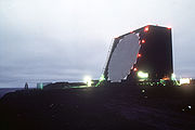
. This radar system was built in 1976 and brought on-line in 1977 for the primary mission of intelligence gathering in support of verification of the SALT II arms limitation treaty. Its single face radar with a 29 m (95.1 ft) diameter phased array radar antenna
Antenna (radio)
An antenna is an electrical device which converts electric currents into radio waves, and vice versa. It is usually used with a radio transmitter or radio receiver...
52.7373°N 174.0914°E faces the Kamchatka Peninsula
Kamchatka Peninsula
The Kamchatka Peninsula is a peninsula in the Russian Far East, with an area of . It lies between the Pacific Ocean to the east and the Sea of Okhotsk to the west...
and Kura Test Range
Kura Test Range
Kura Test Range is an intercontinental ballistic missile impact area used by Russia, located in northern Kamchatka Krai. It is northeast of the settlement of Klyuchi. The center coordinates are...
. Cobra Dane operates in the 1215-1400 MHz band.
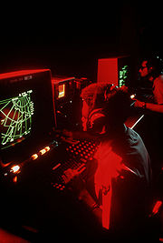
It initially employed a Control Data Corporation
Control Data Corporation
Control Data Corporation was a supercomputer firm. For most of the 1960s, it built the fastest computers in the world by far, only losing that crown in the 1970s after Seymour Cray left the company to found Cray Research, Inc....
Cyber 74 mainframe computer for data processing.
Data from the radar is sent to the North American Aerospace Defense Command
North American Aerospace Defense Command
North American Aerospace Defense Command is a joint organization of Canada and the United States that provides aerospace warning, air sovereignty, and defense for the two countries. Headquarters NORAD is located at Peterson AFB, Colorado Springs, Colorado...
(NORAD) at Cheyenne Mountain Operations Center
Cheyenne Mountain
Cheyenne Mountain is a mountain located just outside the southwest side of Colorado Springs, Colorado, U.S., and is home to the Cheyenne Mountain Air Force Station and its Cheyenne Mountain Directorate, formerly known as the Cheyenne Mountain Operations Center .Throughout the Cold War and...
. It is also listed as a partner of the NASA Orbital Debris Program Office
NASA Orbital Debris Program Office
The NASA Orbital Debris Program Office is located at the Johnson Space Center and is the lead NASA center for orbital debris research. It is recognized world-wide for its leadership in addressing orbital debris issues...
and works with the Missile Defense Agency
Missile Defense Agency
The Missile Defense Agency is the section of the United States government's Department of Defense responsible for developing a layered defense against ballistic missiles. The agency has its origins in the Strategic Defense Initiative, which was established in 1983 and was headed by Lt...
.
See also
- Eareckson Air Station, Shemya island, AlaskaAlaskaAlaska is the largest state in the United States by area. It is situated in the northwest extremity of the North American continent, with Canada to the east, the Arctic Ocean to the north, and the Pacific Ocean to the west and south, with Russia further west across the Bering Strait...
- Specific US radar and locations
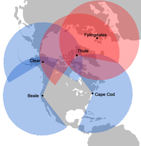
- Thule Air BaseThule Air BaseThule Air Base or Thule Air Base/Pituffik Airport , is the United States Air Force's northernmost base, located north of the Arctic Circle and from the North Pole on the northwest side of the island of Greenland. It is approximately east of the North Magnetic Pole.-Overview:Thule Air Base is the...
, GreenlandGreenlandGreenland is an autonomous country within the Kingdom of Denmark, located between the Arctic and Atlantic Oceans, east of the Canadian Arctic Archipelago. Though physiographically a part of the continent of North America, Greenland has been politically and culturally associated with Europe for... - Clear Air Force StationClear Air Force StationClear Air Force Station is a United States Air Force Station located 5 miles south of Anderson, Alaska, USA, northeast of Mount McKinley, and southwest of Fairbanks. Its primary mission is to detect incoming ICBMs and submarine-launched ballistic missiles.-Overview:Clear AFS is operated by the...
, AlaskaAlaskaAlaska is the largest state in the United States by area. It is situated in the northwest extremity of the North American continent, with Canada to the east, the Arctic Ocean to the north, and the Pacific Ocean to the west and south, with Russia further west across the Bering Strait... - RAF FylingdalesRAF FylingdalesRAF Fylingdales is a Royal Air Force station on Snod Hill in the North York Moors, England. Its motto is "Vigilamus" . It is a radar base and part of the United States-controlled Ballistic Missile Early Warning System...
, United KingdomUnited KingdomThe United Kingdom of Great Britain and Northern IrelandIn the United Kingdom and Dependencies, other languages have been officially recognised as legitimate autochthonous languages under the European Charter for Regional or Minority Languages... - Cape Cod Air Force StationCape Cod Air Force StationCape Cod Air Force Station is a US Air Force station located in the northwest corner of the Massachusetts Military Reservation, USA, on Flatrock Hill...
, MassachusettsMassachusettsThe Commonwealth of Massachusetts is a state in the New England region of the northeastern United States of America. It is bordered by Rhode Island and Connecticut to the south, New York to the west, and Vermont and New Hampshire to the north; at its east lies the Atlantic Ocean. As of the 2010... - Beale Air Force BaseBeale Air Force BaseBeale Air Force Base is a United States Air Force base located approximately east of Marysville, California. Originally known as Camp Beale....
, CaliforniaCaliforniaCalifornia is a state located on the West Coast of the United States. It is by far the most populous U.S. state, and the third-largest by land area... - Cavalier Air Force StationCavalier Air Force StationCavalier Air Force Station is a United States Air Force installation in Pembina County, North Dakota, home to the 10th Space Warning Squadron of the 21st Space Wing based at Peterson Air Force Base in Colorado.-Mission:...
, North DakotaNorth DakotaNorth Dakota is a state located in the Midwestern region of the United States of America, along the Canadian border. The state is bordered by Canada to the north, Minnesota to the east, South Dakota to the south and Montana to the west. North Dakota is the 19th-largest state by area in the U.S....
- Thule Air Base