

Outflow boundary
Encyclopedia

Storm-scale
Storm-scale is a scale of sizes of weather systems on the order of individual thunderstorms.-See also:* Synoptic scale meteorology* Mesoscale meteorology* Microscale meteorology* Misoscale meteorology...
or mesoscale
Mesoscale meteorology
Mesoscale meteorology is the study of weather systems smaller than synoptic scale systems but larger than microscale and storm-scale cumulus systems. Horizontal dimensions generally range from around 5 kilometers to several hundred kilometers...
boundary separating thunderstorm
Thunderstorm
A thunderstorm, also known as an electrical storm, a lightning storm, thundershower or simply a storm is a form of weather characterized by the presence of lightning and its acoustic effect on the Earth's atmosphere known as thunder. The meteorologically assigned cloud type associated with the...
-cooled air (outflow
Outflow (meteorology)
Outflow, in meteorology, is air that flows outwards from a storm system. It is associated with ridging, or anticyclonic flow. In the low levels of the troposphere, outflow radiates from thunderstorms in the form of a wedge of rain-cooled air, which is visible as a thin rope-like cloud on weather...
) from the surrounding air; similar in effect to a cold front
Cold front
A cold front is defined as the leading edge of a cooler mass of air, replacing a warmer mass of air.-Development of cold front:The cooler and denser air wedges under the less-dense warmer air, lifting it...
, with passage marked by a wind
Wind
Wind is the flow of gases on a large scale. On Earth, wind consists of the bulk movement of air. In outer space, solar wind is the movement of gases or charged particles from the sun through space, while planetary wind is the outgassing of light chemical elements from a planet's atmosphere into space...
shift and usually a drop in temperature
Temperature
Temperature is a physical property of matter that quantitatively expresses the common notions of hot and cold. Objects of low temperature are cold, while various degrees of higher temperatures are referred to as warm or hot...
and a related pressure jump. Outflow boundaries can persist for 24 hours or more after the thunderstorms that generated them dissipate, and can travel hundreds of kilometres (miles) from their area of origin. New thunderstorms often develop along outflow boundaries, especially near the point of intersection with another boundary (cold front
Cold front
A cold front is defined as the leading edge of a cooler mass of air, replacing a warmer mass of air.-Development of cold front:The cooler and denser air wedges under the less-dense warmer air, lifting it...
, dry line
Dry line
A dry line separates moist air from the Gulf of Mexico and dry desert air from the south-western states . The dry line is an important factor in severe weather frequency in the Great Plains of North America...
, another outflow boundary, etc.). Outflow boundaries can be seen either as fine lines on weather radar
Weather radar
Weather radar, also called weather surveillance radar and Doppler weather radar, is a type of radar used to locate precipitation, calculate its motion, estimate its type . Modern weather radars are mostly pulse-Doppler radars, capable of detecting the motion of rain droplets in addition to the...
imagery or else as arcs of low clouds on weather satellite
Weather satellite
The weather satellite is a type of satellite that is primarily used to monitor the weather and climate of the Earth. Satellites can be either polar orbiting, seeing the same swath of the Earth every 12 hours, or geostationary, hovering over the same spot on Earth by orbiting over the equator while...
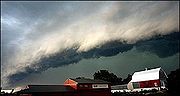
imagery. From the ground, outflow boundaries can be co-located with the appearance of roll clouds and shelf clouds.
Outflow boundaries create low-level wind shear
Wind shear
Wind shear, sometimes referred to as windshear or wind gradient, is a difference in wind speed and direction over a relatively short distance in the atmosphere...
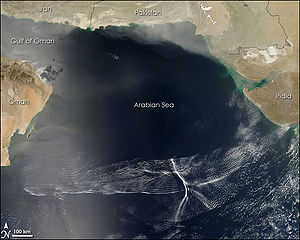
which can be hazardous during aircraft takeoffs and landings. If a thunderstorm runs into an outflow boundary, the low-level wind shear from the boundary can cause thunderstorms to exhibit rotation at the base of the storm, at times causing tornadic activity. Strong versions of these features known as downbursts can be generated in environments of vertical wind shear and mid-level dry air. Microbursts have a diameter of influence less than 4 kilometres (2.5 mi), while macrobursts occur over a diameter greater than 4 kilometres (2.5 mi). Wet microbursts occur in atmospheres where the low levels are saturated, while dry microbursts occur in drier atmospheres from high-based thunderstorms. When an outflow boundary moves into a more stable low level environment, such as into a region of cooler air or over regions of cooler water temperatures out at sea, it can lead to the development of an undular bore
Undular bore
In meteorology, an undular bore is a wave disturbance in the Earth's atmosphere and can be seen through unique cloud formations. They normally occur within an area of the atmosphere which is stable in the low levels after an outflow boundary or a cold front moves through.In hydraulics, an undular...
.
Definition

Wind
Wind is the flow of gases on a large scale. On Earth, wind consists of the bulk movement of air. In outer space, solar wind is the movement of gases or charged particles from the sun through space, while planetary wind is the outgassing of light chemical elements from a planet's atmosphere into space...
s from thunderstorm downdrafts; sometimes associated with a shelf cloud or roll cloud. A pressure jump is associated with its passage. Outflow boundaries can persist for over 24 hours and travel hundreds of kilometers (miles) from their area of origin. A wrapping gust front is a front that wraps around the mesocyclone
Mesocyclone
A mesocyclone is a vortex of air, approximately 2 to 10 miles in diameter , within a convective storm....
, cutting off the inflow of warm moist air and resulting in occlusion. This is sometimes the case during the event of a collapsing storm, in which the wind literally "rips it apart".
Origin
A microburst
Microburst
A microburst is a very localized column of sinking air, producing damaging divergent and straight-line winds at the surface that are similar to, but distinguishable from, tornadoes, which generally have convergent damage. There are two types of microbursts: wet microbursts and dry microbursts...
is a very localized column of sinking air known as a downburst, producing damaging divergent and straight-line winds at the surface that are similar to but distinguishable from tornado
Tornado
A tornado is a violent, dangerous, rotating column of air that is in contact with both the surface of the earth and a cumulonimbus cloud or, in rare cases, the base of a cumulus cloud. They are often referred to as a twister or a cyclone, although the word cyclone is used in meteorology in a wider...
es which generally have convergent damage. The term was defined as affecting an area 4 kilometres (2.5 mi) in diameter or less, distinguishing them as a type of downburst and apart from common wind shear which can encompass greater areas. They are normally associated with individual thunderstorms. Microburst soundings show the presence of mid-level dry air, which enhances evaporative cooling.
Organized areas of thunderstorm activity reinforce pre-existing frontal zones, and can outrun cold fronts. This outrunning occurs within the westerlies
Westerlies
The Westerlies, anti-trades, or Prevailing Westerlies, are the prevailing winds in the middle latitudes between 30 and 60 degrees latitude, blowing from the high pressure area in the horse latitudes towards the poles. These prevailing winds blow from the west to the east, and steer extratropical...
in a pattern where the upper level jet splits into two streams. The resultant mesoscale convective system
Mesoscale Convective System
A mesoscale convective system is a complex of thunderstorms that becomes organized on a scale larger than the individual thunderstorms but smaller than extratropical cyclones, and normally persists for several hours or more...
(MCS) forms at the point of the upper level split in the wind pattern in the area of best low level inflow. The convection then moves east and toward the equator
Equator
An equator is the intersection of a sphere's surface with the plane perpendicular to the sphere's axis of rotation and containing the sphere's center of mass....
into the warm sector, parallel to low-level thickness lines. When the convection is strong and linear or curved, the MCS is called a squall line
Squall line
A squall line is a line of severe thunderstorms that can form along or ahead of a cold front. In the early 20th century, the term was used as a synonym for cold front. It contains heavy precipitation, hail, frequent lightning, strong straight-line winds, and possibly tornadoes and waterspouts....
, with the feature placed at the leading edge of the significant wind shift and pressure rise which is normally just ahead of its radar signature. This feature is commonly depicted in the warm season across the United States
United States
The United States of America is a federal constitutional republic comprising fifty states and a federal district...
on surface analyses, as they lie within sharp surface troughs.
A macroburst, normally associated with squall lines, is a strong downburst larger than 4 kilometres (2.5 mi). A wet microburst consists of precipitation and an atmosphere saturated in the low-levels. A dry microburst emanates from high-based thunderstorms with virga
Virga
In meteorology, virga is an observable streak or shaft of precipitation that falls from a cloud but evaporates before reaching the ground. At high altitudes the precipitation falls mainly as ice crystals before melting and finally evaporating; this is usually due to compressional heating, because...
falling from their base. All types are formed by precipitation-cooled air rushing to the surface. Downbursts can occur over large areas. In the extreme case, a derecho
Derecho
A derecho is a widespread and long-lived, violent convectively induced straight-line windstorm that is associated with a fast-moving band of severe thunderstorms in the form of a squall line usually taking the form of a bow echo...
can cover a huge area more than 200 miles (321.9 km) wide and over 1000 miles (1,609.3 km) long, lasting up to 12 hours or more, and is associated with some of the most intense straight-line winds, but the generative process is somewhat different from that of most downbursts.
Appearance
Weather satellite
The weather satellite is a type of satellite that is primarily used to monitor the weather and climate of the Earth. Satellites can be either polar orbiting, seeing the same swath of the Earth every 12 hours, or geostationary, hovering over the same spot on Earth by orbiting over the equator while...
imagery, an arc cloud is visible as an arc of low clouds spreading out from a thunderstorm. If the skies are cloudy behind the arc, or if the arc is moving quickly indicate that high wind gusts are likely behind the gust front. Sometimes a gust front can be seen on weather radar
Weather radar
Weather radar, also called weather surveillance radar and Doppler weather radar, is a type of radar used to locate precipitation, calculate its motion, estimate its type . Modern weather radars are mostly pulse-Doppler radars, capable of detecting the motion of rain droplets in addition to the...
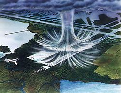
, showing as a thin arc or line of weak radar echos pushing out from a collapsing storm. The thin line of weak radar echoes is known as a fine line. Occasionally, winds caused by the gust front are so high in velocity that they also show up on radar. This cool outdraft can then energize other storms which it hits by assisting in updrafts. Gust fronts colliding from two storms can even create new storms. Usually, however, no rain accompanies the shifting winds. An expansion of the rain shaft near ground level, in the general shape of a human foot, is a telltale sign of a downburst. Gustnadoes, short-lived vertical circulations near ground level, can be spawned by outflow boundaries.
Effects
Gust fronts create low-level wind shear
Wind shear
Wind shear, sometimes referred to as windshear or wind gradient, is a difference in wind speed and direction over a relatively short distance in the atmosphere...
which can be hazardous to planes when they takeoff or land. Flying insect
Insect
Insects are a class of living creatures within the arthropods that have a chitinous exoskeleton, a three-part body , three pairs of jointed legs, compound eyes, and two antennae...
s, a subset of arthropods, are swept along by the prevailing winds
Prevailing winds
Prevailing winds are winds that blow predominantly from a single general direction over a particular point on Earth's surface. The dominant winds are the trends in direction of wind with the highest speed over a particular point on the Earth's surface. A region's prevailing and dominant winds...
. As such, fine line patterns within weather radar
Weather radar
Weather radar, also called weather surveillance radar and Doppler weather radar, is a type of radar used to locate precipitation, calculate its motion, estimate its type . Modern weather radars are mostly pulse-Doppler radars, capable of detecting the motion of rain droplets in addition to the...
imagery, associated with converging winds, are dominated by insect returns. At the surface, clouds of dust can be raised by outflow boundaries. If squall lines form over arid regions, a duststorm known as a haboob
Haboob
A haboob is a type of intense duststorm carried on an atmospheric gravity current. Haboobs are regularly observed in arid regions throughout the world. They have been observed in the Sahara desert , as well as across the Arabian Peninsula, throughout Kuwait, and in the most arid regions of Iraq...
can result from the high winds picking up dust in their wake from the desert floor. If outflow boundaries move into areas of the atmosphere which are stable in the low levels, such as over colder pockets of ocean or through the cold sector of extratropical cyclone
Extratropical cyclone
Extratropical cyclones, sometimes called mid-latitude cyclones or wave cyclones, are a group of cyclones defined as synoptic scale low pressure weather systems that occur in the middle latitudes of the Earth having neither tropical nor polar characteristics, and are connected with fronts and...
s, they can create a phenomenon known as an undular bore, which shows up on satellite and radar imagery as a series of transverse wave
Transverse wave
A transverse wave is a moving wave that consists of oscillations occurring perpendicular to the direction of energy transfer...
s in the cloud field oriented perpendicular to the low-level winds.
See also
- DensityDensityThe mass density or density of a material is defined as its mass per unit volume. The symbol most often used for density is ρ . In some cases , density is also defined as its weight per unit volume; although, this quantity is more properly called specific weight...
- DerechoDerechoA derecho is a widespread and long-lived, violent convectively induced straight-line windstorm that is associated with a fast-moving band of severe thunderstorms in the form of a squall line usually taking the form of a bow echo...
- GustnadoGustnadoA gustnado is a specific type of short-lived, low-level rotating cloud that can form in a severe thunderstorm. The name is a portmanteau of "gust front tornado", as gustnadoes form due to non-tornadic cyclonic features in the downdraft from the gust front of a strong thunderstorm, especially one...
- HaboobHaboobA haboob is a type of intense duststorm carried on an atmospheric gravity current. Haboobs are regularly observed in arid regions throughout the world. They have been observed in the Sahara desert , as well as across the Arabian Peninsula, throughout Kuwait, and in the most arid regions of Iraq...
- Heat burstHeat burstIn meteorology, a heat burst is a rare atmospheric phenomenon characterised by gusty winds and a rapid increase in temperature and decrease in dew point...
- Inflow (meteorology)Inflow (meteorology)Inflow is the flow of a fluid into a large collection of that fluid. Within meteorology, inflow normally refers to the influx of warmth and moisture from air within the Earth's atmosphere into storm systems. Extratropical cyclones are fed by inflow focused along their cold front and warm fronts...
- Lake effect
- Mathematical singularityMathematical singularityIn mathematics, a singularity is in general a point at which a given mathematical object is not defined, or a point of an exceptional set where it fails to be well-behaved in some particular way, such as differentiability...
- Sea breezeSea breezeA sea-breeze is a wind from the sea that develops over land near coasts. It is formed by increasing temperature differences between the land and water; these create a pressure minimum over the land due to its relative warmth, and forces higher pressure, cooler air from the sea to move inland...
- Tropical cyclogenesisTropical cyclogenesisTropical cyclogenesis is the term that describes the development and strengthening of a tropical cyclone in the atmosphere. The mechanisms through which tropical cyclogenesis occurs are distinctly different from those through which mid-latitude cyclogenesis occurs...
- Wake lowWake lowA wake low, or wake depression, is a mesoscale low-pressure area which trails the mesoscale high following a squall line. Due to the subsiding warm air associated with the systems formation, clearing skies are associated with the wake low...
- Weather frontWeather frontA weather front is a boundary separating two masses of air of different densities, and is the principal cause of meteorological phenomena. In surface weather analyses, fronts are depicted using various colored lines and symbols, depending on the type of front...
External links
- Outflow boundary over south Florida MPEG, 854KB