
Offshore oil and gas in the United States
Encyclopedia
Offshore oil and gas in the United States provides a large portion of the nation’s oil and gas supply. Large oil and gas reservoirs are found in the sea nearby Louisiana
, Texas
, California
, and Alaska
. Environmental concerns have prevented or restricted offshore drilling in some areas, and the issue has been hotly debated at the local and national levels.
 From 1954 to 2007, federal offshore tracts produced 16800000000 barrels (2,670,986,556 m³) of oil and 173000000000000 cubic feet (4,898.8 km³) of natural gas.
In 2007, federal offshore tracts produced 27% of the oil and 14% of the natural gas in the United States. Three of the top ten oil fields in the United States in terms of the proven remaining reserves were offshore in the Gulf of Mexico in 2007 (Mars-Ursa, Thunder Horse, and Atlantis). The oil production in the offshore area owned by the federal government reached 492000000 barrels (78,221,749.1 m³) in 2007, down from the record of 602000000 barrels (95,710,351,590 l) produced in 2002. 2.86 TCF of offshore gas produced in 2007 was down from the high of 5.25 TCF produced in 1996.
). The US Supreme Court ruled in 1947 that the federal government owned all the seabed off the California coast; the court applied the same doctrine against Louisiana and Texas in 1950. The court ruling invalidated existing state leases over producing offshore oil fields in the three states. However, the US Congress passed the Submerged Land Act in 1953, which recognized state ownership of the seabed within 3 nautical miles (6 km) of the shore. That same year Congress also passed the Outer Continental Shelf
Act, which gave the federal government jurisdiction over minerals on and under the seabed farther offshore from state waters.
The first federal offshore lease sale was held in 1954, to offer oil production rights under federal seabed in offshore Louisiana.
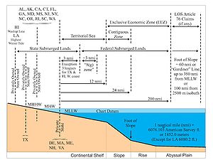 Each coastal state owns the territory extending 3 nautical miles (6 km) from the shore at mean low tide, and has jurisdiction to decide whether or not, and under what terms, to lease the territory for oil and gas. Exceptions include Texas
and the west coast of Florida
, which for historical reasons own the seabed out to 9 nautical miles (16.7 km) from the shore. Louisiana
is included in the 3 nautical mile rule, but because it had active offshore leases defined before 1950 (and before most other states), its territory is measured using the Admiralty Nautical Mile, while other states use the International Nautical Mile, adopted by the United States in 1954.
The exact definition of the shoreline, dividing state waters offshore and potential private land onshore, depends on state law. Shifting shorelines in the vicinity of oil fields have been a thorny issue. In the Goose Creek field
along the coast in Harris County, Texas
, so much oil was produced that the ground elevation sank ten or more feet, putting some privately owned oil-producing lands below sea level. The state of Texas then declared that the newly submerged land, along with its oil revenue, was state property.
; the proclamation was codified by Outer Continental Shelf Lands Act of 1953. The Geneva Convention on the continental shelf in 1958 recognized the right of each nation to the mineral resources on its adjacent continental shelf, out to a water depth of 200 m. In 1983, President Ronald Reagan
issued a proclamation extending the US Exclusive Economic Zone to 200 nautical miles (370.4 km) from the shore.
By virtue of the Law of the Sea
, which the US has signed but not ratified, each nation controls an Exclusive Economic Zone
(EEZ) that extends 200 nautical miles (370.4 km) from its shore. The EEZ confers exclusive rights to a nation to explore and produce minerals, including oil and gas. In areas within 200 nautical miles of two or more nations, the territorial line is drawn equidistant from the shores of the two nations. The US and Canada referred a dispute over the EEZ boundary in the Atlantic Ocean to the International Court of Justice
, which decided the matter (see Georges Bank
). Article 76 of the Law of the Sea provides that nations may under certain circumstances extend their EEZs beyond the 200 nautical mile limit, to up to 350 nautical miles (648.2 km) from shore.
The 200 nautical mile EEZ left a small area in the western Gulf of Mexico
enclosed by the EEZs of the United States and Mexico
, but outside the EEZ of either nation (the "doughnut hole"). The US and Mexico concluded a treaty to divide the area between them. A second, and as yet unresolved "doughnut hole" exists in the eastern Gulf of Mexico, bordered by the EEZs of the US, Mexico, and Cuba
.
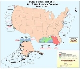
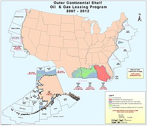
Leasing and drilling on federal offshore seabed is controlled by the US Bureau of Ocean Energy Management, Regulation and Enforcement (BOEMRE), previously named the US Minerals Management Service
(MMS). The BOEMRE issues leases through competitive bidding by sealed bids. The oil and gas company offering the highest up-front payment to the government (called a bonus) wins the lease. The government also receives a fixed annual rental based on the area for non-producing leases, and a percentage of the market value of any oil or gas produced and sold (royalty). The leases expire after a set number of years, or continue however long afterward that oil and gas are produced from the lease. Individual tracts are generally 9 square miles (23.3 km²). Current leases being offered in the Gulf of Mexico have 5-year terms for tracts in water depths of less than 400 m, and 8 years for tracts in water greater than 400 m. Royalty rates are 18.75% regardless of water depth. From 1954 through 2004, the federal government received $64 billion in bonuses, $3 billion in rentals, $89 billion in royalties, and $3 billion in taken-in-kind oil deliveries in lieu of royalties.
and the Arctic Ocean
. Endicott Island
is an artificial island built to produce oil from beneath the Beaufort Sea
.
Offshore drilling began in California in 1896, when operators in the Summerland Oil Field
in Santa Barbara County
followed the field into the ocean by drilling from piers built out over the ocean.
Leasing California state seabed is controlled by the State Lands Commission, which halted further leasing of state offshore tracts after the Santa Barbara oil spill in 1969. In 1994 the California legislature codified the ban on new leases by passing the California Coastal Sanctuary Act, which prohibited new leasing of state offshore tracts.
State offshore seabed in California produced 37400 barrels (5,946,124.8 l) of oil per day, and federal offshore tracts produced 66400 barrels (10,556,756.4 l) of oil per day in November 2008. State and federal offshore tracts together made up 16% of the state's oil production. Notable offshore fields include the Ellwood Oil Field
, which is partially onshore and partially offshore, and the Dos Cuadras Field
, source of the 1969 spill, which is entirely within the federal zone.
The western and central Gulf of Mexico
, which includes offshore Texas, Louisiana, Mississippi, and Alabama, is one of the major petroleum-producing areas of the United States. In 2007, federal leases in the western and central Gulf of Mexico produced 25% of the nation's oil and 14% of the nation's natural gas. In 2008, federal leases in the Gulf of Mexico produced 418000000 barrels (66,456,689,310 l) of oil, down from 568000000 barrels (90,304,783,560 l) in 2002; however, due to new deep-water discoveries, the MMS projects that oil production from the Gulf of Mexico will increase to 686000000 barrels (109,065,284,370 l) per year by 2013.
Major fields include Atlantis Oil Field
, and the Tiber oilfield
(discovered 2009) and others in the Keathley Canyon
protraction area. Notable oil platforms include Baldpate
, Bullwinkle
, Mad Dog
, Magnolia, Mars, Petronius, and Thunder Horse. Notable individual wells include Jack 2
and Knotty Head
.
The eastern Gulf of Mexico, which includes offshore Gulf Coast Florida, has never been a petroleum-producing area due to federal and state restrictions on exploration. Offshore platforms currently exist as far east as to near the Florida-Alabama border.
In the late 1970s and early 1980s oil companies drilled 51 exploratory wells on federal leases on the outer continental shelf of the Atlantic coast. All the leases have now reverted to the government. A 1996 study by the MMS estimated undiscovered conventionally recoverable resources in Atlantic federal waters to be 7200000000 barrels (1.1 km³) of oil and 27500000000000 cubic feet (778.7 km³) gas.
and Washington. Oil companies drilled six tests offshore Washington (three in state waters and three in federal waters) and seven tests in federal waters offshore Oregon. The OCS P-0130 well drilled offshore Oregon by Union Oil in 1966 was described as having "potential for commercial gas production", but none of the wells were completed as producers, and the federal leases expired in 1969.
Farther north, in Canadian waters, Shell Canada
drilled 14 wells offshore from Vancouver Island
from 1967-1969. None were successful. Canada has had a federal moratorium on offshore drilling on its west coast since 1972.
are owned by the adjacent states. The only state that has allowed oil and gas drilling beneath the Great Lakes in recent years has been Michigan
, and that only by directional drilling
from onshore surface locations. All oil and gas drilling, either on or directionally beneath the Great Lakes, has been banned by federal law since 2002.
The Canadian side of Lake Erie
has 480 producing gas wells in the lake. Gas production in Canadian Lake Erie waters dates back to 1913; more than 2000 wells have been drilled to the Clinton Sand, up to a few miles from the US side of the lake; the same formation produces gas from many onshore wells on the US side, but there are no wells in the US portion of the lake. The province of Ontario
, where the offshore wells are located, allows gas wells, but not oil wells, in offshore Lake Erie. Ontario allows oil production from below the lake only from wells drilled directionally from onshore surface locations; a number of such directional wells are producing oil from beneath Lake Erie in the Goldsmith/Lakeshore Field.
A gas well to the Medina Group was drilled in 1958 in Pennsylvania state waters in Lake Erie.
The only state that has current oil and gas production from beneath the Great Lakes is Michigan. Michigan has 13 oil and gas wells that produce from below Lake Michigan
, all drilled directionally from surface locations on shore. Directional drilling beneath the Great Lakes is now banned.
The US Geological Survey has estimated that 430000000 barrels (68,364,536.9 m³) of recoverable petroleum liquids and 5200000000000 cubic feet (147.2 km³) of recoverable natural gas underlie the US portion of the Great Lakes. Petroleum potential was given to all of the lakes except Lake Superior
. The majority of the natural gas (3.0 TCF) is thought to underlie Lake Erie.
 Congress passed the Marine Protection, Research and Sanctuaries Act in 1972, which provided for the establishment of National Marine Sanctuaries
, in which certain activities, including oil and gas drilling, are prohibited. To date, 13 sanctuaries with a combined area of 150000 square miles (388,498.2 km²) have been so designated.
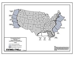
In 1982, the US Congress directed that no federal funds be used to lease federal tracts off the coasts of Washington, Oregon, or central and northern California. Over the years Congress added other areas until the prohibited area included all the east and west coasts, and the eastern Gulf of Mexico. Congress repeated the effective ban on offshore drilling in these areas every year until September 2008, when an appropriations bill passed the House and Senate without the ban.
In 1990, Congress passed the North Carolina Outer Banks Protection Act, prohibiting leasing and drilling on federal seabed offshore from North Carolina
.
In 1990, President George H. W. Bush
issued an executive moratorium restricting federal offshore leasing to Texas, Louisiana, Mississippi, Alabama, and parts of Alaska. The moratorium banned federal leasing through the year 2000 off the East Coast, West Coast, the eastern Gulf of Mexico (offshore Florida Gulf Coast), and the Northern Aleutian Basin of Alaska. In 1998, President Bill Clinton
extended the moratorium through 2012. In July 2008, President George W. Bush
rescinded the executive order.
In 2002, Congress imposed a moratorium on drilling on or directionally beneath the Great Lakes. The ban was made permanent by the Energy Policy Act of 2005
.
Part of the central and most of the eastern Gulf of Mexico was declared off-limits to oil and gas leasing until 2022 by the Gulf of Mexico Energy Security Act of 2006.
, salt
, sand and gravel, phosphate rock, manganese nodules, and heavy-mineral placer
deposits. To date, none of these has been produced for commercial purposes except sulfur and salt, although the MMS has allowed sand dredging in federal waters to restore damaged beaches in Maryland, Virginia, South Carolina, and Florida.
From 1960 to 2000, sulfur was mined by the Frasch process
from the caprock of a salt dome
at the Main Pass 299 mine, offshore Louisiana. A total of 34 million short tons of sulfur were recovered before the mine was closed; salt was also recovered.
Louisiana
Louisiana is a state located in the southern region of the United States of America. Its capital is Baton Rouge and largest city is New Orleans. Louisiana is the only state in the U.S. with political subdivisions termed parishes, which are local governments equivalent to counties...
, Texas
Texas
Texas is the second largest U.S. state by both area and population, and the largest state by area in the contiguous United States.The name, based on the Caddo word "Tejas" meaning "friends" or "allies", was applied by the Spanish to the Caddo themselves and to the region of their settlement in...
, California
California
California is a state located on the West Coast of the United States. It is by far the most populous U.S. state, and the third-largest by land area...
, and Alaska
Alaska
Alaska is the largest state in the United States by area. It is situated in the northwest extremity of the North American continent, with Canada to the east, the Arctic Ocean to the north, and the Pacific Ocean to the west and south, with Russia further west across the Bering Strait...
. Environmental concerns have prevented or restricted offshore drilling in some areas, and the issue has been hotly debated at the local and national levels.
Production
In 2007, federal offshore tracts produced 27% of the oil and 14% of the natural gas in the United States. Three of the top ten oil fields in the United States in terms of the proven remaining reserves were offshore in the Gulf of Mexico in 2007 (Mars-Ursa, Thunder Horse, and Atlantis). The oil production in the offshore area owned by the federal government reached 492000000 barrels (78,221,749.1 m³) in 2007, down from the record of 602000000 barrels (95,710,351,590 l) produced in 2002. 2.86 TCF of offshore gas produced in 2007 was down from the high of 5.25 TCF produced in 1996.
Ownership of offshore oil and gas
The issue of state versus federal ownership has a long and contentious history (see TidelandsTidelands
Tidelands are the territory between the high and low water tide line of sea coasts, and lands lying under the sea beyond the low-water limit of the tide, considered within the territorial waters of a nation. The United States Constitution does not specify whether ownership of these lands rests with...
). The US Supreme Court ruled in 1947 that the federal government owned all the seabed off the California coast; the court applied the same doctrine against Louisiana and Texas in 1950. The court ruling invalidated existing state leases over producing offshore oil fields in the three states. However, the US Congress passed the Submerged Land Act in 1953, which recognized state ownership of the seabed within 3 nautical miles (6 km) of the shore. That same year Congress also passed the Outer Continental Shelf
Outer Continental Shelf
The Outer Continental Shelf is a peculiarity of the political geography of the United States and is the part of the internationally recognized continental shelf of the United States which does not fall under the jurisdictions of the individual U.S...
Act, which gave the federal government jurisdiction over minerals on and under the seabed farther offshore from state waters.
The first federal offshore lease sale was held in 1954, to offer oil production rights under federal seabed in offshore Louisiana.
State ownership
Texas
Texas is the second largest U.S. state by both area and population, and the largest state by area in the contiguous United States.The name, based on the Caddo word "Tejas" meaning "friends" or "allies", was applied by the Spanish to the Caddo themselves and to the region of their settlement in...
and the west coast of Florida
Florida
Florida is a state in the southeastern United States, located on the nation's Atlantic and Gulf coasts. It is bordered to the west by the Gulf of Mexico, to the north by Alabama and Georgia and to the east by the Atlantic Ocean. With a population of 18,801,310 as measured by the 2010 census, it...
, which for historical reasons own the seabed out to 9 nautical miles (16.7 km) from the shore. Louisiana
Louisiana
Louisiana is a state located in the southern region of the United States of America. Its capital is Baton Rouge and largest city is New Orleans. Louisiana is the only state in the U.S. with political subdivisions termed parishes, which are local governments equivalent to counties...
is included in the 3 nautical mile rule, but because it had active offshore leases defined before 1950 (and before most other states), its territory is measured using the Admiralty Nautical Mile, while other states use the International Nautical Mile, adopted by the United States in 1954.
The exact definition of the shoreline, dividing state waters offshore and potential private land onshore, depends on state law. Shifting shorelines in the vicinity of oil fields have been a thorny issue. In the Goose Creek field
Goose Creek Oil Field
The Goose Creek Oil Field is a large oil field in Baytown, Texas, on Galveston Bay. Discovered in 1903, and reaching maximum production in 1918 after a series of spectacular gushers, it was one of the fields which contributed to the Texas Oil Boom of the early 20th century...
along the coast in Harris County, Texas
Harris County, Texas
As of the 2010 Census, the population of the county was 4,092,459, White Americans made up 56.6% of Harris County's population; non-Hispanic whites represented 33.0% of the population. Black Americans made up 18.9% of the population. Native Americans made up 0.7% of Harris County's population...
, so much oil was produced that the ground elevation sank ten or more feet, putting some privately owned oil-producing lands below sea level. The state of Texas then declared that the newly submerged land, along with its oil revenue, was state property.
Federal ownership
Traditionally, nations owned the territory extending 12 nautical miles (22.2 km) from shore. In 1945, President Harry Truman issued a proclamation extending US jurisdiction over mineral resources to the edge of the continental shelfContinental shelf
The continental shelf is the extended perimeter of each continent and associated coastal plain. Much of the shelf was exposed during glacial periods, but is now submerged under relatively shallow seas and gulfs, and was similarly submerged during other interglacial periods. The continental margin,...
; the proclamation was codified by Outer Continental Shelf Lands Act of 1953. The Geneva Convention on the continental shelf in 1958 recognized the right of each nation to the mineral resources on its adjacent continental shelf, out to a water depth of 200 m. In 1983, President Ronald Reagan
Ronald Reagan
Ronald Wilson Reagan was the 40th President of the United States , the 33rd Governor of California and, prior to that, a radio, film and television actor....
issued a proclamation extending the US Exclusive Economic Zone to 200 nautical miles (370.4 km) from the shore.
By virtue of the Law of the Sea
Law of the sea
Law of the sea may refer to:* United Nations Convention on the Law of the Sea* Admiralty law* The Custom of the Sea...
, which the US has signed but not ratified, each nation controls an Exclusive Economic Zone
Exclusive Economic Zone
Under the law of the sea, an exclusive economic zone is a seazone over which a state has special rights over the exploration and use of marine resources, including production of energy from water and wind. It stretches from the seaward edge of the state's territorial sea out to 200 nautical...
(EEZ) that extends 200 nautical miles (370.4 km) from its shore. The EEZ confers exclusive rights to a nation to explore and produce minerals, including oil and gas. In areas within 200 nautical miles of two or more nations, the territorial line is drawn equidistant from the shores of the two nations. The US and Canada referred a dispute over the EEZ boundary in the Atlantic Ocean to the International Court of Justice
International Court of Justice
The International Court of Justice is the primary judicial organ of the United Nations. It is based in the Peace Palace in The Hague, Netherlands...
, which decided the matter (see Georges Bank
Georges Bank
Georges Bank is a large elevated area of the sea floor which separates the Gulf of Maine from the Atlantic Ocean and is situated between Cape Cod, Massachusetts and Cape Sable Island, Nova Scotia ....
). Article 76 of the Law of the Sea provides that nations may under certain circumstances extend their EEZs beyond the 200 nautical mile limit, to up to 350 nautical miles (648.2 km) from shore.
The 200 nautical mile EEZ left a small area in the western Gulf of Mexico
Gulf of Mexico
The Gulf of Mexico is a partially landlocked ocean basin largely surrounded by the North American continent and the island of Cuba. It is bounded on the northeast, north and northwest by the Gulf Coast of the United States, on the southwest and south by Mexico, and on the southeast by Cuba. In...
enclosed by the EEZs of the United States and Mexico
Mexico
The United Mexican States , commonly known as Mexico , is a federal constitutional republic in North America. It is bordered on the north by the United States; on the south and west by the Pacific Ocean; on the southeast by Guatemala, Belize, and the Caribbean Sea; and on the east by the Gulf of...
, but outside the EEZ of either nation (the "doughnut hole"). The US and Mexico concluded a treaty to divide the area between them. A second, and as yet unresolved "doughnut hole" exists in the eastern Gulf of Mexico, bordered by the EEZs of the US, Mexico, and Cuba
Cuba
The Republic of Cuba is an island nation in the Caribbean. The nation of Cuba consists of the main island of Cuba, the Isla de la Juventud, and several archipelagos. Havana is the largest city in Cuba and the country's capital. Santiago de Cuba is the second largest city...
.
Leasing and drilling on federal offshore seabed is controlled by the US Bureau of Ocean Energy Management, Regulation and Enforcement (BOEMRE), previously named the US Minerals Management Service
Minerals Management Service
The Bureau of Ocean Energy Management, Regulation and Enforcement , formerly known as the Minerals Management Service , was an agency of the United States Department of the Interior that managed the nation's natural gas, oil and other mineral resources on the outer continental shelf...
(MMS). The BOEMRE issues leases through competitive bidding by sealed bids. The oil and gas company offering the highest up-front payment to the government (called a bonus) wins the lease. The government also receives a fixed annual rental based on the area for non-producing leases, and a percentage of the market value of any oil or gas produced and sold (royalty). The leases expire after a set number of years, or continue however long afterward that oil and gas are produced from the lease. Individual tracts are generally 9 square miles (23.3 km²). Current leases being offered in the Gulf of Mexico have 5-year terms for tracts in water depths of less than 400 m, and 8 years for tracts in water greater than 400 m. Royalty rates are 18.75% regardless of water depth. From 1954 through 2004, the federal government received $64 billion in bonuses, $3 billion in rentals, $89 billion in royalties, and $3 billion in taken-in-kind oil deliveries in lieu of royalties.
International ownership
Some potential petroleum deposits underlie areas outside the EEZ. For example, the North Chuckchi Basin in the Arctic Ocean is partly inside and partly outside the US EEZ.Offshore drilling by area
Historically, offshore drilling began by extending known coastal oil- and gas-producing trends out into the ocean. For this reason, most US offshore drilling has taken place offshore Louisiana, Texas, California, and Alaska, areas with coastal onshore oil and gas fields.Alaska
The first federal lease sale offshore Alaska was held in 1976. Alaska produces oil and gas from offshore areas in the Cook InletCook Inlet
Cook Inlet stretches from the Gulf of Alaska to Anchorage in south-central Alaska. Cook Inlet branches into the Knik Arm and Turnagain Arm at its northern end, almost surrounding Anchorage....
and the Arctic Ocean
Arctic Ocean
The Arctic Ocean, located in the Northern Hemisphere and mostly in the Arctic north polar region, is the smallest and shallowest of the world's five major oceanic divisions...
. Endicott Island
Endicott Island
Endicott Island is a 45-acre artificial island located in the U.S. state of Alaska, 2.5 miles offshore and 15 miles from Prudhoe Bay of the Beaufort Sea...
is an artificial island built to produce oil from beneath the Beaufort Sea
Beaufort Sea
The Beaufort Sea is a marginal sea of the Arctic Ocean, located north of the Northwest Territories, the Yukon, and Alaska, west of Canada's Arctic islands. The sea is named after hydrographer Sir Francis Beaufort...
.
California
See Offshore oil and gas in CaliforniaOffshore oil and gas in California
Offshore oil and gas in California provides a significant portion of the state's petroleum production. Offshore oil and gas has been a contentious issue for decades, first over the question of state versus federal ownersip, but since 1969 mostly over questions of resource development versus...
Offshore drilling began in California in 1896, when operators in the Summerland Oil Field
Summerland Oil Field
The Summerland Oil Field is an inactive oil field in Santa Barbara County, California, about four miles east of the city of Santa Barbara, within and next to the unincorporated community of Summerland...
in Santa Barbara County
Santa Barbara County, California
Santa Barbara County is a county located in the southern portion of the U.S. state of California, on the Pacific coast. As of 2010 the county had a population of 423,895. The county seat is Santa Barbara and the largest city is Santa Maria.-History:...
followed the field into the ocean by drilling from piers built out over the ocean.
Leasing California state seabed is controlled by the State Lands Commission, which halted further leasing of state offshore tracts after the Santa Barbara oil spill in 1969. In 1994 the California legislature codified the ban on new leases by passing the California Coastal Sanctuary Act, which prohibited new leasing of state offshore tracts.
State offshore seabed in California produced 37400 barrels (5,946,124.8 l) of oil per day, and federal offshore tracts produced 66400 barrels (10,556,756.4 l) of oil per day in November 2008. State and federal offshore tracts together made up 16% of the state's oil production. Notable offshore fields include the Ellwood Oil Field
Ellwood Oil Field
Ellwood Oil Field and South Ellwood Offshore Oil Field are a pair of adjacent, partially active oil fields adjoining the city of Goleta, California, about twelve miles west of Santa Barbara, largely in the Santa Barbara Channel...
, which is partially onshore and partially offshore, and the Dos Cuadras Field
Dos Cuadras Offshore Oil Field
The Dos Cuadras Offshore Oil Field is a large oil and gas field underneath the Santa Barbara Channel about eight miles southeast of Santa Barbara, California. Discovered in 1968, and with a cumulative production of over 260 million barrels of oil, it is the 24th-largest oil field within California...
, source of the 1969 spill, which is entirely within the federal zone.
Gulf of Mexico
See Offshore oil and gas in the US Gulf of MexicoOffshore oil and gas in the US Gulf of Mexico
Offshore oil and gas in the US Gulf of Mexico is a major source of oil and natural gas in the United States. The western and central Gulf of Mexico, which includes offshore Texas, Louisiana, Mississippi, and Alabama, is one of the major petroleum-producing areas of the United States...
The western and central Gulf of Mexico
Gulf of Mexico
The Gulf of Mexico is a partially landlocked ocean basin largely surrounded by the North American continent and the island of Cuba. It is bounded on the northeast, north and northwest by the Gulf Coast of the United States, on the southwest and south by Mexico, and on the southeast by Cuba. In...
, which includes offshore Texas, Louisiana, Mississippi, and Alabama, is one of the major petroleum-producing areas of the United States. In 2007, federal leases in the western and central Gulf of Mexico produced 25% of the nation's oil and 14% of the nation's natural gas. In 2008, federal leases in the Gulf of Mexico produced 418000000 barrels (66,456,689,310 l) of oil, down from 568000000 barrels (90,304,783,560 l) in 2002; however, due to new deep-water discoveries, the MMS projects that oil production from the Gulf of Mexico will increase to 686000000 barrels (109,065,284,370 l) per year by 2013.
Major fields include Atlantis Oil Field
Atlantis Oil Field
The Atlantis oil field is the third largest oil field in the Gulf of Mexico. The field was discovered in 1998 and is located at the Green Canyon blocks 699, 700, 742, 743, and 744 in United States federal waters in the Gulf of Mexico about from the coast of Louisiana...
, and the Tiber oilfield
Tiber oilfield
The Tiber Oil Field is a deepwater offshore oil field located in the Keathley Canyon block 102 of the United States sector of the Gulf of Mexico. The deepwater field was discovered in September 2009 and it is operated by BP. Described as a "giant" find, it is estimated to contain of oil in place...
(discovered 2009) and others in the Keathley Canyon
Keathley Canyon
Keathley Canyon is an undersea canyon in the in the United States Exclusive Economic Zone in the Gulf of Mexico.The Canyon is rich in oil fields. The major oilfields at the Keathley Canyon are Tiber, Kaskida, Lucius, and Buckskin. Many oil companies, including Chevron Corporation, BP, Anadarko...
protraction area. Notable oil platforms include Baldpate
Baldpate (oil platform)
Baldpate is a 1901.9 feet tall offshore compliant tower oil platform near the coast of Louisiana. Baldpate Platform was designed by Hudson Engineering in Houston, Texas, and installed by Heerema Marine Contractors.-External links:* *...
, Bullwinkle
Bullwinkle (oil platform)
Bullwinkle is a tall oil platform in Gulf of Mexico. From Bullwinkle Platform are below the waterline. It is located in Manatee Field, approximately southwest of New Orleans. Bullwinkle Platform belongs to Superior Energy Services, Inc., and Dynamic Offshore Resources. Its construction took...
, Mad Dog
Mad Dog (oil platform)
Mad Dog is the name of a SPAR oil platform operated by BP in the Gulf of Mexico off the coast of Louisiana. It became operational in 2005, and is one of a new breed of oil drilling platforms that tap oil reserves deep beneath offshore waters....
, Magnolia, Mars, Petronius, and Thunder Horse. Notable individual wells include Jack 2
Jack 2
Jack 2 is a test well in the deep waters of the Gulf of Mexico that successfully extracted oil from the lower Tertiary area of the Gulf in the second quarter of 2006. The field owners Chevron, Devon Energy and Norway's Statoil drilled to about below the sea floor, the wellhead being below...
and Knotty Head
Knotty Head
Knotty Head was at one point the deepest oil well in the Gulf of Mexico. It is drilled in of water and below the sea floor. It is jointly owned by Chevron, Anadarko Petroleum Corporation, BHP Billiton and Nexen Inc. with each having 25% of the share...
.
The eastern Gulf of Mexico, which includes offshore Gulf Coast Florida, has never been a petroleum-producing area due to federal and state restrictions on exploration. Offshore platforms currently exist as far east as to near the Florida-Alabama border.
East Coast
See Offshore drilling on the US Atlantic coastOffshore drilling on the US Atlantic coast
Offshore drilling on the US Atlantic coast for oil and gas took place from 1947 to the early 1980s. Oil companies drilled 5 wells in Atlantic Florida state waters and 51 exploratory wells on federal leases on the outer continental shelf of the Atlantic coast. None of the wells were completed as...
In the late 1970s and early 1980s oil companies drilled 51 exploratory wells on federal leases on the outer continental shelf of the Atlantic coast. All the leases have now reverted to the government. A 1996 study by the MMS estimated undiscovered conventionally recoverable resources in Atlantic federal waters to be 7200000000 barrels (1.1 km³) of oil and 27500000000000 cubic feet (778.7 km³) gas.
Pacific Northwest Coast
In 1964, the federal government leased tracts totaling 581000 acres (2,351.2 km²) in offshore OregonOregon
Oregon is a state in the Pacific Northwest region of the United States. It is located on the Pacific coast, with Washington to the north, California to the south, Nevada on the southeast and Idaho to the east. The Columbia and Snake rivers delineate much of Oregon's northern and eastern...
and Washington. Oil companies drilled six tests offshore Washington (three in state waters and three in federal waters) and seven tests in federal waters offshore Oregon. The OCS P-0130 well drilled offshore Oregon by Union Oil in 1966 was described as having "potential for commercial gas production", but none of the wells were completed as producers, and the federal leases expired in 1969.
Farther north, in Canadian waters, Shell Canada
Shell Canada
Shell Canada Limited is the subsidiary of Dutch-based Royal Dutch Shell and one of Canada's largest integrated oil companies. Exploration and production of oil, natural gas and sulphur is a major part of its business, as well as the marketing of gasoline and related products through the company's...
drilled 14 wells offshore from Vancouver Island
Vancouver Island
Vancouver Island is a large island in British Columbia, Canada. It is one of several North American locations named after George Vancouver, the British Royal Navy officer who explored the Pacific Northwest coast of North America between 1791 and 1794...
from 1967-1969. None were successful. Canada has had a federal moratorium on offshore drilling on its west coast since 1972.
Great Lakes
The lakebeds under the US portion of the Great LakesGreat Lakes
The Great Lakes are a collection of freshwater lakes located in northeastern North America, on the Canada – United States border. Consisting of Lakes Superior, Michigan, Huron, Erie, and Ontario, they form the largest group of freshwater lakes on Earth by total surface, coming in second by volume...
are owned by the adjacent states. The only state that has allowed oil and gas drilling beneath the Great Lakes in recent years has been Michigan
Michigan
Michigan is a U.S. state located in the Great Lakes Region of the United States of America. The name Michigan is the French form of the Ojibwa word mishigamaa, meaning "large water" or "large lake"....
, and that only by directional drilling
Directional drilling
Directional drilling is the practice of drilling non-vertical wells. It can be broken down into three main groups: Oilfield Directional Drilling, Utility Installation Directional Drilling Directional drilling (or slant drilling) is the practice of drilling non-vertical wells. It can be broken down...
from onshore surface locations. All oil and gas drilling, either on or directionally beneath the Great Lakes, has been banned by federal law since 2002.
The Canadian side of Lake Erie
Lake Erie
Lake Erie is the fourth largest lake of the five Great Lakes in North America, and the tenth largest globally. It is the southernmost, shallowest, and smallest by volume of the Great Lakes and therefore also has the shortest average water residence time. It is bounded on the north by the...
has 480 producing gas wells in the lake. Gas production in Canadian Lake Erie waters dates back to 1913; more than 2000 wells have been drilled to the Clinton Sand, up to a few miles from the US side of the lake; the same formation produces gas from many onshore wells on the US side, but there are no wells in the US portion of the lake. The province of Ontario
Ontario
Ontario is a province of Canada, located in east-central Canada. It is Canada's most populous province and second largest in total area. It is home to the nation's most populous city, Toronto, and the nation's capital, Ottawa....
, where the offshore wells are located, allows gas wells, but not oil wells, in offshore Lake Erie. Ontario allows oil production from below the lake only from wells drilled directionally from onshore surface locations; a number of such directional wells are producing oil from beneath Lake Erie in the Goldsmith/Lakeshore Field.
A gas well to the Medina Group was drilled in 1958 in Pennsylvania state waters in Lake Erie.
The only state that has current oil and gas production from beneath the Great Lakes is Michigan. Michigan has 13 oil and gas wells that produce from below Lake Michigan
Lake Michigan
Lake Michigan is one of the five Great Lakes of North America and the only one located entirely within the United States. It is the second largest of the Great Lakes by volume and the third largest by surface area, after Lake Superior and Lake Huron...
, all drilled directionally from surface locations on shore. Directional drilling beneath the Great Lakes is now banned.
The US Geological Survey has estimated that 430000000 barrels (68,364,536.9 m³) of recoverable petroleum liquids and 5200000000000 cubic feet (147.2 km³) of recoverable natural gas underlie the US portion of the Great Lakes. Petroleum potential was given to all of the lakes except Lake Superior
Lake Superior
Lake Superior is the largest of the five traditionally-demarcated Great Lakes of North America. It is bounded to the north by the Canadian province of Ontario and the U.S. state of Minnesota, and to the south by the U.S. states of Wisconsin and Michigan. It is the largest freshwater lake in the...
. The majority of the natural gas (3.0 TCF) is thought to underlie Lake Erie.
State restrictions
A number of states, including California and Florida, have banned leasing of state waters for oil and gas drilling. In 2009 a bill that would have partially rescinded a ban on oil and gas leasing of Florida state waters failed in the Florida statehouse (see Offshore oil and gas in Florida).Federal restrictions
United States National Marine Sanctuary
A U.S. National Marine Sanctuary is a federally-designated area within United States waters that protects areas of the marine environment with special conservation, recreational, ecological, historical, cultural, archeological, scientific, educational, or aesthetic qualities. The National Marine...
, in which certain activities, including oil and gas drilling, are prohibited. To date, 13 sanctuaries with a combined area of 150000 square miles (388,498.2 km²) have been so designated.
In 1982, the US Congress directed that no federal funds be used to lease federal tracts off the coasts of Washington, Oregon, or central and northern California. Over the years Congress added other areas until the prohibited area included all the east and west coasts, and the eastern Gulf of Mexico. Congress repeated the effective ban on offshore drilling in these areas every year until September 2008, when an appropriations bill passed the House and Senate without the ban.
In 1990, Congress passed the North Carolina Outer Banks Protection Act, prohibiting leasing and drilling on federal seabed offshore from North Carolina
North Carolina
North Carolina is a state located in the southeastern United States. The state borders South Carolina and Georgia to the south, Tennessee to the west and Virginia to the north. North Carolina contains 100 counties. Its capital is Raleigh, and its largest city is Charlotte...
.
In 1990, President George H. W. Bush
George H. W. Bush
George Herbert Walker Bush is an American politician who served as the 41st President of the United States . He had previously served as the 43rd Vice President of the United States , a congressman, an ambassador, and Director of Central Intelligence.Bush was born in Milton, Massachusetts, to...
issued an executive moratorium restricting federal offshore leasing to Texas, Louisiana, Mississippi, Alabama, and parts of Alaska. The moratorium banned federal leasing through the year 2000 off the East Coast, West Coast, the eastern Gulf of Mexico (offshore Florida Gulf Coast), and the Northern Aleutian Basin of Alaska. In 1998, President Bill Clinton
Bill Clinton
William Jefferson "Bill" Clinton is an American politician who served as the 42nd President of the United States from 1993 to 2001. Inaugurated at age 46, he was the third-youngest president. He took office at the end of the Cold War, and was the first president of the baby boomer generation...
extended the moratorium through 2012. In July 2008, President George W. Bush
George W. Bush
George Walker Bush is an American politician who served as the 43rd President of the United States, from 2001 to 2009. Before that, he was the 46th Governor of Texas, having served from 1995 to 2000....
rescinded the executive order.
In 2002, Congress imposed a moratorium on drilling on or directionally beneath the Great Lakes. The ban was made permanent by the Energy Policy Act of 2005
Energy Policy Act of 2005
The Energy Policy Act of 2005 is a bill passed by the United States Congress on July 29, 2005, and signed into law by President George W. Bush on August 8, 2005, at Sandia National Laboratories in Albuquerque, New Mexico...
.
Part of the central and most of the eastern Gulf of Mexico was declared off-limits to oil and gas leasing until 2022 by the Gulf of Mexico Energy Security Act of 2006.
Other mineral resources
Offshore areas of the US may contain resources of sulfurSulfur
Sulfur or sulphur is the chemical element with atomic number 16. In the periodic table it is represented by the symbol S. It is an abundant, multivalent non-metal. Under normal conditions, sulfur atoms form cyclic octatomic molecules with chemical formula S8. Elemental sulfur is a bright yellow...
, salt
Salt
In chemistry, salts are ionic compounds that result from the neutralization reaction of an acid and a base. They are composed of cations and anions so that the product is electrically neutral...
, sand and gravel, phosphate rock, manganese nodules, and heavy-mineral placer
Placer
Placer may refer to one of the following:*Placer deposit*Placer sheep*Placer mining*Placer, rugby league football role.Geographical names:* Placer, Masbate, Philippines* Placer, Surigao del Norte, Philippines...
deposits. To date, none of these has been produced for commercial purposes except sulfur and salt, although the MMS has allowed sand dredging in federal waters to restore damaged beaches in Maryland, Virginia, South Carolina, and Florida.
From 1960 to 2000, sulfur was mined by the Frasch process
Frasch process
The Frasch process is a method to extract sulfur from underground deposits. It is the only economic method of recovering sulfur from elemental deposits...
from the caprock of a salt dome
Salt dome
A salt dome is a type of structural dome formed when a thick bed of evaporite minerals found at depth intrudes vertically into surrounding rock strata, forming a diapir....
at the Main Pass 299 mine, offshore Louisiana. A total of 34 million short tons of sulfur were recovered before the mine was closed; salt was also recovered.