

Northwestern Turnpike
Encyclopedia

West Virginia
West Virginia is a state in the Appalachian and Southeastern regions of the United States, bordered by Virginia to the southeast, Kentucky to the southwest, Ohio to the northwest, Pennsylvania to the northeast and Maryland to the east...
(Virginia
Virginia
The Commonwealth of Virginia , is a U.S. state on the Atlantic Coast of the Southern United States. Virginia is nicknamed the "Old Dominion" and sometimes the "Mother of Presidents" after the eight U.S. presidents born there...
at the time the road was created), important for being historically one of the major roads crossing the Appalachians, financed by the Virginia Board of Public Works
Virginia Board of Public Works
The Virginia Board of Public Works was a governmental agency which oversaw and helped finance the development of Virginia's internal transportation improvements during the 19th century. In that era, it was customary to invest public funds in private companies, which were the forerunners of the...
in the 1830s. In modern times, west of Winchester, Virginia
Winchester, Virginia
Winchester is an independent city located in the northwestern portion of the Commonwealth of Virginia in the USA. The city's population was 26,203 according to the 2010 Census...
, U.S. Route 50
U.S. Route 50
U.S. Route 50 is a major east–west route of the U.S. Highway system, stretching just over from Ocean City, Maryland on the Atlantic Ocean to West Sacramento, California. Until 1972, when it was replaced by Interstate Highways west of the Sacramento area, it extended to San Francisco, near...
follows the path of the Northwestern Turnpike into West Virginia, whose major Corridor D project follows the western section of the original Northwestern Turnpike.
History
The following description of the Northwestern Turnpike is taken from Dr. J. M. Callahan's Semi-Centennial History of West Virginia, pages 106-9, published in 1913:"The old Northwestern Turnpike, extending from Winchester
Winchester, Virginia
Winchester is an independent city located in the northwestern portion of the Commonwealth of Virginia in the USA. The city's population was 26,203 according to the 2010 Census...
, Virginia
Virginia
The Commonwealth of Virginia , is a U.S. state on the Atlantic Coast of the Southern United States. Virginia is nicknamed the "Old Dominion" and sometimes the "Mother of Presidents" after the eight U.S. presidents born there...
on a general westward course to Parkersburg
Parkersburg, West Virginia
As of the census of 2000, there were 33,099 people, 14,467 households, and 8,767 families residing in the city. In 2006 the U.S. Census Bureau estimated that Parkersburg's population had decreased 4.4% to 31,755. The population density was 2,800.5 people per square mile . There were 16,100 housing...
, West Virginia
West Virginia
West Virginia is a state in the Appalachian and Southeastern regions of the United States, bordered by Virginia to the southeast, Kentucky to the southwest, Ohio to the northwest, Pennsylvania to the northeast and Maryland to the east...
on the Ohio
Ohio River
The Ohio River is the largest tributary, by volume, of the Mississippi River. At the confluence, the Ohio is even bigger than the Mississippi and, thus, is hydrologically the main stream of the whole river system, including the Allegheny River further upstream...
, is a historic highway
Highway
A highway is any public road. In American English, the term is common and almost always designates major roads. In British English, the term designates any road open to the public. Any interconnected set of highways can be variously referred to as a "highway system", a "highway network", or a...
which deserves more mention than it has ever received as a factor related to the American westward movement and to the problem of communication between East and West. It was the inevitable result of the call of the West and the need of a Virginia state road."
"Perhaps its first suggestion was recorded by George Washington
George Washington
George Washington was the dominant military and political leader of the new United States of America from 1775 to 1799. He led the American victory over Great Britain in the American Revolutionary War as commander-in-chief of the Continental Army from 1775 to 1783, and presided over the writing of...
, who in 1758 had been the champion of the Braddock road (not then supposed to lie in Pennsylvania
Pennsylvania
The Commonwealth of Pennsylvania is a U.S. state that is located in the Northeastern and Mid-Atlantic regions of the United States. The state borders Delaware and Maryland to the south, West Virginia to the southwest, Ohio to the west, New York and Ontario, Canada, to the north, and New Jersey to...
) and who in 1784 sought a route located wholly in Virginia. Returning from a visit to his western lands, after following McCulloch's Path
McCulloch's Path
McCulloch's Path was an early colonial route through Western Maryland. This path, which owed its origin to American Bison, affords an interesting illustration of the fact that the pioneers of the West were greatly indebted to the buffalo for their first passageways; what adds to the interest is the...
(then the most important route across the rugged ridges between the valleys), he crossed the North Branch Potomac River on the future route of the greater Virginia highway which was partially realized in the 'state road' authorized from Winchester via Romney
Romney, West Virginia
Romney is a city in and the county seat of Hampshire County, West Virginia, United States. The population was 1,940 at the 2000 census, while the area covered by the city's ZIP code had a population of 5,873. It is a city with a very historic background dating back to the 18th century...
to Morgantown
Morgantown, West Virginia
Morgantown is a city in Monongalia County, West Virginia. It is the county seat of Monongalia County. Placed along the banks of the Monongahela River, Morgantown is the largest city in North-Central West Virginia, and the base of the Morgantown metropolitan area...
before 1786, and extended westward in 1786 by a branch road from near Cheat
Cheat River
The Cheat River is a tributary of the Monongahela River in eastern West Virginia and southwestern Pennsylvania in the United States. Via the Monongahela and Ohio rivers, it is part of the Mississippi River watershed, ultimately draining into the Gulf of Mexico.-Geography:The Cheat is formed at...
to Clarksburg
Clarksburg, West Virginia
Clarksburg is a city in and the county seat of Harrison County, West Virginia, United States, in the north-central region of the state. It is the principal city of the Clarksburg, WV Micropolitan Statistical Area...
, from which the first road was marked to the mouth of the Little Kanawha River
Little Kanawha River
The Little Kanawha River is a tributary of the Ohio River, 169 mi long, in western West Virginia in the United States. Via the Ohio, it is part of the watershed of the Mississippi River, draining an area of 2,320 mi² on the unglaciated portion of the Allegheny Plateau...
between 1788 and 1790."
"The later turnpike was planned and constructed by Virginia partly as a result of the rival activities of New York
New York
New York is a state in the Northeastern region of the United States. It is the nation's third most populous state. New York is bordered by New Jersey and Pennsylvania to the south, and by Connecticut, Massachusetts and Vermont to the east...
, Pennsylvania, and Maryland
Maryland
Maryland is a U.S. state located in the Mid Atlantic region of the United States, bordering Virginia, West Virginia, and the District of Columbia to its south and west; Pennsylvania to its north; and Delaware to its east...
to secure the advantage in transportation facilities for the trade of the West; and was especially regarded as a rival of the National Road
National Road
The National Road or Cumberland Road was the first major improved highway in the United States to be built by the federal government. Construction began heading west in 1811 at Cumberland, Maryland, on the Potomac River. It crossed the Allegheny Mountains and southwestern Pennsylvania, reaching...
which was opened from Cumberland
Cumberland, Maryland
Cumberland is a city in the far western, Appalachian portion of Maryland, United States. It is the county seat of Allegany County, and the primary city of the Cumberland, MD-WV Metropolitan Statistical Area. At the 2010 census, the city had a population of 20,859, and the metropolitan area had a...
to Wheeling
Wheeling, West Virginia
Wheeling is a city in Ohio and Marshall counties in the U.S. state of West Virginia; it is the county seat of Ohio County. Wheeling is the principal city of the Wheeling Metropolitan Statistical Area...
in 1818, and with which parts of Virginia obtained better connection in 1830 by a stage line established from Winchester to Cumberland. It was built across the Appalachian Divide with the hope of securing commercial superiority, and was the main thoroughfare between East and West through northern Virginia."
"The act in incorporation of 1827, authorizing subscriptions at Winchester, Romney, Moorefield
Moorefield, West Virginia
Moorefield is a town in Hardy County, West Virginia, USA. Moorefield is the county seat of Hardy County. It was originally chartered in 1777 and named for Conrad Moore, who owned the land upon which the town was laid out...
, Beverly
Beverly, West Virginia
Beverly is a small town in Randolph County, West Virginia, USA. It is situated along the Tygart Valley River and had a population of 651 at the 2000 census.-Geography:Beverly is located at ....
, Kingwood
Kingwood, West Virginia
Kingwood is a town in and the county seat of Preston County, West Virginia, United States, and is part of the Pittsburgh DMA. Kingwood was founded in 1815...
, Pruntytown
Pruntytown, West Virginia
Pruntytown is an unincorporated town at the junction of the Northwestern Turnpike and U.S. Route 250 in Taylor County, West Virginia. It is the site of the Pruntytown Correctional Center, formerly known as the West Virginia Industrial School for Boys.- External links :**...
, Clarksburg, and Parkersburg made the mistake of arbitrarily locating the route through important towns without proper consideration of the physical features of the country. After finding a way through Hampshire County
Hampshire County, West Virginia
Hampshire County is a county located in the U.S. state of West Virginia. As of 2010, the population was 23,964. Its county seat is Romney, West Virginia's oldest town . Hampshire County was created by the Virginia General Assembly on December 13, 1753, from parts of Frederick and Augusta counties ...
via Mechanicsburg Gap
Mechanicsburg Gap
Mechanicsburg Gap is a water gap mountain pass through Mill Creek Mountain in Hampshire County in the U.S. state of West Virginia....
in Mill Creek Mountain
Mill Creek Mountain
Mill Creek Mountain is a continuous mountain ridge that runs northeast through Hampshire and Hardy counties in the Eastern Panhandle region of the U.S. state of West Virginia. Rising to its greatest elevation of 2,648 feet above sea-level at High Knob, Mill Creek is a folded mountain ridge,...
, and pushing on into Preston County
Preston County, West Virginia
As of the census of 2000, there were 29,334 people, 11,544 households, and 8,357 families residing in the county. The population density was 45 people per square mile . There were 13,444 housing units at an average density of 21 per square mile...
, the engineers encountered insurmountable obstacles to the Kingwood route, causing the stock to languish."
"The enterprise was saved by the remarkable act of 1831 which organized a road company, with the Governor as President and one of the Board of Directors, with power to borrow money ($125,000) on the credit of the State to construct a turnpike
Toll road
A toll road is a privately or publicly built road for which a driver pays a toll for use. Structures for which tolls are charged include toll bridges and toll tunnels. Non-toll roads are financed using other sources of revenue, most typically fuel tax or general tax funds...
road of a minimum width of twelve feet, 'from Winchester to some point on the Ohio River to be situated by the principal engineer', and with the right to erect bridges or to regulate ferries already in existence and to establish toll-gates on each twenty-mile (32 km) section completed."
"The chief engineer was Col. Claudius Crozet
Claudius Crozet
Benoit Claudius Crozet was an educator and civil engineer.Crozet was born in France. After serving in the French military, in 1816, he immigrated to the United States. He taught at the U.S. Military Academy at West Point, New York, and helped found the Virginia Military Institute at Lexington,...
, a French
France
The French Republic , The French Republic , The French Republic , (commonly known as France , is a unitary semi-presidential republic in Western Europe with several overseas territories and islands located on other continents and in the Indian, Pacific, and Atlantic oceans. Metropolitan France...
officer of artillery under Napoleon Bonaparte in the Russian campaign
French invasion of Russia
The French invasion of Russia of 1812 was a turning point in the Napoleonic Wars. It reduced the French and allied invasion forces to a tiny fraction of their initial strength and triggered a major shift in European politics as it dramatically weakened French hegemony in Europe...
, and later professor of engineering in the United States Military Academy
United States Military Academy
The United States Military Academy at West Point is a four-year coeducational federal service academy located at West Point, New York. The academy sits on scenic high ground overlooking the Hudson River, north of New York City...
from 1816 to 1823. He was assisted by Charles B. Shaw
Charles B. Shaw
Charles Shaw was an engineer best known for overseeing building of the Northwestern Turnpike.An inscription at US 50, Capon Bridge says:In 1784, Washington proposed the Northwestern Turnpike as an all-Virginia route to the Ohio. Authorized in 1827 and started in 1831, it remains a monument to the...
."
Hampshire County, West Virginia
Hampshire County is a county located in the U.S. state of West Virginia. As of 2010, the population was 23,964. Its county seat is Romney, West Virginia's oldest town . Hampshire County was created by the Virginia General Assembly on December 13, 1753, from parts of Frederick and Augusta counties ...
, Mineral County, West Virginia
Mineral County, West Virginia
Mineral County is a county located in the U.S. state of West Virginia. It is part of the Cumberland, MD-WV Metropolitan Statistical Area. As of 2010, the population was 28,212. Its county seat is Keyser.-Ancient history:...
, Grant County, West Virginia
Grant County, West Virginia
As of the census of 2000, there were 11,299 people, 4,591 households, and 3,273 families residing in the county. The population density was 24 people per square mile . There were 6,105 housing units at an average density of 13 per square mile...
, Garrett County, Maryland
Garrett County, Maryland
Garrett County is the westernmost county of the U.S. state of Maryland. Created from Allegany County, Maryland in 1872 it was the last Maryland county to be formed. It was named for John Work Garrett , railroad executive, industrialist, and financier. Garrett served as president of the Baltimore...
, Preston County, West Virginia
Preston County, West Virginia
As of the census of 2000, there were 29,334 people, 11,544 households, and 8,357 families residing in the county. The population density was 45 people per square mile . There were 13,444 housing units at an average density of 21 per square mile...
, Taylor County, West Virginia
Taylor County, West Virginia
As of the census of 2000, there were 16,089 people, 6,320 households, and 4,487 families residing in the county. The population density was 93 people per square mile . There were 7,125 housing units at an average density of 41 per square mile...
, Harrison County, West Virginia
Harrison County, West Virginia
As of the census of 2000, there were 68,652 people, 27,867 households, and 19,088 families residing in the county. The population density was 165 people per square mile . There were 31,112 housing units at an average density of 75 per square mile...
, Doddridge County, West Virginia
Doddridge County, West Virginia
As of the census of 2000, there were 7,403 people, 2,845 households, and 2,102 families residing in the county. The population density was 23 people per square mile . There were 3,661 housing units at an average density of 11 per square mile...
, Ritchie County, West Virginia
Ritchie County, West Virginia
As of the census of 2000, there were 10,343 people, 4,184 households, and 2,999 families residing in the county. The population density was 23 people per square mile . There were 5,513 housing units at an average density of 12 per square mile...
, and Wood County, West Virginia
Wood County, West Virginia
As of the census of 2000, there were 87,986 people, 36,275 households, and 24,884 families residing in the county. The population density was 240 people per square mile . There were 39,785 housing units at an average density of 108 per square mile...
. In Hampshire County it was established via Capon Bridge
Capon Bridge, West Virginia
Capon Bridge is a town located in eastern Hampshire County, West Virginia along the Northwestern Turnpike , approximately twenty miles west of Winchester, Virginia. As of the 2000 census, the town population was 2,178, 200 of which live within the town limits. Originally known as Glencoe, Capon...
, Hanging Rock
Hanging Rock, West Virginia
Hanging Rock is an unincorporated community in Hampshire County in the U.S. state of West Virginia. Hanging Rock is named for the "Hanging Rock" outcrop that hangs over the Northwestern Turnpike . It should not be confused with the plural "Hanging Rocks" over the South Branch Potomac River north of...
, Pleasant Dale
Pleasant Dale, West Virginia
Pleasant Dale is an unincorporated community in Hampshire County in the U.S. state of West Virginia. Pleasant Dale is located between Capon Bridge and Augusta on the Northwestern Turnpike . Tearcoat Creek flows through Pleasant Dale and offers whitewater rafting in the Spring from the U.S. Route 50...
, and Augusta
Augusta, West Virginia
Augusta is an unincorporated community in central Hampshire County, West Virginia. It is located along the Northwestern Turnpike at the northern terminus of Augusta-Ford Hill Road between Shanks and Pleasant Dale, east of Romney...
to Romney
Romney, West Virginia
Romney is a city in and the county seat of Hampshire County, West Virginia, United States. The population was 1,940 at the 2000 census, while the area covered by the city's ZIP code had a population of 5,873. It is a city with a very historic background dating back to the 18th century...
, west of which it crossed the South Branch Potomac River. Through Mineral it passed via Burlington
Burlington, West Virginia
Burlington is an unincorporated census-designated place in Mineral County, West Virginia located along U.S. Route 50 where it crosses Pattersons Creek. As of the 2010 census, its population was 182. It is part of the Cumberland, MD-WV Metropolitan Statistical Area...
, thence westward across Patterson Creek
Patterson Creek
Patterson Creek is a tributary of the North Branch Potomac River in West Virginia's Eastern Panhandle, in the United States. It enters the North Branch east of Cumberland, Maryland, with its headwaters located in Grant County, West Virginia...
, and through Ridgeville
Ridgeville, West Virginia
Ridgeville is an unincorporated community in Mineral County, West Virginia, United States. It lies along U.S. Routes 50 and 220 in the Mill Creek Valley, west of Markwood.The zip code for Ridgeville is 26710...
on the divide to New Creek
New Creek
New Creek is an stream in eastern West Virginia in the United States. It is the third major West Virginia tributary to the North Branch Potomac River. Via the Potomac, it is part of the watershed of Chesapeake Bay.-Course:...
which it crossed at Rees' tannery. Then turning toward the southwest, it crossed the North Branch Potomac River southwest of the present town of Gormania
Gormania, West Virginia
Gormania is an unincorporated community along the North Branch Potomac River in Grant County, West Virginia. Gormania lies on the Northwestern Turnpike , which crosses the North Branch into Gorman, Maryland via Gormania Bridge. It is named for United States Senator from Maryland, Arthur P. Gorman...
and entered the southwest corner of Maryland through which it passed for eight and three-fourths miles, crossing the Alleghenies
Allegheny Mountains
The Allegheny Mountain Range , also spelled Alleghany, Allegany and, informally, the Alleghenies, is part of the vast Appalachian Mountain Range of the eastern United States and Canada...
and emerging into Preston east of the German settlement (later known as Aurora
Aurora, West Virginia
Aurora is an unincorporated census-designated place in Preston County, West Virginia, United States. As of the 2010 census, its population was 201. Aurora was originally a German settlement. The town was originally called Salem and later Mount Carmel...
). It passed across the picturesque Cheat Valley
Cheat River
The Cheat River is a tributary of the Monongahela River in eastern West Virginia and southwestern Pennsylvania in the United States. Via the Monongahela and Ohio rivers, it is part of the Mississippi River watershed, ultimately draining into the Gulf of Mexico.-Geography:The Cheat is formed at...
considerably south of Rowlesburg
Rowlesburg, West Virginia
Rowlesburg is a town in Preston County, West Virginia, United States, along the Cheat River. The population was 613 at the 2000 census.-History:The Downtown Rowlesburg Historic District was listed on the National Register of Historic Places in 2005....
, and via Fellowsville
Fellowsville, West Virginia
Fellowsville is an unincorporated community in Preston County, West Virginia, United States. Fellowsville is located at the junction of U.S. Route 50 and West Virginia Route 26 south-southeast of Newburg....
, Evansville
Evansville, West Virginia
Evansville is an unincorporated community in Preston County, West Virginia, United States. It was named after Edward Evans. The land was given to Evans for serving under George Washington at Fort Necessity during the French and Indian War. Evans later served in the American Revolutionary War....
, Thornton
Thornton, West Virginia
Thornton is an unincorporated town in Taylor County, West Virginia. Thornton is located on Three Fork Creek along the Northwestern Turnpike at its junction with County Route 7. Thornton also hosts an annual Pumpkin Festival...
, Grafton
Grafton, West Virginia
Grafton is a city in, and county seat of, Taylor County, West Virginia, USA. The population was 5,489 at the 2000 census. The only two national cemeteries in West Virginia are located in Grafton. Mother's Day was founded in Grafton on May 10, 1908; the city is the home to the International Mother's...
, Pruntytown
Pruntytown, West Virginia
Pruntytown is an unincorporated town at the junction of the Northwestern Turnpike and U.S. Route 250 in Taylor County, West Virginia. It is the site of the Pruntytown Correctional Center, formerly known as the West Virginia Industrial School for Boys.- External links :**...
, and Bridgeport
Bridgeport, West Virginia
Bridgeport is a city in Harrison County, West Virginia, United States. The population was 7,306 at the 2000 census.The town of Bridgeport had its beginning in pre-Revolutionary War times. In 1764, John Simpson entered the area and gave his name to Simpson Creek. Bridgeport was chartered in 1816....
to Clarksburg, thence over the summit via the head of Ten Mile Creek to Salem
Salem, West Virginia
Salem is a city in Harrison County, West Virginia, United States. The population was 2,006 at the 2000 census. It is located at the junction of U.S. Route 50 and West Virginia Route 23; the North Bend Rail Trail passes through the city...
, thence across Middle Island Creek
Middle Island Creek
Middle Island Creek is a river, 77 miles long, in northwestern West Virginia, USA. It is a tributary of the Ohio River, draining an area of 565 square miles on the unglaciated Allegheny Plateau...
at West Union
West Union, West Virginia
West Union, incorporated July 20, 1881, is a town in Doddridge County, West Virginia. The population was 806 at the 2000 census. It is the county seat of Doddridge County. The mayor is Robert Fetty as of 2011. The town is located along Middle Island Creek at the junction of U.S...
and via Tollgate, Pennsboro
Pennsboro, West Virginia
Pennsboro is a town in Ritchie County, West Virginia, United States. As of the 2000 census, the city population was 1,199. The city is located at the junction of U.S...
, Ellenboro
Ellenboro, West Virginia
Ellenboro is a town in Ritchie County, West Virginia, United States. The population was 373 at the 2000 census. The town is located at the junction of U.S. Route 50 and West Virginia Route 16; the North Bend Rail Trail also passes through the town...
(earlier Shumley), the head of Goose Creek
Goose Creek
-Water bodies:* Goose Creek , a Florida creek, site of an American Civil War skirmish* Goose Creek , in Michigan* Goose Creek , a tidal creek in North Carolina; a wide tributary of the Pamlico River...
, and Murphytown to Parkersburg. Much of the route passed through a vast wilderness interspersed here and there by a few old settlements and towns."
"No longer dependent on the larger towns for its success, the road was completed through the wilds of Preston, considerably south of Kingwood, in 1832, and was opened westward to Clarksburg and Parkersburg by 1838. Its construction cost $400,000. It crossed the mountains by easy grades and the larger streams (in some sections all the streams) by good bridges. It was macadamized from Tygart Valley River
Tygart Valley River
The Tygart Valley River — also known as the Tygart River — is a principal tributary of the Monongahela River, approximately long, in east-central West Virginia, USA...
to Parkersburg in 1848. About 1852, it was further improved by construction of new bridges across several streams at important crossings. In 1840, facilities for travel and news were increased on the western end of the road by the establishment of a daily line of stages, and a regular mail service, which made connection with the Ohio steamers at Parkersburg. By 1845, there was a line of fast tri-weekly stages at Romney to the Ohio at Parkersburg. It connected at Romney with stages from Winchester, from Moorefield, and from Green Spring
Green Spring, West Virginia
Green Spring is an unincorporated census-designated place and railroad town in Hampshire County, West Virginia, USA. As of the 2010 census, its population was 218. Green Spring is located north of Springfield on Green Spring Road near the confluence of the North and South Branches of the Potomac...
at which connections were made with Baltimore by trains of the Baltimore and Ohio Railway. The fare from Green Spring to Parkersburg (210 miles) was $10.00."
"The road, establishing commercial and other relations, soon became a busy thoroughfare of travel and traffic which stimulated the creation of many inns and towns along the route - such as Aurora, Fellowsville, Evansville (1833), and West Union (1846). In many ways it influenced the material prosperity and social life of the people of the region through which it passed. Following the act of 1831, which provided for satisfactory adjustment of land titles, it was an important incentive to immigration and settlement and development - especially along the region of southern Preston and in Ritchie. Its construction also stimulated the construction of intersecting roads, such as the Brandonville pike, starting from Somerfield, Pennsylvania, passing via Kingwood, and connecting with the Northwestern at a point which became Fellowsville by 1848. It also doubtless influenced the legislature in 1837 to provide for a survey of Cheat from the turnpike crossing to the Pennsylvania line. On some parts of the course it furnished the incentive for the establishment of inns to meet the needs of those who desired to escape the heat of the seaboard by a summer sojourn amid the wild beauty of the mountains, whose streams were filled with trout
Trout
Trout is the name for a number of species of freshwater and saltwater fish belonging to the Salmoninae subfamily of the family Salmonidae. Salmon belong to the same family as trout. Most salmon species spend almost all their lives in salt water...
and whose forest furnished a home for deer
Deer
Deer are the ruminant mammals forming the family Cervidae. Species in the Cervidae family include white-tailed deer, elk, moose, red deer, reindeer, fallow deer, roe deer and chital. Male deer of all species and female reindeer grow and shed new antlers each year...
and other game."
"Beyond the headwaters of the Potomac
Potomac River
The Potomac River flows into the Chesapeake Bay, located along the mid-Atlantic coast of the United States. The river is approximately long, with a drainage area of about 14,700 square miles...
, it passed over the Backbone, opening the way to a remote and inaccessible region bordering on the land of Canaan, which was made famous a few years later by 'The Clerk of Oxenford' (David Hunter Strother) in 'The Blackwater Chronicle' and later by the same writer under the nom de plume 'Porte Crayon' in 'A Visit to the Virginian Canaan.'"
"It might have been a road of greater importance if Virginia soon after its completion had not been induced to divert her interest from turnpikes to canals - influenced by the completion of a Pennsylvania system of transportation connecting with the Ohio at Pittsburgh
Pittsburgh, Pennsylvania
Pittsburgh is the second-largest city in the US Commonwealth of Pennsylvania and the county seat of Allegheny County. Regionally, it anchors the largest urban area of Appalachia and the Ohio River Valley, and nationally, it is the 22nd-largest urban area in the United States...
. West of the Alleghenies, it was extensively damaged by the numerous heavy cattle driven over it in the winter and early spring. It was also much injured by high waters, especially in 1852 and 1853."
"Although it never became of national importance as did its more renowned national rival at the north, it was for a while the busy scene of much business of a national character and gave fair promise of serving well the purpose for which Virginia had planned it until its larger usefulness was transferred to its horseless rival which, persistently overcoming obstacles and opposition, reached Cumberland by 1845, Grafton in 1852, and Parkersburg in 1857."
"Supported by a sentiment that long scorned the possibility of competition and that later opposed any improved system of transportation which, by absorbing the slower traffic, might close the taverns and ruin the local market for grain and provisions, it was finally paralleled by a railroad which diverted its travel and traffic, created rival towns, and brought pioneer prospectors and promoters who prepared the way for the later era of larger industrial development."
"Although its utility was diminished by proximity to the railroad, it was still in moderate repair in the decade after the close of the war, and it has continued a constant local benefit to the territory through which it passes."
"While the Northwestern Turnpike does not cross Hardy County, it has affected the transportation to a large extent from the Moorefield and Petersburg
Petersburg, West Virginia
Petersburg is a city in Grant County, West Virginia, United States. The population was 2,423 at the 2000 census. It is the county seat of Grant County.-History:...
regions to the north, and with the completion of West Virginia Route 28 to Junction
Junction, West Virginia
Junction is an unincorporated community in Hampshire County in the U.S. state of West Virginia. Historically referred to as Moorefield Junction, Junction received its name because of its location at the crossroads of U.S. Highway 220/West Virginia Route 28 and the Northwestern Turnpike...
will be the main outlet, both eastward and westward, for all the region from Moorefield southward, or until such time as old West Virginia Route 54 (now WV 28) is paved from Romney to Alaska
Fort Ashby, West Virginia
Fort Ashby is an census-designated place in Mineral County, West Virginia along Patterson Creek. It is part of the 'Cumberland, MD-WV Metropolitan Statistical Area'. The population was 1,380 at the 2010 census...
from which point a hard-surfaced road extends to Cumberland where connection is made with the National Road (U.S. Route 40
U.S. Route 40
U.S. Route 40 is an east–west United States highway. As with most routes whose numbers end in a zero, U.S. 40 once traversed the entire United States. It is one of the original 1920s U.S. Highways, and its first termini were San Francisco, California, and Atlantic City, New Jersey...
)."
Mineral County, West Virginia
|
|
Hampshire County, West Virginia
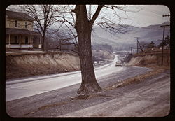
- While winding through Hampshire County, the Northwestern Turnpike passes through several historic communities, some of which with only a few old buildings remaining. These communities include JunctionJunction, West VirginiaJunction is an unincorporated community in Hampshire County in the U.S. state of West Virginia. Historically referred to as Moorefield Junction, Junction received its name because of its location at the crossroads of U.S. Highway 220/West Virginia Route 28 and the Northwestern Turnpike...
, MechanicsburgMechanicsburg, West VirginiaMechanicsburg is an unincorporated community in Hampshire County, West Virginia, in the United States. It is located on the Northwestern Turnpike west of Romney at Mill Creek Gap . Mechanicsburg is the site of "The Burg" , used as a headquarters by both armies during the American Civil War...
, VanderlipVanderlip, West VirginiaVanderlip is an unincorporated community in Hampshire County in the U.S. state of West Virginia. Vanderlip is located west of Romney along the Northwestern Turnpike and the South Branch Valley Railroad. At times the community was referred to as West Romney Station, while its post office used the...
, RomneyRomney, West VirginiaRomney is a city in and the county seat of Hampshire County, West Virginia, United States. The population was 1,940 at the 2000 census, while the area covered by the city's ZIP code had a population of 5,873. It is a city with a very historic background dating back to the 18th century...
, ShanksShanks, West VirginiaShanks is an unincorporated community in Hampshire County in the U.S. state of West Virginia. According to the 2000 census, the Shanks community has a population of 806....
, FrenchburgFrenchburg, West VirginiaFrenchburg is an unincorporated community in Hampshire County in the U.S. state of West Virginia. Frenchburg is located along the Northwestern Turnpike where the Little Cacapon River is formed by the confluence of the North and South forks of the Little Cacapon east of Shanks...
, AugustaAugusta, West VirginiaAugusta is an unincorporated community in central Hampshire County, West Virginia. It is located along the Northwestern Turnpike at the northern terminus of Augusta-Ford Hill Road between Shanks and Pleasant Dale, east of Romney...
, Pleasant DalePleasant Dale, West VirginiaPleasant Dale is an unincorporated community in Hampshire County in the U.S. state of West Virginia. Pleasant Dale is located between Capon Bridge and Augusta on the Northwestern Turnpike . Tearcoat Creek flows through Pleasant Dale and offers whitewater rafting in the Spring from the U.S. Route 50...
, Hanging RockHanging Rock, West VirginiaHanging Rock is an unincorporated community in Hampshire County in the U.S. state of West Virginia. Hanging Rock is named for the "Hanging Rock" outcrop that hangs over the Northwestern Turnpike . It should not be confused with the plural "Hanging Rocks" over the South Branch Potomac River north of...
, LoomLoom, West VirginiaLoom is an unincorporated community in Hampshire County, West Virginia, USA. Loom is located between Capon Bridge and Hanging Rock along the Northwestern Turnpike on the western flanks of Cooper Mountain...
and Capon BridgeCapon Bridge, West VirginiaCapon Bridge is a town located in eastern Hampshire County, West Virginia along the Northwestern Turnpike , approximately twenty miles west of Winchester, Virginia. As of the 2000 census, the town population was 2,178, 200 of which live within the town limits. Originally known as Glencoe, Capon...
.
|
|