
Salem, West Virginia
Encyclopedia
Salem is a city in Harrison County
, West Virginia
, United States
. The population was 2,006 at the 2000 census. It is located at the junction of U.S. Route 50
and West Virginia Route 23; the North Bend Rail Trail
passes through the city. Salem International University
is located in Salem.
of 2000, there were 2,006 people, 744 households, and 412 families residing in the city. The population density
was 1,451.0 people per square mile (561.2/km²). There were 858 housing units at an average density of 620.6 per square mile (240.1/km²). The racial makeup of the city was 87.39% White, 2.34% African American, 0.20% Native American, 7.93% Asian, 0.05% Pacific Islander, 0.75% from other races
, and 1.35% from two or more races. Hispanic or Latino of any race were 1.00% of the population.
There were 744 households out of which 26.5% had children under the age of 18 living with them, 37.6% were married couples
living together, 14.0% had a female householder with no husband present, and 44.5% were non-families. 36.7% of all households were made up of individuals and 15.9% had someone living alone who was 65 years of age or older. The average household size was 2.21 and the average family size was 2.92.
In the city the population was spread out with 18.3% under the age of 18, 25.2% from 18 to 24, 21.0% from 25 to 44, 18.3% from 45 to 64, and 17.1% who were 65 years of age or older. The median age was 31 years. For every 100 females there were 99.4 males. For every 100 females age 18 and over, there were 105.0 males.
The median income for a household in the city was $16,577, and the median income for a family was $27,688. Males had a median income of $27,031 versus $16,667 for females. The per capita income
for the city was $11,188. About 26.7% of families and 34.8% of the population were below the poverty line, including 40.6% of those under age 18 and 14.7% of those age 65 or over.
.
According to the United States Census Bureau
, the city has a total area of 1.4 square miles (3.6 km²), all of it land.
 Salem was settled by Seventh Day Baptists (the Davis and Randolph families among them).
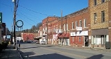
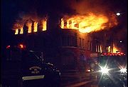
Salem has a history of large fires. The same full city block has burned down twice in the city's history. The north side of Main Street downtown burned once in 1901 and again on March 2, 2006. The more recent fire burned the old city bank building, several store fronts, and several residences; five structures in all were damaged. The fire was determined to have been started by a hot water tank in an apartment. The fire departments' ability to put out the blaze was hampered by a limited city water supply; they were forced to draw water from the nearby creek.
The Salem College Administration Building
and Salem Historic District
are listed on the National Register of Historic Places
.
Harrison County, West Virginia
As of the census of 2000, there were 68,652 people, 27,867 households, and 19,088 families residing in the county. The population density was 165 people per square mile . There were 31,112 housing units at an average density of 75 per square mile...
, West Virginia
West Virginia
West Virginia is a state in the Appalachian and Southeastern regions of the United States, bordered by Virginia to the southeast, Kentucky to the southwest, Ohio to the northwest, Pennsylvania to the northeast and Maryland to the east...
, United States
United States
The United States of America is a federal constitutional republic comprising fifty states and a federal district...
. The population was 2,006 at the 2000 census. It is located at the junction of U.S. Route 50
U.S. Route 50
U.S. Route 50 is a major east–west route of the U.S. Highway system, stretching just over from Ocean City, Maryland on the Atlantic Ocean to West Sacramento, California. Until 1972, when it was replaced by Interstate Highways west of the Sacramento area, it extended to San Francisco, near...
and West Virginia Route 23; the North Bend Rail Trail
North Bend Rail Trail
The North Bend Rail Trail is a rail trail in north-central and western West Virginia in the United States. It is operated by West Virginia State Parks and is part of the American Discovery Trail....
passes through the city. Salem International University
Salem International University
Salem International University is an American private university located in Salem, West Virginia, in the United States...
is located in Salem.
Demographics
As of the censusCensus
A census is the procedure of systematically acquiring and recording information about the members of a given population. It is a regularly occurring and official count of a particular population. The term is used mostly in connection with national population and housing censuses; other common...
of 2000, there were 2,006 people, 744 households, and 412 families residing in the city. The population density
Population density
Population density is a measurement of population per unit area or unit volume. It is frequently applied to living organisms, and particularly to humans...
was 1,451.0 people per square mile (561.2/km²). There were 858 housing units at an average density of 620.6 per square mile (240.1/km²). The racial makeup of the city was 87.39% White, 2.34% African American, 0.20% Native American, 7.93% Asian, 0.05% Pacific Islander, 0.75% from other races
Race (United States Census)
Race and ethnicity in the United States Census, as defined by the Federal Office of Management and Budget and the United States Census Bureau, are self-identification data items in which residents choose the race or races with which they most closely identify, and indicate whether or not they are...
, and 1.35% from two or more races. Hispanic or Latino of any race were 1.00% of the population.
There were 744 households out of which 26.5% had children under the age of 18 living with them, 37.6% were married couples
Marriage
Marriage is a social union or legal contract between people that creates kinship. It is an institution in which interpersonal relationships, usually intimate and sexual, are acknowledged in a variety of ways, depending on the culture or subculture in which it is found...
living together, 14.0% had a female householder with no husband present, and 44.5% were non-families. 36.7% of all households were made up of individuals and 15.9% had someone living alone who was 65 years of age or older. The average household size was 2.21 and the average family size was 2.92.
In the city the population was spread out with 18.3% under the age of 18, 25.2% from 18 to 24, 21.0% from 25 to 44, 18.3% from 45 to 64, and 17.1% who were 65 years of age or older. The median age was 31 years. For every 100 females there were 99.4 males. For every 100 females age 18 and over, there were 105.0 males.
The median income for a household in the city was $16,577, and the median income for a family was $27,688. Males had a median income of $27,031 versus $16,667 for females. The per capita income
Per capita income
Per capita income or income per person is a measure of mean income within an economic aggregate, such as a country or city. It is calculated by taking a measure of all sources of income in the aggregate and dividing it by the total population...
for the city was $11,188. About 26.7% of families and 34.8% of the population were below the poverty line, including 40.6% of those under age 18 and 14.7% of those age 65 or over.
Geography
Salem is located at 39°17′0"N 80°33′46"W (39.283411, -80.562731), along Salem Fork, a tributary of Tenmile CreekTenmile Creek (West Virginia)
Tenmile Creek is a tributary of the West Fork River, long, in north-central West Virginia in the United States. Via the West Fork, Monongahela and Ohio Rivers, it is part of the watershed of the Mississippi River, draining an area of on the unglaciated portion of the Allegheny Plateau.Tenmile...
.
According to the United States Census Bureau
United States Census Bureau
The United States Census Bureau is the government agency that is responsible for the United States Census. It also gathers other national demographic and economic data...
, the city has a total area of 1.4 square miles (3.6 km²), all of it land.
History
Salem has a history of large fires. The same full city block has burned down twice in the city's history. The north side of Main Street downtown burned once in 1901 and again on March 2, 2006. The more recent fire burned the old city bank building, several store fronts, and several residences; five structures in all were damaged. The fire was determined to have been started by a hot water tank in an apartment. The fire departments' ability to put out the blaze was hampered by a limited city water supply; they were forced to draw water from the nearby creek.
The Salem College Administration Building
Salem College Administration Building
Salem College Administration Building is a historic school administration building located on the campus of Salem International University at Salem, Harrison County, West Virginia. It was built in 1909-1910, and is 2 1/2-story, stone and brick building with a truncated hipped roof and full...
and Salem Historic District
Salem Historic District (Salem, West Virginia)
Salem Historic District is a national historic district located at Salem, Harrison County, West Virginia. The district encompasses 28 contributing buildings in the central business district developed after a devastating fire in 1902. The district is almost exclusively commercial, with the...
are listed on the National Register of Historic Places
National Register of Historic Places
The National Register of Historic Places is the United States government's official list of districts, sites, buildings, structures, and objects deemed worthy of preservation...
.
Notable natives
- Jennings RandolphJennings RandolphJennings Randolph was an American politician from West Virginia. He was a member of the Democratic Party and was the last surviving member of the United States Congress to have served during the first 100 days of Franklin D. Roosevelt's administration.-Early life and career:Randolph was born in...
: US Senator - Melvin MayfieldMelvin MayfieldMelvin Mayfield was a United States Army soldier and a recipient of the United States military's highest decoration—the Medal of Honor—for his actions in World War II.-Biography:...
: United States Army soldier and a recipient of the United States military's highest decoration—the Medal of Honor—for his actions in World War II.