
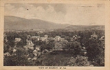
Romney, West Virginia
Encyclopedia
Romney is a city in and the county seat
of Hampshire County
, West Virginia
, United States. The population was 1,940 at the 2000 census
, while the area covered
by the city's ZIP code
had a population of 5,873. It is a city with a very historic background dating back to the 18th century. Originally settled in 1725 by hunters and traders, Romney was known as Pearsall's Flats and was the site of the French and Indian War
stockade Fort Pearsall
. Romney holds the title of West Virginia's oldest town
, chartered December 23, 1762. Named for the Cinque Ports
town of Romney
, Kent
, England by Thomas Fairfax, 6th Lord Fairfax of Cameron
, the town still bears placenames and symbols from its colonial past such as its Marsham Street, named for Robert Marsham
, 2nd Baron Romney. It is also home to the West Virginia Schools for the Deaf and Blind
and the nation's First Confederate Memorial
in Indian Mound Cemetery
.
According to the United States Census Bureau
, the city has a total area of 0.9 square miles (2.4 km²), all of it land.
of 2000, there were 1,940 people, 884 households, and 454 families residing in the city. The population density
was 2,114.3 people per square mile (814.2/km²). There were 974 housing units at an average density of 1,061.5 per square mile (408.8/km²). The racial makeup of the city was 96.91% White, 1.91% African American, 0.05% Native American, 0.52% Asian, 0.21% from other races
, and 0.41% from two or more races. Hispanic or Latino of any race were 0.67% of the population.
There were 884 households out of which 21.7% had children under the age of 18 living with them, 33.7% were married couples
living together, 14.6% had a female householder with no husband present, and 48.6% were non-families. 44.8% of all households were made up of individuals and 26.8% had someone living alone who was 65 years of age or older. The average household size was 1.97 and the average family size was 2.72.
In the city the population was spread out with 25.2% under the age of 18, 7.4% from 18 to 24, 20.1% from 25 to 44, 21.3% from 45 to 64, and 26.1% who were 65 years of age or older. The median age was 42 years. For every 100 females there were 76.2 males. For every 100 females age 18 and over, there were 68.5 males.
The median income for a household in the city was $22,261, and the median income for a family was $34,271. Males had a median income of $28,667 versus $20,000 for females. The per capita income
for the city was $15,765. About 17.2% of families and 24.6% of the population were below the poverty line, including 29.5% of those under age 18 and 18.2% of those age 65 or over.

County seat
A county seat is an administrative center, or seat of government, for a county or civil parish. The term is primarily used in the United States....
of Hampshire County
Hampshire County, West Virginia
Hampshire County is a county located in the U.S. state of West Virginia. As of 2010, the population was 23,964. Its county seat is Romney, West Virginia's oldest town . Hampshire County was created by the Virginia General Assembly on December 13, 1753, from parts of Frederick and Augusta counties ...
, West Virginia
West Virginia
West Virginia is a state in the Appalachian and Southeastern regions of the United States, bordered by Virginia to the southeast, Kentucky to the southwest, Ohio to the northwest, Pennsylvania to the northeast and Maryland to the east...
, United States. The population was 1,940 at the 2000 census
United States Census, 2000
The Twenty-second United States Census, known as Census 2000 and conducted by the Census Bureau, determined the resident population of the United States on April 1, 2000, to be 281,421,906, an increase of 13.2% over the 248,709,873 persons enumerated during the 1990 Census...
, while the area covered
ZIP Code Tabulation Area
ZIP Code Tabulation Areas are statistical entities developed by the United States Census Bureau for tabulating summary statistics from Census 2000. This new entity was developed to overcome the difficulties in precisely defining the land area covered by each ZIP code...
by the city's ZIP code
ZIP Code
ZIP codes are a system of postal codes used by the United States Postal Service since 1963. The term ZIP, an acronym for Zone Improvement Plan, is properly written in capital letters and was chosen to suggest that the mail travels more efficiently, and therefore more quickly, when senders use the...
had a population of 5,873. It is a city with a very historic background dating back to the 18th century. Originally settled in 1725 by hunters and traders, Romney was known as Pearsall's Flats and was the site of the French and Indian War
French and Indian War
The French and Indian War is the common American name for the war between Great Britain and France in North America from 1754 to 1763. In 1756, the war erupted into the world-wide conflict known as the Seven Years' War and thus came to be regarded as the North American theater of that war...
stockade Fort Pearsall
Fort Pearsall
Fort Pearsall was an early frontier fort constructed in 1756 in Romney, West Virginia to protect local settlers in the South Branch Potomac River valley against Native American raids...
. Romney holds the title of West Virginia's oldest town
West Virginia's oldest town
There has been a long-running dispute over which town in West Virginia is the oldest. The dispute between Shepherdstown and Romney goes back well before West Virginia even became a state....
, chartered December 23, 1762. Named for the Cinque Ports
Cinque Ports
The Confederation of Cinque Ports is a historic series of coastal towns in Kent and Sussex. It was originally formed for military and trade purposes, but is now entirely ceremonial. It lies at the eastern end of the English Channel, where the crossing to the continent is narrowest...
town of Romney
New Romney
New Romney is a small town in Kent, England, on the edge of Romney Marsh, an area of flat, rich agricultural land reclaimed from the sea after the harbour began to be silted up. New Romney was once a sea port, with the harbour adjacent to the church, but is now more than a mile from the sea...
, Kent
Kent
Kent is a county in southeast England, and is one of the home counties. It borders East Sussex, Surrey and Greater London and has a defined boundary with Essex in the middle of the Thames Estuary. The ceremonial county boundaries of Kent include the shire county of Kent and the unitary borough of...
, England by Thomas Fairfax, 6th Lord Fairfax of Cameron
Thomas Fairfax, 6th Lord Fairfax of Cameron
Thomas Fairfax, 6th Lord Fairfax of Cameron was the son of Thomas Fairfax, 5th Lord Fairfax of Cameron and of Catherine, daughter of Thomas Culpeper, 2nd Baron Culpeper of Thoresway....
, the town still bears placenames and symbols from its colonial past such as its Marsham Street, named for Robert Marsham
Robert Marsham
Robert Marsham was an English naturalist considered to be the founding father of phenology, the study of the effects of the seasons on plants and animals....
, 2nd Baron Romney. It is also home to the West Virginia Schools for the Deaf and Blind
West Virginia Schools for the Deaf and Blind
The West Virginia Schools for the Deaf and Blind were established by an Act of the Legislature on March 3, 1870. The School for the Deaf and the School for the Blind offer comprehensive educational programs for hearing impaired and visually impaired students respectively. There is also a unit for...
and the nation's First Confederate Memorial
First Confederate Memorial
The Confederate Memorial in Indian Mound Cemetery at Romney, West Virginia, is considered the first official memorial to Confederate dead to be erected anywhere in the United States of America.-History:...
in Indian Mound Cemetery
Indian Mound Cemetery
Indian Mound Cemetery is a cemetery located along the Northwestern Turnpike on a promontory of the "Yellow Banks" overlooking the South Branch Potomac River and Mill Creek Mountain in Romney, West Virginia, United States. The cemetery is centered around a Hopewellian mound, known as the Romney...
.
Geography
Romney is located at 39°20′42"N 78°45′25"W (39.344915, -78.756960).According to the United States Census Bureau
United States Census Bureau
The United States Census Bureau is the government agency that is responsible for the United States Census. It also gathers other national demographic and economic data...
, the city has a total area of 0.9 square miles (2.4 km²), all of it land.
Demographics
As of the censusCensus
A census is the procedure of systematically acquiring and recording information about the members of a given population. It is a regularly occurring and official count of a particular population. The term is used mostly in connection with national population and housing censuses; other common...
of 2000, there were 1,940 people, 884 households, and 454 families residing in the city. The population density
Population density
Population density is a measurement of population per unit area or unit volume. It is frequently applied to living organisms, and particularly to humans...
was 2,114.3 people per square mile (814.2/km²). There were 974 housing units at an average density of 1,061.5 per square mile (408.8/km²). The racial makeup of the city was 96.91% White, 1.91% African American, 0.05% Native American, 0.52% Asian, 0.21% from other races
Race (United States Census)
Race and ethnicity in the United States Census, as defined by the Federal Office of Management and Budget and the United States Census Bureau, are self-identification data items in which residents choose the race or races with which they most closely identify, and indicate whether or not they are...
, and 0.41% from two or more races. Hispanic or Latino of any race were 0.67% of the population.
There were 884 households out of which 21.7% had children under the age of 18 living with them, 33.7% were married couples
Marriage
Marriage is a social union or legal contract between people that creates kinship. It is an institution in which interpersonal relationships, usually intimate and sexual, are acknowledged in a variety of ways, depending on the culture or subculture in which it is found...
living together, 14.6% had a female householder with no husband present, and 48.6% were non-families. 44.8% of all households were made up of individuals and 26.8% had someone living alone who was 65 years of age or older. The average household size was 1.97 and the average family size was 2.72.
In the city the population was spread out with 25.2% under the age of 18, 7.4% from 18 to 24, 20.1% from 25 to 44, 21.3% from 45 to 64, and 26.1% who were 65 years of age or older. The median age was 42 years. For every 100 females there were 76.2 males. For every 100 females age 18 and over, there were 68.5 males.
The median income for a household in the city was $22,261, and the median income for a family was $34,271. Males had a median income of $28,667 versus $20,000 for females. The per capita income
Per capita income
Per capita income or income per person is a measure of mean income within an economic aggregate, such as a country or city. It is calculated by taking a measure of all sources of income in the aggregate and dividing it by the total population...
for the city was $15,765. About 17.2% of families and 24.6% of the population were below the poverty line, including 29.5% of those under age 18 and 18.2% of those age 65 or over.
History
| Historical populations | |
|---|---|
| Census year | Population |
| 1810 | 295 |
| 1850 | 456 |
| 1890 | 451 |
| 1900 | 580 |
| 1910 | 1,112 |
| 1920 | 1,028 |
| 1930 | 1,441 |
| 1940 | 2,013 |
| 1950 | 2,059 |
| 1960 | 2,203 |
| 1970 | 2,364 |
| 1980 | 2,094 |
| 1990 | 1,966 |
| 2000 | 1,940 |
| 2006 | 1,971 |
Historic sites
- Arnold House (1770) The families Millar, Parker, and Arnold are associated with this house built in 1770. It was the home of Isaac Millar, a prominent officer during the American Revolutionary WarAmerican Revolutionary WarThe American Revolutionary War , the American War of Independence, or simply the Revolutionary War, began as a war between the Kingdom of Great Britain and thirteen British colonies in North America, and ended in a global war between several European great powers.The war was the result of the...
, businessman and civic leader. - Blue House (1900) This has been home to descendants of Lieutenant John Blue, famed ConfederateConfederate States of AmericaThe Confederate States of America was a government set up from 1861 to 1865 by 11 Southern slave states of the United States of America that had declared their secession from the U.S...
spy, whose memoirs were published in Hanging Rock Rebel. - Boxwood (1800) Reportedly sold for about $10 for unpaid taxes, the house was used as an American Civil WarAmerican Civil WarThe American Civil War was a civil war fought in the United States of America. In response to the election of Abraham Lincoln as President of the United States, 11 southern slave states declared their secession from the United States and formed the Confederate States of America ; the other 25...
hospital. It is said that each of the 56 changes between the Northern and Southern armies during the Civil War in Romney took place under the great elm in the front yard. - The Buffalo House at Fern Cliff (early 19th century) Isaac Pancake built the original log portion in the early 19th century. Recently restored with additions made, it is the home of John and Barbara Pancake.
- The Burg (c. 1769) Built around 1769, this property has been in the original family (Williams) for seven generations. It was used as headquarters by both armies during the Civil War.
- Cookman Building (1906) Built originally as the Bank of Romney building and currently serves as the offices for the Hampshire Review newspaper.
- County Poor Farm (late 18th century) Originally a glebeGlebeGlebe Glebe Glebe (also known as Church furlong or parson's closes is an area of land within a manor and parish used to support a parish priest.-Medieval origins:...
-house for the local Episcopal church and then Hampshire County's "poor farm." - Davis History House (1798) The Davis House was home to the Davis family which sent two sons to fight for the Confederacy and one for the Union. Now a museum, it features Civil War artifacts and period furnishings.
- Farmer's Exchange (late 19th century) At one time Shorty Mauk's store, the Farmer's Exchange has served as a store for the Romney community in some capacity for over one hundred years. It was abandoned after a fire in recent years but is still standing. Located at the intersection of Bolton St. and Birch Ln.
- First Confederate MemorialFirst Confederate MemorialThe Confederate Memorial in Indian Mound Cemetery at Romney, West Virginia, is considered the first official memorial to Confederate dead to be erected anywhere in the United States of America.-History:...
(1867) - First United Methodist Church (1904)
- Green Meadows (c. 1900) This farm served as the first sweet corn truck farm in Hampshire County.
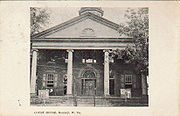
- Hampshire County CourthouseHampshire County Courthouse (West Virginia)The Hampshire County Courthouse is a Neoclassical edifice in the center of downtown Romney, county seat of Hampshire County, West Virginia. The present building was constructed in 1922 to replace the previous 1833 Neoclassical courthouse that had been destroyed by fire in 1921...
(1922) - Hickory Grove (1838) Adam Stump and wife, Mary Gregg Parsons, built the brick house in 1838. Their son, Captain George Stump, was killed by Yankee soldiers a short distance from his house just before the end of the war. The seventh generation of the family continue to live there. Hickory Grove is listed on the National Register of Historic PlacesNational Register of Historic PlacesThe National Register of Historic Places is the United States government's official list of districts, sites, buildings, structures, and objects deemed worthy of preservation...
. - Indian Mound CemeteryIndian Mound CemeteryIndian Mound Cemetery is a cemetery located along the Northwestern Turnpike on a promontory of the "Yellow Banks" overlooking the South Branch Potomac River and Mill Creek Mountain in Romney, West Virginia, United States. The cemetery is centered around a Hopewellian mound, known as the Romney...
- Kerns House (c. 1780) Now the home of the American LegionAmerican LegionThe American Legion is a mutual-aid organization of veterans of the United States armed forces chartered by the United States Congress. It was founded to benefit those veterans who served during a wartime period as defined by Congress...
, it was built by Hessian former prisoners of war soon after the American Revolutionary War ended. The front is Flemish bond construction, the sides of American bond. Much of the window glass is original. - Kuykendall-Hicks House (mid-18th century) The north portion of the present structure was Fort Kuykendall built during the French and Indian WarFrench and Indian WarThe French and Indian War is the common American name for the war between Great Britain and France in North America from 1754 to 1763. In 1756, the war erupted into the world-wide conflict known as the Seven Years' War and thus came to be regarded as the North American theater of that war...
. Additions were made in 1814 by Isaac Pancake and a two story addition was completed in 1987. - Liberty Hall (1858) Traditionally referred to as Thomas "Stonewall" Jackson's headquarters, the house and grounds were used by both Union and Confederate troops at various times during the Civil War. It was built in 1858 by John B. White, clerk of the circuit and superior court in Hampshire County, who fled to RichmondRichmond, VirginiaRichmond is the capital of the Commonwealth of Virginia, in the United States. It is an independent city and not part of any county. Richmond is the center of the Richmond Metropolitan Statistical Area and the Greater Richmond area...
to escape arrest and served in the Treasury Department of the Confederacy. - Literary HallLiterary HallLiterary Hall is the historic former site of the Romney Literary Society and currently serves as a museum featuring local memorabilia in Romney, West Virginia, United States.-Romney Literary Society and the First Literary Hall:...
(1870) As a meeting place of the Literary Society, it housed the largest library west of the Blue Ridge MountainsBlue Ridge MountainsThe Blue Ridge Mountains are a physiographic province of the larger Appalachian Mountains range. This province consists of northern and southern physiographic regions, which divide near the Roanoke River gap. The mountain range is located in the eastern United States, starting at its southern-most...
. On the National Register of Historic PlacesNational Register of Historic PlacesThe National Register of Historic Places is the United States government's official list of districts, sites, buildings, structures, and objects deemed worthy of preservation...
, it features antique firearms, music boxes, and period furnishings. - Mount Pisgah Benevolence CemeteryMount Pisgah Benevolence CemeteryMount Pisgah Benevolence Cemetery is an African-American cemetery in Romney, West Virginia, United States. The cemetery is located along the Northwestern Turnpike below Indian Mound Cemetery overlooking Sulphur Spring Run...
- Pancake-Kuykendall House (1872) Situated on lot 12 of the Fairfax South Branch River Survey, it was built in 1872 by Joseph A. and Susan Parsons Pancake. Third generation Pancake family continue to live there.
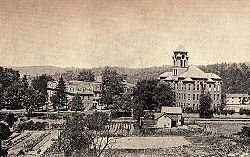
- Romney Classical Institute (1846) Extensively remodeled after 1870 when it became the administration building for the West Virginia Schools for the Deaf and BlindWest Virginia Schools for the Deaf and BlindThe West Virginia Schools for the Deaf and Blind were established by an Act of the Legislature on March 3, 1870. The School for the Deaf and the School for the Blind offer comprehensive educational programs for hearing impaired and visually impaired students respectively. There is also a unit for...
. Wings were added to the original Institute and another building was added in 1900 (the taller building in the picture shown to the right). - Old Romney High School (1930) Originally built as a high school to replace the Old Romney Public School, and then converted into a junior high in the 1960s after the creation of Hampshire High School, and then into a middle school until the new Romney Middle SchoolRomney Middle SchoolRomney Middle School located in Romney, West Virginia, is a West Virginia public school that serves approximately 525 students in grades 6 through 8 under the direction of ]]...
was opened in December 2004. [History of Romney Middle School]http://rms.hamp.k12.wv.us/history/ Now is used as a building for Romney Elementary School. - Romney Presbyterian Church (1860) It was used as a hospital and stable during the Civil War. Originally it had a bell tower and steeple, but those were removed because of the weakened condition of the building. Iron rails outside and rods inside were added to reinforce the walls.
- Saint Stephen's Episcopal Church (1885) Built in 1885 for $1800, this small brick church features Gothic windows and tiny porticos. The TiffanyTiffany glassTiffany glass refers to the many and varied types of glass developed and produced from 1878 to 1933 at the Tiffany Studios, by Louis Comfort Tiffany....
-style alter window is in memory of the minister who served from 1886 to 1915. The marble baptismal font predates the church building. - School House (1825) Built as a church around 1825, it suffered a fire in 1853. From 1866 to 1906 it served as public school, with primary grades continuing to be housed there for some time after. It became a private home in 1914.
- Sycamore DaleSycamore DaleSycamore Dale is a 19th-century Greek Revival plantation home overlooking the South Branch Potomac River southwest of Romney, West Virginia. Sycamore Dale is one of several historic estates along South Branch River Road...
(1836) Referred to in the General Lew WallaceLew WallaceLewis "Lew" Wallace was an American lawyer, Union general in the American Civil War, territorial governor and statesman, politician and author...
raid of June 12, 1861, Sycamore Dale was built by David Gibson in 1836. The house is listed on the National Register of Historic PlacesNational Register of Historic PlacesThe National Register of Historic Places is the United States government's official list of districts, sites, buildings, structures, and objects deemed worthy of preservation...
. Wallace wrote a portion of Ben-Hur: A Tale of the ChristBen-Hur (novel)Ben-Hur: A Tale of the Christ is a novel by Lew Wallace published on November 12, 1880 by Harper & Brothers. Considered "the most influential Christian book of the nineteenth century", it was the best-selling American novel from the time of its publication, superseding Harriet Beecher Stowe's...
here. - Taggart HallTaggart HallTaggart Hall Civil War Museum & Visitors Center is home to the Fort Mill Ridge Foundation and its Fort Mill Ridge Civil War Trenches museum, the Hampshire County Visitors Bureau, and the Hampshire County Chamber of Commerce. It is located in Romney, West Virginia at 91 South High Street...
(c. 1790s) Frances Taggart, a Quaker, constructed this clapboard "half" house on a lot from the Lord Fairfax survey. It now serves as headquarters for the Fort Mill Ridge Foundation Museum & Exhibit Center. - Valley View (1855) Built for Hannah Parsons Harlan by her father, James "Big Jim" Parsons. Sold in 1927 to Joseph O'Hara, who was instrumental in bringing electric power to Romney. Currently a private home.
- Van Meter FortFort Van MeterFort Van Meter — also known as Fort Pleasant and Town Fort — was an 18th century frontier fort in the South Branch Potomac River Valley south of Romney in Hampshire County, West Virginia, USA. It is located approximately a mile and a half north of the rugged river gorge known as The Trough...
(1754) Used as a French and Indian WarFrench and Indian WarThe French and Indian War is the common American name for the war between Great Britain and France in North America from 1754 to 1763. In 1756, the war erupted into the world-wide conflict known as the Seven Years' War and thus came to be regarded as the North American theater of that war...
fort, this structure is adjacent to the Kuykendall house. It shows the gun slits and relatively fireproof construction. Its surviving blockhouse is listed in the National Register of Historic PlacesNational Register of Historic PlacesThe National Register of Historic Places is the United States government's official list of districts, sites, buildings, structures, and objects deemed worthy of preservation...
. - WappocomoWappocomo (plantation)Wappocomo is a late 18th-century Georgian mansion overlooking the South Branch Potomac River north of Romney, West Virginia, United States. Wappocomo lies along West Virginia Route 28 and the South Branch Valley Railroad...
(1774) The main part of the house was built in 1774 from bricks used as ballastSailing ballastBallast is used in sailboats to provide moment to resist the lateral forces on the sail. Insufficiently ballasted boats will tend to tip, or heel, excessively in high winds. Too much heel may result in the boat capsizing. If a sailing vessel should need to voyage without cargo then ballast of...
on English ships, off-loaded at Newport NewsNewport News, VirginiaNewport News is an independent city located in the Hampton Roads metropolitan area of Virginia. It is at the southeastern end of the Virginia Peninsula, on the north shore of the James River extending southeast from Skiffe's Creek along many miles of waterfront to the river's mouth at Newport News...
, and hauled across the mountains by oxen. It has been home to six generations of the original family. - Washington PlaceWashington Place (West Virginia)Washington Place is one of the first homes built by freed slaves after the Emancipation Proclamation of 1863 in Hampshire County, West Virginia, United States...
(late 19th century) Restored cabin built by the Washingtons, a family of freed slaves. - Wilson-Wodrow-Mytinger HouseWilson-Wodrow-Mytinger HouseThe Wilson-Wodrow-Mytinger House is believed to be the oldest house in Romney and the oldest public office building in the U.S. state of West Virginia...
(c. 1760) Romney's oldest house features three buildings. The main house reflects architecture of the JamestownJamestown, VirginiaJamestown was a settlement in the Colony of Virginia. Established by the Virginia Company of London as "James Fort" on May 14, 1607 , it was the first permanent English settlement in what is now the United States, following several earlier failed attempts, including the Lost Colony of Roanoke...
area. The clerk's office, West Virginia's oldest public office building, 1788, was constructed in a WilliamsburgWilliamsburg, VirginiaWilliamsburg is an independent city located on the Virginia Peninsula in the Hampton Roads metropolitan area of Virginia, USA. As of the 2010 Census, the city had an estimated population of 14,068. It is bordered by James City County and York County, and is an independent city...
. These structures are listed in the National Register of Historic PlacesNational Register of Historic PlacesThe National Register of Historic Places is the United States government's official list of districts, sites, buildings, structures, and objects deemed worthy of preservation...
.
Parks and recreation
- Hampshire High School Sports Complex, US Route 50 East
- Baseball Field, Cross Country Trails, Running Track, Soccer Field, Softball Field
- Hampshire Park & 4-H Camp, South Branch River Road (CR 8)
- Picnic Pavilions, Baseball Field, Basketball Court, Volleyball Court, Tennis Courts
- Old Romney High School, 111 School Street
- Baseball Field, Basketball Courts, Football Field, Running Track
- Romney Recreation Center, 260 School Street
- Swimming Facilities
- West Virginia Schools for the Deaf and BlindWest Virginia Schools for the Deaf and BlindThe West Virginia Schools for the Deaf and Blind were established by an Act of the Legislature on March 3, 1870. The School for the Deaf and the School for the Blind offer comprehensive educational programs for hearing impaired and visually impaired students respectively. There is also a unit for...
Grounds, East Main Street- Baseball Field, Basketball Courts, Picnic Pavilions, Running Track, Soccer Field, Swimming Facilities
City of Romney links
- www.RomneyWV.com
- Hampshire County Schools
- Romney Elementary School
- Romney Middle School
- Hampshire County Chamber of Commerce
- Hampshire Review Newspaper
- Hampshire County History Homepage
- Hampshire County Public Library
- Hampshire High School
- West Virginia School for the Deaf & Blind Homepage