
Northern Oregon Coast Range
Encyclopedia
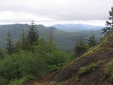
The Northern Oregon Coast Range is the northern section of the Oregon Coast Range
, in the Pacific Coast Ranges
physiographic region
, located in the northwest portion of the state of Oregon
, United States
. This section of the mountain range, part of the Pacific Coast Ranges
, contains peaks as high as 3661 feet (1,116 m) for Rogers Peak
. Forests in these mountains are considered to be some of the most productive timber land in the world. The Central Oregon Coast Range
is directly south of this section with the Southern Oregon Coast Range
beyond the central range.
age. During this time-period, sandstone and siltstone formed in the area. Additionally, igneous rocks and basalt flows combined with basaltic sandstone
to create many of the mountainous formations. Other sedimentary rock in the area formed more recently, around 20 million years ago. It is hypothesized that portions of the northern section of the range were islands during parts of the Eocene era. Other portions of the mountains consist of marine sedimentary rock. The entire coast range sits on a convergent tectonic margin interacting with the Juan de Fuca Plate
that is subducting beneath North America tectonic plate. Also, erosion of the region is a major factor in shaping the landscape. Heavy rainfall and landslides have worked to erode the mountains.
The range is part of a broad, plunging structural arch of sedimentary and Tertiary volcanic strata that is being uplifted. Eocene and Miocene
sections form the flanks of the uplifted sections. Some of the oldest rocks are submarine tholeiitic basalts from the Eocene era. The basalt
came from the basalt flows that covered much of Oregon and originated from volcanoes in the central portion of the state. Other rocks include sandstone, mudstone, and siltstone. It was during the middle Miocene period that the range was uplifted in the broad, northeast-plunging arch.
 Portions of the range are in the Siuslaw National Forest
and Tillamook State Forest
, and large sections of the range were burned in forest fires during the 1930s and 1940s as part of the Tillamook Burn
. In the forested areas trees include Sitka spruce, western redcedar, Douglas-fir
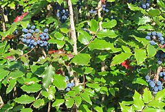
, and western hemlock. Other plants that grow in the region are huckleberry, salmonberry, salal, vine maple, sword fern, Oregon grape, bracken fern, and thimble-berry to name a few.
Insects found include millipedes, collembolans, spiders, beetles, slugs, and various centipedes. Animals that inhabit the Northern Coast range are weevils, chipmunks, bears, rabbits, white-footed deer mice, Columbian Black tail deer
, and others. Birds include chickadees, red-breasted nuthatches, kinglets, Western pileated woodpeckers, Oregon gray jays, California creepers, and Sitka red crossbills among others.
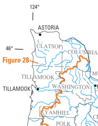
, with some mountainous features on the north side of the river, and continues south roughly 100 miles (160.9 km) to the Salmon River
where Oregon Route 18 traverses the range from the Willamette Valley
to the Oregon Coast
. The width of the range varies but is roughly 35 miles (56.3 km).
Climate of the range is moderate because of marine influences. Annual precipitation varies from 60 to 180 in (152.4 to 457.2 cm).
 The following rivers have their headwaters in the Northern Oregon Coast Range:
Oregon Coast Range
The Oregon Coast Range, often called simply the Coast Range and sometimes the Pacific Coast Range, is a mountain range, in the Pacific Coast Ranges physiographic region, in the U.S. state of Oregon along the Pacific Ocean...
, in the Pacific Coast Ranges
Pacific Coast Ranges
The Pacific Coast Ranges and the Pacific Mountain System are the series of mountain ranges that stretch along the West Coast of North America from Alaska south to Northern and Central Mexico...
physiographic region
Physiographic regions of the world
The physiographic regions of the world are a means of defining the Earth's landforms into distinct regions based upon classic 1916 three-tiered approach defining divisions, provinces, and sections...
, located in the northwest portion of the state of Oregon
Oregon
Oregon is a state in the Pacific Northwest region of the United States. It is located on the Pacific coast, with Washington to the north, California to the south, Nevada on the southeast and Idaho to the east. The Columbia and Snake rivers delineate much of Oregon's northern and eastern...
, United States
United States
The United States of America is a federal constitutional republic comprising fifty states and a federal district...
. This section of the mountain range, part of the Pacific Coast Ranges
Pacific Coast Ranges
The Pacific Coast Ranges and the Pacific Mountain System are the series of mountain ranges that stretch along the West Coast of North America from Alaska south to Northern and Central Mexico...
, contains peaks as high as 3661 feet (1,116 m) for Rogers Peak
Rogers Peak
Rogers Peak is the highest mountain in Tillamook County, Oregon. Located in the Tillamook State Forest, the peak is also the highest peak in the Northern Oregon Coast Range, which is the northern section of the Oregon Coast Range.- Geology :...
. Forests in these mountains are considered to be some of the most productive timber land in the world. The Central Oregon Coast Range
Central Oregon Coast Range
The Central Oregon Coast Range is the middle section of the Oregon Coast Range, in the Pacific Coast Ranges physiographic region, and located in the west-central portion of the state of Oregon, United States roughly between the Salmon River and the Umpqua River and the Willamette Valley and the...
is directly south of this section with the Southern Oregon Coast Range
Southern Oregon Coast Range
The Southern Oregon Coast Range is the southernmost section of the Oregon Coast Range, in the Pacific Coast Ranges, located in the southwest portion of the state of Oregon, United States roughly between the Umpqua River and the middle fork of the Coquille River, beyond which are the Klamath...
beyond the central range.
Geology
The origins of these mountains began approximately 40 million years ago during the EoceneEocene
The Eocene Epoch, lasting from about 56 to 34 million years ago , is a major division of the geologic timescale and the second epoch of the Paleogene Period in the Cenozoic Era. The Eocene spans the time from the end of the Palaeocene Epoch to the beginning of the Oligocene Epoch. The start of the...
age. During this time-period, sandstone and siltstone formed in the area. Additionally, igneous rocks and basalt flows combined with basaltic sandstone
Sandstone
Sandstone is a sedimentary rock composed mainly of sand-sized minerals or rock grains.Most sandstone is composed of quartz and/or feldspar because these are the most common minerals in the Earth's crust. Like sand, sandstone may be any colour, but the most common colours are tan, brown, yellow,...
to create many of the mountainous formations. Other sedimentary rock in the area formed more recently, around 20 million years ago. It is hypothesized that portions of the northern section of the range were islands during parts of the Eocene era. Other portions of the mountains consist of marine sedimentary rock. The entire coast range sits on a convergent tectonic margin interacting with the Juan de Fuca Plate
Juan de Fuca Plate
The Juan de Fuca Plate, named after the explorer of the same name, is a tectonic plate, generated from the Juan de Fuca Ridge, and subducting under the northerly portion of the western side of the North American Plate at the Cascadia subduction zone...
that is subducting beneath North America tectonic plate. Also, erosion of the region is a major factor in shaping the landscape. Heavy rainfall and landslides have worked to erode the mountains.
The range is part of a broad, plunging structural arch of sedimentary and Tertiary volcanic strata that is being uplifted. Eocene and Miocene
Miocene
The Miocene is a geological epoch of the Neogene Period and extends from about . The Miocene was named by Sir Charles Lyell. Its name comes from the Greek words and and means "less recent" because it has 18% fewer modern sea invertebrates than the Pliocene. The Miocene follows the Oligocene...
sections form the flanks of the uplifted sections. Some of the oldest rocks are submarine tholeiitic basalts from the Eocene era. The basalt
Basalt
Basalt is a common extrusive volcanic rock. It is usually grey to black and fine-grained due to rapid cooling of lava at the surface of a planet. It may be porphyritic containing larger crystals in a fine matrix, or vesicular, or frothy scoria. Unweathered basalt is black or grey...
came from the basalt flows that covered much of Oregon and originated from volcanoes in the central portion of the state. Other rocks include sandstone, mudstone, and siltstone. It was during the middle Miocene period that the range was uplifted in the broad, northeast-plunging arch.
Flora and fauna
Siuslaw National Forest
Siuslaw National Forest is a national forest in western Oregon, United States. Established in 1908, the Siuslaw is made up of a wide variety of ecosystems, ranging from coastal forests to sand dunes.- Geography :...
and Tillamook State Forest
Tillamook State Forest
The Tillamook State Forest is a publicly owned forest in the U.S. state of Oregon. Managed by the Oregon Department of Forestry, it is located west of Portland in the Northern Oregon Coast Range, and spans Washington, Tillamook, Yamhill, and Clatsop counties. The forest receives large amounts of...
, and large sections of the range were burned in forest fires during the 1930s and 1940s as part of the Tillamook Burn
Tillamook Burn
The Tillamook Burn was a series of forest fires in the Northern Oregon Coast Rangeof Oregon in the United States that destroyed a total area of 355,000 acres of old growth timber in what is now known as the Tillamook State Forest. The fires spanned the years of 1933–1951. By association, the name...
. In the forested areas trees include Sitka spruce, western redcedar, Douglas-fir
Douglas-fir
Douglas-fir is one of the English common names for evergreen coniferous trees of the genus Pseudotsuga in the family Pinaceae. Other common names include Douglas tree, and Oregon pine. There are five species, two in western North America, one in Mexico, and two in eastern Asia...
, and western hemlock. Other plants that grow in the region are huckleberry, salmonberry, salal, vine maple, sword fern, Oregon grape, bracken fern, and thimble-berry to name a few.
Insects found include millipedes, collembolans, spiders, beetles, slugs, and various centipedes. Animals that inhabit the Northern Coast range are weevils, chipmunks, bears, rabbits, white-footed deer mice, Columbian Black tail deer
Black-tailed Deer
Two forms of black-tailed deer or blacktail deer occupying coastal temperate rainforest on North America's Pacific coast are subspecies of the mule deer. They have sometimes been treated as a species, but virtually all recent authorities maintain they are subspecies...
, and others. Birds include chickadees, red-breasted nuthatches, kinglets, Western pileated woodpeckers, Oregon gray jays, California creepers, and Sitka red crossbills among others.
Location and climate
The range begins at the Columbia RiverColumbia River
The Columbia River is the largest river in the Pacific Northwest region of North America. The river rises in the Rocky Mountains of British Columbia, Canada, flows northwest and then south into the U.S. state of Washington, then turns west to form most of the border between Washington and the state...
, with some mountainous features on the north side of the river, and continues south roughly 100 miles (160.9 km) to the Salmon River
Salmon River (Lincoln County, Oregon)
The Salmon River flows from the Central Oregon Coast Range to the Pacific Ocean coast of northwest Oregon in the United States. About long, it begins and ends in Lincoln County but also flows briefly through western Polk and southern Tillamook counties....
where Oregon Route 18 traverses the range from the Willamette Valley
Willamette Valley
The Willamette Valley is the most populated region in the state of Oregon of the United States. Located in the state's northwest, the region is surrounded by tall mountain ranges to the east, west and south and the valley's floor is broad, flat and fertile because of Ice Age conditions...
to the Oregon Coast
Oregon Coast
The Oregon Coast is a region of the U.S. state of Oregon. It runs generally north-south along the Pacific Ocean, forming the western border of the state; the region is bounded to the east by the Oregon Coast Range. The Oregon Coast stretches approximately from the Columbia River in the north to...
. The width of the range varies but is roughly 35 miles (56.3 km).
Climate of the range is moderate because of marine influences. Annual precipitation varies from 60 to 180 in (152.4 to 457.2 cm).
Peaks
All mountains over 3000 feet (914.4 m) in elevation in the Northern Coast Range.| Mountain Name | Elevation | County | |
|---|---|---|---|
| feet | metres | ||
| Rogers Peak Rogers Peak Rogers Peak is the highest mountain in Tillamook County, Oregon. Located in the Tillamook State Forest, the peak is also the highest peak in the Northern Oregon Coast Range, which is the northern section of the Oregon Coast Range.- Geology :... |
3706 | 1,129.6 | Tillamook |
| South Saddle Mountain South Saddle Mountain South Saddle Mountain is the tallest mountain in Washington County, Oregon.Part of the Oregon Coast Range, the peak is located in the Tillamook State Forest in the northwest section of the state of Oregon. It is the eighth highest peak of the Oregon Coast Range.- History :South Saddle Mountain is... |
3465 | 1,056.1 | Washington |
| Larch Mountain Larch Mountain (Washington County, Oregon) Larch Mountain is a mountain in the Northern Oregon Coast Range in Washington County, Oregon, United States. It is located near Timber, on Oregon Route 6.... |
3452 | 1,052.2 | Washington |
| Trask Mountain Trask Mountain Trask Mountain in the Northern Oregon Coast Range, is the tallest mountain in Yamhill County, Oregon.It is located in the northwest corner of the county.... |
3426 | 1,044.2 | Yamhill |
| Saddle Mountain Saddle Mountain (Clatsop County, Oregon) Saddle Mountain is the tallest mountain in Clatsop County, Oregon. Part of the Oregon Coast Range, Saddle Mountain is in Saddle Mountain State Natural Area in the northwest corner of Oregon... |
3288 | 1,002.2 | Clatsop |
| Triangulation Point | 3235 | 986 | Tillamook |
| Kings Mountain | 3192 | 972.9 | Tillamook |
| Mount Hebo Mount Hebo Mount Hebo is a mountain located on the border of Tillamook County and Yamhill County in the U.S. state of Oregon. Mount Hebo is known for being one of the best, most easily accessed viewpoints in the north Oregon Coast, with a 360-degree view from the summit.... |
3154 | 961.3 | Yamhill |
| Edwards Butte | 3136 | 955.9 | Tillamook |
| Buck Mountain | 3097 | 944 | Tillamook |
| Sheridan Peak | 3091 | 942.1 | Yamhill |
| Woods Point | 3084 | 940 | Tillamook |
| Gobblers Knob | 3058 | 932.1 | Tillamook |
| Onion Peak | 3057 | 931.8 | Clatsop |
Other peaks
- Round Top (Oregon)Round Top (Oregon)Round Top is a mountain in Washington County, Oregon in the Northern Oregon Coast Range and is located west of Timber, on Oregon Route 6 and south of South Saddle Mountain.From 1933 to 1946, the summit was the site of a fire lookout tower and cabin....
2982 feet (908.9 m) - Neahkahnie MountainNeahkahnie MountainNeahkahnie Mountain is a mountain on the Oregon Coast, north of Manzanita in Oswald West State Park overlooking U.S. Route 101. The peak is part of the Northern Oregon Coast Range, which is part of the Oregon Coast Range...
1634 feet (498 m)
Rivers
- Drains to Columbia RiverColumbia RiverThe Columbia River is the largest river in the Pacific Northwest region of North America. The river rises in the Rocky Mountains of British Columbia, Canada, flows northwest and then south into the U.S. state of Washington, then turns west to form most of the border between Washington and the state...
:- Clatskanie RiverClatskanie RiverThe Clatskanie River is a tributary of the Columbia River, approximately long, in northwestern Oregon in the United States. It drains a timber-producing area in the foothills of the Northern Oregon Coast Range north-northwest of Portland....
- John Day RiverJohn Day River (northwestern Oregon)The John Day River is a tributary of the Columbia River, approximately long, in northwestern Oregon in the United States. The river is one of two tributaries of the Columbia in Oregon to bear the name "John Day River". The other John Day River, east of the Cascade Range, is much longer and more...
- Klaskanine RiverKlaskanine RiverThe Klaskanine River is a tributary of the Youngs River, approximately long, in northwest Oregon in the United States. It drains a small section of the Coast Range in the extreme northwest corner of the state in the watershed of the nearby Columbia River....
- Lewis and Clark RiverLewis and Clark RiverThe Lewis and Clark River is a tributary of the Columbia River, approximately long, in northwest Oregon in the United States. It drains of the Northern Oregon Coast Range in the extreme northwest corner of the state, entering the Columbia near its mouth. Near the river's mouth is the site of...
- Skipanon RiverSkipanon RiverThe Skipanon River is a tributary of the Columbia River, approximately long, on the Pacific coast of northwest Oregon in the United States. It is the last tributary of the Columbia on the Oregon side, draining an area of coastal bottom land bordered by sand dunes and entering the river from the...
- Wallooskee RiverWallooskee RiverThe Wallooskee River is a tributary of the Youngs River, about long, in northwest Oregon in the United States. It drains a small area of the foothills of the Coast Range near the mouth of the Columbia River. The Youngs River is a tributary of the Columbia River.It rises southwest of Astoria in a...
- Youngs RiverYoungs RiverThe Youngs River is a tributary of the Columbia River, approximately long, in northwest Oregon in the United States. It drains part of the Northern Oregon Coast Range in the extreme northwest corner of state, entering the Columbia just upstream from its mouth.It rises in a remote section of the...
- Clatskanie River
- Drains to Willamette RiverWillamette RiverThe Willamette River is a major tributary of the Columbia River, accounting for 12 to 15 percent of the Columbia's flow. The Willamette's main stem is long, lying entirely in northwestern Oregon in the United States...
:- Tualatin RiverTualatin RiverThe Tualatin River is a tributary of the Willamette River located in Oregon in the United States. The river is approximately long, and it drains a fertile farming region called the Tualatin Valley southwest and west of Portland at the northwest corner of the Willamette Valley...
- Yamhill RiverYamhill RiverThe Yamhill River is an tributary of the Willamette River, in the U.S. state of Oregon. Formed by the confluence of the South Yamhill River and the North Yamhill River about east of McMinnville, it drains part of the Northern Oregon Coast Range...
- Tualatin River
- Drains to Pacific OceanPacific OceanThe Pacific Ocean is the largest of the Earth's oceanic divisions. It extends from the Arctic in the north to the Southern Ocean in the south, bounded by Asia and Australia in the west, and the Americas in the east.At 165.2 million square kilometres in area, this largest division of the World...
:- Kilchis RiverKilchis RiverThe Kilchis River is a stream, about long, near the coast of northwest Oregon in the United States. It drains a mountainous timbered region of about in the Northern Oregon Coast Range west of Portland....
- Miami RiverMiami River (Oregon)The Miami River is a stream, approximately long, on the coast of northwest Oregon in the United States. It drains a mountainous timbered region of the Northern Oregon Coast Range west of Portland, into Pacific Ocean....
- Necanicum RiverNecanicum RiverThe Necanicum River is river on the Pacific coast of northwest Oregon in the United States, approximately long. It drains a timber-producing area of the Northern Oregon Coast Range northwest of Portland...
- Nehalem RiverNehalem RiverThe Nehalem River is a river on the Pacific coast of northwest Oregon in the United States, approximately long. It drains part of the Northern Oregon Coast Range northwest of Portland, originating on the east side of the mountains and flowing in a loop around the north end of the range near the...
- Nestucca RiverNestucca RiverThe Nestucca River flows for about through forests near the Pacific coast of northwest Oregon in the United States. It drains a timber-producing area of the Northern Oregon Coast Range west of Portland....
- Salmonberry RiverSalmonberry RiverThe Salmonberry River is a tributary of the Nehalem River, approximately 20 mi long, in northwest Oregon in the United States. It drains a remote unpopulated area of the Northern Oregon Coast Range in the Tillamook State Forest approximately 65 mi WNW of Portland...
- Salmon RiverSalmon River (Lincoln County, Oregon)The Salmon River flows from the Central Oregon Coast Range to the Pacific Ocean coast of northwest Oregon in the United States. About long, it begins and ends in Lincoln County but also flows briefly through western Polk and southern Tillamook counties....
- Tillamook RiverTillamook RiverThe Tillamook River is a stream, about long, near the coast of northwest Oregon in the United States. It drains an oceanside valley in the foothills of the Northern Oregon Coast Range west of Portland and empties into the Pacific Ocean via Tillamook Bay...
- Trask RiverTrask RiverThe Trask River is in northwestern Oregon in the United States. It drains a mountainous timber-producing area of the Northern Oregon Coast Range west of Portland into Tillamook Bay and the Pacific Ocean...
- Wilson RiverWilson River (Oregon)The Wilson River is a stream, about long, that flows from the Northern Oregon Coast Range to Tillamook Bay in the U.S. state of Oregon. Formed by the confluence of its Devil's Lake Fork and its South Fork, it runs generally west through the Tillamook State Forest to its mouth near the city of...
- Kilchis River