
Maribyrnong, Victoria
Encyclopedia
Maribyrnong is a suburb 8 km north-west of Melbourne
, Victoria
, Australia
. Its Local Government Area is the City of Maribyrnong
, part of River Ward. At the 2006 Census, Maribyrnong had a population of 8242.
Maribyrnong takes its name from the Maribyrnong River
which bounds the suburb to the north and east. Its other borders are Williamson Road, Rosamond Road, Mephan Street and Owen Street to the south.
Maribyrnong contains Highpoint Shopping Centre
, one of Australia's largest shopping centres. The suburb is also home to the Anglers Tavern Hotel , located on the banks of the Maribyrnong River. The hotel is a popular night spot and eatery for locals and Melbournians alike.
.
Maribyrnong is home to the Department of Defence ammunitions factory and storage facility. Although many of the buildings are now disused, the site has now been earmarked for development by the State Government for housing and low density commercial infrastructure.
Maribyrnong contains several schools, both Catholic and State Government run. Maribyrnong College
(est 1958) is the sole high school in the suburb, which recently underwent significant renovations by the State Government. St Margarets Catholic Primary School and nearby Footscray North Primary School both cater for primary school aged children in the area.
There are also various kindergarten and child care centers dotted in and around Maribyrnong.
 Many native species exist along the Maribyrnong River
. Some species thrive in the area. The most noticeable are;
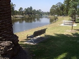
Maribyrnong has numerous parks dotted mostly near the Maribyrnong River. These reservers are typically unsuitable for development due to the risk of flooding and thus have been established as gardens and reserves for locals to enjoy.
throughout the entire suburb of Maribyrnong - a church in the Roman Catholic tradition. St Margaret's which is the namesake of the Catholic primary school is part of the Parish of Ascot Vale, and shares the same priest which conducts services at St Mary's in Ascot Vale.
matches.
tram provides public transport from Flinders Street Station
(Elizabeth & Flinders Streets) in the city to West Maribyrnong running through Ascot Vale
, Flemington
and North Melbourne
.
The Route 82
tram provides public transport from Moonee Ponds
(Ascot Vale Road & Puckle Street) to Footscray
(Leeds & Irving Streets). It is one of only three Melbourne tram routes which does not travel through the Melbourne CBD.
, runs just north of Maribyrnong along Buckley Street in Essendon.
Bus Lines running through Maribyrnong include the 215, 223, 406, 407, 408, 409, and 468.
which is used by commuting and recreational cyclists along the Maribyrnong River
. There are also numerous bike and walking trails which link the suburb to various other suburbs and take in some of the western suburbs greatest natural beauties, such as Pipemakers Park, Afton Street Conservation Park and Footscray Park.
The largest development to be announced by the State Government is the 128 hectare Defence site of the Maribyrnong Explosives Factory, bound by the Maribyrnong river. 3,000 new homes are expected to be built, along with open parkland, shops and the inclusion of many decade old defence buildings in keeping with heritage. Construction is expected to commence is 2012 with the project taking 10 – 15 years to be fully completed.
Melbourne
Melbourne is the capital and most populous city in the state of Victoria, and the second most populous city in Australia. The Melbourne City Centre is the hub of the greater metropolitan area and the Census statistical division—of which "Melbourne" is the common name. As of June 2009, the greater...
, Victoria
Victoria (Australia)
Victoria is the second most populous state in Australia. Geographically the smallest mainland state, Victoria is bordered by New South Wales, South Australia, and Tasmania on Boundary Islet to the north, west and south respectively....
, Australia
Australia
Australia , officially the Commonwealth of Australia, is a country in the Southern Hemisphere comprising the mainland of the Australian continent, the island of Tasmania, and numerous smaller islands in the Indian and Pacific Oceans. It is the world's sixth-largest country by total area...
. Its Local Government Area is the City of Maribyrnong
City of Maribyrnong
The City of Maribyrnong is a Local Government Area located within the metropolitan area of Melbourne, Victoria, Australia. It comprises the inner western suburbs between 5 and 10 kilometres from the Melbourne city centre...
, part of River Ward. At the 2006 Census, Maribyrnong had a population of 8242.
Maribyrnong takes its name from the Maribyrnong River
Maribyrnong river
The Maribyrnong River rises about 50 km north of Melbourne, Victoria , near Mount Macedon. It flows generally southward and combines with the Yarra River to flow into Port Phillip....
which bounds the suburb to the north and east. Its other borders are Williamson Road, Rosamond Road, Mephan Street and Owen Street to the south.
Maribyrnong contains Highpoint Shopping Centre
Highpoint Shopping Centre
Highpoint Shopping Centre is a major shopping centre located in Maribyrnong, Victoria, in the western suburbs of Melbourne, Victoria, Australia. The centre has over 400 stores including a four-level Myer department store, Target, Big W, Harris Scarfe, Safeway supermarket, Best and Less, Rebel...
, one of Australia's largest shopping centres. The suburb is also home to the Anglers Tavern Hotel , located on the banks of the Maribyrnong River. The hotel is a popular night spot and eatery for locals and Melbournians alike.
History
A Maribyrnong Post Office opened on 19 March 1881 and closed in 1887. It reopened in 1912 and closed again in 1975. There is currently an Australia Post at Highpoint Shopping CentreHighpoint Shopping Centre
Highpoint Shopping Centre is a major shopping centre located in Maribyrnong, Victoria, in the western suburbs of Melbourne, Victoria, Australia. The centre has over 400 stores including a four-level Myer department store, Target, Big W, Harris Scarfe, Safeway supermarket, Best and Less, Rebel...
.
Maribyrnong is home to the Department of Defence ammunitions factory and storage facility. Although many of the buildings are now disused, the site has now been earmarked for development by the State Government for housing and low density commercial infrastructure.
Maribyrnong contains several schools, both Catholic and State Government run. Maribyrnong College
Maribyrnong College
Maribyrnong College and formerly Maribyrnong High School is a Victorian Government Secondary School in Maribyrnong in the inner Western suburbs of Melbourne....
(est 1958) is the sole high school in the suburb, which recently underwent significant renovations by the State Government. St Margarets Catholic Primary School and nearby Footscray North Primary School both cater for primary school aged children in the area.
There are also various kindergarten and child care centers dotted in and around Maribyrnong.
Flora and fauna
Maribyrnong river
The Maribyrnong River rises about 50 km north of Melbourne, Victoria , near Mount Macedon. It flows generally southward and combines with the Yarra River to flow into Port Phillip....
. Some species thrive in the area. The most noticeable are;
- Rainbow LorikeetRainbow LorikeetThe Rainbow Lorikeet, is a species of Australasian parrot found in Australia, eastern Indonesia , Papua New Guinea, New Caledonia, Solomon Islands and Vanuatu. In Australia, it is common along the eastern seaboard, from Queensland to South Australia and northwest Tasmania...
- Common Brushtail PossumCommon Brushtail PossumThe Common Brushtail Possum is a nocturnal, semi-arboreal marsupial of the family Phalangeridae, it is native to Australia, and the largest of the possums.Like most possums, the Common Brushtail is nocturnal...
- Flying Foxes or Fruit Bat PteropusPteropusBats of the genus Pteropus, belonging to the megabat or Megachiroptera sub-order, are the largest bats in the world. They are commonly known as the fruit bats or flying foxes among other colloquial names...
- CockatooCockatooA cockatoo is any of the 21 species belonging to the bird family Cacatuidae. Along with the Psittacidae and the Strigopidae , they make up the parrot order Psittaciformes . Placement of the cockatoos as a separate family is fairly undisputed, although many aspects of the other living lineages of...
Maribyrnong has numerous parks dotted mostly near the Maribyrnong River. These reservers are typically unsuitable for development due to the risk of flooding and thus have been established as gardens and reserves for locals to enjoy.
Places of worship
There is only one place of worshipPlace of worship
A place of worship or house of worship is an establishment or her location where a group of people comes to perform acts of religious study, honor, or devotion. The form and function of religious architecture has evolved over thousands of years for both changing beliefs and architectural style...
throughout the entire suburb of Maribyrnong - a church in the Roman Catholic tradition. St Margaret's which is the namesake of the Catholic primary school is part of the Parish of Ascot Vale, and shares the same priest which conducts services at St Mary's in Ascot Vale.
Climate
Maribyrnong Aquatic Centre
The Maribyrnong Aquatic Centre was established in 2006.Tracey's Speedway
Maribyrnong Reserve was previously utilized as a racetrack used for various motor sports events during the 1950s before closing in 1964. Still situated at the ground are 2 free standing grand stands which have been refurbished at various times. In most cases the stands are rarely used for spectator events, and instead act as change rooms for local sports clubs which use the indoor facilities. Today the ground acts as a soccer pitch during winter months, and is also utilized by St Margaret's Primary School for some Australian Rules FootballAustralian rules football
Australian rules football, officially known as Australian football, also called football, Aussie rules or footy is a sport played between two teams of 22 players on either...
matches.
Trains
No trains run through the suburb. The nearest train stations are Ascot Vale on the Craigieburn line or Footscray and West Footscray stations on the Werribee, Sydenham and Williamstown lines.Tram
The Route 57Melbourne tram route 57
Tram route 57 is a public transport service in Melbourne, Victoria, Australia. It runs from the corner of Flinders Street and Elizabeth Street in the city centre to West Maribyrnong in the inner Western suburbs....
tram provides public transport from Flinders Street Station
Flinders Street Station
Flinders Street Station is the central railway station of the suburban railway network of Melbourne, Victoria, Australia. It is on the corner of Flinders and Swanston Streets next to the Yarra River in the heart of the city, stretching from Swanston Street to Queen Street and covering two city...
(Elizabeth & Flinders Streets) in the city to West Maribyrnong running through Ascot Vale
Ascot Vale, Victoria
Ascot Vale is a suburb 7 km north-west of Melbourne, Victoria, Australia. Its Local Government Area is the City of Moonee Valley. At the 2006 Census, Ascot Vale had a population of 12,398....
, Flemington
Flemington, Victoria
Flemington is a suburb in Melbourne, Victoria, Australia, situated between the Maribyrnong River and Moonee Ponds Creek 4 km north-west from Melbourne's central business district. It was named by settler James Watson after Flemington estate in Scotland. Its Local Government Areas are the...
and North Melbourne
North Melbourne, Victoria
North Melbourne is a large inner city suburb of Melbourne, Victoria, Australia, 2 km north-west from Melbourne's central business district. It is bounded by the CityLink freeway to the west, Victoria Street to the south, O'Connell and Peel Streets to the east and Flemington Road to the north. Its...
.
The Route 82
Melbourne tram route 82
Tram route 82 is a public transport service in Melbourne, Victoria, Australia. It runs from the corner of Leeds and Irving Streets near Footscray railway station in Footscray to the corner of Ascot Vale Road and Puckle Street in Moonee Ponds. It is one of Melbourne's very few tram routes which...
tram provides public transport from Moonee Ponds
Moonee Ponds, Victoria
Moonee Ponds is a suburb in Melbourne, Victoria, Australia, 7 km north-west from Melbourne's central business district. Its Local Government Area is the City of Moonee Valley.It is home to Queens Park and the Moonee Valley Racecourse...
(Ascot Vale Road & Puckle Street) to Footscray
Footscray, Victoria
Footscray is a suburb 5 km west of Melbourne, Victoria, Australia. Its Local Government Area is the City of Maribyrnong. At the 2006 Census, Footscray had a population of 11,401....
(Leeds & Irving Streets). It is one of only three Melbourne tram routes which does not travel through the Melbourne CBD.
Buses
There are also several bus routes that run through Maribyrnong, many terminating at Highpoint Shopping Centre. Buses run to Caroline Springs, Avondale Heights, East Keilor and Essendon. The introduction of Melbourne's first orbital bus line, the SmartBusSmartBus
SmartBus is a series of bus routes operating in the city of Melbourne, Australia. Undertaken as a part of Metlink, the program seeks to eventually establish a series of key suburban bus routes, and orbital bus routes around Melbourne...
, runs just north of Maribyrnong along Buckley Street in Essendon.
Bus Lines running through Maribyrnong include the 215, 223, 406, 407, 408, 409, and 468.
Walking and cycling
The suburb adjoins the Maribyrnong River TrailMaribyrnong River Trail
The Maribyrnong River Trail is a shared use path for cyclists and pedestrians, which follows the Maribyrnong River through the north western suburbs of Melbourne, Victoria, Australia....
which is used by commuting and recreational cyclists along the Maribyrnong River
Maribyrnong river
The Maribyrnong River rises about 50 km north of Melbourne, Victoria , near Mount Macedon. It flows generally southward and combines with the Yarra River to flow into Port Phillip....
. There are also numerous bike and walking trails which link the suburb to various other suburbs and take in some of the western suburbs greatest natural beauties, such as Pipemakers Park, Afton Street Conservation Park and Footscray Park.
Recent developments
Despite being an inner city suburb, like many western suburbs, there are significant areas of land within Maribyrnong that have yet been developed. Mostly owned by the Federal Government for the Department of Defence, the land is now seen as a prime opportunity for housing developments. The most notable development recently under construction is the Delphin Lend Lease Edgewater, located near Highpoint on Gordon Street which takes in spectacular city views and is adjacent to the historic Jack's Magazine.The largest development to be announced by the State Government is the 128 hectare Defence site of the Maribyrnong Explosives Factory, bound by the Maribyrnong river. 3,000 new homes are expected to be built, along with open parkland, shops and the inclusion of many decade old defence buildings in keeping with heritage. Construction is expected to commence is 2012 with the project taking 10 – 15 years to be fully completed.
Notable residents
- Keith Ashton - local activist
- Anthony Laughton - journalist
- Sandy - The only "Waler" (Australian military horse) to return from World War I
- Dr Geoffrey Bichel- Local Artist and Colonel.
See also
- City of FootscrayCity of FootscrayThe City of Footscray was a Local Government Area located about west of Melbourne, the state capital of Victoria, Australia. The city covered an area of , and existed from 1859 until 1994.-History:...
- the former local government area of which part of Maribyrnong was a part. - City of SunshineCity of SunshineThe City of Sunshine was a Local Government Area located about west of Melbourne, the state capital of Victoria, Australia. The city covered an area of , and existed from 1860 until 1994.-History:...
- the former local government area of which part of Maribyrnong was a part.