

Nez Perce County, Idaho
Encyclopedia
Nez Perce County [Eng. pron. Nezz Purse] is a county
located in the U.S. state
of Idaho
. The population was 39,265 at the 2010 Census. The county seat
is Lewiston
. The county is named for the Nez Percé tribe.
Nez Perce County was originally organized in 1861, when the area was part of Washington Territory
. It was reorganized in 1864 by the Idaho Territorial
Legislature.
Nez Perce County is part of the Lewiston
, ID-WA Metropolitan Statistical Area
, which includes the entire county and all of Asotin County, Washington.
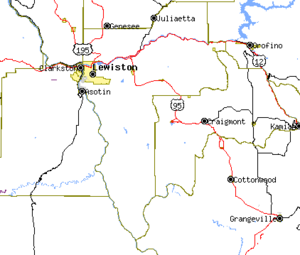
Nez Perce County has two rivers, the Clearwater
and the Snake
, which meet in Lewiston and then flow west. The Clearwater flows from the east and the Snake from the south, creating the state border with Washington (and further upstream, Oregon
). The lowest point in the state of Idaho is located on the Snake River in Lewiston in Nez Perce County, where it flows out of Idaho and into Washington. North of Lewiston, Idaho's western border is a political line.
The northern portion of the county is part of the Palouse
, a wide and rolling agricultural
region of the middle Columbia basin
.
defeated Democrat John Kerry
62% to 36%. In 2008 Republican John McCain
defeated Democrat Barack Obama
by a slightly smaller margin of 58% to 39%.
As of the census
of 2000, there were 37,410 people, 15,286 households, and 10,149 families residing in the county. The population density
was 44 people per square mile (17/km²). There were 16,203 housing units at an average density of 19 per square mile (7/km²). The racial makeup of the county was 91.58% White
, 0.28% Black
or African American
, 5.31% Native American
, 0.65% Asian
, 0.07% Pacific Islander
, 0.50% from other races
, and 1.60% from two or more races. 1.93% of the population were Hispanic
or Latino
of any race. 25.1% were of German, 11.3% English
, 11.0% American
, 8.9% Irish
and 5.6% Norwegian ancestry according to Census 2000.
There were 15,286 households out of which 29.00% had children under the age of 18 living with them, 52.80% were married couples
living together, 9.30% had a female householder with no husband present, and 33.60% were non-families. 26.70% of all households were made up of individuals and 11.30% had someone living alone who was 65 years of age or older. The average household size was 2.40 and the average family size was 2.90.
In the county the population was spread out with 23.80% under the age of 18, 10.00% from 18 to 24, 26.70% from 25 to 44, 23.00% from 45 to 64, and 16.50% who were 65 years of age or older. The median age was 38 years. For every 100 females there were 96.70 males. For every 100 females age 18 and over, there were 93.80 males.
The median income for a household in the county was $36,282, and the median income for a family was $44,212. Males had a median income of $34,688 versus $23,014 for females. The per capita income
for the county was $18,544. About 8.60% of families and 12.20% of the population were below the poverty line, including 15.40% of those under age 18 and 6.70% of those age 65 or over.
County (United States)
In the United States, a county is a geographic subdivision of a state , usually assigned some governmental authority. The term "county" is used in 48 of the 50 states; Louisiana is divided into parishes and Alaska into boroughs. Parishes and boroughs are called "county-equivalents" by the U.S...
located in the U.S. state
U.S. state
A U.S. state is any one of the 50 federated states of the United States of America that share sovereignty with the federal government. Because of this shared sovereignty, an American is a citizen both of the federal entity and of his or her state of domicile. Four states use the official title of...
of Idaho
Idaho
Idaho is a state in the Rocky Mountain area of the United States. The state's largest city and capital is Boise. Residents are called "Idahoans". Idaho was admitted to the Union on July 3, 1890, as the 43rd state....
. The population was 39,265 at the 2010 Census. The county seat
County seat
A county seat is an administrative center, or seat of government, for a county or civil parish. The term is primarily used in the United States....
is Lewiston
Lewiston, Idaho
Lewiston is a city in and also the county seat of Nez Perce County in the Pacific Northwest state of Idaho. It is the second-largest city in the northern Idaho region, behind Coeur d'Alene and ninth-largest in the state. Lewiston is the principal city of the Lewiston, ID - Clarkston, WA...
. The county is named for the Nez Percé tribe.
Nez Perce County was originally organized in 1861, when the area was part of Washington Territory
Washington Territory
The Territory of Washington was an organized incorporated territory of the United States that existed from February 8, 1853, until November 11, 1889, when the final extent of the territory was admitted to the Union as the State of Washington....
. It was reorganized in 1864 by the Idaho Territorial
Idaho Territory
The Territory of Idaho was an organized incorporated territory of the United States that existed from March 4, 1863, until July 3, 1890, when the final extent of the territory was admitted to the Union as the State of Idaho.-1860s:...
Legislature.
Nez Perce County is part of the Lewiston
Lewiston, Idaho
Lewiston is a city in and also the county seat of Nez Perce County in the Pacific Northwest state of Idaho. It is the second-largest city in the northern Idaho region, behind Coeur d'Alene and ninth-largest in the state. Lewiston is the principal city of the Lewiston, ID - Clarkston, WA...
, ID-WA Metropolitan Statistical Area
Lewiston metropolitan area
The Lewiston Metropolitan Statistical Area, as defined by the United States Census Bureau, is an area consisting of two counties – one in the Idaho Panhandle and the other in eastern Washington, anchored by the city of Lewiston...
, which includes the entire county and all of Asotin County, Washington.
Geography
According to the 2000 census, the county has a total area of 856.36 square miles (2,218 km²), of which 849.08 square miles (2,199.1 km²) (or 99.15%) is land and 7.28 square miles (18.9 km²) (or 0.85%) is water.Nez Perce County has two rivers, the Clearwater
Clearwater River (Idaho)
The Clearwater River is a river in north central Idaho, which flows westward from the Bitterroot Mountains along the Idaho-Montana border, and joins the Snake River at Lewiston. In October 1805, the Lewis and Clark Expedition descended the Clearwater River in dugout canoes, putting in at "Canoe...
and the Snake
Snake River
The Snake is a major river of the greater Pacific Northwest in the United States. At long, it is the largest tributary of the Columbia River, the largest North American river that empties into the Pacific Ocean...
, which meet in Lewiston and then flow west. The Clearwater flows from the east and the Snake from the south, creating the state border with Washington (and further upstream, Oregon
Oregon
Oregon is a state in the Pacific Northwest region of the United States. It is located on the Pacific coast, with Washington to the north, California to the south, Nevada on the southeast and Idaho to the east. The Columbia and Snake rivers delineate much of Oregon's northern and eastern...
). The lowest point in the state of Idaho is located on the Snake River in Lewiston in Nez Perce County, where it flows out of Idaho and into Washington. North of Lewiston, Idaho's western border is a political line.
The northern portion of the county is part of the Palouse
Palouse
The Palouse is a region of the northwestern United States, encompassing parts of southeastern Washington, north central Idaho and, in some definitions, extending south into northeast Oregon. It is a major agricultural area, primarily producing wheat and legumes...
, a wide and rolling agricultural
Agriculture
Agriculture is the cultivation of animals, plants, fungi and other life forms for food, fiber, and other products used to sustain life. Agriculture was the key implement in the rise of sedentary human civilization, whereby farming of domesticated species created food surpluses that nurtured the...
region of the middle Columbia basin
Columbia River
The Columbia River is the largest river in the Pacific Northwest region of North America. The river rises in the Rocky Mountains of British Columbia, Canada, flows northwest and then south into the U.S. state of Washington, then turns west to form most of the border between Washington and the state...
.
Adjacent counties
- Latah CountyLatah County, IdahoLatah County is a county located in the north central region of the U.S. state of Idaho. The population was 37,244 at the 2010 census. The county seat and largest city is Moscow, which is the home of the University of Idaho, the state's flagship and land-grant university...
- north - Clearwater CountyClearwater County, IdahoClearwater County is a county located in the U.S. state of Idaho. Established in 1911, the county was named after the Clearwater River. As of the 2000 Census the county had a population of 8,930 . The county seat is Orofino....
- northeast - Lewis CountyLewis County, IdahoLewis County is a county located in the U.S. state of Idaho. Established in 1911, it was named after the explorer Meriwether Lewis. The population was 3,821 at the 2010 census. The county seat is Nezperce, and Kamiah is the county's largest city.-Geography:...
- east - Idaho CountyIdaho County, IdahoIdaho County is a county located in the U.S. state of Idaho. As of the 2010 Census the county had a population of 16,267. The county seat is Grangeville...
- southeast - Wallowa CountyWallowa County, OregonWallowa County is a county located in the U.S. state of Oregon. It is included in the 8 county definition of Eastern Oregon. According to Oregon Geographic Names, the origins of the county's name are uncertain, with the most likely explanation being that it is derived from the Nez Perce term for a...
, OregonOregonOregon is a state in the Pacific Northwest region of the United States. It is located on the Pacific coast, with Washington to the north, California to the south, Nevada on the southeast and Idaho to the east. The Columbia and Snake rivers delineate much of Oregon's northern and eastern...
- southwest - Asotin County, Washington - west
- Whitman County, WashingtonWhitman County, WashingtonWhitman County is a county located in the U.S. state of Washington. As of the 2010 census, the population was 44,776, with the majority living in its largest city, Pullman, home to Washington State University, the state's land-grant university. The county seat is at Colfax.Whitman County was...
- northwest
National protected areas
- Clearwater National ForestClearwater National ForestClearwater National Forest is located in North Central Idaho in the northwestern United States. The forest is bounded on the east by the state of Montana, on the north by the Idaho Panhandle National Forest, and on the south and west by the Nez Perce National Forest and Palouse Prairie.]The forest...
(part) - Nez Perce National Historical ParkNez Perce National Historical ParkThe Nez Perce National Historical Park is a United States National Historical Park comprising 38 sites located throughout the states of Idaho, Montana, Oregon, and Washington which are the traditional aboriginal lands of the Nez Perce. The sites commemorate the history, culture, and stories of the...
(part) - Wallowa–Whitman National Forest (part)
Highways
 - US-12U.S. Route 12 in IdahoUS Route 12 is a state highway in north central Idaho. It extends from the Washington state line in Lewiston east to the Montana state line at Lolo Pass, generally along the route of the Lewis and Clark expedition, and is known as the Northwest Passage Scenic Byway -Route description:US 12 enters...
 - US-95U.S. Route 95 in IdahoIn the U.S. state of Idaho, U.S. Route 95 is a north–south highway near the western border of the state, stretching from Oregon to British Columbia for over .-Route description:...
 - US-195U.S. Route 195U.S. Route 195 is a north–south U.S. Route serving the southeastern area of Washington. One of the oldest designations in the U.S. Highway system, it was created in the original 1926 plan. The highway passes two major universities, Washington State University in Pullman, and the University...
 - SH-3Idaho State Highway 3Idaho State Highway 3 is a state highway in northern Idaho connecting US 12 near Spalding with I-90 near Rose Lake. It is long and runs north–south.-Route description:...
Government and politics
Nez Perce county is a strongly Republican county. In 2004 Republican George W. BushGeorge W. Bush
George Walker Bush is an American politician who served as the 43rd President of the United States, from 2001 to 2009. Before that, he was the 46th Governor of Texas, having served from 1995 to 2000....
defeated Democrat John Kerry
John Kerry
John Forbes Kerry is the senior United States Senator from Massachusetts, the 10th most senior U.S. Senator and chairman of the Senate Foreign Relations Committee. He was the presidential nominee of the Democratic Party in the 2004 presidential election, but lost to former President George W...
62% to 36%. In 2008 Republican John McCain
John McCain
John Sidney McCain III is the senior United States Senator from Arizona. He was the Republican nominee for president in the 2008 United States election....
defeated Democrat Barack Obama
Barack Obama
Barack Hussein Obama II is the 44th and current President of the United States. He is the first African American to hold the office. Obama previously served as a United States Senator from Illinois, from January 2005 until he resigned following his victory in the 2008 presidential election.Born in...
by a slightly smaller margin of 58% to 39%.
Demographics
 |
As of the census
Census
A census is the procedure of systematically acquiring and recording information about the members of a given population. It is a regularly occurring and official count of a particular population. The term is used mostly in connection with national population and housing censuses; other common...
of 2000, there were 37,410 people, 15,286 households, and 10,149 families residing in the county. The population density
Population density
Population density is a measurement of population per unit area or unit volume. It is frequently applied to living organisms, and particularly to humans...
was 44 people per square mile (17/km²). There were 16,203 housing units at an average density of 19 per square mile (7/km²). The racial makeup of the county was 91.58% White
Race (United States Census)
Race and ethnicity in the United States Census, as defined by the Federal Office of Management and Budget and the United States Census Bureau, are self-identification data items in which residents choose the race or races with which they most closely identify, and indicate whether or not they are...
, 0.28% Black
Race (United States Census)
Race and ethnicity in the United States Census, as defined by the Federal Office of Management and Budget and the United States Census Bureau, are self-identification data items in which residents choose the race or races with which they most closely identify, and indicate whether or not they are...
or African American
Race (United States Census)
Race and ethnicity in the United States Census, as defined by the Federal Office of Management and Budget and the United States Census Bureau, are self-identification data items in which residents choose the race or races with which they most closely identify, and indicate whether or not they are...
, 5.31% Native American
Race (United States Census)
Race and ethnicity in the United States Census, as defined by the Federal Office of Management and Budget and the United States Census Bureau, are self-identification data items in which residents choose the race or races with which they most closely identify, and indicate whether or not they are...
, 0.65% Asian
Race (United States Census)
Race and ethnicity in the United States Census, as defined by the Federal Office of Management and Budget and the United States Census Bureau, are self-identification data items in which residents choose the race or races with which they most closely identify, and indicate whether or not they are...
, 0.07% Pacific Islander
Race (United States Census)
Race and ethnicity in the United States Census, as defined by the Federal Office of Management and Budget and the United States Census Bureau, are self-identification data items in which residents choose the race or races with which they most closely identify, and indicate whether or not they are...
, 0.50% from other races
Race (United States Census)
Race and ethnicity in the United States Census, as defined by the Federal Office of Management and Budget and the United States Census Bureau, are self-identification data items in which residents choose the race or races with which they most closely identify, and indicate whether or not they are...
, and 1.60% from two or more races. 1.93% of the population were Hispanic
Race (United States Census)
Race and ethnicity in the United States Census, as defined by the Federal Office of Management and Budget and the United States Census Bureau, are self-identification data items in which residents choose the race or races with which they most closely identify, and indicate whether or not they are...
or Latino
Race (United States Census)
Race and ethnicity in the United States Census, as defined by the Federal Office of Management and Budget and the United States Census Bureau, are self-identification data items in which residents choose the race or races with which they most closely identify, and indicate whether or not they are...
of any race. 25.1% were of German, 11.3% English
English people
The English are a nation and ethnic group native to England, who speak English. The English identity is of early mediaeval origin, when they were known in Old English as the Anglecynn. England is now a country of the United Kingdom, and the majority of English people in England are British Citizens...
, 11.0% American
United States
The United States of America is a federal constitutional republic comprising fifty states and a federal district...
, 8.9% Irish
Irish people
The Irish people are an ethnic group who originate in Ireland, an island in northwestern Europe. Ireland has been populated for around 9,000 years , with the Irish people's earliest ancestors recorded having legends of being descended from groups such as the Nemedians, Fomorians, Fir Bolg, Tuatha...
and 5.6% Norwegian ancestry according to Census 2000.
There were 15,286 households out of which 29.00% had children under the age of 18 living with them, 52.80% were married couples
Marriage
Marriage is a social union or legal contract between people that creates kinship. It is an institution in which interpersonal relationships, usually intimate and sexual, are acknowledged in a variety of ways, depending on the culture or subculture in which it is found...
living together, 9.30% had a female householder with no husband present, and 33.60% were non-families. 26.70% of all households were made up of individuals and 11.30% had someone living alone who was 65 years of age or older. The average household size was 2.40 and the average family size was 2.90.
In the county the population was spread out with 23.80% under the age of 18, 10.00% from 18 to 24, 26.70% from 25 to 44, 23.00% from 45 to 64, and 16.50% who were 65 years of age or older. The median age was 38 years. For every 100 females there were 96.70 males. For every 100 females age 18 and over, there were 93.80 males.
The median income for a household in the county was $36,282, and the median income for a family was $44,212. Males had a median income of $34,688 versus $23,014 for females. The per capita income
Per capita income
Per capita income or income per person is a measure of mean income within an economic aggregate, such as a country or city. It is calculated by taking a measure of all sources of income in the aggregate and dividing it by the total population...
for the county was $18,544. About 8.60% of families and 12.20% of the population were below the poverty line, including 15.40% of those under age 18 and 6.70% of those age 65 or over.
Cities
- CuldesacCuldesac, IdahoCuldesac is a town in Nez Perce County, Idaho, United States. The population was 380 at the 2010 census. It is part of the Lewiston, ID-WA Metropolitan Statistical Area.-Geography:...
- LapwaiLapwai, IdahoLapwai is a city in Nez Perce County, Idaho, United States. The population was 1,137 at the 2010 census. It is the seat of government of the Nez Perce Indian Reservation.Lapwai is part of the Lewiston, ID-WA Metropolitan Statistical Area.-Geography:...
- LewistonLewiston, IdahoLewiston is a city in and also the county seat of Nez Perce County in the Pacific Northwest state of Idaho. It is the second-largest city in the northern Idaho region, behind Coeur d'Alene and ninth-largest in the state. Lewiston is the principal city of the Lewiston, ID - Clarkston, WA...
- PeckPeck, IdahoPeck is a city in Nez Perce County, Idaho, United States. The population was 186 at the 2000 census. It is part of the Lewiston, ID-WA Metropolitan Statistical Area. Many residents of Peck work in nearby Orofino, Idaho...
Unincorporated communities
|
Lenore, Idaho Lenore is an unincorporated community in Nez Perce County, Idaho, United States. Lenore is located on the north bank of the Clearwater River east-northeast of Lewiston. Lenore has a post office with ZIP code 83541.... |
Spalding, Idaho Spalding is an unincorporated village in Nez Percé County, Idaho, United States, ten miles east of Lewiston, on the Clearwater River close to the intersection of U.S. Routes 95 and 12... |
See also
- List of Idaho counties
- National Register of Historic Places listings in Nez Perce County, IdahoNational Register of Historic Places listings in Nez Perce County, IdahoThis is a list of the National Register of Historic Places listings in Nez Perce County, Idaho.This is intended to be a complete list of the properties and districts on the National Register of Historic Places in Nez Perce County, Idaho, United States...