
New Zealand State Highway 4
Encyclopedia
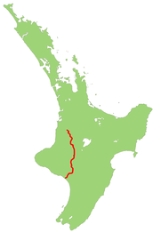
State Highway 4 is the shortest of New Zealand
's eight national highways
. It runs north-south across rugged hill country, forming a short cut between two points on State Highway 3 thereby avoiding Taranaki and the coasts of the North
and South Taranaki Bight
s. Distances are measured from north to south.
For most of its length SH4 is a two-lane single carriageway, with at-grade intersections and property accesses, both in rural and urban areas.
The highway commences from a junction on SH 3 11 km south of Te Kuiti
. It heads south-southeast, climbing initially, then descending along the winding valleys of the Ohura
and Ongarue River
s, two tributaries of the Whanganui
. The Ongarue joins the Whanganui close to Taumarunui
, and here the highway turns east briefly, ascending the Whanganui's valley before turning south to skirt the North Island Volcanic Plateau
. The peaks of the plateau's volcanoes are clearly visible from the highway, especially that of the southernmost, Ruapehu
.
At Horopito
the highway veers southwest briefly, following a tributary of the Maungawhero River until it joins with this river near Raetihi
. The highway continues to descend the Maungawhero's valley to within 40 km of its mouth, then heads west across rolling hill country to the valley of the Whanganui River, which it follows for the last 15 km of its journey into Wanganui
.
New Zealand
New Zealand is an island country in the south-western Pacific Ocean comprising two main landmasses and numerous smaller islands. The country is situated some east of Australia across the Tasman Sea, and roughly south of the Pacific island nations of New Caledonia, Fiji, and Tonga...
's eight national highways
New Zealand State Highway network
The New Zealand State Highway network is the major national highway network in New Zealand. Just under 100 roads in both the North and South Islands are State Highways...
. It runs north-south across rugged hill country, forming a short cut between two points on State Highway 3 thereby avoiding Taranaki and the coasts of the North
North Taranaki Bight
The North Taranaki Bight is the name given to the large bay which extends north and east from the north coast of Taranaki in New Zealand's North Island. The name is echoed by the South Taranaki Bight to the south of Cape Egmont....
and South Taranaki Bight
South Taranaki Bight
The South Taranaki Bight is the name given to the large bay which extends south and east from the south coast of Taranaki in New Zealand's North Island. With more symmetry than poetry or originality, it is matched by the North Taranaki Bight to the north of Cape Egmont.The size of the bight...
s. Distances are measured from north to south.
For most of its length SH4 is a two-lane single carriageway, with at-grade intersections and property accesses, both in rural and urban areas.
Route
This is the route that SH4 takes in 2007.The highway commences from a junction on SH 3 11 km south of Te Kuiti
Te Kuiti
Te Kuiti is a small town in the south of the Waikato region of the North Island of New Zealand. It lies at the junction of State Highways 3 and 30 and on the North Island Main Trunk Railway, 80 km south of Hamilton....
. It heads south-southeast, climbing initially, then descending along the winding valleys of the Ohura
Ohura River
The Ohura River is a river of the western North Island of New Zealand. It flows southward from its source close to the town of Ohura, and flows into the Whanganui River....
and Ongarue River
Ongarue River
The Ongarue River is a river of the Waikato and Manawatu-Wanganui Regions of New Zealand's North Island. A major tributary of the Whanganui River, it flows west then south from its sources in the Hauhungaroa Range northwest of Lake Taupo, passing through the town of Taumarunui before reaching the...
s, two tributaries of the Whanganui
Whanganui River
The Whanganui River is a major river in the North Island of New Zealand.Known for many years as the Wanganui River, the river's name reverted to Whanganui in 1991, according with the wishes of local iwi. Part of the reason was also to avoid confusion with the Wanganui River in the South Island...
. The Ongarue joins the Whanganui close to Taumarunui
Taumarunui
Taumarunui is a town in the King Country of the central North Island of New Zealand. It is on State Highway 4 and the North Island Main Trunk Railway....
, and here the highway turns east briefly, ascending the Whanganui's valley before turning south to skirt the North Island Volcanic Plateau
North Island Volcanic Plateau
The North Island Volcanic Plateau is a volcanic plateau covering much of central North Island of New Zealand with volcanoes, lava plateaus, and crater lakes....
. The peaks of the plateau's volcanoes are clearly visible from the highway, especially that of the southernmost, Ruapehu
Mount Ruapehu
Mount Ruapehu, or just Ruapehu, is an active stratovolcano at the southern end of the Taupo Volcanic Zone in New Zealand. It is 23 kilometres northeast of Ohakune and 40 kilometres southwest of the southern shore of Lake Taupo, within Tongariro National Park...
.
At Horopito
Horopito
Horopito may refer to:*Horopito, the name of two plant species in the Pseudowintera genus in the Māori language*Horopito, New Zealand, a location in the North Island of New Zealand...
the highway veers southwest briefly, following a tributary of the Maungawhero River until it joins with this river near Raetihi
Raetihi
Raetihi is a town in the central North Island of New Zealand. It is located at the junction of State Highways 4 and 49, 11 kilometres west of Ohakune. The 2006 New Zealand Census of Population and Dwellings recorded its population as 1,035. This constitutes a decrease of 3.4% or 36 people since...
. The highway continues to descend the Maungawhero's valley to within 40 km of its mouth, then heads west across rolling hill country to the valley of the Whanganui River, which it follows for the last 15 km of its journey into Wanganui
Wanganui
Whanganui , also spelled Wanganui, is an urban area and district on the west coast of the North Island of New Zealand. It is part of the Manawatu-Wanganui region....
.
Major Junctions
| Territorial authority | Location | km | Destinations | Notes |
|---|---|---|---|---|
| Waitomo District Waitomo District Waitomo District is a territorial authority in the north of the King Country region in the North Island of New Zealand. A small part of the district, the town of Tiroa, however, lies in the Manawatu-Wanganui region.... |
Eight Mile Junction | 0 |  SH 3 SH 3New Zealand State Highway 3 State Highway 3 is one of New Zealand's eight national highways. It serves the west coast of the country's North Island and forms a link between State Highway 1 and State Highway 2... north Hamilton Hamilton, New Zealand Hamilton is the centre of New Zealand's fourth largest urban area, and Hamilton City is the country's fourth largest territorial authority. Hamilton is in the Waikato Region of the North Island, approximately south of Auckland... |
SH 4 begins |
| SH 3 New Zealand State Highway 3 State Highway 3 is one of New Zealand's eight national highways. It serves the west coast of the country's North Island and forms a link between State Highway 1 and State Highway 2... south New Plymouth New Plymouth New Plymouth is the major city of the Taranaki Region on the west coast of the North Island of New Zealand. It is named after Plymouth, Devon, England, from where the first English settlers migrated.... |
||||
| Ruapehu District Ruapehu District Ruapehu District is a territorial authority near the centre of New Zealand's North Island.It has an area of 6,730.185 square kilometers and a population of 13,569 at the 2006 census .-Features:... |
Taumarunui Taumarunui Taumarunui is a town in the King Country of the central North Island of New Zealand. It is on State Highway 4 and the North Island Main Trunk Railway.... |
70 |  SH 43 SH 43New Zealand State Highway 43 New Zealand State Highway 43, also called the Forgotten World Highway, is a road that runs 158 km from Stratford, New Zealand in Taranaki to Taumarunui in the King Country... (Kururau Road) Stratford Stratford, New Zealand Stratford is the only town in the central Taranaki district of Stratford District, New Zealand. It lies beneath the eastern slopes of Mount Taranaki/Egmont, approximately half-way between New Plymouth and Hawera, near the geographic centre of the Taranaki region. The town has a population of... |
|
| Whanganui River Whanganui River The Whanganui River is a major river in the North Island of New Zealand.Known for many years as the Wanganui River, the river's name reverted to Whanganui in 1991, according with the wishes of local iwi. Part of the reason was also to avoid confusion with the Wanganui River in the South Island... |
||||
| Manunui Manunui Manunui is a small settlement in the North Island of New Zealand. It is located in the King Country region, about 4 km east of Taumarunui. Manunui is where State Highway 41 to Lake Taupo branches off from State Highway 4... |
77 |  SH 41 SH 41 Turangi Turangi Turangi is a small town on the west bank of the Tongariro River, 50 kilometres south-west of Taupo on the North Island Volcanic Plateau of New Zealand. It was built to accommodate the workers associated with the Tongariro hydro-electric power development project and their families... |
||
| National Park National Park, New Zealand National Park is a small town on the central plateau of the North Island of New Zealand. Also known as National Park Village it is the highest urban township in New Zealand at 825 metres. As the name suggests, it borders the World Heritage Tongariro National Park, New Zealand's first national... |
114 |  SH 47 SH 47 Turangi Turangi Turangi is a small town on the west bank of the Tongariro River, 50 kilometres south-west of Taupo on the North Island Volcanic Plateau of New Zealand. It was built to accommodate the workers associated with the Tongariro hydro-electric power development project and their families... |
||
| Tohunga Junction | 140 |  SH 49 SH 49New Zealand State Highway 49 State Highway 49 is a New Zealand State Highway, linking State Highway 4 and State Highway 1, via the tourist town of Ohakune. It forms the southern part of the ring road surrounding Tongariro National Park, and provides access to the southern side of Mount Ruapehu and the Turoa skifield.State... Ohakune Ohakune Ohakune is a town in the North Island of New Zealand. It is located at the southern end of the Tongariro National Park, close to the southwestern slopes of the active volcano Mount Ruapehu. Part of the Manawatu-Wanganui region, the town is 70 kilometres northeast of Wanganui, and 25 kilometres west... , Waiouru Waiouru Waiouru is a small town in the centre of the North Island of New Zealand. It is on the North Island Volcanic Plateau, 25 kilometres south-east of Mount Ruapehu, and in the Ruapehu District.... |
||
| Wanganui District Wanganui Whanganui , also spelled Wanganui, is an urban area and district on the west coast of the North Island of New Zealand. It is part of the Manawatu-Wanganui region.... |
Putiki | 237 | SH 3 New Zealand State Highway 3 State Highway 3 is one of New Zealand's eight national highways. It serves the west coast of the country's North Island and forms a link between State Highway 1 and State Highway 2... north Wanganui Wanganui Whanganui , also spelled Wanganui, is an urban area and district on the west coast of the North Island of New Zealand. It is part of the Manawatu-Wanganui region.... , New Plymouth New Plymouth New Plymouth is the major city of the Taranaki Region on the west coast of the North Island of New Zealand. It is named after Plymouth, Devon, England, from where the first English settlers migrated.... |
SH 4 ends |
| SH 3 New Zealand State Highway 3 State Highway 3 is one of New Zealand's eight national highways. It serves the west coast of the country's North Island and forms a link between State Highway 1 and State Highway 2... south Palmerston North Palmerston North Palmerston North is the main city of the Manawatu-Wanganui region of the North Island of New Zealand. It is an inland city with a population of and is the country's seventh largest city and eighth largest urban area. Palmerston North is located in the eastern Manawatu Plains near the north bank... |
See also
- List of New Zealand State Highways
- List of roads and highways, for notable or famous roads worldwide