
New Zealand State Highway 49
Encyclopedia
State Highway 49 is a New Zealand
State Highway
, linking State Highway 4
and State Highway 1, via the tourist town of Ohakune
. It forms the southern part of the ring road surrounding Tongariro National Park
, and provides access to the southern side of Mount Ruapehu
and the Turoa skifield
.
State Highway 49, along with State Highways 4, 47, and 46, is used as an alternative route to State Highway 1's Desert Road, and is well used when the Desert Road is closed due to snow.
State Highway 49 lies entirely within the Ruapehu District
.

 State Highway 49 runs northwest to southeast, and roughly follows the North Island Main Trunk railway. This is the route SH 49 takes in 2008.
State Highway 49 leaves SH 4 at Tohunga Junction, some eight kilometres north of Raetihi
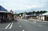
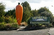
, and heads southeast across rolling hills to the tourist town of Ohakune. Following Ohakune's main street, the road continues southeast out of the township, passing Ohakune's famous giant carrot.
State Highway 49 continues southeast across rolling hills, running broadly in the same direction as the North Island Main Trunk. It passes the rural villages of Rangataua and Karioi, before meeting the railway line at the Whangaehu River
at Tangiwai. The bridge here has flashing lighs and gates to block off the road in case of a lahar
from Mount Ruapehu
's crater lake
. To the side of the bridge is the Tangiwai memorial, erected to remember the 151 people who died when a Wellington
to Auckland
express train plunged into the river following a lahar on 24 December 1953.
After crossing the Whangaehu River, and the railway line, SH 49 turns east for several kilometres, before turning south into Waiouru
. At Waiouru, SH 49 ends at the intersection with State Highway 1.
, where it terminated at State Highway 4. SH 49A has since been revoked.
New Zealand
New Zealand is an island country in the south-western Pacific Ocean comprising two main landmasses and numerous smaller islands. The country is situated some east of Australia across the Tasman Sea, and roughly south of the Pacific island nations of New Caledonia, Fiji, and Tonga...
State Highway
New Zealand State Highway network
The New Zealand State Highway network is the major national highway network in New Zealand. Just under 100 roads in both the North and South Islands are State Highways...
, linking State Highway 4
New Zealand State Highway 4
State Highway 4 is the shortest of New Zealand's eight national highways. It runs north-south across rugged hill country, forming a short cut between two points on State Highway 3 thereby avoiding Taranaki and the coasts of the North and South Taranaki Bights...
and State Highway 1, via the tourist town of Ohakune
Ohakune
Ohakune is a town in the North Island of New Zealand. It is located at the southern end of the Tongariro National Park, close to the southwestern slopes of the active volcano Mount Ruapehu. Part of the Manawatu-Wanganui region, the town is 70 kilometres northeast of Wanganui, and 25 kilometres west...
. It forms the southern part of the ring road surrounding Tongariro National Park
Tongariro National Park
Tongariro National Park is the oldest national park in New Zealand, located in the central North Island. It has been acknowledged by UNESCO as one of the 28 mixed cultural and natural World Heritage Sites....
, and provides access to the southern side of Mount Ruapehu
Mount Ruapehu
Mount Ruapehu, or just Ruapehu, is an active stratovolcano at the southern end of the Taupo Volcanic Zone in New Zealand. It is 23 kilometres northeast of Ohakune and 40 kilometres southwest of the southern shore of Lake Taupo, within Tongariro National Park...
and the Turoa skifield
Turoa
Turoa is a large skifield on the south western side of Mount Ruapehu, the highest mountain in the North Island of New Zealand, in Tongariro National Park. The area has been used for skiing since before the completion of the Mountain Road, but the first lifts opened in 1978.There are two beginner...
.
State Highway 49, along with State Highways 4, 47, and 46, is used as an alternative route to State Highway 1's Desert Road, and is well used when the Desert Road is closed due to snow.
State Highway 49 lies entirely within the Ruapehu District
Ruapehu District
Ruapehu District is a territorial authority near the centre of New Zealand's North Island.It has an area of 6,730.185 square kilometers and a population of 13,569 at the 2006 census .-Features:...
.
Route
State Highway 49 leaves SH 4 at Tohunga Junction, some eight kilometres north of Raetihi
Raetihi
Raetihi is a town in the central North Island of New Zealand. It is located at the junction of State Highways 4 and 49, 11 kilometres west of Ohakune. The 2006 New Zealand Census of Population and Dwellings recorded its population as 1,035. This constitutes a decrease of 3.4% or 36 people since...
, and heads southeast across rolling hills to the tourist town of Ohakune. Following Ohakune's main street, the road continues southeast out of the township, passing Ohakune's famous giant carrot.
State Highway 49 continues southeast across rolling hills, running broadly in the same direction as the North Island Main Trunk. It passes the rural villages of Rangataua and Karioi, before meeting the railway line at the Whangaehu River
Whangaehu River
The Whangaehu River is a large river in central North Island of New Zealand. Its headwaters are the crater lake of Mount Ruapehu on the central plateau, and it flows into the Tasman Sea eight kilometres southeast of Wanganui.-Length:...
at Tangiwai. The bridge here has flashing lighs and gates to block off the road in case of a lahar
Lahar
A lahar is a type of mudflow or debris flow composed of a slurry of pyroclastic material, rocky debris, and water. The material flows down from a volcano, typically along a river valley. The term is a shortened version of "berlahar" which originated in the Javanese language of...
from Mount Ruapehu
Mount Ruapehu
Mount Ruapehu, or just Ruapehu, is an active stratovolcano at the southern end of the Taupo Volcanic Zone in New Zealand. It is 23 kilometres northeast of Ohakune and 40 kilometres southwest of the southern shore of Lake Taupo, within Tongariro National Park...
's crater lake
Crater lake
A crater lake is a lake that forms in a volcanic crater or caldera, such as a maar; less commonly and with lower association to the term a lake may form in an impact crater caused by a meteorite. Sometimes lakes which form inside calderas are called caldera lakes, but often this distinction is not...
. To the side of the bridge is the Tangiwai memorial, erected to remember the 151 people who died when a Wellington
Wellington
Wellington is the capital city and third most populous urban area of New Zealand, although it is likely to have surpassed Christchurch due to the exodus following the Canterbury Earthquake. It is at the southwestern tip of the North Island, between Cook Strait and the Rimutaka Range...
to Auckland
Auckland
The Auckland metropolitan area , in the North Island of New Zealand, is the largest and most populous urban area in the country with residents, percent of the country's population. Auckland also has the largest Polynesian population of any city in the world...
express train plunged into the river following a lahar on 24 December 1953.
After crossing the Whangaehu River, and the railway line, SH 49 turns east for several kilometres, before turning south into Waiouru
Waiouru
Waiouru is a small town in the centre of the North Island of New Zealand. It is on the North Island Volcanic Plateau, 25 kilometres south-east of Mount Ruapehu, and in the Ruapehu District....
. At Waiouru, SH 49 ends at the intersection with State Highway 1.
History
State Highway 49 used to have one spur - State Highway 49A. It separated from SH 49 at Ohakune, and ran east to RaetihiRaetihi
Raetihi is a town in the central North Island of New Zealand. It is located at the junction of State Highways 4 and 49, 11 kilometres west of Ohakune. The 2006 New Zealand Census of Population and Dwellings recorded its population as 1,035. This constitutes a decrease of 3.4% or 36 people since...
, where it terminated at State Highway 4. SH 49A has since been revoked.
Major intersections
| Territorial authority | Location | km | Destinations | Notes |
|---|---|---|---|---|
| Ruapehu District Ruapehu District Ruapehu District is a territorial authority near the centre of New Zealand's North Island.It has an area of 6,730.185 square kilometers and a population of 13,569 at the 2006 census .-Features:... |
Tohunga Junction | 0 |  SH 4 SH 4New Zealand State Highway 4 State Highway 4 is the shortest of New Zealand's eight national highways. It runs north-south across rugged hill country, forming a short cut between two points on State Highway 3 thereby avoiding Taranaki and the coasts of the North and South Taranaki Bights... north National Park National Park, New Zealand National Park is a small town on the central plateau of the North Island of New Zealand. Also known as National Park Village it is the highest urban township in New Zealand at 825 metres. As the name suggests, it borders the World Heritage Tongariro National Park, New Zealand's first national... |
SH 49 begins |
| SH 4 New Zealand State Highway 4 State Highway 4 is the shortest of New Zealand's eight national highways. It runs north-south across rugged hill country, forming a short cut between two points on State Highway 3 thereby avoiding Taranaki and the coasts of the North and South Taranaki Bights... south Wanganui Wanganui Whanganui , also spelled Wanganui, is an urban area and district on the west coast of the North Island of New Zealand. It is part of the Manawatu-Wanganui region.... |
||||
| Ohakune Ohakune Ohakune is a town in the North Island of New Zealand. It is located at the southern end of the Tongariro National Park, close to the southwestern slopes of the active volcano Mount Ruapehu. Part of the Manawatu-Wanganui region, the town is 70 kilometres northeast of Wanganui, and 25 kilometres west... |
(Goldfinch Street) Turoa skifield Turoa Turoa is a large skifield on the south western side of Mount Ruapehu, the highest mountain in the North Island of New Zealand, in Tongariro National Park. The area has been used for skiing since before the completion of the Mountain Road, but the first lifts opened in 1978.There are two beginner... |
|||
| (Raehiti Ohakune Road) Raetihi Raetihi Raetihi is a town in the central North Island of New Zealand. It is located at the junction of State Highways 4 and 49, 11 kilometres west of Ohakune. The 2006 New Zealand Census of Population and Dwellings recorded its population as 1,035. This constitutes a decrease of 3.4% or 36 people since... |
Former SH 49A junction | |||
| Tangiwai | Whangaehu River Whangaehu River The Whangaehu River is a large river in central North Island of New Zealand. Its headwaters are the crater lake of Mount Ruapehu on the central plateau, and it flows into the Tasman Sea eight kilometres southeast of Wanganui.-Length:... |
|||
| Waiouru Waiouru Waiouru is a small town in the centre of the North Island of New Zealand. It is on the North Island Volcanic Plateau, 25 kilometres south-east of Mount Ruapehu, and in the Ruapehu District.... |
36 |  SH 1 north SH 1 north (Desert Road) Taupo Taupo Taupo is a town on the shore of Lake Taupo in the centre of the North Island of New Zealand. It is the seat of the Taupo District Council and lies in the southern Waikato Region.... |
SH 49 ends | |
| SH 1 south Palmerston North Palmerston North Palmerston North is the main city of the Manawatu-Wanganui region of the North Island of New Zealand. It is an inland city with a population of and is the country's seventh largest city and eighth largest urban area. Palmerston North is located in the eastern Manawatu Plains near the north bank... |
||||