
New York State Route 37
Encyclopedia
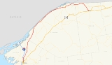
New York State Route 37 (NY 37) is a state highway
in the North Country
of New York
in the United States, extending for 127.4 miles (205.03 km) on a west–east axis. The western terminus of the route is at an intersection with U.S. Route 11
(US 11) in Watertown
, Jefferson County
. Its eastern terminus is at a junction with US 11, NY 11B
, and NY 30
in Malone
, Franklin County
. In between the termini, NY 37 passes through Ogdensburg
and Massena
. It is a two-lane, nondivided, full access roadway for most of its entire length, except for portions between Massena and western Franklin County, where the route widens to a four-lane divided highway
.
NY 37 was assigned in 1930 to the portion of the Theodore Roosevelt International Highway
between Redwood
and Malone as well as to a previously unnumbered roadway between Watertown and Redwood. The Redwood–Malone portion was originally part of NY 3
when the first set of posted routes in New York were assigned in 1924. NY 37 has since been rerouted in areas, primarily near Ogdensburg and Massena.
just north of Watertown. Between Watertown and Theresa
, NY 37 follows a north–south alignment and parallels Interstate 81
(I-81), located just west of NY 37. Southwest of Theresa, I-81 turns to the northwest as NY 37 intersects NY 26
and NY 411
, the westward continuation of NY 26. NY 26 joins NY 37 around the western edge of the village before splitting to the northwest a short distance to the north. NY 37, however, continues northward, passing through Redwood
before curving northeast as it enters St. Lawrence County
.
Across the county line, NY 37 parallels NY 12
to the north as both routes proceed northeast. Roughly 7 miles (11 km) from the county line, NY 37 encounters Hammond
, a small village located west of Black Lake
. Past Hammond, Route 37 heads north toward Morristown
, where it meets NY 12, the primary roadway along the St. Lawrence River's southern bank west of this point. NY 12 ends here; however, NY 37 takes over the routing of NY 12 and proceeds northeast along the edge of the St. Lawrence River. Just east of NY 12, NY 37 meets the northernmost point of NY 58
.
Midway between Morristown and Ogdensburg
, NY 37 enters St. Lawrence State Park, one of many New York
state parks located on the southern bank of the river. The route exits the park and heads northeast to Ogdensburg, where it meets NY 68
(the former routing of NY 37 into Ogdensburg) west of the city. While NY 68 continues into downtown, NY 37 turns eastward, then northeastward and bypasses the city to the south. Near the Ogdensburg International Airport
, NY 37 meets NY 812
at an interchange. Here, NY 812 joins NY 37 and the two routes intersect NY 68 once more before leaving Ogdensburg.
over the Ogdensburg–Prescott International Bridge, where it becomes Highway 16 farther inland. NY 37, however, continues to follow the south bank of the St. Lawrence River, passing Galop Island State Park on its way to Waddington
, where it intersects the northernmost point on NY 345
. East of the village, NY 37 passes south of the riverside Coles Creek State Park
and traverses Coles Creek itself.
In the Louisville
hamlet of Louisville Corner (west of Massena
), NY 37 departs the St. Lawrence River and intersects the western end of NY 131
, a northerly bypass of Massena along the riverbank. Farther east in Massena, NY 37 intersects NY 37B
, the former routing of NY 37 through Massena, west of the village before crossing over the Grasse River
and intersecting the northern termini of both NY 56
(where NY 37 widens into a four-lane divided highway
) and NY 420
. NY 37B later rejoins NY 37 east of the village, as does NY 131 directly north of the Massena International Airport
.
 East of the airport in the town of Massena
, NY 37 begins to parallel the north bank of the Raquette River
as it intersects NY 37C near a hamlet named for the waterway. NY 37 and the river continue northeast to the vicinity of the hamlet of Rooseveltown, where NY 37 connects to a large traffic circle
linking NY 37 to the Three Nations Crossing as well as County Route 45 (CR 45). Upon crossing into Franklin County
and the St. Regis Mohawk Reservation a short distance to the east, the road narrows back to a two-lane undivided highway and crosses over the Raquette River.
Although most of NY 37 in the town of Bombay
is contained within the reservation, a short portion east of Hogansburg
and the St. Regis River
and west of Tarbell Road is located outside the reservation limits. Within this stretch, NY 37 meets both the eastern end of NY 37C and the northern terminus of NY 95
. East of the reservation, NY 37 roughly parallels the CSX Transportation
-owned Montreal Subdivision
northeast to Fort Covington
, where NY 37 crosses the railroad line and intersects Water Street (unsigned NY 970T), a connector to Quebec Route 132 on the northern side of the Canadian border.
East of Fort Covington, NY 37 follows a more southeasterly routing as it separates from the northernmost extents of the state. In the Westville
hamlet of Westville Center, NY 37 meets the western terminus of NY 122
. Farther south, NY 37 enters the village of Malone
, where it terminates at US 11
, NY 11B
and NY 30
.
to Malone
was originally part of the Theodore Roosevelt International Highway
, an international auto trail
connecting Portland, Maine
, on the Atlantic Ocean
coast to Portland, Oregon
, east of the Pacific Ocean
. When the first set of posted routes in New York
were assigned in 1924, the entirety of the Roosevelt Highway in New York was designated NY 3
. In the 1930 renumbering of state highways in New York, NY 3 was rerouted to follow its current routing between Watertown and Plattsburgh. The former routing of NY 3 along the St. Lawrence River became part of the new NY 37, which utilized a previously unnumbered highway between Watertown and Redwood via Theresa
. Initially, NY 37 directly served Theresa by way of modern CR 136, CR 46, and CR 193; however, it was realigned ca. 1934 to bypass the village to the west.
When NY 37 was first assigned, it entered Ogdensburg
on Main Street (modern NY 68
) and exited the city on Ford Street and Proctor Avenue. East of the city, NY 37 used less than 1 miles (1.6 km) of its modern alignment before turning south to follow Van Rensselaer Road to Waddington
. The modern, riverside alignment of NY 37 between Ogdensburg and Waddington was designated as NY 37A as part of the 1930 renumbering. In the late 1950s, the alignments of NY 37 and NY 37A were flipped, placing NY 37 on its current routing and NY 37A on Van Rensselaer Road. During the same time period, NY 37 was rerouted to follow a new bypass around the southern edge of Ogdensburg.
In the Massena
area, NY 37 originally broke from its modern alignment west of the village and followed what is now NY 37B
east to Main Street. Here, it turned south onto Main Street to traverse the Grasse River
before continuing east on Orvis Street (and meeting modern NY 37B at Center Street) to reconnect to its current alignment east of the village. Lastly, from modern NY 131
adjacent to the Massena International Airport
to Rooseveltown
, NY 37 was initially routed on Trippany Road, NY 37C, and Roosevelt Road. In the mid-1950s, construction began on a new southern bypass of Massena that connected to NY 37 at the modern termini of NY 37B. It was completed and opened to traffic by 1958. Work on an eastward, divided highway
extension of the bypass to Rooseveltown began ca. 1961. The final section, from the hamlet of Raquette River to Rooseveltown, opened to traffic later that year.
 NY 37 once had as many as four suffixed routes; two have since been removed.
State highway
State highway, state road or state route can refer to one of three related concepts, two of them related to a state or provincial government in a country that is divided into states or provinces :#A...
in the North Country
North Country, New York
The North Country is a region of the U.S. state of New York that encompasses the state's extreme northern frontier, bordering Lake Ontario on the west, the Saint Lawrence River and the Canadian provinces of Ontario and Quebec on the north and northwest, and Lake Champlain and Vermont on the east...
of New York
New York
New York is a state in the Northeastern region of the United States. It is the nation's third most populous state. New York is bordered by New Jersey and Pennsylvania to the south, and by Connecticut, Massachusetts and Vermont to the east...
in the United States, extending for 127.4 miles (205.03 km) on a west–east axis. The western terminus of the route is at an intersection with U.S. Route 11
U.S. Route 11 in New York
U.S. Route 11 is a part of the U.S. Highway System that runs from New Orleans, Louisiana, to the Canadian border at Rouses Point, New York...
(US 11) in Watertown
Watertown (city), New York
Watertown is a city in the state of New York and the county seat of Jefferson County. It is situated approximately south of the Thousand Islands. As of the 2010 census, it had a population of 27,023, an increase of 1.2% since 2000. The U.S...
, Jefferson County
Jefferson County, New York
Jefferson County is a county located in the U.S. state of New York. As of the 2010 census, the population was 116,229. It is named after Thomas Jefferson, third President of the United States of America, and president at the time the county was created in 1805...
. Its eastern terminus is at a junction with US 11, NY 11B
New York State Route 11B
New York State Route 11B is a state highway in northern New York, United States. It provides a parallel, more southerly east–west route to U.S. Route 11 between US 11 in Potsdam and US 11, NY 30, and NY 37 in Malone...
, and NY 30
New York State Route 30
New York State Route 30 is a state highway in the central part of New York in the United States. It extends for from an interchange with NY 17 in the Southern Tier to the Canadian border in the state's North Country, where it continues into Quebec as Route 138. On a regional level,...
in Malone
Malone (village), New York
-Notable natives:Notable natives include:*William Almon Wheeler served as Vice President of the United States under Rutherford Hayes. Is buried at Morningside Cemetery in Malone....
, Franklin County
Franklin County, New York
Franklin County is a county located in the U.S. state of New York. As of the 2010 census, the population was 51,599. It is named in honor of American Founding Father Benjamin Franklin...
. In between the termini, NY 37 passes through Ogdensburg
Ogdensburg, New York
Ogdensburg is a city in St. Lawrence County, New York, United States. The population was 11,128 at the 2010 census. In the late 18th century, European-American settlers named the community after American land owner and developer Samuel Ogden....
and Massena
Massena (village), New York
Massena is a village in St. Lawrence County, New York, United States. The population was 13,589 at the 2000 census. The village is named after Andre Massena, one of Napoleon's generals....
. It is a two-lane, nondivided, full access roadway for most of its entire length, except for portions between Massena and western Franklin County, where the route widens to a four-lane divided highway
Divided Highway
Divided Highway is a compilation album by American rock band The Doobie Brothers, released in 2003. . All tracks are taken from the albums Cycles and Brotherhood .-Track listing:...
.
NY 37 was assigned in 1930 to the portion of the Theodore Roosevelt International Highway
Theodore Roosevelt International Highway
The Theodore Roosevelt International Highway was a transcontinental North American highway through the United States and Canada that ran from Portland, Maine, to Portland, Oregon. Its length was about .-Route description:...
between Redwood
Redwood, New York
Redwood is a census-designated place in Jefferson County, New York, United States. As of the 2000 census, the area population was 584.Redwood is in the eastern part of the Town of Alexandria The community is near the southeast town line.-Geography:...
and Malone as well as to a previously unnumbered roadway between Watertown and Redwood. The Redwood–Malone portion was originally part of NY 3
New York State Route 3
New York State Route 3 is a major east–west state highway in New York, United States, that connects central New York to the North Country region near the Canadian border via Adirondack Park. The route extends for between its western terminus at an intersection with NY 104A in the Cayuga...
when the first set of posted routes in New York were assigned in 1924. NY 37 has since been rerouted in areas, primarily near Ogdensburg and Massena.
Watertown to Ogdensburg
NY 37 begins at an intersection with US 11U.S. Route 11 in New York
U.S. Route 11 is a part of the U.S. Highway System that runs from New Orleans, Louisiana, to the Canadian border at Rouses Point, New York...
just north of Watertown. Between Watertown and Theresa
Theresa (village), New York
Theresa is a village located in the Town of Theresa in Jefferson County, New York, USA. The population was 812 at the 2000 census.The Village of Theresa is northeast of Watertown.- History :...
, NY 37 follows a north–south alignment and parallels Interstate 81
Interstate 81 in New York
Interstate 81 is a part of the Interstate Highway System that runs from Dandridge, Tennessee, to the Canada – United States border at Wellesley Island in New York. In the U.S. state of New York, I-81 extends from the Pennsylvania state line southeast of Binghamton to the Canadian border...
(I-81), located just west of NY 37. Southwest of Theresa, I-81 turns to the northwest as NY 37 intersects NY 26
New York State Route 26
New York State Route 26 is a north–south state highway that runs for through Central New York in the United States. Its southern terminus is located at the Pennsylvania state line south of the town of Vestal in Broome County, where it becomes Pennsylvania Route 267...
and NY 411
New York State Route 411
New York State Route 411 is an east–west state highway in Jefferson County, New York, United States. The western terminus of the route is at an intersection with NY 180 in the community of La Fargeville in the town of Orleans...
, the westward continuation of NY 26. NY 26 joins NY 37 around the western edge of the village before splitting to the northwest a short distance to the north. NY 37, however, continues northward, passing through Redwood
Redwood, New York
Redwood is a census-designated place in Jefferson County, New York, United States. As of the 2000 census, the area population was 584.Redwood is in the eastern part of the Town of Alexandria The community is near the southeast town line.-Geography:...
before curving northeast as it enters St. Lawrence County
St. Lawrence County, New York
St. Lawrence County is a county located in the U.S. state of New York. As of the 2010 census, the population was 111,944. The county seat is Canton. The county is named for the Saint Lawrence River, which in turn was named for the Catholic saint on whose Feast day the river was discovered by...
.
Across the county line, NY 37 parallels NY 12
New York State Route 12
New York State Route 12 is a state highway extending for through central and northern New York in the United States. The southern terminus of the route is at U.S. Route 11 in the town of Chenango in the Southern Tier. The northern terminus is at NY 37 near the village of...
to the north as both routes proceed northeast. Roughly 7 miles (11 km) from the county line, NY 37 encounters Hammond
Hammond (village), New York
Hammond is a village in St. Lawrence County, New York, United States. The population was 302 at the 2000 census. The village is named after an early landowner....
, a small village located west of Black Lake
Black Lake (New York)
Black Lake is a lake in the northern part of New York in the United States and is the largest lake in Saint Lawrence County. The lake is south of the Saint Lawrence River and parallels the river for many miles....
. Past Hammond, Route 37 heads north toward Morristown
Morristown (village), New York
Morristown is a village along the Saint Lawrence River in St. Lawrence County, New York, United States. The population was 456 at the 2000 census...
, where it meets NY 12, the primary roadway along the St. Lawrence River's southern bank west of this point. NY 12 ends here; however, NY 37 takes over the routing of NY 12 and proceeds northeast along the edge of the St. Lawrence River. Just east of NY 12, NY 37 meets the northernmost point of NY 58
New York State Route 58
New York State Route 58 is a north–south state highway located in St. Lawrence County, New York, United States. The highway runs in a northwest to southeast direction as it traverses the county. The southern terminus of the route is at a junction with NY 3 in the hamlet of Fine within...
.
Midway between Morristown and Ogdensburg
Ogdensburg, New York
Ogdensburg is a city in St. Lawrence County, New York, United States. The population was 11,128 at the 2010 census. In the late 18th century, European-American settlers named the community after American land owner and developer Samuel Ogden....
, NY 37 enters St. Lawrence State Park, one of many New York
New York
New York is a state in the Northeastern region of the United States. It is the nation's third most populous state. New York is bordered by New Jersey and Pennsylvania to the south, and by Connecticut, Massachusetts and Vermont to the east...
state parks located on the southern bank of the river. The route exits the park and heads northeast to Ogdensburg, where it meets NY 68
New York State Route 68
New York State Route 68 is an east–west state highway located entirely within St. Lawrence County in the North Country of New York in the United States. The western terminus is at an intersection with NY 37 in Oswegatchie, just west of the Ogdensburg city limits...
(the former routing of NY 37 into Ogdensburg) west of the city. While NY 68 continues into downtown, NY 37 turns eastward, then northeastward and bypasses the city to the south. Near the Ogdensburg International Airport
Ogdensburg International Airport
Ogdensburg International Airport is a public airport located two miles southeast of the central business district of Ogdensburg, a city in St. Lawrence County, New York, United States. It is owned by the Ogdensburg Bridge & Port Authority. and is situated just outside the city limits on NYS Route...
, NY 37 meets NY 812
New York State Route 812
New York State Route 812 is a state highway in the North Country of New York in the United States. The southern terminus of the route is at an intersection with NY 12 and NY 26 in the Lewis County village of Lowville...
at an interchange. Here, NY 812 joins NY 37 and the two routes intersect NY 68 once more before leaving Ogdensburg.
Ogdensburg to Massena
Just outside of Ogdensburg, NY 812 separates from NY 37 to continue northward to CanadaCanada
Canada is a North American country consisting of ten provinces and three territories. Located in the northern part of the continent, it extends from the Atlantic Ocean in the east to the Pacific Ocean in the west, and northward into the Arctic Ocean...
over the Ogdensburg–Prescott International Bridge, where it becomes Highway 16 farther inland. NY 37, however, continues to follow the south bank of the St. Lawrence River, passing Galop Island State Park on its way to Waddington
Waddington (village), New York
Waddington is a village located in the Town of Waddington in St. Lawrence County, New York. The population was 923 at the 2000 census. The village is named after Joshua Waddington....
, where it intersects the northernmost point on NY 345
New York State Route 345
New York State Route 345 is a state highway located entirely within St. Lawrence County in the North Country of New York in the United States. It is a north–south route connecting the towns of Waddington and Potsdam by way of the town of Madrid. The southern terminus of NY 345 is at an...
. East of the village, NY 37 passes south of the riverside Coles Creek State Park
Coles Creek State Park
Coles Creek State Park is located on the St. Lawrence River on the west bank of Coles Creek. This state park is in the Town of Waddington in St...
and traverses Coles Creek itself.
In the Louisville
Louisville, New York
Louisville is a town in St. Lawrence County, New York, United States. The population was 3,195 at the 2000 census. The town is reportedly named after a French king, but it is pronounced as "Lewis-ville."...
hamlet of Louisville Corner (west of Massena
Massena (village), New York
Massena is a village in St. Lawrence County, New York, United States. The population was 13,589 at the 2000 census. The village is named after Andre Massena, one of Napoleon's generals....
), NY 37 departs the St. Lawrence River and intersects the western end of NY 131
New York State Route 131
New York State Route 131 is a long state highway in St. Lawrence County, New York, United States. It serves as a coastal alternate route to NY 37, going around the village of Massena instead of through it. NY 131 leaves NY 37 in the town of Louisville and rejoins it in the...
, a northerly bypass of Massena along the riverbank. Farther east in Massena, NY 37 intersects NY 37B
New York State Route 37B
New York State Route 37B is an east–west state highway located in St. Lawrence County, New York, United States. It serves as a business route of NY 37 through the village of Massena. While NY 37B enters the village, NY 37 bypasses it to the south. The western terminus of the...
, the former routing of NY 37 through Massena, west of the village before crossing over the Grasse River
Grasse River
The Grasse River or Grass River is a river in northern New York, in the United States...
and intersecting the northern termini of both NY 56
New York State Route 56
New York State Route 56 is a north–south state highway in eastern St. Lawrence County, New York, United States. The southern terminus of the route is at an intersection with NY 3 in the town of Colton. Its northern terminus is at a junction with NY 37 southwest of Massena in the...
(where NY 37 widens into a four-lane divided highway
Divided Highway
Divided Highway is a compilation album by American rock band The Doobie Brothers, released in 2003. . All tracks are taken from the albums Cycles and Brotherhood .-Track listing:...
) and NY 420
New York State Route 420
New York State Route 420 is a north–south state highway in St. Lawrence County, New York, United States. The southern terminus of the route is at an intersection with U.S. Route 11 in the town of Stockholm. Its northern terminus is at a junction with NY 37 in the village of...
. NY 37B later rejoins NY 37 east of the village, as does NY 131 directly north of the Massena International Airport
Massena International Airport
Massena International Airport , also known as Richards Field, is a public airport located two miles east of the central business district of Massena, a village in St. Lawrence County, New York, USA. The airport, owned by the Town of Massena, covers and has two runways...
.
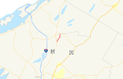
Eastern St. Lawrence and Franklin Counties
Massena (town), New York
Massena is a town in St. Lawrence County, New York, United States. The town is on the northern border of the county and is nicknamed "The Gateway to the Fourth Coast". The population was 13,121 at the 2000 census. The town of Massena contains a village also called Massena...
, NY 37 begins to parallel the north bank of the Raquette River
Raquette River
The Raquette River, sometimes spelled Racquette, originates at Raquette Lake in the Adirondack Mountains in New York. long, it is the third longest river entirely in the state of New York....
as it intersects NY 37C near a hamlet named for the waterway. NY 37 and the river continue northeast to the vicinity of the hamlet of Rooseveltown, where NY 37 connects to a large traffic circle
Traffic circle
A traffic circle or rotary is a type of circular intersection in which traffic must travel in one direction around a central island. In some countries, traffic entering the circle has the right-of-way and drivers in the circle must yield. In many other countries, traffic entering the circle must...
linking NY 37 to the Three Nations Crossing as well as County Route 45 (CR 45). Upon crossing into Franklin County
Franklin County, New York
Franklin County is a county located in the U.S. state of New York. As of the 2010 census, the population was 51,599. It is named in honor of American Founding Father Benjamin Franklin...
and the St. Regis Mohawk Reservation a short distance to the east, the road narrows back to a two-lane undivided highway and crosses over the Raquette River.
Although most of NY 37 in the town of Bombay
Bombay, New York
Bombay is a town in Franklin County, New York, United States. The population was 1,192 at the 2000 census. The town was named after a city in India, now known as Mumbai, by an early landowner whose wife was from Bombay....
is contained within the reservation, a short portion east of Hogansburg
Hogansburg, New York
Hogansburg is a hamlet in the St. Regis Mohawk Reservation, in Franklin County, in the town of Bombay in New York state, USA. It lies on NY 37 near the Canadian-US border at the confluence of the St. Regis River with the Saint Lawrence Seaway.-History:...
and the St. Regis River
St. Regis River
The St. Regis River is an river in northern New York in the USA. It flows into the Saint Lawrence River at the hamlet of St Regis in the St. Regis Mohawk Reservation. The Saint Regis River basin includes Upper and Lower St. Regis Lakes, and Saint Regis Pond in the Saint Regis Canoe Area.-External...
and west of Tarbell Road is located outside the reservation limits. Within this stretch, NY 37 meets both the eastern end of NY 37C and the northern terminus of NY 95
New York State Route 95
New York State Route 95 is a short state highway in northern New York, USA. NY 95 is a north–south route, connecting two towns in Franklin County. The southern terminus is at U.S. Route 11 in the hamlet of Moira in the town of Moira. The northern terminus is at NY 37...
. East of the reservation, NY 37 roughly parallels the CSX Transportation
CSX Transportation
CSX Transportation operates a Class I railroad in the United States known as the CSX Railroad. It is the main subsidiary of the CSX Corporation. The company is headquartered in Jacksonville, Florida, and owns approximately 21,000 route miles...
-owned Montreal Subdivision
Montreal Subdivision (CSX)
The Montreal Subdivision is a railroad line owned by the St. Lawrence and Adirondack Railway and CSX Transportation in the U.S. state of New York and Canadian province of Quebec. Operations are by CSX. The line originally ran from Massena, New York northeast to Kahnawake, Quebec along a former New...
northeast to Fort Covington
Fort Covington, New York
Fort Covington is a town in Franklin County, New York, United States. The population was 1,645 at the 2000 census. The name derives from a War of 1812 fortification.The Town of Fort Covington is on the county's northern border.- History :...
, where NY 37 crosses the railroad line and intersects Water Street (unsigned NY 970T), a connector to Quebec Route 132 on the northern side of the Canadian border.
East of Fort Covington, NY 37 follows a more southeasterly routing as it separates from the northernmost extents of the state. In the Westville
Westville, New York
Westville is a town in Franklin County, New York, United States. As of the 2000 census, the town had a total population of 1,823.The Town of Westville is on the north border of the county and is north of the Village of Malone.- History :...
hamlet of Westville Center, NY 37 meets the western terminus of NY 122
New York State Route 122
New York State Route 122 is an east–west state highway in northern Franklin County, New York, United States. The western terminus of the route is at an intersection with NY 37 in the town of Westville. Its eastern terminus is at a junction with U.S. Route 11 in the town of Burke...
. Farther south, NY 37 enters the village of Malone
Malone (village), New York
-Notable natives:Notable natives include:*William Almon Wheeler served as Vice President of the United States under Rutherford Hayes. Is buried at Morningside Cemetery in Malone....
, where it terminates at US 11
U.S. Route 11 in New York
U.S. Route 11 is a part of the U.S. Highway System that runs from New Orleans, Louisiana, to the Canadian border at Rouses Point, New York...
, NY 11B
New York State Route 11B
New York State Route 11B is a state highway in northern New York, United States. It provides a parallel, more southerly east–west route to U.S. Route 11 between US 11 in Potsdam and US 11, NY 30, and NY 37 in Malone...
and NY 30
New York State Route 30
New York State Route 30 is a state highway in the central part of New York in the United States. It extends for from an interchange with NY 17 in the Southern Tier to the Canadian border in the state's North Country, where it continues into Quebec as Route 138. On a regional level,...
.
History
The portion of NY 37 from RedwoodRedwood, New York
Redwood is a census-designated place in Jefferson County, New York, United States. As of the 2000 census, the area population was 584.Redwood is in the eastern part of the Town of Alexandria The community is near the southeast town line.-Geography:...
to Malone
Malone (village), New York
-Notable natives:Notable natives include:*William Almon Wheeler served as Vice President of the United States under Rutherford Hayes. Is buried at Morningside Cemetery in Malone....
was originally part of the Theodore Roosevelt International Highway
Theodore Roosevelt International Highway
The Theodore Roosevelt International Highway was a transcontinental North American highway through the United States and Canada that ran from Portland, Maine, to Portland, Oregon. Its length was about .-Route description:...
, an international auto trail
Auto trail
The system of auto trails was an informal network of marked routes that existed in the United States and Canada in the early part of the 20th century. Marked with colored bands on telephone poles, the trails were intended to help travellers in the early days of the automobile.Auto trails were...
connecting Portland, Maine
Portland, Maine
Portland is the largest city in Maine and is the county seat of Cumberland County. The 2010 city population was 66,194, growing 3 percent since the census of 2000...
, on the Atlantic Ocean
Atlantic Ocean
The Atlantic Ocean is the second-largest of the world's oceanic divisions. With a total area of about , it covers approximately 20% of the Earth's surface and about 26% of its water surface area...
coast to Portland, Oregon
Portland, Oregon
Portland is a city located in the Pacific Northwest, near the confluence of the Willamette and Columbia rivers in the U.S. state of Oregon. As of the 2010 Census, it had a population of 583,776, making it the 29th most populous city in the United States...
, east of the Pacific Ocean
Pacific Ocean
The Pacific Ocean is the largest of the Earth's oceanic divisions. It extends from the Arctic in the north to the Southern Ocean in the south, bounded by Asia and Australia in the west, and the Americas in the east.At 165.2 million square kilometres in area, this largest division of the World...
. When the first set of posted routes in New York
New York
New York is a state in the Northeastern region of the United States. It is the nation's third most populous state. New York is bordered by New Jersey and Pennsylvania to the south, and by Connecticut, Massachusetts and Vermont to the east...
were assigned in 1924, the entirety of the Roosevelt Highway in New York was designated NY 3
New York State Route 3
New York State Route 3 is a major east–west state highway in New York, United States, that connects central New York to the North Country region near the Canadian border via Adirondack Park. The route extends for between its western terminus at an intersection with NY 104A in the Cayuga...
. In the 1930 renumbering of state highways in New York, NY 3 was rerouted to follow its current routing between Watertown and Plattsburgh. The former routing of NY 3 along the St. Lawrence River became part of the new NY 37, which utilized a previously unnumbered highway between Watertown and Redwood via Theresa
Theresa (village), New York
Theresa is a village located in the Town of Theresa in Jefferson County, New York, USA. The population was 812 at the 2000 census.The Village of Theresa is northeast of Watertown.- History :...
. Initially, NY 37 directly served Theresa by way of modern CR 136, CR 46, and CR 193; however, it was realigned ca. 1934 to bypass the village to the west.
When NY 37 was first assigned, it entered Ogdensburg
Ogdensburg, New York
Ogdensburg is a city in St. Lawrence County, New York, United States. The population was 11,128 at the 2010 census. In the late 18th century, European-American settlers named the community after American land owner and developer Samuel Ogden....
on Main Street (modern NY 68
New York State Route 68
New York State Route 68 is an east–west state highway located entirely within St. Lawrence County in the North Country of New York in the United States. The western terminus is at an intersection with NY 37 in Oswegatchie, just west of the Ogdensburg city limits...
) and exited the city on Ford Street and Proctor Avenue. East of the city, NY 37 used less than 1 miles (1.6 km) of its modern alignment before turning south to follow Van Rensselaer Road to Waddington
Waddington (village), New York
Waddington is a village located in the Town of Waddington in St. Lawrence County, New York. The population was 923 at the 2000 census. The village is named after Joshua Waddington....
. The modern, riverside alignment of NY 37 between Ogdensburg and Waddington was designated as NY 37A as part of the 1930 renumbering. In the late 1950s, the alignments of NY 37 and NY 37A were flipped, placing NY 37 on its current routing and NY 37A on Van Rensselaer Road. During the same time period, NY 37 was rerouted to follow a new bypass around the southern edge of Ogdensburg.
In the Massena
Massena (village), New York
Massena is a village in St. Lawrence County, New York, United States. The population was 13,589 at the 2000 census. The village is named after Andre Massena, one of Napoleon's generals....
area, NY 37 originally broke from its modern alignment west of the village and followed what is now NY 37B
New York State Route 37B
New York State Route 37B is an east–west state highway located in St. Lawrence County, New York, United States. It serves as a business route of NY 37 through the village of Massena. While NY 37B enters the village, NY 37 bypasses it to the south. The western terminus of the...
east to Main Street. Here, it turned south onto Main Street to traverse the Grasse River
Grasse River
The Grasse River or Grass River is a river in northern New York, in the United States...
before continuing east on Orvis Street (and meeting modern NY 37B at Center Street) to reconnect to its current alignment east of the village. Lastly, from modern NY 131
New York State Route 131
New York State Route 131 is a long state highway in St. Lawrence County, New York, United States. It serves as a coastal alternate route to NY 37, going around the village of Massena instead of through it. NY 131 leaves NY 37 in the town of Louisville and rejoins it in the...
adjacent to the Massena International Airport
Massena International Airport
Massena International Airport , also known as Richards Field, is a public airport located two miles east of the central business district of Massena, a village in St. Lawrence County, New York, USA. The airport, owned by the Town of Massena, covers and has two runways...
to Rooseveltown
Rooseveltown, New York
Rooseveltown, New York is a hamlet in the town of Massena, New York, United States located in St. Lawrence County, New York. It is near the eastern town line by the Raquette River....
, NY 37 was initially routed on Trippany Road, NY 37C, and Roosevelt Road. In the mid-1950s, construction began on a new southern bypass of Massena that connected to NY 37 at the modern termini of NY 37B. It was completed and opened to traffic by 1958. Work on an eastward, divided highway
Divided Highway
Divided Highway is a compilation album by American rock band The Doobie Brothers, released in 2003. . All tracks are taken from the albums Cycles and Brotherhood .-Track listing:...
extension of the bypass to Rooseveltown began ca. 1961. The final section, from the hamlet of Raquette River to Rooseveltown, opened to traffic later that year.
Suffixed routes
- NY 37A was an alternate route of NY 37 between OgdensburgOgdensburg, New YorkOgdensburg is a city in St. Lawrence County, New York, United States. The population was 11,128 at the 2010 census. In the late 18th century, European-American settlers named the community after American land owner and developer Samuel Ogden....
and WaddingtonWaddington (village), New YorkWaddington is a village located in the Town of Waddington in St. Lawrence County, New York. The population was 923 at the 2000 census. The village is named after Joshua Waddington....
. It was assigned as part of the 1930 renumbering of state highways in New York to what is now NY 37 between the two locations. At the time, NY 37 was routed on Van Rensselaer Road. The alignments of NY 37 and NY 37A were flipped in the late 1950s. On April 10, 1980, the NY 37A designation was removed. Ownership and maintenance of Van Rensselaer Road was transferred from the state of New YorkNew YorkNew York is a state in the Northeastern region of the United States. It is the nation's third most populous state. New York is bordered by New Jersey and Pennsylvania to the south, and by Connecticut, Massachusetts and Vermont to the east...
to St. Lawrence CountySt. Lawrence County, New YorkSt. Lawrence County is a county located in the U.S. state of New York. As of the 2010 census, the population was 111,944. The county seat is Canton. The county is named for the Saint Lawrence River, which in turn was named for the Catholic saint on whose Feast day the river was discovered by...
on September 1, 1982, at which time the highway was redesignated as CR 28. - NY 37BNew York State Route 37BNew York State Route 37B is an east–west state highway located in St. Lawrence County, New York, United States. It serves as a business route of NY 37 through the village of Massena. While NY 37B enters the village, NY 37 bypasses it to the south. The western terminus of the...
(4.03 miles or 6.49 km) is the former routing of NY 37 through MassenaMassena (village), New YorkMassena is a village in St. Lawrence County, New York, United States. The population was 13,589 at the 2000 census. The village is named after Andre Massena, one of Napoleon's generals....
. NY 37B leaves NY 37 west of the village and rejoins its parent just east of Massena. It was assigned as part of the 1930 renumbering. - NY 37C (9.89 miles or 15.92 km) is a loop off of NY 37 in northeastern St. Lawrence CountySt. Lawrence County, New YorkSt. Lawrence County is a county located in the U.S. state of New York. As of the 2010 census, the population was 111,944. The county seat is Canton. The county is named for the Saint Lawrence River, which in turn was named for the Catholic saint on whose Feast day the river was discovered by...
and northwestern Franklin CountyFranklin County, New YorkFranklin County is a county located in the U.S. state of New York. As of the 2010 census, the population was 51,599. It is named in honor of American Founding Father Benjamin Franklin...
. While NY 37 follows a direct east–west routing between MassenaMassena (town), New YorkMassena is a town in St. Lawrence County, New York, United States. The town is on the northern border of the county and is nicknamed "The Gateway to the Fourth Coast". The population was 13,121 at the 2000 census. The town of Massena contains a village also called Massena...
and the BombayBombay, New YorkBombay is a town in Franklin County, New York, United States. The population was 1,192 at the 2000 census. The town was named after a city in India, now known as Mumbai, by an early landowner whose wife was from Bombay....
community of Hogansburg, NY 37C dips south to serve to the BrasherBrasher, New YorkBrasher is a town in St. Lawrence County, New York, USA. The population was 2,337 at the 2000 census. The town is named after Philip Brasher, an original landowner....
community of HelenaHelena, New YorkHelena is a hamlet in the Town of Brasher in St. Lawrence County, New York, United States.It is also known as "Ohi'karónthne", a Mohawk name which translates to: "at the place of the thorn bush"....
. NY 37C was assigned as part of the 1930 renumbering. - NY 37D was a spur connecting NY 37 to NY 26New York State Route 26New York State Route 26 is a north–south state highway that runs for through Central New York in the United States. Its southern terminus is located at the Pennsylvania state line south of the town of Vestal in Broome County, where it becomes Pennsylvania Route 267...
in TheresaTheresa (village), New YorkTheresa is a village located in the Town of Theresa in Jefferson County, New York, USA. The population was 812 at the 2000 census.The Village of Theresa is northeast of Watertown.- History :...
, utilizing part of NY 37's original alignment through the Theresa area. It was assigned ca. 1936 and removed in the mid-1960s. It is now maintained by Jefferson CountyJefferson County, New YorkJefferson County is a county located in the U.S. state of New York. As of the 2010 census, the population was 116,229. It is named after Thomas Jefferson, third President of the United States of America, and president at the time the county was created in 1805...
as CR 136 and CR 46.