
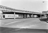
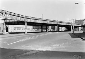
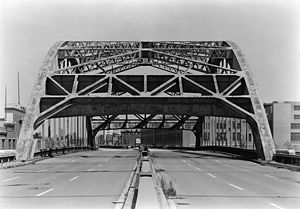
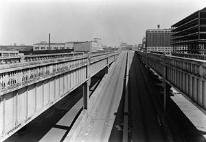
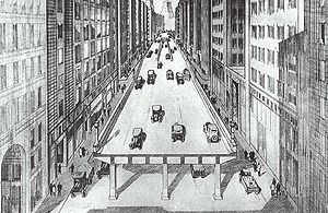
West Side Elevated Highway
Encyclopedia
Julius Miller
Julius Miller was a Manhattan Borough President from 1922 to 1930, who is best remembered for pushing through the West Side Elevated Highway from 72nd Street to the tip of Manhattan....
, Manhattan Borough President
Borough president
Borough President is an elective office in each of the five boroughs of New York City.-Reasons for establishment:...
from 1922 to 1930) was an elevated section of Route NY-9A
New York State Route 9A
New York State Route 9A is a state highway in the vicinity of New York City, New York, United States. Its southern terminus is at the northern end of the Brooklyn–Battery Tunnel in New York City, where it intersects with both Interstate 478 and FDR Drive. The northern terminus of...
running along the Hudson River
Hudson River
The Hudson is a river that flows from north to south through eastern New York. The highest official source is at Lake Tear of the Clouds, on the slopes of Mount Marcy in the Adirondack Mountains. The river itself officially begins in Henderson Lake in Newcomb, New York...
in the New York City
New York City
New York is the most populous city in the United States and the center of the New York Metropolitan Area, one of the most populous metropolitan areas in the world. New York exerts a significant impact upon global commerce, finance, media, art, fashion, research, technology, education, and...
borough
Borough (New York City)
New York City, one of the largest cities in the world, is composed of five boroughs. Each borough now has the same boundaries as the county it is in. County governments were dissolved when the city consolidated in 1898, along with all city, town, and village governments within each county...
of Manhattan
Manhattan
Manhattan is the oldest and the most densely populated of the five boroughs of New York City. Located primarily on the island of Manhattan at the mouth of the Hudson River, the boundaries of the borough are identical to those of New York County, an original county of the state of New York...
to the tip of the island.
It was an elevated highway, one of the first urban freeways in the world, and served as a prototype for urban freeways elsewhere, including Boston
Boston
Boston is the capital of and largest city in Massachusetts, and is one of the oldest cities in the United States. The largest city in New England, Boston is regarded as the unofficial "Capital of New England" for its economic and cultural impact on the entire New England region. The city proper had...
's Central Artery.
Built between 1929 and 1951, the highway's narrow confines –which could not accommodate trucks – and sharp S exit ramps made the highway obsolete almost immediately. When chunks of the highway's facade began to fall off due to lack of maintenance, and a truck and car fell through it at 14th Street
14th Street (Manhattan)
14th Street is a major crosstown street in the New York City borough of Manhattan. The street rivals the size of some of the well-known avenues of the city and is an important business location....
in 1973, the highway was shut down, and a debate began whether to renovate it or dismantle it. Attitudes about urban planning
Urban planning
Urban planning incorporates areas such as economics, design, ecology, sociology, geography, law, political science, and statistics to guide and ensure the orderly development of settlements and communities....
had changed in the intervening decades, and the decision was made not to repair the decaying structure.
A plan for the elevated highway to be replaced by an underground interstate-quality highway, which came to be called Westway, had originally been proposed in 1971. It received approval from many levels of government, from the City to the Federal, but was scuttled in 1985 due to environmental issues. In the interim between the closure of the elevated highway and the completion of its dismantling, while debate about Westway was proceeding, remaining sections of the old highway structure began to be unofficially utilized as an elevated urban park
Urban park
An urban park, is also known as a municipal park or a public park, public open space or municipal gardens , is a park in cities and other incorporated places to offer recreation and green space to residents of, and visitors to, the municipality...
, for jogging and bicycling.
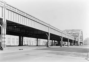
By 1989 the old elevated highway structure was totally dismantled, except for a small portion from 59th Street
59th Street (Manhattan)
59th Street in the New York City borough of Manhattan runs east-west, from York Avenue to the West Side Highway, with a discontinuity between Ninth Avenue/Columbus Avenue and Eighth Avenue/Central Park West for the Time Warner Center. Although it is bi-directional for most of its length, the...
to 72nd Street
72nd Street (Manhattan)
72nd Street is one of the major bi-directional crosstown streets in the New York City borough of Manhattan. Where the west end of 72nd Street curves into the south end of Riverside Drive, the memorial to Eleanor Roosevelt stands in Riverside Park. At this end of the street is the landmarked...
, which, in effect, became the southern extension of the Henry Hudson Parkway
Henry Hudson Parkway
The Henry Hudson Parkway is an long parkway in New York City. The southern terminus is at West 72nd Street in Manhattan, where the parkway continues south as the West Side Highway. It is often erroneously referred to as the West Side Highway throughout its entire course in Manhattan...
. Eventually, a grade-level six-to-eight lane "urban boulevard" was built, which is generally referred to as the West Side Highway
West Side Highway
The West Side Highway is a mostly surface section of New York State Route 9A that runs from West 72nd Street along the Hudson River to the southern tip of Manhattan. It replaced the West Side Elevated Highway, built between 1929 and 1951, which was shut down in 1973 due to neglect and lack of...
, although the elements of it use the names of the surface streets which existed before the elevated highway was built: West Street, 11th Avenue and 12th Avenue. It connects to the remaining elevated structure via a ramp at 57th Street
57th Street (Manhattan)
57th Street is one of New York City's major east-west thoroughfares, which runs east-west in the Midtown section of the borough of Manhattan, from the New York City Department of Sanitation's dock on the Hudson River at the West Side Highway to a small park overlooking the East River built on a...
.
Early planning
Death Avenue
Before the West Side Highway was built, the road along the Hudson RiverHudson River
The Hudson is a river that flows from north to south through eastern New York. The highest official source is at Lake Tear of the Clouds, on the slopes of Mount Marcy in the Adirondack Mountains. The river itself officially begins in Henderson Lake in Newcomb, New York...
was a busy one, with significant cross traffic going to dock
Dock (maritime)
A dock is a human-made structure or group of structures involved in the handling of boats or ships, usually on or close to a shore.However, the exact meaning varies among different variants of the English language...
s and ferries. At 22nd Street, most traffic continued north along 11th Avenue
Eleventh Avenue (Manhattan)
Eleventh Avenue is a north-south thoroughfare on the far West Side of the borough of Manhattan in New York City, not far from the Hudson River. It carries downtown traffic only, south of West 44th Street, and two-way traffic north of it....
, along which the New York Central Railroad
New York Central Railroad
The New York Central Railroad , known simply as the New York Central in its publicity, was a railroad operating in the Northeastern United States...
's West Side Line ran; it was known by many as Death Avenue for the large number of accidents caused by trains and automobiles colliding.
The first official proposal for an elevated highway along Manhattan's west side was made by Police Commissioner Richard Edward Enright on January 12, 1924, in a letter to the New York City Board of Estimate
New York City Board of Estimate
The New York City Board of Estimate was a governmental body in New York City, responsible for budget and land-use decisions. Under the charter of the newly amalgamated City of Greater New York the Board of Estimate and Apportionment was composed of eight ex officio members: the Mayor of New York...
. The highway was to be 100 feet (30 m) wide, running north from the Battery to 72nd Street
72nd Street (Manhattan)
72nd Street is one of the major bi-directional crosstown streets in the New York City borough of Manhattan. Where the west end of 72nd Street curves into the south end of Riverside Drive, the memorial to Eleanor Roosevelt stands in Riverside Park. At this end of the street is the landmarked...
at Riverside Drive
Riverside Drive (Manhattan)
Riverside Drive is a scenic north-south thoroughfare in the Manhattan borough of New York City. The boulevard runs on the west side of Manhattan, generally parallel to the Hudson River from 72nd Street to near the George Washington Bridge at 181st Street...
, West End Avenue, or Amsterdam Avenue. According to Enright, "During business hours West Street [was] the most congested
Traffic congestion
Traffic congestion is a condition on road networks that occurs as use increases, and is characterized by slower speeds, longer trip times, and increased vehicular queueing. The most common example is the physical use of roads by vehicles. When traffic demand is great enough that the interaction...
thoroughfare in the city. Vast quantities of the city's foodstuffs
Foodstuffs
Foodstuffs is a group of three New Zealand grocery and liquor retailers' cooperatives based in Auckland, Wellington and Christchurch which collectively control an estimated 57% of the New Zealand grocery market...
[were] handled in the territory adjacent to West Street." He cited traffic congestion as an extra cost of doing business and a blockage for fire engines
Fire apparatus
A fire apparatus, fire engine, fire truck, or fire appliance is a vehicle designed to assist in fighting fires by transporting firefighters to the scene and providing them with access to the fire, along with water or other equipment...
.
Double decker railroad/highway proposal
On February 2, 1925, it was announced that the railroad would build a combined double-decker elevated highway and freight railroad (with the highway above the railroad) for $24,000,000, at no cost to the city. At the time, Eleventh Avenue was popularly known as Death Avenue due to the dangers of the surface line. The elevated structure would eliminate 106 grade crossings over 84 blocks. The proposal came about after six months of negotiations between Manhattan Borough President Julius MillerJulius Miller
Julius Miller was a Manhattan Borough President from 1922 to 1930, who is best remembered for pushing through the West Side Elevated Highway from 72nd Street to the tip of Manhattan....
and the New York Central Railroad. The planned highway would no longer go all the way south to the Battery, instead ending at Canal Street
Canal Street (Manhattan)
Canal Street is a major street in New York City, crossing lower Manhattan to join New Jersey in the west to Brooklyn in the east . It forms the main spine of Chinatown, and separates it from Little Italy...
, meeting the Holland Tunnel (which would open to traffic on November 13, 1927). The northern terminus was set at 72nd Street
72nd Street (Manhattan)
72nd Street is one of the major bi-directional crosstown streets in the New York City borough of Manhattan. Where the west end of 72nd Street curves into the south end of Riverside Drive, the memorial to Eleanor Roosevelt stands in Riverside Park. At this end of the street is the landmarked...
and Riverside Drive
Riverside Drive (Manhattan)
Riverside Drive is a scenic north-south thoroughfare in the Manhattan borough of New York City. The boulevard runs on the west side of Manhattan, generally parallel to the Hudson River from 72nd Street to near the George Washington Bridge at 181st Street...
. Ramps were planned
at Canal Street
Canal Street (Manhattan)
Canal Street is a major street in New York City, crossing lower Manhattan to join New Jersey in the west to Brooklyn in the east . It forms the main spine of Chinatown, and separates it from Little Italy...
, 23rd Street
23rd Street (Manhattan)
23rd Street is a broad thoroughfare in the New York City borough of Manhattan. It is one of few two-way streets in the gridiron of the borough. As with Manhattan's other "crosstown" streets, it is divided at Fifth Avenue, in this case at Madison Square Park, into its east and west sections. Since...
, Riverside Drive
Riverside Drive (Manhattan)
Riverside Drive is a scenic north-south thoroughfare in the Manhattan borough of New York City. The boulevard runs on the west side of Manhattan, generally parallel to the Hudson River from 72nd Street to near the George Washington Bridge at 181st Street...
, and at least two other locations.
The Port of New York Authority opposed the plan, preferring a more forward-looking comprehensive freight distribution plan. They attacked Miller as trying to push the plan through without input from the Port Authority. The Port Authority wanted a system of inland terminals and belt-line railroads. According to Port Authority Chairman Julian Gregory, it was almost certain that the New York Central Railroad would not go along with the Port Authority plan. It was also believed that giving the New York Central Railroad elevated tracks on the west side would allow the railroad to monopolize freight and raise prices. The Port Authority believed it was primarily a freight problem, but the New York Central Railroad and New York City considered it to be a grade-crossing elimination project.
Miller responded by arguing that something had to be done right away. He said that if the Port Authority could put forward a comprehensive plan within five years, he would put his full support behind it. He also pointed out that his plan was only one part of his "comprehensive plan for the relief of traffic congestion"; he had already widened many avenues and removed several Midtown
Midtown Manhattan
Midtown Manhattan, or simply Midtown, is an area of Manhattan, New York City home to world-famous commercial zones such as Rockefeller Center, Broadway, and Times Square...
elevated railroad spurs. He said the plan would not give the New York Central any rights they didn't already have; it was merely a relocation of existing tracks. The tracks had been on the surface for 55 years despite legal action taken against them, and Miller claimed they would be there for another 50 if nothing were done. Miller also received a letter from the Vice President of the New York Central Railroad, Ira Place, stating that the railroad would reduce freight rates if the new elevated structure were built.
Miller's elevated single deck highway
Henry Hudson Parkway
The Henry Hudson Parkway is an long parkway in New York City. The southern terminus is at West 72nd Street in Manhattan, where the parkway continues south as the West Side Highway. It is often erroneously referred to as the West Side Highway throughout its entire course in Manhattan...
) at 72nd Street
72nd Street (Manhattan)
72nd Street is one of the major bi-directional crosstown streets in the New York City borough of Manhattan. Where the west end of 72nd Street curves into the south end of Riverside Drive, the memorial to Eleanor Roosevelt stands in Riverside Park. At this end of the street is the landmarked...
, forming a highway free from cross traffic stretching from Canal Street
Canal Street (Manhattan)
Canal Street is a major street in New York City, crossing lower Manhattan to join New Jersey in the west to Brooklyn in the east . It forms the main spine of Chinatown, and separates it from Little Italy...
to 129th Street. The elevated road was to be 60 feet (18 m) wide, wide enough for six lanes of traffic; the existing surface road would carry
local traffic beneath the highway. Ramps would be provided at Canal Street
Canal Street (Manhattan)
Canal Street is a major street in New York City, crossing lower Manhattan to join New Jersey in the west to Brooklyn in the east . It forms the main spine of Chinatown, and separates it from Little Italy...
, Christopher Street
Christopher Street (Manhattan)
Christopher Street is a street in the West Village neighborhood of the New York City borough of Manhattan. It is the continuation of 9th St. to the west of its intersection with 6th Ave. The Stonewall Inn is located on Christopher Street, and, therefore, the street was at the center of New York's...
, 14th Street
14th Street (Manhattan)
14th Street is a major crosstown street in the New York City borough of Manhattan. The street rivals the size of some of the well-known avenues of the city and is an important business location....
, 23rd Street
23rd Street (Manhattan)
23rd Street is a broad thoroughfare in the New York City borough of Manhattan. It is one of few two-way streets in the gridiron of the borough. As with Manhattan's other "crosstown" streets, it is divided at Fifth Avenue, in this case at Madison Square Park, into its east and west sections. Since...
, 34th Street
34th Street (Manhattan)
34th Street is a major cross-town street in the New York City borough of Manhattan, connecting the Lincoln Tunnel and Queens-Midtown Tunnel. Like many of New York City's major crosstown streets, it has its own bus routes and four subway stops serving the trains at Eighth Avenue, the trains at...
, 42nd Street
42nd Street (Manhattan)
42nd Street is a major crosstown street in the New York City borough of Manhattan, known for its theaters, especially near the intersection with Broadway at Times Square. It is also the name of the region of the theater district near that intersection...
, and 57th Street
57th Street (Manhattan)
57th Street is one of New York City's major east-west thoroughfares, which runs east-west in the Midtown section of the borough of Manhattan, from the New York City Department of Sanitation's dock on the Hudson River at the West Side Highway to a small park overlooking the East River built on a...
. Slow-moving traffic would use the left lanes, due to the left-hand ramps. This contrasts with the current method of using the left lane for passing and putting ramps on the right side, and to the method popular around the 1950s of putting ramps on whichever side was easier. The highway would "carry buses that will make both its conveniences and its beauties available to the general public", according to Miller. He suggested Hudson River Boulevard for the name of the highway.
On April 24, 1925, Governor Al Smith
Al Smith
Alfred Emanuel Smith. , known in private and public life as Al Smith, was an American statesman who was elected the 42nd Governor of New York three times, and was the Democratic U.S. presidential candidate in 1928...
signed a bill authorizing the construction of the highway. Funds for the $11,000,000 highway were to be procured by property assessments along the route; this was considered reasonable due to advantages gained from the highway by those living along the route. The road was to be 65 feet (20 m) wide, five feet wider than Fifth Avenue
Fifth Avenue (Manhattan)
Fifth Avenue is a major thoroughfare in the center of the borough of Manhattan in New York City, New York, United States. The section of Fifth Avenue that crosses Midtown Manhattan, especially that between 49th Street and 60th Street, is lined with prestigious shops and is consistently ranked among...
, with a speed limit of at least thirty miles per hour (50 km/h), and would be 20 feet (6 m) off the ground. It would be built of steel
Steel
Steel is an alloy that consists mostly of iron and has a carbon content between 0.2% and 2.1% by weight, depending on the grade. Carbon is the most common alloying material for iron, but various other alloying elements are used, such as manganese, chromium, vanadium, and tungsten...
, with a cement
Cement
In the most general sense of the word, a cement is a binder, a substance that sets and hardens independently, and can bind other materials together. The word "cement" traces to the Romans, who used the term opus caementicium to describe masonry resembling modern concrete that was made from crushed...
face. A three-foot (1 m) sidewalk would be built for pedestrians, although the highway was intended mainly for motor vehicles. Two-block long ramps would be provided with 'easy grades' for entering and exiting the highway. Trucks would be allowed on the highway.
The Board of Estimate approved the highway, now costing $13,500,000, on June 14, 1926. It was to be built so a second deck could be added at a later time for about $9,000,000, if traffic warranted. Controller Charles W. Berry questioned the proposal until he realized the money would come from tax assessments, at which time he agreed with the project.
On November 10, 1926, the Sinking Fund Commission voted to give the city title to the waterfront
Shore
A shore or shoreline is the fringe of land at the edge of a large body of water, such as an ocean, sea, or lake. In Physical Oceanography a shore is the wider fringe that is geologically modified by the action of the body of water past and present, while the beach is at the edge of the shore,...
property along the proposed highway. The highway plan was linked to a plan by the city for more piers for ocean steamships; since the highway required land takings between 47th Street
47th Street (Manhattan)
47th Street is an east-west running street between First Avenue and the West Side Highway in the borough of Manhattan in New York City. Traffic runs one way along the street, from east to west, starting at the United Nations Headquarters....
and 51st Street
51st Street (Manhattan)
51st Street is a long one-way street traveling east to west across Midtown Manhattan.-East 51st Street:*The route officially begins at Beekman Place which is on a hill overlooking FDR Drive...
, it was easier to combine the projects and prevent additional expense.
On February 17, 1927, the Board of Estimate adopted the final plans for the highway, setting a hearing date of March 24. It was split into two sections, Section one went from Canal Street
Canal Street (Manhattan)
Canal Street is a major street in New York City, crossing lower Manhattan to join New Jersey in the west to Brooklyn in the east . It forms the main spine of Chinatown, and separates it from Little Italy...
to 59th Street
59th Street (Manhattan)
59th Street in the New York City borough of Manhattan runs east-west, from York Avenue to the West Side Highway, with a discontinuity between Ninth Avenue/Columbus Avenue and Eighth Avenue/Central Park West for the Time Warner Center. Although it is bi-directional for most of its length, the...
. Section two was to carry the road over the New York Central Railroad
New York Central Railroad
The New York Central Railroad , known simply as the New York Central in its publicity, was a railroad operating in the Northeastern United States...
's 60th Street Yard from 59th Street
59th Street (Manhattan)
59th Street in the New York City borough of Manhattan runs east-west, from York Avenue to the West Side Highway, with a discontinuity between Ninth Avenue/Columbus Avenue and Eighth Avenue/Central Park West for the Time Warner Center. Although it is bi-directional for most of its length, the...
to 72nd Street
72nd Street (Manhattan)
72nd Street is one of the major bi-directional crosstown streets in the New York City borough of Manhattan. Where the west end of 72nd Street curves into the south end of Riverside Drive, the memorial to Eleanor Roosevelt stands in Riverside Park. At this end of the street is the landmarked...
. Section two was approved by the Board of Estimate on August 16, 1928; section one was postponed until September 27 due to objections. On October 18, the Board of Estimate approved section one.
The highway was advocated by most business interests, including the Downtown League, the Fifth Avenue Association, the West End Association, and eleven other organizations. They cited increasing traffic and the need of a bypass route to support the highway, which would cost little in comparison to its benefits.
Manhattan Borough President Julius Miller
Julius Miller
Julius Miller was a Manhattan Borough President from 1922 to 1930, who is best remembered for pushing through the West Side Elevated Highway from 72nd Street to the tip of Manhattan....
spoke at a meeting of the Market and Business Men's Association of the Greenwich and Chelsea
Chelsea, Manhattan
Chelsea is a neighborhood on the West Side of the borough of Manhattan in New York City. The district's boundaries are roughly 14th Street to the south, 30th Street to the north, the western boundary of the Ladies' Mile Historic District – which lies between the Avenue of the Americas and...
Districts on October 30, 1928, detailing plans for the highway. It was announced that between 90 and 100 meat and poultry dealers in the West Washington Market and the Gansevoort Market would be evicted to make way for the highway.
Minor changes to the highway were approved on January 10, 1929, in response to several objections. The alignment in the Chelsea district was slightly modified to avoid proposed piers, and the path through the markets was realigned to pass over a corner of the property. In addition, the 14th Street
14th Street (Manhattan)
14th Street is a major crosstown street in the New York City borough of Manhattan. The street rivals the size of some of the well-known avenues of the city and is an important business location....
ramps were moved to the area between 19th Street and 23rd Street
23rd Street (Manhattan)
23rd Street is a broad thoroughfare in the New York City borough of Manhattan. It is one of few two-way streets in the gridiron of the borough. As with Manhattan's other "crosstown" streets, it is divided at Fifth Avenue, in this case at Madison Square Park, into its east and west sections. Since...
, where they would spare many markets at 14th Street.
Art Society Objections
Thomas Adams (architect)
Thomas Adams was a pioneer of urban planning. Born on a farm near Edinburgh and a farmer in his early years, Adams moved to London where he worked as a journalist...
, Regional Plan director, at the 1927 meeting of the Municipal Art Society
Municipal Art Society
The Municipal Art Society of New York, founded in 1893, is a non-profit membership organization that fights for intelligent urban planning, design and preservation through education, dialogue and advocacy in New York City....
. He disapproved of its ugliness and noise, and suggested simply clearing obstructions to the existing surface road to speed traffic. Adams also supported a comprehensive regional plan for development in the Hudson Valley
Hudson Valley
The Hudson Valley comprises the valley of the Hudson River and its adjacent communities in New York State, United States, from northern Westchester County northward to the cities of Albany and Troy.-History:...
. The Fine Arts Federation also opposed the highway, saying that elevated structures were unsightly, and that if the existing street were cleared a new highway might not be required.
The City Club and New York City Mayor Jimmy Walker
Jimmy Walker
James John Walker, often known as Jimmy Walker and colloquially as Beau James , was the mayor of New York City from 1926 to 1932...
objected to the highway on the grounds that it would block waterfront-bound freight traffic. They believed that the plans should wait until the surface railroad tracks were removed in the area, at which point the elevated highway might not be necessary. Parallels were drawn with elevated passenger railroads, which were being torn down at the time; Henry Curran of the City Club called elevated structures "a misfit in New York". The City Club also objected to more passenger cars in downtown Manhattan.
Concerns were raised by the Women's League for the Protection of Riverside Park, which opposed routing trucks through Riverside Park
Riverside Park (Manhattan)
Riverside Park is a scenic waterfront public park on the Upper West Side of the borough of Manhattan in New York City, operated and maintained by the New York City Department of Parks and Recreation. The park consists of a narrow four-mile strip of land between the Hudson River and the gently...
, which would contain a parkway extending from the north end of the planned elevated highway. The League emphasized that commercial traffic should be banned north of 72nd Street
72nd Street (Manhattan)
72nd Street is one of the major bi-directional crosstown streets in the New York City borough of Manhattan. Where the west end of 72nd Street curves into the south end of Riverside Drive, the memorial to Eleanor Roosevelt stands in Riverside Park. At this end of the street is the landmarked...
(as it currently is on the Henry Hudson Parkway
Henry Hudson Parkway
The Henry Hudson Parkway is an long parkway in New York City. The southern terminus is at West 72nd Street in Manhattan, where the parkway continues south as the West Side Highway. It is often erroneously referred to as the West Side Highway throughout its entire course in Manhattan...
).
Exotic alternatives
An alternate plan was put forth by John HenckenJohn Hencken
John Frederick Hencken is a former international swimmer from the United States, who won five Olympic medals during his career, including three golds. The first one came at the 1972 Summer Olympics in Munich, West Germany, the other two four years later in Montreal, Canada.-References:...
, an engineer, and approved by Ernest P. Goodrich
Ernest P. Goodrich
-References:...
, consulting engineer to the Regional Plan of New York and its Environs. A linear corridor would be built from the Battery to Yonkers. A freight railroad would lie underground. On ground level would be roads alongside the corridor and an indoor enclosed sidewalk. The mezzanine, between the first and second floors, would be occupied by office space. The second floor would carry a "continuous noiseless moving platform system
Slidewalk
A slidewalk is a fictional moving sidewalk structurally sound enough to support buildings and large populations of travelers. Adjacent slidewalks moving at different rates could let travelers accelerate to great speeds....
for passenger service", with adjacent belts moving at various speeds, for a maximum of 21 miles per hour (34 km/h) in the middle. This service would be free, and would be a substitute for new subway
New York City Subway
The New York City Subway is a rapid transit system owned by the City of New York and leased to the New York City Transit Authority, a subsidiary agency of the Metropolitan Transportation Authority and also known as MTA New York City Transit...
s in the corridor. Above the second floor would be about ten stories of apartments, offices, businesses, and other uses appropriate for the neighborhoods; these would be the main source of revenue to pay for the project. A high-speed motor parkway, open to
passenger cars only, would lie on top. Cars would reach the upper level via ramps at both ends and elevators at convenient intervals.
Dr. Benjamin Battin, a professor at Swarthmore College
Swarthmore College
Swarthmore College is a private, independent, liberal arts college in the United States with an enrollment of about 1,500 students. The college is located in the borough of Swarthmore, Pennsylvania, 11 miles southwest of Philadelphia....
, Pennsylvania, had a similar plan for an eight-story high boulevard. The street level and first floor would be connected to the Hudson River
Hudson River
The Hudson is a river that flows from north to south through eastern New York. The highest official source is at Lake Tear of the Clouds, on the slopes of Mount Marcy in the Adirondack Mountains. The river itself officially begins in Henderson Lake in Newcomb, New York...
piers. The second and third stories would carry electric passenger trains, with the second floor carrying northbound traffic and southbound traffic using the third floor. A public garage would occupy the fourth and fifth floors, helping to pay off the bonds for the project. The sixth and seventh floors would carry one-way passenger car traffic, permitting speeds of up to fifty miles per hour (80 km/h). A reversible roadway, carrying cars in the direction of rush hour traffic, would occupy the eighth and ninth (top) levels. Ramps to the upper car levels would be provided every fifteen to twenty blocks.
Construction
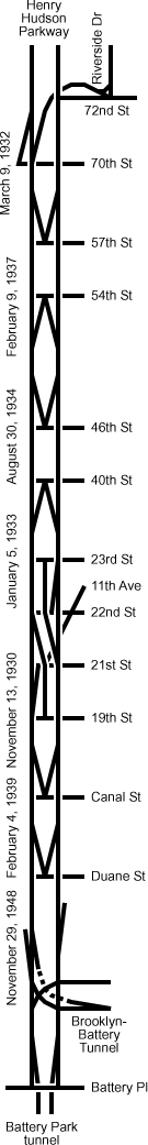
Canal Street to 22nd Street (1929-1930)
Construction on the first 1.5 mile (2.5 km) section, from Canal StreetCanal Street (Manhattan)
Canal Street is a major street in New York City, crossing lower Manhattan to join New Jersey in the west to Brooklyn in the east . It forms the main spine of Chinatown, and separates it from Little Italy...
to 22nd Street, was started on May 24, 1929, and the road was officially opened on November 13, 1930. Traffic was not permitted on the structure until November 17 due to unanticipated delays in cosmetic work. A speed limit of 35 miles per hour (55 km/h) was set by Police Commissioner Edward Mulrooney, and trucks were temporarily banned. On the first Sunday the road was in operation, the northbound roadway was backed up for a mile approaching the north end at 23rd Street
23rd Street (Manhattan)
23rd Street is a broad thoroughfare in the New York City borough of Manhattan. It is one of few two-way streets in the gridiron of the borough. As with Manhattan's other "crosstown" streets, it is divided at Fifth Avenue, in this case at Madison Square Park, into its east and west sections. Since...
. The northbound offramp at 23rd Street, unlike the temporary southbound onramp, was built as a permanent single lane ramp, since in the future most traffic would continue along the not-yet-finished elevated highway. Suggested fixes included a new temporary ramp to 25th Street and conversion of the temporary southbound onramp to two-way
traffic. The second Sunday the road was open, rain cut down on the traffic, but police had orders to open the permanent ramp eventually intended for a northbound onramp to exiting northbound traffic if traffic conditions warranted.
A temporary 45-foot (14 m) wide elevated street was proposed by the city between 29th Street and 37th Street to bypass the New York Central Railroad
New York Central Railroad
The New York Central Railroad , known simply as the New York Central in its publicity, was a railroad operating in the Northeastern United States...
's 30th Street Yard, to provide relief before the permanent highway was finished. It appears that this temporary viaduct was not built.
59th Street to 72nd Street (1930-1932)
The section from 59th Street59th Street (Manhattan)
59th Street in the New York City borough of Manhattan runs east-west, from York Avenue to the West Side Highway, with a discontinuity between Ninth Avenue/Columbus Avenue and Eighth Avenue/Central Park West for the Time Warner Center. Although it is bi-directional for most of its length, the...
to 72nd Street
72nd Street (Manhattan)
72nd Street is one of the major bi-directional crosstown streets in the New York City borough of Manhattan. Where the west end of 72nd Street curves into the south end of Riverside Drive, the memorial to Eleanor Roosevelt stands in Riverside Park. At this end of the street is the landmarked...
was begun in September 1930, and opened to traffic on March 9, 1932. The original configuration fed directly into 72nd Street
72nd Street (Manhattan)
72nd Street is one of the major bi-directional crosstown streets in the New York City borough of Manhattan. Where the west end of 72nd Street curves into the south end of Riverside Drive, the memorial to Eleanor Roosevelt stands in Riverside Park. At this end of the street is the landmarked...
, with a 90-degree turn in the road. Once the northern extension as a parkway was built, northbound traffic would turn right directly to and from 72nd Street. A southbound left-hand entrance ramp was provided at 72nd Street, with a direct ramp from Riverside Drive
Riverside Drive (Manhattan)
Riverside Drive is a scenic north-south thoroughfare in the Manhattan borough of New York City. The boulevard runs on the west side of Manhattan, generally parallel to the Hudson River from 72nd Street to near the George Washington Bridge at 181st Street...
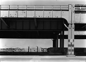
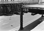
(later closed), and a southbound right-hand exit ramp to 70th Street was started, but never completed. This is the only elevated section that remains today, although it conflicts with the Riverside South development plan. A covered, at-grade replacement road to facilitate a southward expansion of Riverside Park
Riverside Park (Manhattan)
Riverside Park is a scenic waterfront public park on the Upper West Side of the borough of Manhattan in New York City, operated and maintained by the New York City Department of Parks and Recreation. The park consists of a narrow four-mile strip of land between the Hudson River and the gently...
was approved by the Federal Highway Administration in 2001.
22nd Street to 38th Street (1931-1933)
Construction of the elevated highway between 22nd Street and 38th Street was begun on August 19, 1931. The road was opened on January 5, 1933, just before Eleventh AvenueEleventh Avenue (Manhattan)
Eleventh Avenue is a north-south thoroughfare on the far West Side of the borough of Manhattan in New York City, not far from the Hudson River. It carries downtown traffic only, south of West 44th Street, and two-way traffic north of it....
was closed for reconstruction of the New York Central Railroad
New York Central Railroad
The New York Central Railroad , known simply as the New York Central in its publicity, was a railroad operating in the Northeastern United States...
's 30th Street Yard.
38th Street to 46th Street (1933-1934)
Construction on the highway between 38th Street and 46th Street was begun in late 1933. This section eliminated a busy intersection at 42nd Street42nd Street (Manhattan)
42nd Street is a major crosstown street in the New York City borough of Manhattan, known for its theaters, especially near the intersection with Broadway at Times Square. It is also the name of the region of the theater district near that intersection...
, where streetcars and automobiles crossed the corridor to reach the ferry to Weehawken, New Jersey
Weehawken, New Jersey
Weehawken is a township in Hudson County, New Jersey, United States. As of the 2010 United States Census, the township population was 12,554.-Geography:Weehawken is part of the New York metropolitan area...
. This link was opened to traffic on August 30, 1934.
When the new city piers at 48th Street, 50th Street
50th Street (Manhattan)
50th Street in the New York City borough of Manhattan. The street runs eastbound from 12th Avenue, across the full width of the island, ending at Beekman Place and carries the M50 bus line, which returns on 49th Street...
, and 52nd Street
52nd Street (Manhattan)
52nd Street is a long one-way street traveling west to east across Midtown Manhattan.-Jazz center:The blocks of 52nd Street between Fifth Avenue and Seventh Avenue were renowned in the mid-20th century for the abundance of jazz clubs and lively street life...
were being planned in late 1934, direct connections between the elevated highway and the second levels of the piers were proposed. Manhattan Borough President Samuel Levy quickly spoke against these connections, citing interference with southbound traffic on the highway. The plan, which had been proposed at the request of several cruise line
Cruise line
A cruise line is a company that operates cruise ships. Cruise lines have a dual character; they are partly in the transportation business, and partly in the leisure entertainment business, a duality that carries down into the ships themselves, which have both a crew headed by the ship's captain,...
s, was rejected.
In 1935, the 34th Street-Midtown Association proposed a new ramp for the highway at 34th Street
34th Street (Manhattan)
34th Street is a major cross-town street in the New York City borough of Manhattan, connecting the Lincoln Tunnel and Queens-Midtown Tunnel. Like many of New York City's major crosstown streets, it has its own bus routes and four subway stops serving the trains at Eighth Avenue, the trains at...
. This ramp would rise above the elevated railroad and highway, splitting into a northbound onramp and a southbound offramp, both on the right side of the highway. It was hoped that the ramp would help businesses in the area and provide better access to the proposed 38th Street Tunnel (now the Lincoln Tunnel
Lincoln Tunnel
The Lincoln Tunnel is a long tunnel under the Hudson River, connecting Weehawken, New Jersey and the borough of Manhattan in New York City.-History:...
) to New Jersey
New Jersey
New Jersey is a state in the Northeastern and Middle Atlantic regions of the United States. , its population was 8,791,894. It is bordered on the north and east by the state of New York, on the southeast and south by the Atlantic Ocean, on the west by Pennsylvania and on the southwest by Delaware...
. The ramp was never built.
46th Street to 59th Street (1936-1937)
Construction on the final section of the originally planned highway, from 46th Street to 59th Street59th Street (Manhattan)
59th Street in the New York City borough of Manhattan runs east-west, from York Avenue to the West Side Highway, with a discontinuity between Ninth Avenue/Columbus Avenue and Eighth Avenue/Central Park West for the Time Warner Center. Although it is bi-directional for most of its length, the...
, was begun on February 13, 1936. It was opened to traffic on February 9, 1937, thus completing the elevated highway from Canal Street
Canal Street (Manhattan)
Canal Street is a major street in New York City, crossing lower Manhattan to join New Jersey in the west to Brooklyn in the east . It forms the main spine of Chinatown, and separates it from Little Italy...
to 72nd Street
72nd Street (Manhattan)
72nd Street is one of the major bi-directional crosstown streets in the New York City borough of Manhattan. Where the west end of 72nd Street curves into the south end of Riverside Drive, the memorial to Eleanor Roosevelt stands in Riverside Park. At this end of the street is the landmarked...
.
Duane Street to Canal Street (1938-1939)
Canal Street (Manhattan)
Canal Street is a major street in New York City, crossing lower Manhattan to join New Jersey in the west to Brooklyn in the east . It forms the main spine of Chinatown, and separates it from Little Italy...
to the Battery. Construction on the first section of this, from Duane Street to Canal Street
Canal Street (Manhattan)
Canal Street is a major street in New York City, crossing lower Manhattan to join New Jersey in the west to Brooklyn in the east . It forms the main spine of Chinatown, and separates it from Little Italy...
, was begun on January 24, 1938. Unlike previous sections of highway, which used granite blocks as a surface, concrete
Concrete
Concrete is a composite construction material, composed of cement and other cementitious materials such as fly ash and slag cement, aggregate , water and chemical admixtures.The word concrete comes from the Latin word...
was used on the new section. The road was opened to traffic on February 4, 1939. A steel
Steel
Steel is an alloy that consists mostly of iron and has a carbon content between 0.2% and 2.1% by weight, depending on the grade. Carbon is the most common alloying material for iron, but various other alloying elements are used, such as manganese, chromium, vanadium, and tungsten...
superstructure
Superstructure
A superstructure is an upward extension of an existing structure above a baseline. This term is applied to various kinds of physical structures such as buildings, bridges, or ships...
was built at Canal Street
Canal Street (Manhattan)
Canal Street is a major street in New York City, crossing lower Manhattan to join New Jersey in the west to Brooklyn in the east . It forms the main spine of Chinatown, and separates it from Little Italy...
because the Holland Tunnel
Holland Tunnel
The Holland Tunnel is a highway tunnel under the Hudson River connecting the island of Manhattan in New York City with Jersey City, New Jersey at Interstate 78 on the mainland. Unusual for an American public works project, it is not named for a government official, politician, or local hero or...
below ground restricted locations of bridge supports.
Barclay to Duane Street (1947-1948)
After a long break due to World War IIWorld War II
World War II, or the Second World War , was a global conflict lasting from 1939 to 1945, involving most of the world's nations—including all of the great powers—eventually forming two opposing military alliances: the Allies and the Axis...
, construction on the final section of the southern extension, from Carlisle Street to Barclay Street, was begun on April 21, 1947. This section was expanded to reach Duane Street in the north, and was opened on November 29, 1948.
Battery to Barclay (1950-1951)
The southern end was connected to the Brooklyn-Battery TunnelBrooklyn-Battery Tunnel
Interstate 478s entire length consists of the Brooklyn–Battery Tunnel and its approaches. Its south end is at Interstate 278, and its north end is at NY 9A ....
on May 25, 1950. A four-lane tunnel under Battery Park
Battery Park
Battery Park is a 25-acre public park located at the Battery, the southern tip of Manhattan Island in New York City, facing New York Harbor. The Battery is named for artillery batteries that were positioned there in the city's early years in order to protect the settlement behind them...
, the Battery Park Underpass
Battery Park Underpass
The Battery Park Underpass was the second section of Manhattan's Franklin D. Roosevelt East River Drive to be completed, opening to the public in April 1951...
, taking traffic to the South Street Elevated Highway opened on April 10, 1951.
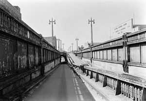
1973 collapse
Dump truck
A dump truck is a truck used for transporting loose material for construction. A typical dump truck is equipped with a hydraulically operated open-box bed hinged at the rear, the front of which can be lifted up to allow the contents to be deposited on the ground behind the truck at the site of...
, which was carrying over 30 tons (27,000 kg) of asphalt
Asphalt
Asphalt or , also known as bitumen, is a sticky, black and highly viscous liquid or semi-solid that is present in most crude petroleums and in some natural deposits, it is a substance classed as a pitch...
for ongoing repairs of the highway. A four-door sedan followed the truck through the hole; neither driver was seriously injured. The day after, both directions were 'indefinitely' closed south of 18th Street. Ironically, this not only closed off the oldest section (between Canal Street
Canal Street (Manhattan)
Canal Street is a major street in New York City, crossing lower Manhattan to join New Jersey in the west to Brooklyn in the east . It forms the main spine of Chinatown, and separates it from Little Italy...
and 18th Street), but also the newest sections (south of Canal Street), because of the placement of ramps to prevent northbound traffic from entering and southbound traffic from exiting south of Canal Street.
Ramps
The following exit ramps (and corresponding entrance ramps) were provided.- Brooklyn-Battery TunnelBrooklyn-Battery TunnelInterstate 478s entire length consists of the Brooklyn–Battery Tunnel and its approaches. Its south end is at Interstate 278, and its north end is at NY 9A ....
(direct southbound exit before the highway touched down to ground level) - Duane Street (southbound exit/northbound entrance)
- Canal StreetCanal Street (Manhattan)Canal Street is a major street in New York City, crossing lower Manhattan to join New Jersey in the west to Brooklyn in the east . It forms the main spine of Chinatown, and separates it from Little Italy...
(southbound exit/northbound entrance) - 19th Street (southbound exit)/23rd Street23rd Street (Manhattan)23rd Street is a broad thoroughfare in the New York City borough of Manhattan. It is one of few two-way streets in the gridiron of the borough. As with Manhattan's other "crosstown" streets, it is divided at Fifth Avenue, in this case at Madison Square Park, into its east and west sections. Since...
(northbound exit); entrances from 21st Street (southbound) and 22nd Street (northbound) - 40th Street (northbound exit/southbound entrance)
- 46th Street (southbound exit/northbound entrance)
- 54th Street54th Street (Manhattan)54th Street is a two-mile-long, one-way street traveling west to east across Midtown Manhattan.-West Side Highway:*The route begins at the West Side Highway . Opposite the intersection is the New York Passenger Ship Terminal and the Hudson River...
(northbound exit/southbound entrance) - 57th Street57th Street (Manhattan)57th Street is one of New York City's major east-west thoroughfares, which runs east-west in the Midtown section of the borough of Manhattan, from the New York City Department of Sanitation's dock on the Hudson River at the West Side Highway to a small park overlooking the East River built on a...
(southbound exit/northbound entrance) - 70th Street (southbound right-side exit only)
- 72nd Street72nd Street (Manhattan)72nd Street is one of the major bi-directional crosstown streets in the New York City borough of Manhattan. Where the west end of 72nd Street curves into the south end of Riverside Drive, the memorial to Eleanor Roosevelt stands in Riverside Park. At this end of the street is the landmarked...
(all but southbound exit; northbound ramps were on the right side; continued north as Henry Hudson ParkwayHenry Hudson ParkwayThe Henry Hudson Parkway is an long parkway in New York City. The southern terminus is at West 72nd Street in Manhattan, where the parkway continues south as the West Side Highway. It is often erroneously referred to as the West Side Highway throughout its entire course in Manhattan...
)
Sources
- Enright Asks City to Build Road in Air, New York Times 13 January 1924 page S6
- Great Crowd Treks Into Holland Tubes After Gala Opening, New York Times 13 November 1927 page 1+
- Central Offers City $24,000,000 Highway Along the West Side, New York Times 2 February 1925 page 1+
- Argue on Removal of West Side Tracks, New York Times 8 March 1925 page 16
- Fears Rail Project Imperils Port Plan, New York Times 19 February 1925 page 1+
- Censure Port Heads in 'Death Av' Delay, New York Times 4 December 1925 page 25
- Fears Rail Project Imperils Port Plan, New York Times 19 February 1925 page 1+
- Miller Proposes Biggest Boulevard to Ease West Side, New York Times 21 January 1926 page 1+
- New York to Build Elevated Highway, New York Times 25 April 1926 page XX1
- $13,500,000 Highway on West Side Voted, New York Times 15 June 1926 page 1
- New River Highway is Assured to City, New York Times 11 November 1926 page 3
- City Adopts Plans for Motor Highway, New York Times 18 February 1927 page 23
- Elevated Highway Along Hudson Shore is Ordered by City, New York Times 17 August 1928 page 1+
- Elevated Speedway is Approved in Full, New York Times 21 October 1928 page 33+
- Wants Express Highway, New York Times 8 June 1926 page 5
- Express Highway is Urged at Once, New York Times 31 October 1927 page 35
- Elevated Highway to Oust Merchants, New York Times 31 October 1928 page 61
- Express Highway Wins Final Vote, New York Times 11 January 1929 page 28
- Market to Escape Razing for Highway, New York Times 16 January 1929 page 14
- West Side Highway Project Criticized, New York Times 8 April 1927 page 48
- Raised Highway Opposed, New York Times 6 June 1927 page 10
- City Club Objects to Motor Highway, New York Times 16 May 1927 page 10
- Seek Plan to Guide Business Traffic, New York Times 14 November 1926 page E1
- Proposes Speedway on West Side Roofs, New York Times 28 March 1927 page 23
- Seeks 8-Story Road Along North River, New York Times 24 July 1927 page E17
- Hudson Highway Officially Started to Cheers of 5,000, New York Times 25 May 1929 page 1+
- Express Road Unit Opened by Miller, New York Times 14 November 1930 page 3
- Express Highway Opens, New York Times 18 November 1930 page 52
- Traffic Rush Jams West Side Highway, New York Times 24 November 1930 page 22
- Traffic Tie-Up Eased on Express Highway, New York Times 1 December 1930 page 21
- Temporary Viaduct for the West Side, New York Times 11 July 1930 page 3
- Pushes West Side Drive, New York Times 19 May 1931 page 27
- New Link is Opened in Express Highway, New York Times 10 March 1932 page 23
- Walker Will Open New Traffic Link, New York Times 7 March 1932 page 19
- New Highway Work is Started by Levy, New York Times 20 August 1931 page 17
- New Highway Link Opened by O'Brien, New York Times 6 January 1933 page 21
- Express Highway to Open New Link, New York Times 3 January 1933 page 3
- New Link Speeded for City Viaduct, New York Times 30 October 1933 page 35
- New Link Opened in West Side Road, New York Times 31 August 1934 page 19
- West Side Piers Started by Mayor, New York Times 4 November 1934 page 3
- Bars Speedway Change, New York Times 27 November 1934 page 2
- 34th St Group Elects, New York Times 10 January 1935 page 4
- New Plan Drafted for 34th St Ramp, New York Times 1 November 1935 page 23
- Last Link Started on West Side Drive, New York Times 14 February 1936 page 21
- Mayor Wins 'Auto Race' With Levy as Elevated Highway Link Opens, New York Times 10 February 1936 page 25
- Governor Signs Elevated Highway Bill for Link from Canal Street to Battery, New York Times 24 August 1934 page 1
- West Side Link to Start Jan. 24, New York Times 14 January 1938 page 25
- Concrete for Highway, New York Times 7 February 1938 page 2
- Canal St. Bridge Formally Opened, New York Times 5 February 1939 page 2
- Start Highway Link, New York Times 22 April 1947 page 29
- O'Dwyer Appeals for 'Bright Ideas', New York Times 30 November 1948 page 30
- Brooklyn Tunnel Costing $80,000,000 Opened by Mayor, New York Times 26 May 1950 page 1+
- City Opens Underpass at Battery, $10,000,000 Link in Express Route, New York Times 11 April 1951 page 31
- Truck and Car Fall as West Side Highway Collapses, New York Times 16 December 1973
- Indefinite Closing Is Set For West Side Highway, New York Times 17 December 1973 page 41
- Highway's Demise: Nightmare for Drivers, New York Times 6 January 1989 page B1+