

Brookhaven, New York
Encyclopedia
The Town of Brookhaven is one of the ten towns into which Suffolk County
, New York
, United States, has been divided. Part of the New York metropolitan area
, it is located in central Suffolk County and is the only town in the county that stretches from the North Shore
to the South Shore
of Long Island
. The population of the town was 448,248 at the 2000 census. It is the largest town (by area, if including water area) in the state of New York, and the second most populous, exceeded only by the Town of Hempstead in Nassau County
.
 According to the United States Census Bureau
, the town has a total area of 531.5 square miles (1,376.6 km²), of which 259.3 square miles (671.6 km²) is land and 272.2 square miles (705.1 km² or 51.22%) is water. It is the largest town in New York in terms of total area. Excluding water, however, there are four towns in the state with more land area: Webb
in Herkimer County
, Long Lake
in Hamilton County
, Arietta
in Hamilton County, and Ohio
in Herkimer County.
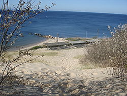
It has coastline on both the Atlantic Ocean
and Long Island Sound
. Riverhead
and Southampton
lie to the east, and Smithtown
and Islip
lie to the west.
A large part of Fire Island and the Great South Bay
are in the town.
It has a large hill, known as "Bald Hill
", in the hamlet of Farmingville, which marks where the glacier which formed Long Island stopped. At the top of Bald Hill is a Vietnam Veterans Memorial. Telescope Hill
, to the west of Bald Hill, is slightly taller and the highest point in the Town.
Brookhaven National Laboratory
is located within the town.
-speaking Native Americans
, of the Setauket and Unkechaug tribes. The first English settlers arrived in 1655 and purchased land from the inhabitants. Early English settlers farmed, fished, and hunted whales.
The first English settlement was named Setauket after the native American tribe. In 1666, Governor Richard Nicolls
granted a Patent for the town which confirmed title to the lands purchased, and permitted additional purchases. Governor Thomas Dongan issued a Patent in 1686 which granted powers to the town and established a representative form of government.
The letter "D" on the official seal, associated with the original Dongan patent officially establishing Brookhaven, is a cattle branding letter assigned to Brookhaven in the mid-17th century, along with whaling harpoons.
 As of the census
of 2000, there were 448,248 people, 146,828 households, and 112,910 families residing in the town. The population density
was 1,728.8 people per square mile (667.5/km²). There were 155,406 housing units at an average density of 599.4 per square mile (231.4/km²). The racial makeup of the town was 88.43% White, 4.33% Black or African American
, 0.23% Native American, 2.90% Asian, 0.03% Pacific Islander, 2.21% from other races
, and 1.87% from two or more races. Hispanic or Latino of any race were 8.04% of the population.
There were 146,828 households out of which 38.9% had children under the age of 18 living with them, 62.3% were married couples
living together, 10.6% had a female householder with no husband present, and 23.1% were non-families. 17.9% of all households were made up of individuals and 7.2% had someone living alone who was 65 years of age or older. The average household size was 2.97 and the average family size was 3.37.
In the town the population was spread out with 26.7% under the age of 18, 8.9% from 18 to 24, 31.5% from 25 to 44, 22.7% from 45 to 64, and 10.1% who were 65 years of age or older. The median age was 35 years. For every 100 females there were 96.7 males. For every 100 females age 18 and over, there were 93.8 males.
According to a 2006 estimate, the median income for a household in the town was $73,566, and the median income for a family was $84,705.http://factfinder.census.gov/servlet/ACSSAFFFacts?_event=Search&geo_id=06000US3602902000&_geoContext=01000US%7C04000US36%7C05000US36029%7C06000US3602902000&_street=&_county=brookhaven&_cityTown=brookhaven&_state=04000US36&_zip=&_lang=en&_sse=on&ActiveGeoDiv=geoSelect&_useEV=&pctxt=fph&pgsl=060&_submenuId=factsheet_1&ds_name=ACS_2006_SAFF&_ci_nbr=null&qr_name=null®=null%3Anull&_keyword=&_industry=]Males had a median income of $48,601 versus $32,157 for females. The per capita income
for the town was $24,191. About 3.9% of families and 5.9% of the population were below the poverty line, including 6.5% of those under age 18 and 6.6% of those age 65 or over.
Historical Population
(see also sidebox for U.S. census data)
1865 10,159
1845 7,461
1825 5,393
Prior to 2002, the Brookhaven Town Republican Party controlled the majority of the town board for several decades, except for a two year period in the mid-1970s when Democrats held a majority under Supervisor John Randolph. This one-party domination, and a series of scandals, led to a tarnished reputation of local politics accorded the nickname "Crookhaven".
In 2002, a voter proposition was passed to create council districts, replacing the prior system of electing the six town council members at-large. Steve Fiore-Rosenfield became the first Democrat to be elected since the 1970s in 2003. In 2005, Brian X. Foley
, a Democratic county legislator won the Town Supervisor race against Republican Councilman Edward Hennessy. In addition to Brian Foley, Constance Kepert and Carol Bissonette were also elected to the town board. As a result, the Democrats gained control of the Brookhaven town board.
Following the election of 2007, the Republican Party regained a majority on the Brookhaven Town Board, and elected Councilman Tim Mazzei as majority leader.
In 2008, Brian Foley was elected to the State Senate; he was replaced as Supervisor by Mark Lesko
, a Democrat, in a special election in early 2009. However, the Republicans retained their majority on the Town Council.
On November 14, 2009, Town Councilman Keith Romaine, son of Suffolk County Legislator Ed Romaine, died. A special election was held March 9, 2010 to fill the vacant seat, with Daniel Panico being the victor.
Current Town Board as of March 9, 2010
Supervisor Mark Lesko (D)
Town Clerk Patricia Eddington (former Assemblywoman)Non-Voting Member (D)
1st Council District Councilman Steve Fiore-Rosenfield (D)
2nd Council District Councilwoman Jane Bonner (C)
3rd Council District Councilwoman Kathleen Walsh (R)
4th Council District Councilwoman Constance Kepert (D)
5th Council District Councilman Timothy Mazzei (R)
6th Council District Councilman Daniel Panico (R)
Tax Receiver LOUIS J. MARCOCCIA (R)
 ----
----
Suffolk County, New York
Suffolk County is a county located in the U.S. state of New York on the eastern portion of Long Island. As of the 2010 census, the population was 1,493,350. It was named for the county of Suffolk in England, from which its earliest settlers came...
, New York
New York
New York is a state in the Northeastern region of the United States. It is the nation's third most populous state. New York is bordered by New Jersey and Pennsylvania to the south, and by Connecticut, Massachusetts and Vermont to the east...
, United States, has been divided. Part of the New York metropolitan area
New York metropolitan area
The New York metropolitan area, also known as Greater New York, or the Tri-State area, is the region that composes of New York City and the surrounding region...
, it is located in central Suffolk County and is the only town in the county that stretches from the North Shore
North Shore (Long Island)
The North Shore of Long Island is the area along Long Island's northern coast, bordering Long Island Sound. The region has long been the most affluent on Long Island, as well as the most affluent in the New York metropolitan area, which has earned it the nickname "the Gold Coast." Though some...
to the South Shore
South Shore (Long Island)
The South Shore of Long Island, in the U.S. state of New York, is the area along Long Island's Atlantic Ocean shoreline. Though some consider the South Shore to include parts of Queens, particularly the beach communities in the Rockaways such as Belle Harbor, the term is generally used to refer to...
of Long Island
Long Island
Long Island is an island located in the southeast part of the U.S. state of New York, just east of Manhattan. Stretching northeast into the Atlantic Ocean, Long Island contains four counties, two of which are boroughs of New York City , and two of which are mainly suburban...
. The population of the town was 448,248 at the 2000 census. It is the largest town (by area, if including water area) in the state of New York, and the second most populous, exceeded only by the Town of Hempstead in Nassau County
Nassau County, New York
Nassau County is a suburban county on Long Island, east of New York City in the U.S. state of New York, within the New York Metropolitan Area. As of the 2010 census, the population was 1,339,532...
.
Geography
United States Census Bureau
The United States Census Bureau is the government agency that is responsible for the United States Census. It also gathers other national demographic and economic data...
, the town has a total area of 531.5 square miles (1,376.6 km²), of which 259.3 square miles (671.6 km²) is land and 272.2 square miles (705.1 km² or 51.22%) is water. It is the largest town in New York in terms of total area. Excluding water, however, there are four towns in the state with more land area: Webb
Webb, New York
Webb is a the northernmost town in Herkimer County, New York, United States. The town is named after William Seward Webb, President of the Raquette Lake Transportation Company, the Fulton Chain Railway Company, Fulton Navigation Company, and the Mohawk and Malone Railway; his railroads were...
in Herkimer County
Herkimer County, New York
Herkimer County is a county located in the U.S. state of New York. It was created in 1791 north of the Mohawk River out of part of Montgomery County. As of the 2010 census, the population was 64,519. It is named after General Nicholas Herkimer, who died from battle wounds in 1777 after taking part...
, Long Lake
Long Lake, New York
Long Lake is a town in Hamilton County, New York in the United States. The population was 852 at the 2000 census. The town is named for long Long Lake beside which it sits. The town is entirely within the Adirondack Park and is the most northerly town in the county. It is a summer tourism...
in Hamilton County
Hamilton County, New York
Hamilton County is a county located in the U.S. state of New York. It is named after Alexander Hamilton, the only member of the New York State delegation who signed the United States Constitution in 1787 and later the first United States Secretary of the Treasury. Its county seat is Lake Pleasant...
, Arietta
Arietta, New York
Arietta is a town in Hamilton County, New York, United States. The population was 293 at the 2000 census. The town was named after the mother of one of the first settlers, Rensselaer Van Rennslaer...
in Hamilton County, and Ohio
Ohio, New York
Ohio is a town in Herkimer County, New York, United States. The population was 922 at the 2000 census. The town is named after the state of Ohio. The town is in the northwest part of the county and northeast of Utica. Part of Ohio is within the Adirondack Park....
in Herkimer County.
It has coastline on both the Atlantic Ocean
Atlantic Ocean
The Atlantic Ocean is the second-largest of the world's oceanic divisions. With a total area of about , it covers approximately 20% of the Earth's surface and about 26% of its water surface area...
and Long Island Sound
Long Island Sound
Long Island Sound is an estuary of the Atlantic Ocean, located in the United States between Connecticut to the north and Long Island, New York to the south. The mouth of the Connecticut River at Old Saybrook, Connecticut, empties into the sound. On its western end the sound is bounded by the Bronx...
. Riverhead
Riverhead (town), New York
The town of Riverhead is in Suffolk County, New York, on the north shore of Long Island. The population was 33,506 at the 2010 census. The name signifies that the mouth of the Peconic River is in this town...
and Southampton
Southampton (town), New York
The Town of Southampton is located in southeastern Suffolk County, New York, U.S., partly on the South Fork of Long Island. As of the United States 2000 Census, the town had a total population of 54,712...
lie to the east, and Smithtown
Smithtown, New York
As of the census of 2000, there were 115,715 people, 38,487 households, and 31,482 families residing in the town. The population density was 2,159.9 people per square mile . There were 39,357 housing units at an average density of 734.6 per square mile...
and Islip
Islip (town), New York
The Town of Islip is one of ten towns in Suffolk County, New York . Located on the south shore of Long Island, the town population was 322,612 at the 2000 census. The smaller, unincorporated hamlet of Islip lies within the town.-Demographics:...
lie to the west.
A large part of Fire Island and the Great South Bay
Great South Bay
Great South Bay is a lagoon situated between Long Island and Fire Island, in the State of New York. It is approximately long. It's protected from the Atlantic Ocean by Fire Island, a barrier island, as well as the eastern end of Jones Beach Island and Captree Island.Robert Moses Causeway adjoins...
are in the town.
It has a large hill, known as "Bald Hill
Bald Hill (Farmingville, New York)
Bald Hill, located in the hamlet of Farmingville, New York, part of the Town of Brookhaven, is one of the highest areas of elevation on Long Island. The highest elevation in the Bald Hill area is . Though local residents often claim it to be the highest point on Long Island, that honor actually...
", in the hamlet of Farmingville, which marks where the glacier which formed Long Island stopped. At the top of Bald Hill is a Vietnam Veterans Memorial. Telescope Hill
Telescope Hill
Telescope Hill, at , is the highest point of elevation in the Town of Brookhaven, on Long Island, New York, United States. The hill is located at the end of Tower Hill Ave., on the border of the ZIP codes of the hamlets of Selden and Farmingville, and west of Bald Hill.Notably, Telescope Hill was...
, to the west of Bald Hill, is slightly taller and the highest point in the Town.
Brookhaven National Laboratory
Brookhaven National Laboratory
Brookhaven National Laboratory , is a United States national laboratory located in Upton, New York on Long Island, and was formally established in 1947 at the site of Camp Upton, a former U.S. Army base...
is located within the town.
History
The first known inhabitants were AlgonquianAlgonquian languages
The Algonquian languages also Algonkian) are a subfamily of Native American languages which includes most of the languages in the Algic language family. The name of the Algonquian language family is distinguished from the orthographically similar Algonquin dialect of the Ojibwe language, which is a...
-speaking Native Americans
Native Americans in the United States
Native Americans in the United States are the indigenous peoples in North America within the boundaries of the present-day continental United States, parts of Alaska, and the island state of Hawaii. They are composed of numerous, distinct tribes, states, and ethnic groups, many of which survive as...
, of the Setauket and Unkechaug tribes. The first English settlers arrived in 1655 and purchased land from the inhabitants. Early English settlers farmed, fished, and hunted whales.
The first English settlement was named Setauket after the native American tribe. In 1666, Governor Richard Nicolls
Richard Nicolls
Richard Nicolls was the first English colonial governor of New York province....
granted a Patent for the town which confirmed title to the lands purchased, and permitted additional purchases. Governor Thomas Dongan issued a Patent in 1686 which granted powers to the town and established a representative form of government.
The letter "D" on the official seal, associated with the original Dongan patent officially establishing Brookhaven, is a cattle branding letter assigned to Brookhaven in the mid-17th century, along with whaling harpoons.
Demographics
Census
A census is the procedure of systematically acquiring and recording information about the members of a given population. It is a regularly occurring and official count of a particular population. The term is used mostly in connection with national population and housing censuses; other common...
of 2000, there were 448,248 people, 146,828 households, and 112,910 families residing in the town. The population density
Population density
Population density is a measurement of population per unit area or unit volume. It is frequently applied to living organisms, and particularly to humans...
was 1,728.8 people per square mile (667.5/km²). There were 155,406 housing units at an average density of 599.4 per square mile (231.4/km²). The racial makeup of the town was 88.43% White, 4.33% Black or African American
Race (United States Census)
Race and ethnicity in the United States Census, as defined by the Federal Office of Management and Budget and the United States Census Bureau, are self-identification data items in which residents choose the race or races with which they most closely identify, and indicate whether or not they are...
, 0.23% Native American, 2.90% Asian, 0.03% Pacific Islander, 2.21% from other races
Race (United States Census)
Race and ethnicity in the United States Census, as defined by the Federal Office of Management and Budget and the United States Census Bureau, are self-identification data items in which residents choose the race or races with which they most closely identify, and indicate whether or not they are...
, and 1.87% from two or more races. Hispanic or Latino of any race were 8.04% of the population.
There were 146,828 households out of which 38.9% had children under the age of 18 living with them, 62.3% were married couples
Marriage
Marriage is a social union or legal contract between people that creates kinship. It is an institution in which interpersonal relationships, usually intimate and sexual, are acknowledged in a variety of ways, depending on the culture or subculture in which it is found...
living together, 10.6% had a female householder with no husband present, and 23.1% were non-families. 17.9% of all households were made up of individuals and 7.2% had someone living alone who was 65 years of age or older. The average household size was 2.97 and the average family size was 3.37.
In the town the population was spread out with 26.7% under the age of 18, 8.9% from 18 to 24, 31.5% from 25 to 44, 22.7% from 45 to 64, and 10.1% who were 65 years of age or older. The median age was 35 years. For every 100 females there were 96.7 males. For every 100 females age 18 and over, there were 93.8 males.
According to a 2006 estimate, the median income for a household in the town was $73,566, and the median income for a family was $84,705.http://factfinder.census.gov/servlet/ACSSAFFFacts?_event=Search&geo_id=06000US3602902000&_geoContext=01000US%7C04000US36%7C05000US36029%7C06000US3602902000&_street=&_county=brookhaven&_cityTown=brookhaven&_state=04000US36&_zip=&_lang=en&_sse=on&ActiveGeoDiv=geoSelect&_useEV=&pctxt=fph&pgsl=060&_submenuId=factsheet_1&ds_name=ACS_2006_SAFF&_ci_nbr=null&qr_name=null®=null%3Anull&_keyword=&_industry=]Males had a median income of $48,601 versus $32,157 for females. The per capita income
Per capita income
Per capita income or income per person is a measure of mean income within an economic aggregate, such as a country or city. It is calculated by taking a measure of all sources of income in the aggregate and dividing it by the total population...
for the town was $24,191. About 3.9% of families and 5.9% of the population were below the poverty line, including 6.5% of those under age 18 and 6.6% of those age 65 or over.
Historical Population
(see also sidebox for U.S. census data)
1865 10,159
1845 7,461
1825 5,393
Top employers
According to Brookhaven's 2009 Comprehensive Annual Financial Report, the top employers in the city are:| # | Employer | # of Employees | Location |
|---|---|---|---|
| 1 | Stony Brook University | 13,623 | Stony Brook Stony Brook, New York Stony Brook is a hamlet located in the Town of Brookhaven in Suffolk County, New York, which is on the North Shore of Long Island... |
| 2 | Internal Revenue Service Internal Revenue Service The Internal Revenue Service is the revenue service of the United States federal government. The agency is a bureau of the Department of the Treasury, and is under the immediate direction of the Commissioner of Internal Revenue... |
3,332 | Holtsville Holtsville, New York Holtsville is a hamlet in Suffolk County, New York, United States. The population was 17,006 at the 2000 census.... |
| 3 | Sachem School District Sachem School District Sachem Central School District is one of the largest school districts by population on Long Island and among all suburban school districts in New York, United States. Founded in 1955, the district now encompasses residents of the Census-Designated Places of Holbrook, Holtsville and Farmingville, as... |
3,100 | Holbrook Holbrook, New York Holbrook is a hamlet and census-designated place in Suffolk County, New York, United States. The population was 27,512 at the 2000 Census.-Geography:Holbrook is located at .... |
| 4 | Brookhaven National Laboratory Brookhaven National Laboratory Brookhaven National Laboratory , is a United States national laboratory located in Upton, New York on Long Island, and was formally established in 1947 at the site of Camp Upton, a former U.S. Army base... |
2,500 | Upton Upton, New York Upton, New York is a hamlet on Long Island in the town of Brookhaven. It is the home of Brookhaven National Laboratory, and a National Weather Service station.Upton is located in Suffolk County, New York in the USA.... |
| 5 | John T. Mather Memorial Hospital | 2,047 | Port Jefferson Port Jefferson, New York The Incorporated Village of Port Jefferson is located in the town of Brookhaven in Suffolk County, New York on the North Shore of Long Island. As of the 2000 United States Census, the village population was 7,837... |
| 6 | Brookhaven Memorial Hospital Medical Center | 2,030 | East Patchogue East Patchogue, New York East Patchogue is a census-designated place in the Suffolk County town of Brookhaven, New York, United States. The population was 20,824 at the 2000 census. The CDP is a proximate representation of the East Patchogue hamlet used for statistical purposes of the Census Bureau... |
| 7 | St. Charles Hospital | 1,520 | Port Jefferson Port Jefferson, New York The Incorporated Village of Port Jefferson is located in the town of Brookhaven in Suffolk County, New York on the North Shore of Long Island. As of the 2000 United States Census, the village population was 7,837... |
| 8 | Three Village Central School District Three Village Central School District Three Village Central School District is a school district located in Long Island, New York. It serves Setauket, East Setauket, Stony Brook, Poquott, Old Field, and small portions of Port Jefferson Station, Saint James and South Setauket/Centereach... |
1,454 | East Setauket Setauket-East Setauket, New York Setauket-East Setauket is a census-designated place in Suffolk County, New York on the North Shore of Long Island along the "Gold Coast." As of the United States 2000 Census, the CDP population was 15,931. It is one of the most affluent communities in the state and is among the wealthiest towns... |
| 9 | Verizon | 1,440 | Patchogue Patchogue, New York -Notable citizens:* Franc D'Ambrosio, Broadway Actor, best known for being the longest running Phantom in Phantom of the Opera. Graduated Pat-Med HS 1981* Michael Fagan, professional bowler... |
| 10 | William Floyd School District William Floyd School District The William Floyd School District, located in southern Brookhaven, New York, serves the nearby communities of Shirley, Mastic, Mastic Beach, as well as Moriches. New York state is located in the U.S.A..Paul Casciano, Ed.D., is the superintendent of schools.... |
1,300 | Mastic Beach Mastic Beach, New York Mastic Beach is a village in the southeast part of the Town of Brookhaven in Suffolk County, New York, United States. The population was 11,543 at the 2000 census. The CDP is located in the general vicinity of the hamlet of Mastic Beach.... |
Government and Politics
Brookhaven government is led by a town Supervisor and a six-member Town Council, which are all two-year term elected positions. Council members are elected by district.Prior to 2002, the Brookhaven Town Republican Party controlled the majority of the town board for several decades, except for a two year period in the mid-1970s when Democrats held a majority under Supervisor John Randolph. This one-party domination, and a series of scandals, led to a tarnished reputation of local politics accorded the nickname "Crookhaven".
In 2002, a voter proposition was passed to create council districts, replacing the prior system of electing the six town council members at-large. Steve Fiore-Rosenfield became the first Democrat to be elected since the 1970s in 2003. In 2005, Brian X. Foley
Brian X. Foley
Brian X. Foley was a State Senator representing the 3rd District of the New York State Senate. He was elected to his first political office in 1993, representing the Seventh District in the Suffolk County Legislature. He was re-elected five times to the seat once held by his father, John Foley. In...
, a Democratic county legislator won the Town Supervisor race against Republican Councilman Edward Hennessy. In addition to Brian Foley, Constance Kepert and Carol Bissonette were also elected to the town board. As a result, the Democrats gained control of the Brookhaven town board.
Following the election of 2007, the Republican Party regained a majority on the Brookhaven Town Board, and elected Councilman Tim Mazzei as majority leader.
In 2008, Brian Foley was elected to the State Senate; he was replaced as Supervisor by Mark Lesko
Mark Lesko
Mark J. Lesko is an American politician and former Assistant U.S. Attorney. He recently won the special election for supervisor in the town of Brookhaven, New York. Lesko replaced former supervisor Brian X. Foley who was elected to the New York State senate in the November 2008...
, a Democrat, in a special election in early 2009. However, the Republicans retained their majority on the Town Council.
On November 14, 2009, Town Councilman Keith Romaine, son of Suffolk County Legislator Ed Romaine, died. A special election was held March 9, 2010 to fill the vacant seat, with Daniel Panico being the victor.
Current Town Board as of March 9, 2010
Supervisor Mark Lesko (D)
Town Clerk Patricia Eddington (former Assemblywoman)Non-Voting Member (D)
1st Council District Councilman Steve Fiore-Rosenfield (D)
2nd Council District Councilwoman Jane Bonner (C)
3rd Council District Councilwoman Kathleen Walsh (R)
4th Council District Councilwoman Constance Kepert (D)
5th Council District Councilman Timothy Mazzei (R)
6th Council District Councilman Daniel Panico (R)
Tax Receiver LOUIS J. MARCOCCIA (R)
Villages (incorporated)
Brookhaven has 9 villages:- Belle TerreBelle Terre, New YorkBelle Terre is a village in Suffolk County, New York, United States. The population was 832 at the 2000 census.The Incorporated Village of Belle Terre is in the Town of Brookhaven, on the North Shore of Long Island.-Geography:...
- BellportBellport, New YorkBellport is a village in Suffolk County, New York, United States. The population was 2,363 at the 2000 census. The village is named after the Bell family, early settlers of the area. The public education system in Bellport makes up the South Country Central School District consisting of six...
- Lake GroveLake Grove, New YorkLake Grove is a village in Suffolk County, New York, United States. The population was 10,250 at the 2000 census.The Village of Lake Grove is located in the Town of Brookhaven....
- Mastic BeachMastic Beach, New YorkMastic Beach is a village in the southeast part of the Town of Brookhaven in Suffolk County, New York, United States. The population was 11,543 at the 2000 census. The CDP is located in the general vicinity of the hamlet of Mastic Beach....
- Old FieldOld Field, New YorkOld Field is a village of 918 residents in Suffolk County, New York, United States. The Incorporated Village of Old Field is in the town of Brookhaven, on the North Shore of Long Island. It is one of the most affluent communities in the state and is among the wealthiest towns in the United States...
- PatchoguePatchogue, New York-Notable citizens:* Franc D'Ambrosio, Broadway Actor, best known for being the longest running Phantom in Phantom of the Opera. Graduated Pat-Med HS 1981* Michael Fagan, professional bowler...
- PoquottPoquott, New YorkPoquott is a village in Suffolk County, New York, United States. The population was 975 at the 2000 census.The Incorporated Village of Poquott is within the Town of Brookhaven, on the North Shore of Long Island.-Geography:...
- Port JeffersonPort Jefferson, New YorkThe Incorporated Village of Port Jefferson is located in the town of Brookhaven in Suffolk County, New York on the North Shore of Long Island. As of the 2000 United States Census, the village population was 7,837...
- ShorehamShoreham, New YorkShoreham is an incorporated village in Suffolk County, New York, United States. The population was 417 at the 2000 census.The Incorporated Village of Shoreham is inside the Town of Brookhaven.-Geography:Shoreham is located at ....
Hamlets (unincorporated)
Brookhaven includes all or part of 50 hamlets. One of those hamlets is also named Brookhaven.See More
|