
,_new_york.gif)
Skaneateles (village), New York
Encyclopedia
Skaneateles (ˌskæniˈætləs, ˌskɪniˈætləs) is a village in the town of Skaneateles
, Onondaga County
, New York
, United States
. The village is named from and located on the shores of Skaneateles Lake
, one of the Finger Lakes
. The village, as of the 2000 census, has a population of 2,616 residents. The main highway through the community is U.S. Route 20
, which heads out towards Auburn
. US 20 and Skaneateles also serve as the northern terminus of New York State Route 41
and its suffixed route, New York State Route 41A
.
Skaneateles, and the territory that makes up the town was originally placed in 1794 as part of nearby Marcellus, New York
. Although the thought was that a man named John Thompson was the first permanent Caucasian
settler in the area, facts and research have proved that Abraham A. Cuddeback was the first, arriving in 1794 from Minisink, New York
. After beginning to build up the area in current-day Skaneateles, Cuddeback died in 1831. The town and village of Skaneateles were annexed from Marcellus and Spafford
on February 26, 1830 and March 18, 1840 respectively.
 Settlers populated the eastern Finger Lakes
region rapidly in the 1790s. Water power from the outlet from Skaneateles Lake made the site of the present village attractive. The old Genesee Road between Utica
, Marcellus, Auburn, Geneva
and Avon
became the Seneca Turnpike in 1800; the first bridge across Skaneateles Creek was built that year. The Seneca Turnpike, together with the Hamilton and Skaneateles Turnpike, begun in 1826, made the new community more accessible. Isaac Sherwood, founder of the Sherwood Inn, developed a stage coach line through Skaneateles.
The village, incorporated
in 1833 and 1855, attracted prominent residents from an early date. In 1803 a major New York State landowner from New York City, William J. Vredenburgh, erected an ambitious mansion. In 1839 Nicholas Roosevelt
, another New York State landowner and "one of the leading industrial entrepreneurs of the period [who] had built the big steam engines for the Philadelphia waterwork", on retiring moved with his wife, Lydia Latrobe (daughter of the famous architect, Benjamin Henry Latrobe) from New York City to Skaneateles.
 In the same year, Richard DeZeng, an engineer and canal builder retiring from Oswego, NY, completed his landmark mansion on the lake. Acquired forty years later by another of several members of the Roosevelt family, Samuel Morris Roosevelt, the Greek Revival house became known as "Roosevelt Hall."
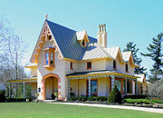
Reuel Smith, a wealthy Massachusetts importer, retired to Skaneateles. In 1852 he built an architecturally distinguished house, designed in the Gothic Revival style by Alexander Jackson Davis
, who designed at least one other building in the village. The Reuel Smith House has been designated to the National Reguistry, the plans are in the Library of Congress, all made possible by the local owners.
Roosevelt Hall, originally the DeZeng House furthermore may be the work of his partner, Ithiel Town
. Frederick Roosevelt, cousin of President Theodore Roosevelt, built a fine house on the lake in 1879, said to be designed by Stanford White
(although the architect was in Europe at the time). The building reputedly was constructed in New York City, dismantled and relocated in Auburn, New York
.
Many early residents such as James Canning Fuller came from Great Britain
, largely because of the Quaker
community here, giving the early village a cosmopolitan tone. Fuller and his wife, Lydia, maintained an active Underground Railroad
station at their village home (built 1815, extant at 98 Genesee Street). Fuller was co-founder of the British-American Institute
, a Canadian school for fugitive slaves, together with the adjoining settlement of Dawn, near Dresden, Ontario
.
For more than two centuries Skaneateles has also attracted visitors. An excursion boat, launched in 1816, probably was the first instance of commercial tourist recreation in the Finger Lakes
region.
 Skaneateles is located at 42°56′48"N 76°25′42"W (42.946893, -76.428586)
According to the United States Census Bureau
, the village has a total area of 1.7 square miles (4.5 km²), of which, 1.4 square miles (3.7 km²) of it is land and 0.3 square miles (0.7 km²) of it (16.28%) is water.
The village is at the north end of Skaneateles Lake
, in the eastern end of the Finger Lakes
District.
The village is at the junction of US Route 20, an east-west highway, and three north-south highways, New York State Route 321
, New York State Route 41
and New York State Route 41A
.
of 2000, there were 2,616 people, 1,104 households, and 705 families residing in the village. The population density
was 1,826.8 people per square mile (706.3/km²). There were 1,190 housing units at an average density of 831.0 per square mile (321.3/km²). The racial makeup of the village was 99.16% White, 0.08% Black or African American
, 0.31% Asian, 0.04% from other races
, and 0.42% from two or more races. Hispanic or Latino of any race were 0.31% of the population.
There were 1,104 households out of which 31.4% had children under the age of 18 living with them, 53.9% were married couples
living together, 7.8% had a female householder with no husband present, and 36.1% were non-families. 33.0% of all households were made up of individuals and 18.8% had someone living alone who was 65 years of age or older. The average household size was 2.35 and the average family size was 3.03.
In the village, the population was spread out with 25.8% under the age of 18, 4.3% from 18 to 24, 22.9% from 25 to 44, 27.6% from 45 to 64, and 19.5% who were 65 years of age or older. The median age was 44 years. For every 100 females, there were 87.0 males. For every 100 females age 18 and over, there were 80.1 males.
The median income for a household in the village was $57,083, and the median income for a family was $85,403. Males had a median income of $60,529 versus $36,797 for females. The per capita income
for the village was $29,170. About 0.9% of families and 3.0% of the population were below the poverty line, including 0.8% of those under age 18 and 5.9% of those age 65 or over. In 2006, 164 residential properties in the Town of Skaneateles were assessed at more than a million dollars, compared to only two such properties in all the rest of Onondaga County.
The Village has recently been embroiled in a controversy with the trucking industry which uses roads in the village to reduce travel time and bypass tolls on the New York State Thruway. Most of the truck traffic in question is hauling garbage from New York City to a landfill near Seneca Falls, NY. The State of New York is currently considering restrictions on this truck traffic. In November 2008, truckers staged a massive convoy through the Village during its popular holiday-time Dickens Festival.
The area encompassed by the Village boundary also falls under the governance of the Town of Skaneateles, which has its own elected officials and staff.
In the latest Village and Town Joint Comprehensive Plan, adopted in 2005, there is discussion about the possibility of consolidating the Town and Village into a single government to reduce redundancies and create efficiencies. The debate and discussion on this topic continues today, including during the most recent Town Board elections. The State government has passed legislation to ease such consolidations under the premise that they would create efficiencies and reduce tax burdens.
.jpg)
 The Village consists of a small commercial core with surrounding residential streets. Skaneateles' downtown area sits immediately on the lake, which gives the village a distinctive look and feel. There are three publicly accessible parks on the lake within the downtown area. The main commercial streets in the village are Genesee Street (U.S. Route 20), Jordan Road, and Fennell Street. Genesee and Jordan are noted for their mix of mid-nineteenth and early 20th century retail buildings which today contain a mix of retailers, including restaurants, boutiques, real estate offices, and banks. Fennell Street, which has a more industrial history and was the alignment for the railroad spur that served the village until the mid-20th century, contains more of the auto-oriented retail, including a supermarket, pharmacies, and post office.
Village attractions include boat excursions, inns, restaurants and a spa, as well as boutique shopping and art galleries. The summer Skaneateles Festival of music is a seasonal event, as is the annual Skaneateles Antique and Classic Boat Show and the Dickens Christmas in Skaneateles with actors in period costume performing on the streets.
Skaneateles (town), New York
Skaneateles is a town in Onondaga County, New York, United States. The population was 7,323 at the 2000 census. The name is from the Iroquois "Indian" tribe term for the adjacent lake: "long lake." The town is on the western border of the county and includes a village, also called Skaneateles...
, Onondaga County
Onondaga County, New York
Onondaga County is a county located in the U.S. state of New York. As of the 2010 census, the population was 467,026. The county seat is Syracuse.Onondaga County is part of the Syracuse, NY Metropolitan Statistical Area....
, New York
New York
New York is a state in the Northeastern region of the United States. It is the nation's third most populous state. New York is bordered by New Jersey and Pennsylvania to the south, and by Connecticut, Massachusetts and Vermont to the east...
, United States
United States
The United States of America is a federal constitutional republic comprising fifty states and a federal district...
. The village is named from and located on the shores of Skaneateles Lake
Skaneateles Lake
Skaneateles Lake is one of the Finger Lakes in central New York in the United States. The name Skaneateles means long lake in one of the local Iroquoian languages. The lake is sometimes referred to as "The Roof Garden of the Lakes" because its altitude is higher than the other Finger Lakes. It...
, one of the Finger Lakes
Finger Lakes
The Finger Lakes are a pattern of lakes in the west-central section of Upstate New York in the United States. They are a popular tourist destination. The lakes are long and thin , each oriented roughly on a north-south axis. The two longest, Cayuga Lake and Seneca Lake, are among the deepest in...
. The village, as of the 2000 census, has a population of 2,616 residents. The main highway through the community is U.S. Route 20
U.S. Route 20 in New York
U.S. Route 20 is a part of the U.S. Highway System that runs from Newport, Oregon, to Boston, Massachusetts. In the U.S. state of New York, US 20 extends from the Pennsylvania state line at Ripley to the Massachusetts state line in the Berkshire Mountains. US 20 is the longest...
, which heads out towards Auburn
Auburn, New York
Auburn is a city in Cayuga County, New York, United States of America. As of the 2010 census, the city had a population of 27,687...
. US 20 and Skaneateles also serve as the northern terminus of New York State Route 41
New York State Route 41
New York State Route 41 is a north–south state highway in Central New York, United States. The southern terminus of the route is at an interchange with NY 17 in the town of Sanford. Its northern terminus is at an intersection with U.S. Route 20 in the village of Skaneateles...
and its suffixed route, New York State Route 41A
New York State Route 41A
New York State Route 41A is a north–south New York State Route located within Onondaga, Cayuga, and Cortland Counties in Central New York. Its northern terminus is located at a junction with U.S. Route 20 in the village of Skaneateles in Onondaga County...
.
Skaneateles, and the territory that makes up the town was originally placed in 1794 as part of nearby Marcellus, New York
Marcellus (town), New York
Marcellus is a town in Onondaga County, New York, United States. The population was 6,319 at the 2000 census. The town was probably named after Marcus Claudius Marcellus, a Roman general, by a clerk interested in the Classics....
. Although the thought was that a man named John Thompson was the first permanent Caucasian
White people
White people is a term which usually refers to human beings characterized, at least in part, by the light pigmentation of their skin...
settler in the area, facts and research have proved that Abraham A. Cuddeback was the first, arriving in 1794 from Minisink, New York
Minisink, New York
Minisink is a town located in southwest Orange County, New York northeast of the New Jersey border between the Town of Greenville and the Town of Warwick...
. After beginning to build up the area in current-day Skaneateles, Cuddeback died in 1831. The town and village of Skaneateles were annexed from Marcellus and Spafford
Spafford, New York
Spafford is a town in Onondaga County, New York, United States. The population was 1,661 at the 2000 census. The town was named after Horatio Gates Spafford, a writer and founder of the local library....
on February 26, 1830 and March 18, 1840 respectively.
History
Finger Lakes
The Finger Lakes are a pattern of lakes in the west-central section of Upstate New York in the United States. They are a popular tourist destination. The lakes are long and thin , each oriented roughly on a north-south axis. The two longest, Cayuga Lake and Seneca Lake, are among the deepest in...
region rapidly in the 1790s. Water power from the outlet from Skaneateles Lake made the site of the present village attractive. The old Genesee Road between Utica
Utica, New York
Utica is a city in and the county seat of Oneida County, New York, United States. The population was 62,235 at the 2010 census, an increase of 2.6% from the 2000 census....
, Marcellus, Auburn, Geneva
Geneva, New York
Geneva is a city in Ontario and Seneca counties in the U.S. state of New York. The population was 13,617 at the 2000 census. Some claim it is named after the city and canton of Geneva in Switzerland. Others believe the name came from confusion over the letters in the word "Seneca" written in cursive...
and Avon
Avon, New York
Avon, New York is the name of two places located in Livingston County in the State of New York in the United States of America.*Avon , New York*Avon , New York...
became the Seneca Turnpike in 1800; the first bridge across Skaneateles Creek was built that year. The Seneca Turnpike, together with the Hamilton and Skaneateles Turnpike, begun in 1826, made the new community more accessible. Isaac Sherwood, founder of the Sherwood Inn, developed a stage coach line through Skaneateles.
The village, incorporated
Municipal corporation
A municipal corporation is the legal term for a local governing body, including cities, counties, towns, townships, charter townships, villages, and boroughs. Municipal incorporation occurs when such municipalities become self-governing entities under the laws of the state or province in which...
in 1833 and 1855, attracted prominent residents from an early date. In 1803 a major New York State landowner from New York City, William J. Vredenburgh, erected an ambitious mansion. In 1839 Nicholas Roosevelt
Nicholas Roosevelt (inventor)
Nicholas Isaac Roosevelt was an American inventor, a major investor in Upstate New York land, and a member of the Roosevelt family. His primary invention was to introduce vertical paddle wheels for steamboats.-Inventor:Nicholas Roosevelt was carefully educated...
, another New York State landowner and "one of the leading industrial entrepreneurs of the period [who] had built the big steam engines for the Philadelphia waterwork", on retiring moved with his wife, Lydia Latrobe (daughter of the famous architect, Benjamin Henry Latrobe) from New York City to Skaneateles.
Reuel Smith, a wealthy Massachusetts importer, retired to Skaneateles. In 1852 he built an architecturally distinguished house, designed in the Gothic Revival style by Alexander Jackson Davis
Alexander Jackson Davis
Alexander Jackson Davis, or A. J. Davis , was one of the most successful and influential American architects of his generation, in particular his association with the Gothic Revival style....
, who designed at least one other building in the village. The Reuel Smith House has been designated to the National Reguistry, the plans are in the Library of Congress, all made possible by the local owners.
Roosevelt Hall, originally the DeZeng House furthermore may be the work of his partner, Ithiel Town
Ithiel Town
Ithiel Town was a prominent American architect and civil engineer. One of the first generation of professional architects in the United States, Town made significant contributions to American architecture in the first half of the 19th century. He was high-strung, sophisticated, generous,...
. Frederick Roosevelt, cousin of President Theodore Roosevelt, built a fine house on the lake in 1879, said to be designed by Stanford White
Stanford White
Stanford White was an American architect and partner in the architectural firm of McKim, Mead & White, the frontrunner among Beaux-Arts firms. He designed a long series of houses for the rich and the very rich, and various public, institutional, and religious buildings, some of which can be found...
(although the architect was in Europe at the time). The building reputedly was constructed in New York City, dismantled and relocated in Auburn, New York
Auburn, New York
Auburn is a city in Cayuga County, New York, United States of America. As of the 2010 census, the city had a population of 27,687...
.
Many early residents such as James Canning Fuller came from Great Britain
Great Britain
Great Britain or Britain is an island situated to the northwest of Continental Europe. It is the ninth largest island in the world, and the largest European island, as well as the largest of the British Isles...
, largely because of the Quaker
Religious Society of Friends
The Religious Society of Friends, or Friends Church, is a Christian movement which stresses the doctrine of the priesthood of all believers. Members are known as Friends, or popularly as Quakers. It is made of independent organisations, which have split from one another due to doctrinal differences...
community here, giving the early village a cosmopolitan tone. Fuller and his wife, Lydia, maintained an active Underground Railroad
Underground Railroad
The Underground Railroad was an informal network of secret routes and safe houses used by 19th-century black slaves in the United States to escape to free states and Canada with the aid of abolitionists and allies who were sympathetic to their cause. The term is also applied to the abolitionists,...
station at their village home (built 1815, extant at 98 Genesee Street). Fuller was co-founder of the British-American Institute
British-American Institute
The British-American Institute was a school started in 1842 by Josiah Henson near Dresden, Western District, Canada West, Province of Canada, as part of the Dawn Settlement, a community of fugitive slaves who had escaped to Canada. The institute was a school for all ages designed to provide a...
, a Canadian school for fugitive slaves, together with the adjoining settlement of Dawn, near Dresden, Ontario
Dresden, Ontario
Dresden is a community in southwestern Ontario, Canada, part of the municipality of Chatham-Kent. Dresden is best known as the home of Josiah Henson, the former U.S. slave whose life story was the inspiration for the novel Uncle Tom's Cabin...
.
For more than two centuries Skaneateles has also attracted visitors. An excursion boat, launched in 1816, probably was the first instance of commercial tourist recreation in the Finger Lakes
Finger Lakes
The Finger Lakes are a pattern of lakes in the west-central section of Upstate New York in the United States. They are a popular tourist destination. The lakes are long and thin , each oriented roughly on a north-south axis. The two longest, Cayuga Lake and Seneca Lake, are among the deepest in...
region.
Geography
According to the United States Census Bureau
United States Census Bureau
The United States Census Bureau is the government agency that is responsible for the United States Census. It also gathers other national demographic and economic data...
, the village has a total area of 1.7 square miles (4.5 km²), of which, 1.4 square miles (3.7 km²) of it is land and 0.3 square miles (0.7 km²) of it (16.28%) is water.
The village is at the north end of Skaneateles Lake
Skaneateles Lake
Skaneateles Lake is one of the Finger Lakes in central New York in the United States. The name Skaneateles means long lake in one of the local Iroquoian languages. The lake is sometimes referred to as "The Roof Garden of the Lakes" because its altitude is higher than the other Finger Lakes. It...
, in the eastern end of the Finger Lakes
Finger Lakes
The Finger Lakes are a pattern of lakes in the west-central section of Upstate New York in the United States. They are a popular tourist destination. The lakes are long and thin , each oriented roughly on a north-south axis. The two longest, Cayuga Lake and Seneca Lake, are among the deepest in...
District.
The village is at the junction of US Route 20, an east-west highway, and three north-south highways, New York State Route 321
New York State Route 321
New York State Route 321 is a state highway in Onondaga County, New York, United States. The southern terminus of the route is at an intersection with U.S. Route 20 in the village of Skaneateles. Its northern terminus is at an intersection with NY 5 in Bennetts Corners, a hamlet...
, New York State Route 41
New York State Route 41
New York State Route 41 is a north–south state highway in Central New York, United States. The southern terminus of the route is at an interchange with NY 17 in the town of Sanford. Its northern terminus is at an intersection with U.S. Route 20 in the village of Skaneateles...
and New York State Route 41A
New York State Route 41A
New York State Route 41A is a north–south New York State Route located within Onondaga, Cayuga, and Cortland Counties in Central New York. Its northern terminus is located at a junction with U.S. Route 20 in the village of Skaneateles in Onondaga County...
.
Demographics
As of the censusCensus
A census is the procedure of systematically acquiring and recording information about the members of a given population. It is a regularly occurring and official count of a particular population. The term is used mostly in connection with national population and housing censuses; other common...
of 2000, there were 2,616 people, 1,104 households, and 705 families residing in the village. The population density
Population density
Population density is a measurement of population per unit area or unit volume. It is frequently applied to living organisms, and particularly to humans...
was 1,826.8 people per square mile (706.3/km²). There were 1,190 housing units at an average density of 831.0 per square mile (321.3/km²). The racial makeup of the village was 99.16% White, 0.08% Black or African American
Race (United States Census)
Race and ethnicity in the United States Census, as defined by the Federal Office of Management and Budget and the United States Census Bureau, are self-identification data items in which residents choose the race or races with which they most closely identify, and indicate whether or not they are...
, 0.31% Asian, 0.04% from other races
Race (United States Census)
Race and ethnicity in the United States Census, as defined by the Federal Office of Management and Budget and the United States Census Bureau, are self-identification data items in which residents choose the race or races with which they most closely identify, and indicate whether or not they are...
, and 0.42% from two or more races. Hispanic or Latino of any race were 0.31% of the population.
There were 1,104 households out of which 31.4% had children under the age of 18 living with them, 53.9% were married couples
Marriage
Marriage is a social union or legal contract between people that creates kinship. It is an institution in which interpersonal relationships, usually intimate and sexual, are acknowledged in a variety of ways, depending on the culture or subculture in which it is found...
living together, 7.8% had a female householder with no husband present, and 36.1% were non-families. 33.0% of all households were made up of individuals and 18.8% had someone living alone who was 65 years of age or older. The average household size was 2.35 and the average family size was 3.03.
In the village, the population was spread out with 25.8% under the age of 18, 4.3% from 18 to 24, 22.9% from 25 to 44, 27.6% from 45 to 64, and 19.5% who were 65 years of age or older. The median age was 44 years. For every 100 females, there were 87.0 males. For every 100 females age 18 and over, there were 80.1 males.
The median income for a household in the village was $57,083, and the median income for a family was $85,403. Males had a median income of $60,529 versus $36,797 for females. The per capita income
Per capita income
Per capita income or income per person is a measure of mean income within an economic aggregate, such as a country or city. It is calculated by taking a measure of all sources of income in the aggregate and dividing it by the total population...
for the village was $29,170. About 0.9% of families and 3.0% of the population were below the poverty line, including 0.8% of those under age 18 and 5.9% of those age 65 or over. In 2006, 164 residential properties in the Town of Skaneateles were assessed at more than a million dollars, compared to only two such properties in all the rest of Onondaga County.
Government
The Village of Skaneateles is governed by a five-person board consisting of the mayor and four trustees, each of whom is elected to a two-year term. As of April 2011, the mayor of Skaneateles is Marty Hubbard.The Village has recently been embroiled in a controversy with the trucking industry which uses roads in the village to reduce travel time and bypass tolls on the New York State Thruway. Most of the truck traffic in question is hauling garbage from New York City to a landfill near Seneca Falls, NY. The State of New York is currently considering restrictions on this truck traffic. In November 2008, truckers staged a massive convoy through the Village during its popular holiday-time Dickens Festival.
The area encompassed by the Village boundary also falls under the governance of the Town of Skaneateles, which has its own elected officials and staff.
In the latest Village and Town Joint Comprehensive Plan, adopted in 2005, there is discussion about the possibility of consolidating the Town and Village into a single government to reduce redundancies and create efficiencies. The debate and discussion on this topic continues today, including during the most recent Town Board elections. The State government has passed legislation to ease such consolidations under the premise that they would create efficiencies and reduce tax burdens.
Local attractions
Village attractions include boat excursions, inns, restaurants and a spa, as well as boutique shopping and art galleries. The summer Skaneateles Festival of music is a seasonal event, as is the annual Skaneateles Antique and Classic Boat Show and the Dickens Christmas in Skaneateles with actors in period costume performing on the streets.