
Van Buren, New York
Encyclopedia
Van Buren is a town
located in Onondaga County
, New York
, United States
. As of the 2000 census, the town had a population of 12,667. The town is named after future President Martin van Buren
, who was then governor of the state.
The Town of Van Buren is located northwest of the City of Syracuse
and is in the northwest part of the county. The portion of the town north and east of New York State Route 690
and south of the Seneca River
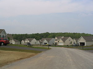
is suburban in character, consisting primarily of single-family tract housing
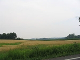
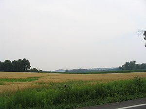
, some low-rise apartment buildings, park land, and some light industry. The balance of the town (south and west of NY 690) is primarily rural.
 The town was part of the Central New York Military Tract
of 1789 used to pay off soldiers. Most of the soldiers chose to sell their allotments for cash so that the town was briefly in the hands of land speculators until the actual residents purchased lots. Settlement began around 1791.
The Town of Van Buren was formed in 1829 from the Town of Camillus
.
, the town has a total area of 36.1 square miles (93.5 km²), of which, 35.6 square miles (92.2 km²) of it is land and 0.6 square miles (1.6 km²) of it (1.52%) is water.
The west town line is the border of Cayuga County
.
Van Buren is south of the Seneca River
/Erie Canal
. The town is also west of Onondaga Lake
. Cross Lake
is located at the west town line.
The New York State Thruway
(Interstate 90
) crosses the south part of the town. Interstate 690
is a major highway intersecting the Thruway in the eastern part of Van Buren. New York State Route 31
is a north-south highway in the middle of Van Buren, and New York State Route 173
is an east-west highway in the south part of the town. New York State Route 48
follows the course of the Seneca River in the eastern part of Van Buren.
of 2000, there were 12,667 people, 5,288 households, and 3,384 families residing in the town. The population density
was 356.2 people per square mile (137.5/km²). There were 5,618 housing units at an average density of 158.0 per square mile (61.0/km²). The racial makeup of the town was 97.05% White, 0.80% African American, 0.51% Native American, 0.41% Asian, 0.02% Pacific Islander, 0.17% from other races
, and 1.06% from two or more races. Hispanic or Latino of any race were 0.75% of the population.
There were 5,288 households out of which 29.0% had children under the age of 18 living with them, 50.6% were married couples
living together, 9.7% had a female householder with no husband present, and 36.0% were non-families. 30.0% of all households were made up of individuals and 11.4% had someone living alone who was 65 years of age or older. The average household size was 2.37 and the average family size was 2.95.
 In the town the population was spread out with 23.6% under the age of 18, 6.2% from 18 to 24, 30.2% from 25 to 44, 25.1% from 45 to 64, and 14.9% who were 65 years of age or older. The median age was 39 years. For every 100 females there were 91.6 males. For every 100 females age 18 and over, there were 88.3 males.
The median income for a household in the town was $43,003, and the median income for a family was $50,724. Males had a median income of $37,230 versus $26,842 for females. The per capita income
for the town was $20,997. About 4.9% of families and 6.6% of the population were below the poverty line, including 7.6% of those under age 18 and 6.2% of those age 65 or over.
Town
A town is a human settlement larger than a village but smaller than a city. The size a settlement must be in order to be called a "town" varies considerably in different parts of the world, so that, for example, many American "small towns" seem to British people to be no more than villages, while...
located in Onondaga County
Onondaga County, New York
Onondaga County is a county located in the U.S. state of New York. As of the 2010 census, the population was 467,026. The county seat is Syracuse.Onondaga County is part of the Syracuse, NY Metropolitan Statistical Area....
, New York
New York
New York is a state in the Northeastern region of the United States. It is the nation's third most populous state. New York is bordered by New Jersey and Pennsylvania to the south, and by Connecticut, Massachusetts and Vermont to the east...
, United States
United States
The United States of America is a federal constitutional republic comprising fifty states and a federal district...
. As of the 2000 census, the town had a population of 12,667. The town is named after future President Martin van Buren
Martin Van Buren
Martin Van Buren was the eighth President of the United States . Before his presidency, he was the eighth Vice President and the tenth Secretary of State, under Andrew Jackson ....
, who was then governor of the state.
The Town of Van Buren is located northwest of the City of Syracuse
Syracuse, New York
Syracuse is a city in and the county seat of Onondaga County, New York, United States, the largest U.S. city with the name "Syracuse", and the fifth most populous city in the state. At the 2010 census, the city population was 145,170, and its metropolitan area had a population of 742,603...
and is in the northwest part of the county. The portion of the town north and east of New York State Route 690
New York State Route 690
New York State Route 690 is a state highway in Central New York. NY 690's southern terminus is at an interchange with the New York State Thruway and Interstate 690 in Van Buren. The northern terminus is at an intersection with NY 48 and NY 631 in Lysander...
and south of the Seneca River
Seneca River (New York)
The Seneca River in central New York flows from west to east, from Seneca Lake, through the Montezuma Marsh at the north end of Cayuga Lake to the Seneca's confluence with the Oneida and Oswego rivers at the Three Rivers area north of Syracuse. Much of the river has been channelized to form part...
is suburban in character, consisting primarily of single-family tract housing
Tract housing
Tract housing is a style of housing development in which multiple similar homes are built on a tract of land which is subdivided into individual small lots...
, some low-rise apartment buildings, park land, and some light industry. The balance of the town (south and west of NY 690) is primarily rural.
History
Central New York Military Tract
The Military Tract of Central New York, also called the New Military Tract, consisted of nearly two million acres of bounty land set aside to compensate New York’s soldiers after their participation in the Revolutionary War....
of 1789 used to pay off soldiers. Most of the soldiers chose to sell their allotments for cash so that the town was briefly in the hands of land speculators until the actual residents purchased lots. Settlement began around 1791.
The Town of Van Buren was formed in 1829 from the Town of Camillus
Camillus (town), New York
Camillus is a town in Onondaga County, New York, U.S. The population was 24,167 at the 2010 census. The town was named after Roman military leader Marcus Furius Camillus by a clerk interested in the classics....
.
Geography
According to the United States Census BureauUnited States Census Bureau
The United States Census Bureau is the government agency that is responsible for the United States Census. It also gathers other national demographic and economic data...
, the town has a total area of 36.1 square miles (93.5 km²), of which, 35.6 square miles (92.2 km²) of it is land and 0.6 square miles (1.6 km²) of it (1.52%) is water.
The west town line is the border of Cayuga County
Cayuga County, New York
Cayuga County is a county located in the U.S. state of New York. It was named for one of the tribes of Indians in the Iroquois Confederation. Its county seat is Auburn.- History :...
.
Van Buren is south of the Seneca River
Seneca River (New York)
The Seneca River in central New York flows from west to east, from Seneca Lake, through the Montezuma Marsh at the north end of Cayuga Lake to the Seneca's confluence with the Oneida and Oswego rivers at the Three Rivers area north of Syracuse. Much of the river has been channelized to form part...
/Erie Canal
Erie Canal
The Erie Canal is a waterway in New York that runs about from Albany, New York, on the Hudson River to Buffalo, New York, at Lake Erie, completing a navigable water route from the Atlantic Ocean to the Great Lakes. The canal contains 36 locks and encompasses a total elevation differential of...
. The town is also west of Onondaga Lake
Onondaga Lake
Onondaga Lake is a lake in Central New York located northwest of Syracuse, New York. The southeastern end of the lake and the southwestern shore abut industrial areas and expressways; the northeastern shore and northwestern end border a series of parks and museums. Although it is near the Finger...
. Cross Lake
Cross Lake
Cross Lake lies on the border of Cayuga and Onondaga Counties in New York. Cross Lake lies within the boundaries of the traditional Onondaga Indian Nation. The lake is reputed in local tradition to be the boyhood home of Hiawatha, the great peace maker...
is located at the west town line.
The New York State Thruway
New York State Thruway
The New York State Thruway is a system of limited-access highways located within the state of New York in the United States. The system, known officially as the Governor Thomas E. Dewey Thruway for former New York Governor Thomas E. Dewey, is operated by the New York State Thruway Authority and...
(Interstate 90
Interstate 90
Interstate 90 is the longest Interstate Highway in the United States at . It is the northernmost coast-to-coast interstate, and parallels US 20 for the most part. Its western terminus is in Seattle, at Edgar Martinez Drive S. near Safeco Field and CenturyLink Field, and its eastern terminus is in...
) crosses the south part of the town. Interstate 690
Interstate 690
Interstate 690 is an auxiliary Interstate Highway that extends for through the vicinity of Syracuse, New York, in the United States. It is a spur of I-90 that travels southeast from Thruway exit 39 in Van Buren to I-481 in DeWitt...
is a major highway intersecting the Thruway in the eastern part of Van Buren. New York State Route 31
New York State Route 31
New York State Route 31 is a state highway that extends for across western and central New York in the United States. The western terminus of the route is at an intersection with NY 104 in the city of Niagara Falls. Its eastern terminus is at a traffic circle with NY 26 in Vernon...
is a north-south highway in the middle of Van Buren, and New York State Route 173
New York State Route 173
New York State Route 173 is a state highway located in the Syracuse area of central New York, United States. It takes a slightly bow-shaped route from NY 31 in the town of Van Buren to NY 5 in Chittenango, gently curving to the south of Downtown Syracuse in the center of its routing...
is an east-west highway in the south part of the town. New York State Route 48
New York State Route 48
New York State Route 48 is a north–south state highway in Central New York in the United States. The southern terminus of the route is located at Interstate 690 exit 3 near the interchange between I-690 and the New York State Thruway in Van Buren, northwest of Syracuse...
follows the course of the Seneca River in the eastern part of Van Buren.
Demographics
As of the censusCensus
A census is the procedure of systematically acquiring and recording information about the members of a given population. It is a regularly occurring and official count of a particular population. The term is used mostly in connection with national population and housing censuses; other common...
of 2000, there were 12,667 people, 5,288 households, and 3,384 families residing in the town. The population density
Population density
Population density is a measurement of population per unit area or unit volume. It is frequently applied to living organisms, and particularly to humans...
was 356.2 people per square mile (137.5/km²). There were 5,618 housing units at an average density of 158.0 per square mile (61.0/km²). The racial makeup of the town was 97.05% White, 0.80% African American, 0.51% Native American, 0.41% Asian, 0.02% Pacific Islander, 0.17% from other races
Race (United States Census)
Race and ethnicity in the United States Census, as defined by the Federal Office of Management and Budget and the United States Census Bureau, are self-identification data items in which residents choose the race or races with which they most closely identify, and indicate whether or not they are...
, and 1.06% from two or more races. Hispanic or Latino of any race were 0.75% of the population.
There were 5,288 households out of which 29.0% had children under the age of 18 living with them, 50.6% were married couples
Marriage
Marriage is a social union or legal contract between people that creates kinship. It is an institution in which interpersonal relationships, usually intimate and sexual, are acknowledged in a variety of ways, depending on the culture or subculture in which it is found...
living together, 9.7% had a female householder with no husband present, and 36.0% were non-families. 30.0% of all households were made up of individuals and 11.4% had someone living alone who was 65 years of age or older. The average household size was 2.37 and the average family size was 2.95.
The median income for a household in the town was $43,003, and the median income for a family was $50,724. Males had a median income of $37,230 versus $26,842 for females. The per capita income
Per capita income
Per capita income or income per person is a measure of mean income within an economic aggregate, such as a country or city. It is calculated by taking a measure of all sources of income in the aggregate and dividing it by the total population...
for the town was $20,997. About 4.9% of families and 6.6% of the population were below the poverty line, including 7.6% of those under age 18 and 6.2% of those age 65 or over.
Communities and locations in Van Buren
- Bangall —- A hamlet north of Ionia. It was called "Sand Spring" when the first sawmill in the town was built there in 1815.
- BaldwinsvilleBaldwinsville, New YorkBaldwinsville is a village in Onondaga County, New York, United States. The population was 7,053 at the 2000 census. It is part of the Syracuse Metropolitan Statistical Area....
—- The south part of the Village of Baldwinsville. - Crows Hollow —- A location northeast of Ionia.
- Daboll Corners – A location east of Jack's Reef.
- Ionia (formerly "Barns Corners") – A hamlet near the south town line on NY-173. Ionia was the site of the first significant settlement.
- Jack's ReefJack's Reef, New YorkJack's Reef is a hamlet in the Town of Van Buren, New York in Onondaga County, New York. It was developed around an inn, extant today as a restaurant, where Old Route 31 bent around a large oxbow in the Seneca River. Subsequently a canal was cut about a mile to the north, which shortened the...
– A hamlet in the western part of the town by the Seneca River. - Jones Point – A location west of Jack's Reef on the south shore of Cross Lake.
- MemphisMemphis, New YorkMemphis is a hamlet in the Town of Van Buren, west of Syracuse in Onondaga County, New York, United States.Because of its location on the south town line of Van Buren, part of Memphis can be considered to be also in the Towns of Elbridge and Camillus...
—- A hamlet at the south town line, south of Ionia. It was formerly called "Canton." - Seneca KnollsSeneca Knolls, New YorkSeneca Knolls is a hamlet in Onondaga County, New York, United States. The population was 2,138 at the 2000 census.Seneca Knolls is in the eastern part of the Town of Van Buren.-Geography:...
—- A hamlet - Stiles —- A hamlet near the east town line and southeast of Seneca Knolls.
- Van Buren —- The hamlet of Van Buren is in the eastern part of the town near Seneca Knolls.
- Village GreenVillage Green, New YorkVillage Green is a hamlet in Onondaga County, New York, United States. The population was 3,945 at the 2000 census.Village Green is in the eastern part of the Town of Van Buren.-Geography:...
—- A hamlet southeast of Baldwinsville. - Warners —- A hamlet at the south town line on NY-173 near the Thruway.